
Rigobert Bonne (1729 - 1795)
Profile :
As Royal Hydrographer, Bonne`s principle interest lay in the production of marine charts but he issued a number of other works, often including maps by fellow cartographers. He also provided maps for a notable atlas by Guillaume Raynal and for an Historical Atlas and Encyclopedia published in association with Nicholas Desmaret (1725 – 1805)
Rigobert Bonne (52)
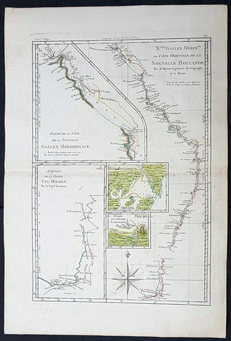
1785 Rigobert Bonne Antique Map of Australia, Botany Bay, Tasmania & Queensland
- Title : Nlle. Galles Merid. ou Cote Orientale de la Nouvelle Hollande Par M Bonne...Baie Botanique; Entree de la Riviere Endeavour; Esquisse de la Terre Van Diemen...
- Size: 17in x 11 1/2in (430mm x 285mm)
- Condition: (A+) Fine Condition
- Date : 1785
- Ref #: 93127
Description:
This original hand coloured antique copper-plate engraved map of the discoveries of Captain James Cook and the east coast of Australia in 1770 was published in 1785 edition of Atlas des toutes les parties connues du globe terrestre by Rigobert Bonne & Guillaume Raynal.
General Definitions:
Paper thickness and quality: - Heavy and stable
Paper color : - off white
Age of map color: - Original
Colors used: - Yellow, green, blue, pink
General color appearance: - Authentic
Paper size: - 17in x 11 1/2in (430mm x 285mm)
Plate size: - 14 1/2in x 10in (370mm x 255mm)
Margins: - Min 1/2in (12mm)
Imperfections:
Margins: - None
Plate area: - None
Verso: - None
Background:
Interesting map illustrating the discoveries in Australia by Captain Cook in 1770 and all the place names along the coastline. The map also 4 inset maps of Botany Bay, the Endeavour River QLD, the SE coast of Van Diemens Land or Tasmania and the northern coastline of QLD.
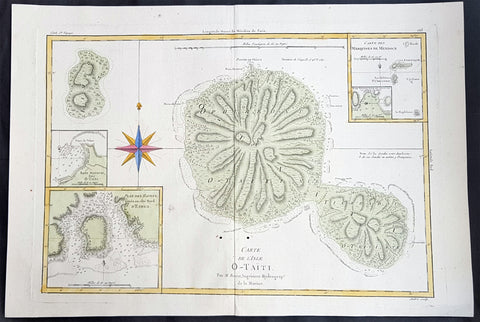
1780 Rigobert Bonne Large Antique Map of Tahiti
- Title : Carte De L 'Isle O - Taiti...Par M. Bonne...
- Date : 1780
- Condition: (A) Very Good Condition
- Ref: 40570
- Size: 15in x 11in (400mm x 275mm)
Description:
This fine original copper plate engraved antique map by Rigobert Bonne was published in the 1780 edition of Atlas des toutes les parties connues du globe terrestre by Guillaume Raynal. (Ref Tooley M&B)
General Definitions:
Paper thickness and quality: - Heavy and stable
Paper color : - off white
Age of map color: - Early
Colors used: - Yellow, Green, pink
General color appearance: - Authentic
Paper size: - 16 ½in x 11 ½in; (420mm x 295mm)
Plate size: - 14 ½in x 10in; (370mm x 250mm)
Margins: - Min 1/2in (12mm)
Imperfections:
Margins: - None
Plate area: - Two very small worm holes adjacent to bottom centerfold
Verso: - None
Background:
Tahiti previously also known as Otaheite is the largest island in the Windward group of French Polynesia. The island is located in the archipelago of the Society Islands in the central Southern Pacific Ocean.
The first European to have visited Tahiti according to existing records was lieutenant Samuel Wallis, who was circumnavigating the globe in HMS Dolphin, sighting the island on 18 June 1767, and eventually harboring in Matavai Bay. This bay was situated on the territory of the chiefdom of Pare-Arue, governed by Tu (Tu-nui-e-a a-i-te-Atua) and his regent Tutaha, and the chiefdom of Ha apape, governed by Amo and his wife Oberea (Purea). Wallis named the island King Georges Island. The first contacts were difficult, since on the 24 and 26 June 1767, Tahitian warriors in canoes showed aggression towards the British, hurling stones from their slings. In retaliation, the British sailors opened fire on the warriors in the canoes and on the hills. In reaction to this powerful counter-attack, the Tahitians laid down peace offerings for the British. Following this episode, Samuel Wallis was able to establish cordial relations with the female chieftain “Oberea “ (Purea) and remained on the island until 27 July 1767.
In July 1768, Captain James Cook was commissioned by the Royal Society and on orders from the Lords Commissioners of the Admiralty to observe the transit of Venus across the sun, a phenomenon that would be visible from Tahiti on 3 June 1769. He arrived in Tahitis Matavai Bay, commanding the HMS Endeavour on 12 April 1769. On 14 April, Cook met with Tutaha and Tepau. On 15 April, Cook picked the site for a fortified camp at Point Venus along with Banks, Parkinson, Daniel Solander, to protect Charles Greens observatory. The length of stay enabled them to undertake for the first time real ethnographic and scientific observations of the island. Assisted by the botanist Joseph Banks, and by the artist Sydney Parkinson, Cook gathered valuable information on the fauna and flora, as well as the native society, language and customs, including the proper name of the island, Otaheite. On 28 April, Cook met Purea and Tupaia, and Tupaia befriended Banks following the transit. On 21 June, Amo visited Cook, and then on 25 June, Pohuetea visited, signifying another chief seeking to ally himself with the British.
Cook and Banks circumnavigated the island from 26 June to 1 July. On the exploration, they met Ahio, chief of Ha apaiano o or Papenoo, Rita, chief of Hitia a, Pahairro, chief of Pueu, Vehiatua, chief of Tautra, Matahiapo, chief of Teahupo o, Tutea, chief of Vaira o, and Moe, chief of Afa Ahiti. In Papara, guided by Tupaia, they investigated the ruins of Mahaiatea marae, an impressive structure containing a stone pyramid or ahu, measuring 44 feet high, 267 feet long and 87 feet wide. Cook and the Endeavour departed Tahiti on 13 July 1769, taking Raiatean navigator Tupaia along for his geographic knowledge of the islands.
Cook returned to Tahiti between 15 August and 1 September 1773, greeted by the chiefs Tai and Puhi, besides the youg ari i Vehiatua II and his stepfather Ti itorea. Cook anchored in Vaitepiha Bay before returning to Point Venus where he met Tu, the paramount chief. Cook picked up two passengers from Tahiti during this trip, Porea and Mai, with Hitihiti later replacing Porea when Cook stopped at Raiatea. Cook took Hitihiti to Tahiti on 22 April, during his return leg. Then, Cook departed Tahiti on 14 May 1774.
During his final visit, Cook returned Mai to Tahiti on 12 Aug. 1777, after Mais long visit in England. Cook also brought two Maori from Queen Charlotte Sound, Te Weherua and Koa. Cook first harbored in Vaitepiha Bay, where he visited Vehiatua II s funeral bier and the prefabricated Spanish mission house. Cook also met Vehiatua III, and inscribed on the back of the Spanish cross, Georgius tertius Rex Annis 1767, 69, 73, 74 & 77, as a counterpoint to Christus Vincit Carolus III imperat 1774 on the front. On 23 Aug., Cook sailed for Matavai Bay, where he met Tu, his father Teu, his mother Tetupaia, his brothers Ari ipaea and Vaetua, and his sisters Ari ipaea-vahine, Tetua-te-ahamai, and Auo. Cook also observed a human sacrifice, taata tapu, at the Utu-ai-mahurau marae, and 49 skulls from previous victims.
On 29 Sept. 1777, Cook sailed for Papetoai Bay on Moorea. Cook met Mahine in an act of friendship on 3 Oct., though he was an enemy of Tu. When a goat kid was stolen on 6 Oct., Cook in a rampage, ordered the burning of houses and canoes until it was returned. Cook sailed for Huahine on 11 Oct., Raiatea on 2 Nov., and Borabora on 7 Dec.
On 26 October 1788, HMS Bounty, under the command of Captain William Bligh, landed in Tahiti with the mission of carrying Tahitian breadfruit trees (Tahitian: uru) to the Caribbean. Sir Joseph Banks, the botanist from James Cooks first expedition, had concluded that this plant would be ideal to feed the African slaves working in the Caribbean plantations at very little cost. The crew remained in Tahiti for about five months, the time needed to transplant the seedlings of the trees. Three weeks after leaving Tahiti, on 28 April 1789, the crew mutinied on the initiative of Fletcher Christian. The mutineers seized the ship and set the captain and most of those members of the crew who remained loyal to him adrift in a ships boat. A group of mutineers then went back to settle in Tahiti.
Although various explorers had refused to get involved in tribal conflicts, the mutineers from the Bounty offered their services as mercenaries and furnished arms to the family which became the Pōmare Dynasty. The chief Tū knew how to use their presence in the harbours favoured by sailors to his advantage. As a result of his alliance with the mutineers, he succeeded in considerably increasing his supremacy over the island of Tahiti.
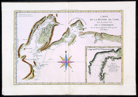
1780 Bonne Cook Antique Map Prince William Sound Alaska
- Title : Carte De La Riviere De Cook ...Par M. Bonne...
- Ref #: 40571
- Size: 15 1/2in x 10in (395mm x 255mm)
- Date : 1780
- Condition: (A+) Fine Condition
Description:
This fine beautifully hand coloured original antique map of Prince William Sound and the Cook inlet - with an inset map of Samganoodha inlet and tracks showing Cooks survey routes within Prince William Sound - was published by Rigobert Bonne in the 1780 edition of Atlas des toutes les parties connues du globe terrestre by Guillaume Raynal. (Ref Tooley M&B)
General Description:
Paper thickness and quality: - Heavy and stable
Paper color: - White
Age of map color: - Early
Colors used: -.Pink, green, yellow, blue
General color appearance: - Authentic and fresh
Paper size: - 15 1/2in x 10in (395mm x 255mm)
Plate size: - 14in x 9in (355mm x 230mm)
Margins: - Min 1in (25mm)
Imperfections:
Margins: - None
Plate area: - Two very small worm holes adjacent to bottom centerfold
Verso: - None
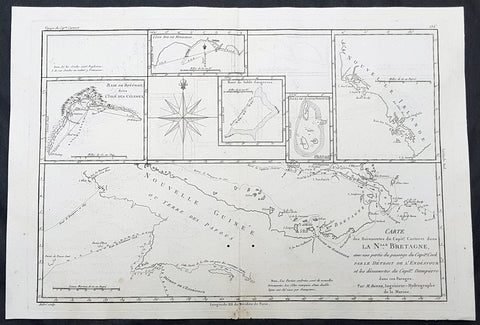
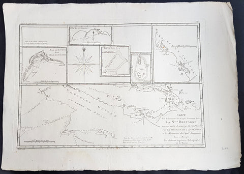
1780 Rigobert Bonne Antique Map of New Guinea, William Dampier 1699 - 5 Harbours
- Title : Carte des Decouvertes du Capt,. Carteret dans La Nlle. Bretagne..Par M Bonne
- Date : 1780
- Size: 16in x 11in (405mm x 2805mm)
- Ref #: 40581
- Condition: (A+) Fine Condition
Description:
This fine original copper plate engraved antique map of Papua New Guinea - and the early discoveries of William Dampier and the later passage of Cooks ship the Endeavor through the straits between Australia and New Guinea, by Rigobert Bonne was published in the 1780 edition of Atlas des toutes les parties connues du globe terrestre by Guillaume Raynal.
The map also contains the bays, Harbours and coastlines of several Islands of the Pacific including New Ireland, Philippines, Indonesia.(Ref Tooley M&B)
General Definitions:
Paper thickness and quality: - Heavy and stable
Paper color : - off white
Age of map color: - Early
Colors used: - Yellow, Green, pink
General color appearance: - Authentic
Paper size: - 16 ½in x 11 ½in; (420mm x 295mm)
Plate size: - 14 ½in x 10in; (370mm x 250mm)
Margins: - Min 1/2in (12mm)
Imperfections:
Margins: - None
Plate area: - Light offsetting
Verso: - None
Background:
William Dampier 1651 - 1715 was an English explorer and navigator who became the first Englishman to explore parts of what is today Australia, and the first person to circumnavigate the world three times. He has also been described as Australia\'s first natural historian, as well as one of the most important British explorers of the period between Sir Walter Raleigh and James Cook.
After impressing the Admiralty with his book A New Voyage Round the World, Dampier was given command of a Royal Navy ship and made important discoveries in Western Australia, before being court-martialled for cruelty. On a later voyage he rescued Alexander Selkirk, a former crewmate who may have inspired Daniel Defoes Robinson Crusoe. Others influenced by Dampier include James Cook, Horatio Nelson, Charles Darwin, and Alfred Russel Wallace.
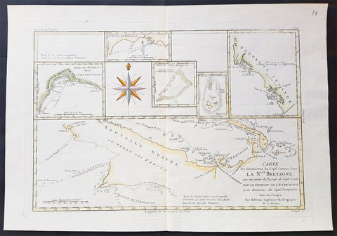
1780 Rigobert Bonne Antique Map of New Guinea, William Dampier 1699 - 5 Harbours
- Title : Carte des Decouvertes du Capt,. Carteret dans La Nlle. Bretagne..Par M Bonne
- Date : 1780
- Size: 17in x 12 1/2in (430mm x 310mm)
- Ref #: 16105
- Condition: (A+) Fine Condition
Description:
This fine original copper plate engraved antique map of Papua New Guinea - and the early discoveries of William Dampier and the later passage of Cooks ship the Endeavor through the straits between Australia and New Guinea, by Rigobert Bonne was published in the 1780 edition of Atlas des toutes les parties connues du globe terrestre by Guillaume Raynal.
The map also contains the bays, Harbours and coastlines of several Islands of the Pacific including New Ireland, Philippines, Indonesia.(Ref Tooley M&B)
General Definitions:
Paper thickness and quality: - Heavy and stable
Paper color : - off white
Age of map color: -
Colors used: -
General color appearance: -
Paper size: - 17in x 12 1/2in (430mm x 310mm)
Plate size: - 14 ½in x 10in; (370mm x 250mm)
Margins: - Min 1/2in (12mm)
Imperfections:
Margins: - None
Plate area: - None
Verso: - None
Background:
William Dampier 1651 - 1715 was an English explorer and navigator who became the first Englishman to explore parts of what is today Australia, and the first person to circumnavigate the world three times. He has also been described as Australia\'s first natural historian, as well as one of the most important British explorers of the period between Sir Walter Raleigh and James Cook.
After impressing the Admiralty with his book A New Voyage Round the World, Dampier was given command of a Royal Navy ship and made important discoveries in Western Australia, before being court-martialled for cruelty. On a later voyage he rescued Alexander Selkirk, a former crewmate who may have inspired Daniel Defoes Robinson Crusoe. Others influenced by Dampier include James Cook, Horatio Nelson, Charles Darwin, and Alfred Russel Wallace.
1780 Rigobert Bonne Antique Map of New Guinea, William Dampier 1699 - 5 Harbours
- Title : Carte des Decouvertes du Capt,. Carteret dans La Nlle. Bretagne..Par M Bonne
- Date : 1780
- Size: 16in x 11in (405mm x 2805mm)
- Ref #: 32155
- Condition: (A+) Fine Condition
Description:
This fine original copper plate engraved antique map of Papua New Guinea - and the early discoveries of William Dampier and the later passage of Cooks ship the Endeavor through the straits between Australia and New Guinea, by Rigobert Bonne was published in the 1780 edition of Atlas des toutes les parties connues du globe terrestre by Guillaume Raynal.
The map also contains the bays, Harbours and coastlines of several Islands of the Pacific including New Ireland, Philippines, Indonesia.(Ref Tooley M&B)
General Definitions:
Paper thickness and quality: - Heavy and stable
Paper color : - off white
Age of map color: - Early
Colors used: - Yellow, Green, pink
General color appearance: - Authentic
Paper size: - 16 ½in x 11 ½in; (420mm x 295mm)
Plate size: - 14 ½in x 10in; (370mm x 250mm)
Margins: - Min 1/2in (12mm)
Imperfections:
Margins: - None
Plate area: - None
Verso: - None
Background:
William Dampier 1651 - 1715 was an English explorer and navigator who became the first Englishman to explore parts of what is today Australia, and the first person to circumnavigate the world three times. He has also been described as Australia\'s first natural historian, as well as one of the most important British explorers of the period between Sir Walter Raleigh and James Cook.
After impressing the Admiralty with his book A New Voyage Round the World, Dampier was given command of a Royal Navy ship and made important discoveries in Western Australia, before being court-martialled for cruelty. On a later voyage he rescued Alexander Selkirk, a former crewmate who may have inspired Daniel Defoes Robinson Crusoe. Others influenced by Dampier include James Cook, Horatio Nelson, Charles Darwin, and Alfred Russel Wallace.
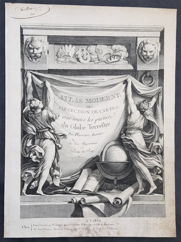
1762 Bonne, Janvier, & Zannoni Original Antique Atlas Title Page to Atlas Modern
- Title : Atlas Moderne ou Collection De Cartes Sur toutes les parties du Globe Terrestre
- Size: 14in x 10in (355mm x 255mm)
- Ref #: 92277
- Date : 1762
- Condition: (A+) Fine Condition
Description:
This original copper-plate engraved antique frontispiece from the atlas Atlas Moderne of a Collection of Maps by Rigobert Bonne, Jean Janvier, & Rizzi Zannoni was published by Jean Lattre in 1762, dated.
General Definitions:
Paper thickness and quality: - Heavy and stable
Paper color : - off white
Age of map color: -
Colors used: -
General color appearance: -
Paper size: - 14in x 10in (355mm x 255mm)
Plate size: - 14in x 10in (355mm x 255mm)
Margins: - Min 1/2in (12mm)
Imperfections:
Margins: - Light soiling in margins
Plate area: - None
Verso: - None
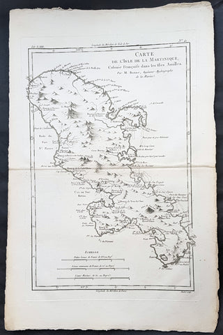
1780 Rigobert Bonne Antique Map of Caribbean Island of Martinique
- Title : Carte De L Isle De La Martinique...Par M Bonne
- Date : 1780
- Size: 16 1/2in x 11in (420mm x 280mm)
- Ref #: 40844
- Condition: (A+) Fine Condition
Description:
This fine original copper plate engraved antique map of Caribbean Island of Martinique by Rigobert Bonne was published in the 1780 edition of Atlas des toutes les parties connues du globe terrestre by Guillaume Raynal.
General Definitions:
Paper thickness and quality: - Heavy and stable
Paper color : - off white
Age of map color: -
Colors used: -
General color appearance: -
Paper size: - 16 1/2in x 11in (420mm x 280mm)
Plate size: - 13in x 9in (330mm x 230mm)
Margins: - Min 1/2in (12mm)
Imperfections:
Margins: - None
Plate area: - None
Verso: - None
Background:
Martinique is an insular region of France located in the Lesser Antilles of the West Indies in the eastern Caribbean Sea.
Martinique was charted by Columbus in 1493, but Spain had little interest in the territory.
On 15 September 1635, Pierre Belain d Esnambuc, French governor of the island of St. Kitts, landed in the harbor of St. Pierre with 150 French settlers after being driven off St. Kitts by the English. D\'Esnambuc claimed Martinique for the French King Louis XIII and the French Compagnie des Îles de l\'Amérique (Company of the American Islands), and established the first European settlement at Fort Saint-Pierre (now St. Pierre). D\'Esnambuc died in 1636, leaving the company and Martinique in the hands of his nephew, Jacques Dyel du Parquet, who in 1637, became governor of the island.
In 1636, the indigenous Caribs rose against the settlers to drive them off the island in the first of many skirmishes. The French successfully repelled the natives and forced them to retreat to the eastern part of the island, on the Caravelle Peninsula in the region then known as the Capesterre. When the Carib revolted against French rule in 1658, the Governor Charles Houël du Petit Pré retaliated with war against them. Many were killed; those who survived were taken captive and expelled from the island. Some Carib had fled to Dominica or St. Vincent, where the French agreed to leave them at peace.
Because there were few Catholic priests in the French Antilles, many of the earliest French settlers were Huguenots who sought greater religious freedom than what they could experience in mainland France. They were quite industrious and became quite prosperous. Although edicts from King Louis XIVs court regularly came to the islands to suppress the Protestant heretics, these were mostly ignored by island authorities until Louis XIVs Edict of Revocation in 1685.
From September 1686 to early 1688, the French crown used Martinique as a threat and a dumping ground for mainland Huguenots who refused to reconvert to Catholicism. Over 1,000 Huguenots were transported to Martinique during this period, usually under miserable and crowded ship conditions that caused many of them to die en route. Those that survived the trip were distributed to the island planters as Engagés (Indentured servants) under the system of serf peonage that prevailed in the French Antilles at the time.
As many of the planters on Martinique were themselves Huguenot, and who were sharing in the suffering under the harsh strictures of the Revocation, they began plotting to emigrate from Martinique with many of their recently arrived brethren. Many of them were encouraged by their Catholic brethren who looked forward to the departure of the heretics and seizing their property for themselves. By 1688, nearly all of Martinique\'s French Protestant population had escaped to the British American colonies or Protestant countries back home. The policy decimated the population of Martinique and the rest of the French Antilles and set back their colonization by decades, causing the French king to relax his policies in the islands yet leaving the islands susceptible to British occupation over the next century.
Under Governor of the Antilles Charles de Courbon, comte de Blénac, Martinique served as a home port for French pirates including Captain Crapeau, Etienne de Montauban, and Mathurin Desmarestz. In later years pirate Bartholomew Roberts styled his jolly roger as a black flag depicting a pirate standing on two skulls labeled ABH and AMH for A Barbadian\'s Head and A Martinican\'s Head, after Governors of those two islands sent warships to capture Roberts.
Martinique was occupied several times by the British including once during the Seven Years\' War and twice during the Napoleonic Wars. Britain controlled the island almost continuously from 1794–1815, when it was traded back to France at the conclusion of the Napoleonic Wars. Martinique has remained a French possession since then.
As sugar prices declined in the early 1800s, the planter class lost political influence. In 1848, Victor Schoelcher persuaded the French government to end slavery in the French West Indies.
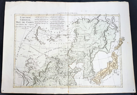
1780 Rigobert Bonne Antique Map of Northern China, Mongolia, Korea Japan Tartary
- Title : Tartarie Chinoise, Roy. De Coree, et Isles Du Japon... Par M. Bonne
- Ref #: 40537
- Size: 16in x 11in (410mm x 270mm)
- Date : 1780
- Condition: (A+) Fine Condition
Description:
This fine original copper plate engraved antique map of Northern China, Mongolia, Korea Japan & eastern Siberia by Rigobert Bonne was published in the 1780 edition of Atlas des toutes les parties connues du globe terrestre by Guillaume Raynal.
General Definitions:
Paper thickness and quality: - Heavy and stable
Paper color : - off white
Age of map color: - Early
Colors used: - Yellow, Green, pink
General color appearance: - Authentic
Paper size: - 16in x 11in (410mm x 270mm)
Plate size: - 14 1/2in x 10in (370mm x 255mm)
Margins: - Min 1/2in (12mm)
Imperfections:
Margins: - None
Plate area: - None
Verso: - None
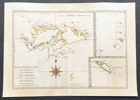
1780 Rigobert Bonne Old, Antique Map of the Falkland Islands - Malvinas Is.
- Title : Isles Maidenland de Hawkins et le Detroit De Fakland Ces Isles sont nommes Malouines... Par M. Bonne
- Ref #: 35488-1
- Size: 16in x 11in (410mm x 270mm)
- Date : 1780
- Condition: (A+) Fine Condition
Description:
This fine hand coloured original antique map of The Falkland or Malvinas, with inset maps of the South Sandwich Islands and George Island - both making up parts of the Falklands - by Rigobert Bonne was published in the 1780 edition of Atlas des toutes les parties connues du globe terrestre by Guillaume Raynal. (Ref Tooley M&B)
General Description:
Paper thickness and quality: - Heavy and stable
Paper color: - White
Age of map color: - Early
Colors used: - Green, yellow
General color appearance: - Authentic
Paper size: - 16in x 11in (410mm x 270mm)
Plate size: - 14 1/2in x 10in (370mm x 255mm)
Margins: - Min 1/2in (12mm)
Imperfections:
Margins: - Light age toning
Plate area: - Light age toning
Verso: - Light age toning
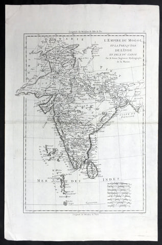
1780 Bonne Antique Map of India - Sri Lanka to Tibet
- Title : L Empire Du Mogol et la Presqu Isle De L Inde en deca Du Gange... Par M. Bonne
- Ref #: 21983
- Size: 17in x 11 1/2in (430mm x 290mm)
- Date : 1780
- Condition: (A+) Fine Condition
Description:
This fine original highly detailed antique map of India from Sri Lanka to Tibet by Rigobert Bonne was published in the 1780 edition of Atlas des toutes les parties connues du globe terrestre by Guillaume Raynal. (Ref Tooley M&B)
General Description:
Paper thickness and quality: - Heavy and stable
Paper color: - White
Age of map color: -
Colors used: -
General color appearance: -
Paper size: - 17in x 11 1/2in (430mm x 290mm)
Plate size: - 14 1/2in x 10 1/2in (370mm x 265mm)
Margins: - Min 1in (25mm)
Imperfections:
Margins: - None
Plate area: - None
Verso: - None
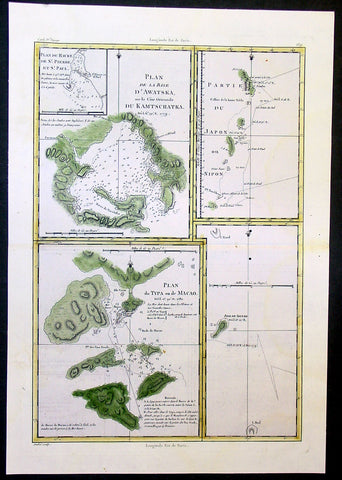
1780 Bonne Cook Antique Maps of Russia, Japan, Macao China, Alaska
- Title : Plan de la Baye D' Awatska; Partie Du Japon ou Nippon; Plan du Typa ou de Macao; Isle de Soufre
- Date : 1780
- Condition: (A) Very Good Condition
- Ref: 40584
- Size: 16in x 11in (405mm x 280mm)
Description:
This beautifully hand coloured original antique map of 4 regions of the North Pacific explored by Captain James Cook during his third Voyage of Discovery and tracks showing Cooks survey routes within Prince William Sound - was published by Rigobert Bonne in the 1780 edition of Atlas des toutes les parties connues du globe terrestre by Guillaume Raynal.
The 4 maps are;
1. Avacha Bay, Kamchatka Penninsular Russia.
2. East coast and Islands of Japan
3. Town & Islands of Macao, China
4. Islands of Soufre Vanauatu South Pacific. (Ref Tooley M&B)
General Description:
Paper thickness and quality: - Heavy and stable
Paper color: - White
Age of map color: - Early
Colors used: -Green, yellow
General color appearance: - Authentic and fresh
Paper size: - 16in x 11in (405mm x 280mm)
Plate size: - 14 1/2in x 10in (370mm x 255mm)
Margins: - Min 1in (25mm)
Imperfections:
Margins: - None
Plate area: - Two very small worm holes adjacent to right centerfold
Verso: - None
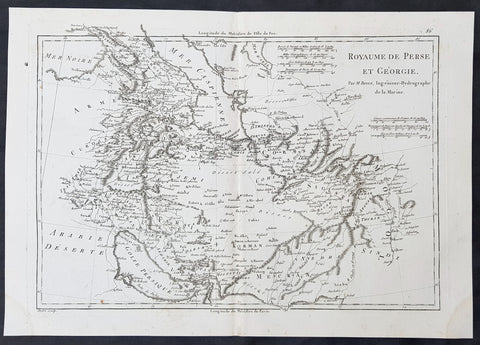
1780 R. Bonne Original Antique Map of Caucasus Georgia, Iran, Armenia, Pakistan
- Title : Royaume de Perse et Georgia...M Bonne
- Size: 15in x 10in (380mm x 255mm)
- Ref #: 40531
- Date : 1780
- Condition: (A+) Fine Condition
Description:
This original copper-plate engraved map was published in 1780 edition of Atllas des toutes les parties connues du globe terrestre by Rigobert Bonne & Guillaume Raynal.
General Definitions:
Paper thickness and quality: - Heavy and stable
Paper color : - off white
Age of map color: -
Colors used: -
General color appearance: -
Paper size: - 15in x 10in (380mm x 255mm)
Plate size: - 13in x 9in (330mm x 230mm)
Margins: - Min 1in (25mm)
Imperfections:
Margins: - None
Plate area: - None
Verso: - None
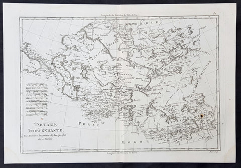
1780 R. Bonne Original Antique Map of Central Asia Turkestan - Caspian to China
- Title : Tartarie Independante...M Bonne
- Size: 15in x 10in (380mm x 255mm)
- Ref #: 40532
- Date : 1780
- Condition: (A+) Fine Condition
Description:
This original copper-plate engraved map was published in 1780 edition of Atllas des toutes les parties connues du globe terrestre by Rigobert Bonne & Guillaume Raynal.
General Definitions:
Paper thickness and quality: - Heavy and stable
Paper color : - off white
Age of map color: -
Colors used: -
General color appearance: -
Paper size: - 15in x 10in (380mm x 255mm)
Plate size: - 13in x 9in (330mm x 230mm)
Margins: - Min 1in (25mm)
Imperfections:
Margins: - None
Plate area: - None
Verso: - None
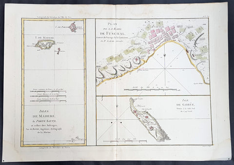
1780 Rigobert Bonne Antique Map Madeira, Porto Santo - Slave Is. Goree Senegal
- Title : Isles De Madere, de Porto Santo; Plan De La Rade De Funchal; Isle De Goree
- Ref : 40548
- Size: 16in x 11in (405mm x 280mm)
- Date : 1780
- Condition: (A+) Fine Condition
Description:
This fine original copper plate engraved antique map of the Portuguese islands of Madeira, Porto Santo, and Desertas along with a map of the Harbour of Funchal on Madeira and the infamouse Senegalise Slave Island of Goree, West Africa by Rigobert Bonne was published in the 1780 edition of Atlas des toutes les parties connues du globe terrestre by Guillaume Raynal.
General Definitions:
Paper thickness and quality: - Heavy and stable
Paper color : - off white
Age of map color: - Early
Colors used: - Yellow, pink, green, blue
General color appearance: - Authentic
Paper size: - 16in x 11in (405mm x 280mm)
Plate size: - 14 1/2in x 10 1/2in (370mm x 265mm)
Margins: - Min 1/2in (12mm)
Imperfections:
Margins: - None
Plate area: - None
Verso: - None
Background:
Madeira officially the Autonomous Region of Madeira (Região Autónoma da Madeira) is one of the two autonomous regions of Portugal (along with Azores (Região Autónoma da Açores)). It is a Portuguese archipelago situated in the north Atlantic Ocean, southwest of Portugal. Its total population was estimated in 2011 at 267,785. The capital of Madeira is Funchal, which is located on the main island\'s south coast.
The archipelago is just under 400 kilometres north of Tenerife, Canary Islands. Bermuda and Madeira, a few time zones apart, are the only land in the Atlantic on the 32nd parallel north. Since 1976, the archipelago has been one of the two autonomous regions of Portugal (the other being the Azores, located to the northwest). It includes the islands of Madeira, Porto Santo, and the Desertas, administered together with the separate archipelago of the Savage Islands.
Madeira was claimed by Portuguese sailors in the service of Prince Henry the Navigator in 1419 and settled after 1420. The archipelago is considered to be the first territorial discovery of the exploratory period of the Age of Discovery. The main harbour in Funchal has long been the leading Portuguese port in cruise liner dockings,
Île de Gorée is one of the 19 communes d\'arrondissement (i.e. districts) of the city of Dakar, Senegal.
Gorée is a small island 900 metres in length and 350 metres in width sheltered by the Cap-Vert Peninsula. Now part of the city of Dakar, it was a minor port and site of European settlement along the coast. Being almost devoid of drinking water, the island was not settled before the arrival of Europeans. The Portuguese were the first to establish a presence on Gorée c. 1450, where they built a small stone chapel and used land as a cemetery.
Gorée is known as the location of the House of Slaves (French: Maison des esclaves), built by an Afro-French Métis family about 1780–1784. The House of Slaves is one of the oldest houses on the island. It is now used as a tourist destination to show the horrors of the slave trade throughout the Atlantic world.
After the decline of the slave trade from Senegal in the 1770s and 1780s, the town became an important port for the shipment of peanuts, peanut oil, gum arabic, ivory, and other products of the legitimate trade. It was probably in relation to this trade that the so-called Maison des Esclaves was built. As discussed by historian Ana Lucia Araujo, the building started gaining reputation as a slave depot mainly because of the work of its curator Boubacar Joseph Ndiaye, who was able to move the audiences who visited the house with his performance Many public personalities visit the House of Slaves, which plays the role of a site of memory of slavery. In June 2013, President of the United States Barack Obama visited the House of Slaves.
The island of Gorée was one of the first places in Africa to be settled by Europeans, as the Portuguese settled on the island in 1444. It was captured by the United Netherlands in 1588, then the Portuguese again, and again the Dutch. They named it after the Dutch island of Goeree, before the British took it over under Robert Holmes in 1664.
After the French invasion in 1677, the island remained continuously French until 1960. There were brief periods of British occupation during the various wars fought by France and Britain. In 1960 Senegal was granted independence. The island was notably taken and occupied by the British between 1758 and 1763 following the Capture of Gorée and wider Capture of Senegal during the Seven Years\' War before being returned to France at the Treaty of Paris (1763). For a brief time between 1779 and 1783, Gorée was again under British control, until ceded again to France in 1783 at the Treaty of Paris (1783). During that time, the infamous Joseph Wall was Lieutenant Governor there, who had a man unlawfully flogged to death in 1782.
Gorée was principally a trading post, administratively attached to Saint-Louis, capital of the Colony of Senegal. Apart from slaves, beeswax, hides and grain were also traded. The population of the island fluctuated according to circumstances, from a few hundred free Africans and Creoles to about 1,500. There would have been few European residents at any one time.
In the 18th and 19th century, Gorée was home to a Franco-African Creole, or Métis, community of merchants with links to similar communities in Saint-Louis and the Gambia, and across the Atlantic to France\'s colonies in the Americas. Métis women, called signares from the Portuguese senhora descendants of African women and European traders, were especially important to the city’s business life. The signares owned ships and property and commanded male clerks. They were also famous for cultivating fashion and entertainment. One such signare, Anne Rossignol, lived in Saint-Domingue (the modern Haiti) in the 1780s before the Haitian Revolution.
In February 1794 during the French Revolution, France abolished slavery. The slave trade from Senegal stopped. In April 1801, however, Gorée was captured by the British again.
In March 1815, during his political comeback known as the Hundred Days, Napoleon definitively abolished the slave trade to build relations with Great Britain. (Scotland had never recognized slavery and England finally abolished the slave trade in 1807.) This time, abolition continued.
As the trade in slaves declined in the late eighteenth century, Gorée converted to legitimate commerce. The tiny city and port were ill-situated for the shipment of industrial quantities of peanuts, which began arriving in bulk from the mainland. Consequently, its merchants established a presence directly on the mainland, first in Rufisque (1840) and then in Dakar (1857). Many of the established families started to leave the island.
Civic franchise for the citizens of Gorée was institutionalized in 1872, when it became a French commune with an elected mayor and a municipal council. Blaise Diagne, the first African deputy elected to the French National Assembly (served 1914 to 1934), was born on Gorée. From a peak of about 4,500 in 1845, the population fell to 1,500 in 1904. In 1940 Gorée was annexed to the municipality of Dakar.
From 1913 to 1938, Gorée was home to the École normale supérieure William Ponty, a government teachers\' college run by the French Colonial Government. Many of the school\'s graduates would one day lead the struggle for independence from France.
Gorée is connected to the mainland by regular 30-minute ferry service, for pedestrians only; there are no cars on the island. Senegal’s premier tourist site, the island was listed as a UNESCO World Heritage Site in 1978. It now serves mostly as a memorial to the slave trade. Many of the historic commercial and residential buildings have been turned into restaurants and hotels to support the tourist traffic.
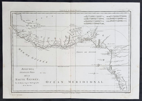
1780 Rigobert Bonne Original Antique Map Gulf of Guinea, Africa Liberia to Gabon
- Title : Royaumes Stats et Pays de La Haute Guinee...M Bonne
- Size: 15in x 10in (390mm x 255mm)
- Ref #: 40539
- Date : 1780
- Condition: (A+) Fine Condition
Description:
This original copper-plate engraved map was published in 1780 edition of Atllas des toutes les parties connues du globe terrestre by Rigobert Bonne & Guillaume Raynal.
General Definitions:
Paper thickness and quality: - Heavy and stable
Paper color : - off white
Age of map color: -
Colors used: -
General color appearance: -
Paper size: - 15in x 10in (390mm x 255mm)
Plate size: - 13in x 9in (330mm x 235mm)
Margins: - Min 1/4in (8mm)
Imperfections:
Margins: - None
Plate area: - None
Verso: - None
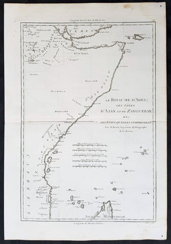
1780 Rigobert Bonne Original Antique Map Horn of Africa - Somalia to Tanzania
- Title : Le Royaume d Adel les Cotes D Ajan et de Zanguebar...M Bonne
- Size: 15in x 10in (390mm x 255mm)
- Ref #: 40542
- Date : 1780
- Condition: (A+) Fine Condition
Description:
This original copper-plate engraved map was published in 1780 edition of Atllas des toutes les parties connues du globe terrestre by Rigobert Bonne & Guillaume Raynal.
General Definitions:
Paper thickness and quality: - Heavy and stable
Paper color : - off white
Age of map color: -
Colors used: -
General color appearance: -
Paper size: - 15in x 10in (390mm x 255mm)
Plate size: - 13in x 9in (330mm x 235mm)
Margins: - Min 1/4in (8mm)
Imperfections:
Margins: - None
Plate area: - None
Verso: - None
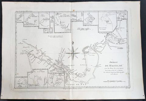
1780 Rigobert Bonne Antique Map of The Straits of Magellan, Chile, South America
- Title : Detroit De Magellan avec les plans des Principaux... Par M. Bonne
- Ref : 40569
- Size: 16in x 11in (405mm x 280mm)
- Date : 1780
- Condition: (A+) Fine Condition
Description:
This fine original copper plate engraved antique map of Straits of Magellan, South America - with 14 inset maps of different bays and inlets of the straits - by Rigobert Bonne was published in the 1780 edition of Atlas des toutes les parties connues du globe terrestre by Guillaume Raynal.
General Definitions:
Paper thickness and quality: - Heavy and stable
Paper color : - off white
Age of map color: -
Colors used: -
General color appearance: -
Paper size: - 16in x 11in (405mm x 280mm)
Plate size: - 14 1/2in x 10 1/2in (370mm x 265mm)
Margins: - Min 1/2in (12mm)
Imperfections:
Margins: - None
Plate area: - wo small worm holes adjacent to bottom centerfold
Verso: - None
Background:
The Strait of Magellan: (Estrecho de Magallanes) is a navigable sea route separating mainland South America to the north and Tierra del Fuego to the south. The strait is the most important natural passage between the Atlantic and Pacific oceans.
Ferdinand Magellan a Portuguese explorer and navigator in the service of Charles I of Spain, became the first European to navigate the strait in 1520 during his circumnavigation of the globe.
Other early explorers included Francis Drake (1578). In February 1696 the first French expedition, under the command of M. de Gennes reached the Strait of Magellan. The expedition is described by the young French explorer, engineer and hydrographer François Froger in his A Relation of a Voyage (1699).
The strait was first carefully explored and thoroughly charted by Phillip Parker King, who commanded the British survey vessel HMS Adventure, and in consort with HMS Beagle spent five years surveying the complex coasts around the strait (1826–1830). A report on the survey was presented at two meetings of the Geographical Society of London in 1831.
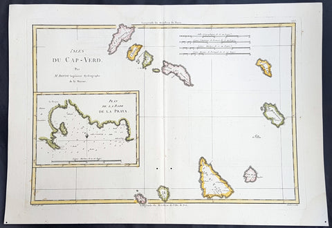
1780 Rigobert Bonne Antique Map of the Cape Verde Islands & Plan of Praia
- Title : Isles Du Cap-Verd; Plan de la Rade de la Praya...Par M Bonne
- Ref : 40546
- Size: 16in x 11in (405mm x 280mm)
- Date : 1780
- Condition: (A+) Fine Condition
Description:
This fine original copper plate engraved antique map of the Cape Verde Islands, West Africa with an inset map of the harbour & city of Praia, by Rigobert Bonne was published in the 1780 edition of Atlas des toutes les parties connues du globe terrestre by Guillaume Raynal.
General Definitions:
Paper thickness and quality: - Heavy and stable
Paper color : - off white
Age of map color: - Early
Colors used: - Yellow, pink, green, blue
General color appearance: - Authentic
Paper size: - 16in x 11in (405mm x 280mm)
Plate size: - 14 1/2in x 10 1/2in (370mm x 265mm)
Margins: - Min 1/2in (12mm)
Imperfections:
Margins: - None
Plate area: - None
Verso: - None
Background:
Cape Verde officially the Republic of Cabo Verde, is an island country spanning an archipelago of 10 volcanic islands in the central Atlantic Ocean. It forms part of the Macaronesia ecoregion, along with the Azores, Canary Islands, Madeira, and the Savage Isles.
The Cape Verde archipelago was uninhabited until the 15th century, when Portuguese explorers discovered and colonized the islands, establishing the first European settlement in the tropics. Ideally located for the Atlantic slave trade, the islands grew prosperous throughout the 16th and 17th centuries, attracting merchants, privateers, and pirates. The end of slavery in the 19th century led to economic decline and emigration. Cape Verde gradually recovered as an important commercial center and stopover for shipping routes. Incorporated as an overseas department of Portugal in 1951, the islands continued to campaign for independence, which was peacefully achieved in 1975.
Praia is the capital and largest city of Cape Verde, an island nation in the Atlantic Ocean west of Senegal. It lies on the southern coast of Santiago island in the Sotavento Islands group.
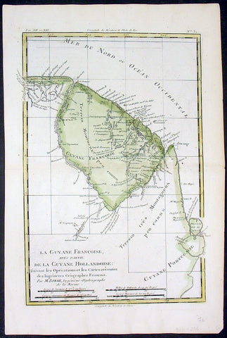
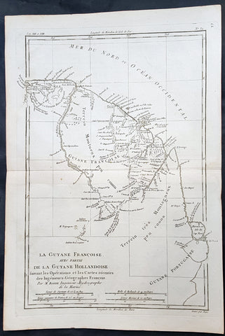
1780 Rigobert Bonne Antique Map of South America French Guiana, Suriname, Guyana
- Title : La Guyane Francoise avec Partie De La Guyane Hollandoise... Par M. Bonne
- Ref #: 16059
- Size: 15in x 10in (385mm x 255mm)
- Date : 1780
- Condition: (A+) Fine Condition
Description:
This fine original copper plate engraved antique map of Guyana, Suriname & French Guiana, South America by Rigobert Bonne was published in the 1780 edition of Atlas des toutes les parties connues du globe terrestre by Guillaume Raynal.
General Definitions:
Paper thickness and quality: - Heavy and stable
Paper color : - off white
Age of map color: - Early
Colors used: - Green, yellow
General color appearance: - Authentic
Paper size: - 15in x 10in (385mm x 255mm)
Plate size: - 13in x 9in (330mm x 230mm)
Margins: - Min 1/2in (12mm)
Imperfections:
Margins: - None
Plate area: - None
Verso: - None
Background:
Guyana officially the Co-operative Republic of Guyana, is a country on the northern mainland of South America. It is, however, often considered part of the Caribbean region because of its strong cultural, historical, and political ties with other Anglo-Caribbean countries and the Caribbean Community.
The region known as the Guianas consists of the large shield landmass north of the Amazon River and east of the Orinoco River known as the \"land of many waters. Originally inhabited by many indigenous groups, Guyana was settled by the Dutch before coming under British control in the late 18th century. It was governed as British Guiana, with a mostly plantation-style economy until the 1950s.
Suriname officially known as the Republic of Suriname is a country on the northeastern Atlantic coast of South America. It is bordered by the Atlantic Ocean to the north, French Guiana to the east, Guyana to the west and Brazil to the south.
Suriname was long inhabited by various indigenous people before being invaded and contested by European powers from the 16th century, eventually coming under Dutch rule in the late 17th century. During the Dutch colonial period, it was primarily a plantation economy dependent on African slaves and, following the abolition of slavery, indentured servants from Asia.
French Guiana is an overseas department and region of France, on the north Atlantic coast of South America in the Guyanas. It borders Brazil to the east and south and Suriname to the west.
Before European contact, the territory was originally inhabited by Native Americans, most speaking the Arawak language, of the Arawakan language family. The people identified as Lokono. The first French establishment is recorded in 1503, but France did not establish a durable presence until colonists founded Cayenne in 1643. Guiana was developed as a slave society, where planters imported Africans as enslaved laborers on large sugar and other plantations in such number as to increase the population. Slavery was abolished in the colonies at the time of the French Revolution. Guiana was designated as a French department in 1797. But, after France gave up its territory in North America, it developed Guiana as a penal colony, establishing a network of camps and penitentiaries along the coast where prisoners from metropolitan France were sentenced to forced labor.
1780 Rigobert Bonne Antique Map of South America Guyana, Suriname, French Guiana
- Title : La Guyane Francoise avec Partie De La Guyane Hollandoise... Par M. Bonne
- Ref #: 16059
- Size: 15in x 10in (385mm x 255mm)
- Date : 1780
- Condition: (A+) Fine Condition
Description:
This fine original copper plate engraved antique map of Guyana, Suriname & French Guiana, South America by Rigobert Bonne was published in the 1780 edition of Atlas des toutes les parties connues du globe terrestre by Guillaume Raynal.
General Definitions:
Paper thickness and quality: - Heavy and stable
Paper color : - off white
Age of map color: -
Colors used: -
General color appearance: -
Paper size: - 15in x 10in (385mm x 255mm)
Plate size: - 13in x 9in (330mm x 230mm)
Margins: - Min 1/2in (12mm)
Imperfections:
Margins: - None
Plate area: - None
Verso: - None
Background:
Guyana officially the Co-operative Republic of Guyana, is a country on the northern mainland of South America. It is, however, often considered part of the Caribbean region because of its strong cultural, historical, and political ties with other Anglo-Caribbean countries and the Caribbean Community.
The region known as the Guianas consists of the large shield landmass north of the Amazon River and east of the Orinoco River known as the \"land of many waters. Originally inhabited by many indigenous groups, Guyana was settled by the Dutch before coming under British control in the late 18th century. It was governed as British Guiana, with a mostly plantation-style economy until the 1950s.
Suriname officially known as the Republic of Suriname is a country on the northeastern Atlantic coast of South America. It is bordered by the Atlantic Ocean to the north, French Guiana to the east, Guyana to the west and Brazil to the south.
Suriname was long inhabited by various indigenous people before being invaded and contested by European powers from the 16th century, eventually coming under Dutch rule in the late 17th century. During the Dutch colonial period, it was primarily a plantation economy dependent on African slaves and, following the abolition of slavery, indentured servants from Asia.
French Guiana is an overseas department and region of France, on the north Atlantic coast of South America in the Guyanas. It borders Brazil to the east and south and Suriname to the west.
Before European contact, the territory was originally inhabited by Native Americans, most speaking the Arawak language, of the Arawakan language family. The people identified as Lokono. The first French establishment is recorded in 1503, but France did not establish a durable presence until colonists founded Cayenne in 1643. Guiana was developed as a slave society, where planters imported Africans as enslaved laborers on large sugar and other plantations in such number as to increase the population. Slavery was abolished in the colonies at the time of the French Revolution. Guiana was designated as a French department in 1797. But, after France gave up its territory in North America, it developed Guiana as a penal colony, establishing a network of camps and penitentiaries along the coast where prisoners from metropolitan France were sentenced to forced labor.
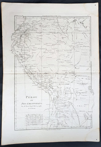
1780 Rigobert Bonne Antique Map of West South America Peru & The Amazon River
- Title : Perou et Pays Circonvoisins... Par M. Bonne
- Ref #: 40551
- Size: 17in x 11 1/2in (430mm x 290mm)
- Date : 1780
- Condition: (A+) Fine Condition
Description:
This fine original copper plate engraved antique map of Peru & the western Amazon River by Rigobert Bonne was published in the 1780 edition of Atlas des toutes les parties connues du globe terrestre by Guillaume Raynal.
General Definitions:
Paper thickness and quality: - Heavy and stable
Paper color : - off white
Age of map color: -
Colors used: -
General color appearance: -
Paper size: - 16in x 11in (410mm x 270mm)
Plate size: - 13in x 9in (330mm x 230mm)
Margins: - Min 1/2in (12mm)
Imperfections:
Margins: - None
Plate area: - None
Verso: - None
Background:
Peru officially the Republic of Peru is a country in western South America. It is bordered in the north by Ecuador and Colombia, in the east by Brazil, in the southeast by Bolivia, in the south by Chile, and in the west by the Pacific Ocean.
Atahualpa (also Atahuallpa), the last Sapa Inca became emperor when he defeated and executed his older half-brother Huáscar in a civil war sparked by the death of their father, Inca Huayna Capac. In December 1532, a party of conquistadors led by Francisco Pizarro defeated and captured the Inca Emperor Atahualpa in the Battle of Cajamarca. The Spanish conquest of the Inca Empire was one of the most important campaigns in the Spanish colonization of the Americas. After years of preliminary exploration and military conflicts, it was the first step in a long campaign that took decades of fighting but ended in Spanish victory and colonization of the region known as the Viceroyalty of Peru with its capital at Lima, which became known as The City of Kings. The conquest of the Inca Empire led to spin-off campaigns throughout the viceroyalty as well as expeditions towards the Amazon Basin as in the case of Spanish efforts to quell Amerindian resistance. The last Inca resistance was suppressed when the Spaniards annihilated the Neo-Inca State in Vilcabamba in 1572.
The indigenous population dramatically collapsed due to exploitation, socioeconomic change and epidemic diseases introduced by the Spanish. Viceroy Francisco de Toledo reorganized the country in the 1570s with gold and silver mining as its main economic activity and Amerindian forced labor as its primary workforce. With the discovery of the great silver and gold lodes at Potosí (present-day Bolivia) and Huancavelica, the viceroyalty flourished as an important provider of mineral resources. Peruvian bullion provided revenue for the Spanish Crown and fueled a complex trade network that extended as far as Europe and the Philippines. Because of lack of available work force, African slaves were added to the labor population. The expansion of a colonial administrative apparatus and bureaucracy paralleled the economic reorganization. With the conquest started the spread of Christianity in South America; most people were forcefully converted to Catholicism, taking only a generation to convert the population. They built churches in every city and replaced some of the Inca temples with churches, such as the Coricancha in the city of Cusco. The church employed the Inquisition, making use of torture to ensure that newly converted Catholics did not stray to other religions or beliefs. Peruvian Catholicism follows the syncretism found in many Latin American countries, in which religious native rituals have been integrated with Christian celebrations. In this endeavor, the church came to play an important role in the acculturation of the natives, drawing them into the cultural orbit of the Spanish settlers.
By the 18th century, declining silver production and economic diversification greatly diminished royal income. In response, the Crown enacted the Bourbon Reforms, a series of edicts that increased taxes and partitioned the Viceroyalty. The new laws provoked Túpac Amaru II\'s rebellion and other revolts, all of which were suppressed. As a result of these and other changes, the Spaniards and their creole successors came to monopolize control over the land, seizing many of the best lands abandoned by the massive native depopulation. However, the Spanish did not resist the Portuguese expansion of Brazil across the meridian. The Treaty of Tordesillas was rendered meaningless between 1580 and 1640 while Spain controlled Portugal. The need to ease communication and trade with Spain led to the split of the viceroyalty and the creation of new viceroyalties of New Granada and Rio de la Plata at the expense of the territories that formed the viceroyalty of Peru; this reduced the power, prominence and importance of Lima as the viceroyal capital and shifted the lucrative Andean trade to Buenos Aires and Bogotá, while the fall of the mining and textile production accelerated the progressive decay of the Viceroyalty of Peru.
Eventually, the viceroyalty would dissolve, as with much of the Spanish empire, when challenged by national independence movements at the beginning of the nineteenth century. These movements led to the formation of the majority of modern-day countries of South America in the territories that at one point or another had constituted the Viceroyalty of Peru. The conquest and colony brought a mix of cultures and ethnicities that did not exist before the Spanish conquered the Peruvian territory. Even though many of the Inca traditions were lost or diluted, new customs, traditions and knowledge were added, creating a rich mixed Peruvian culture. Two of the most important indigenous rebellions against the Spanish were that of Juan Santos Atahualpa in 1742, and Rebellion of Túpac Amaru II in 1780 around the highlands near Cuzco.
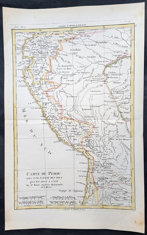
1780 Rigobert Bonne Antique Map of Peru, The Amazon River, South America
- Title : Carte Du Perou avec une partie des pays quien sont al est... Par M. Bonne
- Ref #: 31680
- Size: 16in x 11in (410mm x 270mm)
- Date : 1780
- Condition: (A+) Fine Condition
Description:
This fine original copper plate engraved antique map of Peru & the western Amazon River by Rigobert Bonne was published in the 1780 edition of Atlas des toutes les parties connues du globe terrestre by Guillaume Raynal.
General Definitions:
Paper thickness and quality: - Heavy and stable
Paper color : - off white
Age of map color: - Original
Colors used: - Yellow, green
General color appearance: - Authentic
Paper size: - 16in x 11in (410mm x 270mm)
Plate size: - 13in x 9in (330mm x 230mm)
Margins: - Min 1/2in (12mm)
Imperfections:
Margins: - None
Plate area: - None
Verso: - None
Background:
Peru officially the Republic of Peru is a country in western South America. It is bordered in the north by Ecuador and Colombia, in the east by Brazil, in the southeast by Bolivia, in the south by Chile, and in the west by the Pacific Ocean.
Atahualpa (also Atahuallpa), the last Sapa Inca became emperor when he defeated and executed his older half-brother Huáscar in a civil war sparked by the death of their father, Inca Huayna Capac. In December 1532, a party of conquistadors led by Francisco Pizarro defeated and captured the Inca Emperor Atahualpa in the Battle of Cajamarca. The Spanish conquest of the Inca Empire was one of the most important campaigns in the Spanish colonization of the Americas. After years of preliminary exploration and military conflicts, it was the first step in a long campaign that took decades of fighting but ended in Spanish victory and colonization of the region known as the Viceroyalty of Peru with its capital at Lima, which became known as The City of Kings. The conquest of the Inca Empire led to spin-off campaigns throughout the viceroyalty as well as expeditions towards the Amazon Basin as in the case of Spanish efforts to quell Amerindian resistance. The last Inca resistance was suppressed when the Spaniards annihilated the Neo-Inca State in Vilcabamba in 1572.
The indigenous population dramatically collapsed due to exploitation, socioeconomic change and epidemic diseases introduced by the Spanish. Viceroy Francisco de Toledo reorganized the country in the 1570s with gold and silver mining as its main economic activity and Amerindian forced labor as its primary workforce. With the discovery of the great silver and gold lodes at Potosí (present-day Bolivia) and Huancavelica, the viceroyalty flourished as an important provider of mineral resources. Peruvian bullion provided revenue for the Spanish Crown and fueled a complex trade network that extended as far as Europe and the Philippines. Because of lack of available work force, African slaves were added to the labor population. The expansion of a colonial administrative apparatus and bureaucracy paralleled the economic reorganization. With the conquest started the spread of Christianity in South America; most people were forcefully converted to Catholicism, taking only a generation to convert the population. They built churches in every city and replaced some of the Inca temples with churches, such as the Coricancha in the city of Cusco. The church employed the Inquisition, making use of torture to ensure that newly converted Catholics did not stray to other religions or beliefs. Peruvian Catholicism follows the syncretism found in many Latin American countries, in which religious native rituals have been integrated with Christian celebrations. In this endeavor, the church came to play an important role in the acculturation of the natives, drawing them into the cultural orbit of the Spanish settlers.
By the 18th century, declining silver production and economic diversification greatly diminished royal income. In response, the Crown enacted the Bourbon Reforms, a series of edicts that increased taxes and partitioned the Viceroyalty. The new laws provoked Túpac Amaru II\'s rebellion and other revolts, all of which were suppressed. As a result of these and other changes, the Spaniards and their creole successors came to monopolize control over the land, seizing many of the best lands abandoned by the massive native depopulation. However, the Spanish did not resist the Portuguese expansion of Brazil across the meridian. The Treaty of Tordesillas was rendered meaningless between 1580 and 1640 while Spain controlled Portugal. The need to ease communication and trade with Spain led to the split of the viceroyalty and the creation of new viceroyalties of New Granada and Rio de la Plata at the expense of the territories that formed the viceroyalty of Peru; this reduced the power, prominence and importance of Lima as the viceroyal capital and shifted the lucrative Andean trade to Buenos Aires and Bogotá, while the fall of the mining and textile production accelerated the progressive decay of the Viceroyalty of Peru.
Eventually, the viceroyalty would dissolve, as with much of the Spanish empire, when challenged by national independence movements at the beginning of the nineteenth century. These movements led to the formation of the majority of modern-day countries of South America in the territories that at one point or another had constituted the Viceroyalty of Peru. The conquest and colony brought a mix of cultures and ethnicities that did not exist before the Spanish conquered the Peruvian territory. Even though many of the Inca traditions were lost or diluted, new customs, traditions and knowledge were added, creating a rich mixed Peruvian culture. Two of the most important indigenous rebellions against the Spanish were that of Juan Santos Atahualpa in 1742, and Rebellion of Túpac Amaru II in 1780 around the highlands near Cuzco.
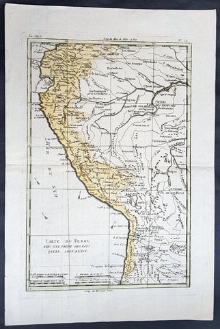
1780 Rigobert Bonne Antique Map of Peru, The Amazon River, South America
- Title : Carte Du Perou avec une partie des pays quien sont al est... Par M. Bonne
- Ref #: 60565
- Size: 16in x 11in (410mm x 270mm)
- Date : 1780
- Condition: (A+) Fine Condition
Description:
This fine original copper plate engraved antique map of Peru & the western Amazon River by Rigobert Bonne was published in the 1780 edition of Atlas des toutes les parties connues du globe terrestre by Guillaume Raynal.
General Definitions:
Paper thickness and quality: - Heavy and stable
Paper color : - off white
Age of map color: - Original
Colors used: - Yellow, green
General color appearance: - Authentic
Paper size: - 16in x 11in (410mm x 270mm)
Plate size: - 13in x 9in (330mm x 230mm)
Margins: - Min 1/2in (12mm)
Imperfections:
Margins: - None
Plate area: - None
Verso: - None
Background:
Peru officially the Republic of Peru is a country in western South America. It is bordered in the north by Ecuador and Colombia, in the east by Brazil, in the southeast by Bolivia, in the south by Chile, and in the west by the Pacific Ocean.
Atahualpa (also Atahuallpa), the last Sapa Inca became emperor when he defeated and executed his older half-brother Huáscar in a civil war sparked by the death of their father, Inca Huayna Capac. In December 1532, a party of conquistadors led by Francisco Pizarro defeated and captured the Inca Emperor Atahualpa in the Battle of Cajamarca. The Spanish conquest of the Inca Empire was one of the most important campaigns in the Spanish colonization of the Americas. After years of preliminary exploration and military conflicts, it was the first step in a long campaign that took decades of fighting but ended in Spanish victory and colonization of the region known as the Viceroyalty of Peru with its capital at Lima, which became known as The City of Kings. The conquest of the Inca Empire led to spin-off campaigns throughout the viceroyalty as well as expeditions towards the Amazon Basin as in the case of Spanish efforts to quell Amerindian resistance. The last Inca resistance was suppressed when the Spaniards annihilated the Neo-Inca State in Vilcabamba in 1572.
The indigenous population dramatically collapsed due to exploitation, socioeconomic change and epidemic diseases introduced by the Spanish. Viceroy Francisco de Toledo reorganized the country in the 1570s with gold and silver mining as its main economic activity and Amerindian forced labor as its primary workforce. With the discovery of the great silver and gold lodes at Potosí (present-day Bolivia) and Huancavelica, the viceroyalty flourished as an important provider of mineral resources. Peruvian bullion provided revenue for the Spanish Crown and fueled a complex trade network that extended as far as Europe and the Philippines. Because of lack of available work force, African slaves were added to the labor population. The expansion of a colonial administrative apparatus and bureaucracy paralleled the economic reorganization. With the conquest started the spread of Christianity in South America; most people were forcefully converted to Catholicism, taking only a generation to convert the population. They built churches in every city and replaced some of the Inca temples with churches, such as the Coricancha in the city of Cusco. The church employed the Inquisition, making use of torture to ensure that newly converted Catholics did not stray to other religions or beliefs. Peruvian Catholicism follows the syncretism found in many Latin American countries, in which religious native rituals have been integrated with Christian celebrations. In this endeavor, the church came to play an important role in the acculturation of the natives, drawing them into the cultural orbit of the Spanish settlers.
By the 18th century, declining silver production and economic diversification greatly diminished royal income. In response, the Crown enacted the Bourbon Reforms, a series of edicts that increased taxes and partitioned the Viceroyalty. The new laws provoked Túpac Amaru II\'s rebellion and other revolts, all of which were suppressed. As a result of these and other changes, the Spaniards and their creole successors came to monopolize control over the land, seizing many of the best lands abandoned by the massive native depopulation. However, the Spanish did not resist the Portuguese expansion of Brazil across the meridian. The Treaty of Tordesillas was rendered meaningless between 1580 and 1640 while Spain controlled Portugal. The need to ease communication and trade with Spain led to the split of the viceroyalty and the creation of new viceroyalties of New Granada and Rio de la Plata at the expense of the territories that formed the viceroyalty of Peru; this reduced the power, prominence and importance of Lima as the viceroyal capital and shifted the lucrative Andean trade to Buenos Aires and Bogotá, while the fall of the mining and textile production accelerated the progressive decay of the Viceroyalty of Peru.
Eventually, the viceroyalty would dissolve, as with much of the Spanish empire, when challenged by national independence movements at the beginning of the nineteenth century. These movements led to the formation of the majority of modern-day countries of South America in the territories that at one point or another had constituted the Viceroyalty of Peru. The conquest and colony brought a mix of cultures and ethnicities that did not exist before the Spanish conquered the Peruvian territory. Even though many of the Inca traditions were lost or diluted, new customs, traditions and knowledge were added, creating a rich mixed Peruvian culture. Two of the most important indigenous rebellions against the Spanish were that of Juan Santos Atahualpa in 1742, and Rebellion of Túpac Amaru II in 1780 around the highlands near Cuzco.
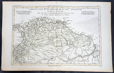
1780 Rigobert Bonne Antique Map South America Colombia, Venezuela, Amazon River
- Title : Carte Du Nouv. Rme. De Grenade de la Noule. Andalousie et de la Guyane... Par M. Bonne
- Ref #: 31681
- Size: 16in x 11in (410mm x 270mm)
- Date : 1780
- Condition: (A+) Fine Condition
Description:
This fine original copper plate engraved antique map of Northern South America from Colombia to Venezuela, The Guyanas, Brazil & The Amazon River by Rigobert Bonne was published in the 1780 edition of Atlas des toutes les parties connues du globe terrestre by Guillaume Raynal.
General Definitions:
Paper thickness and quality: - Heavy and stable
Paper color : - off white
Age of map color: - Early
Colors used: - Green, Yellow
General color appearance: - Authentic
Paper size: - 16in x 11in (410mm x 270mm)
Plate size: - 14 1/2in x 10in (370mm x 255mm)
Margins: - Min 1/2in (12mm)
Imperfections:
Margins: - None
Plate area: - None
Verso: - None
Background:
In 1494, Portugal and Spain, the two great maritime European powers of that time, on the expectation of new lands being discovered in the west, signed the Treaty of Tordesillas, by which they agreed, with the support of the Pope, that all the land outside Europe should be an exclusive duopoly between the two countries.
The treaty established an imaginary line along a north-south meridian 370 leagues west of the Cape Verde Islands, roughly 46° 37\\\\\\\\\\\\\\\' W. In terms of the treaty, all land to the west of the line (known to comprise most of the South American soil) would belong to Spain, and all land to the east, to Portugal. As accurate measurements of longitude were impossible at that time, the line was not strictly enforced, resulting in a Portuguese expansion of Brazil across the meridian.
Beginning in the 1530s, the people and natural resources of South America were repeatedly exploited by foreign conquistadors, first from Spain and later from Portugal. These competing colonial nations claimed the land and resources as their own and divided it in colonies.
European infectious diseases (smallpox, influenza, measles, and typhus) – to which the native populations had no immune resistance – caused large-scale depopulation of the native population under Spanish control. Systems of forced labor, such as the haciendas and mining industry\\\\\\\\\\\\\\\'s mita also contributed to the depopulation. After this, African slaves, who had developed immunities to these diseases, were quickly brought in to replace them.
The Spaniards were committed to converting their native subjects to Christianity and were quick to purge any native cultural practices that hindered this end; however, many initial attempts at this were only partially successful, as native groups simply blended Catholicism with their established beliefs and practices. Furthermore, the Spaniards brought their language to the degree they did with their religion, although the Roman Catholic Churchs evangelization in Quechua, Aymara, and Guaraní actually contributed to the continuous use of these native languages albeit only in the oral form.
Eventually, the natives and the Spaniards interbred, forming a mestizo class. At the beginning, many mestizos of the Andean region were offspring of Amerindian mothers and Spanish fathers. After independence, most mestizos had native fathers and European or mestizo mothers.
Many native artworks were considered pagan idols and destroyed by Spanish explorers; this included many gold and silver sculptures and other artifacts found in South America, which were melted down before their transport to Spain or Portugal. Spaniards and Portuguese brought the western European architectural style to the continent, and helped to improve infrastructures like bridges, roads, and the sewer system of the cities they discovered or conquered. They also significantly increased economic and trade relations, not just between the old and new world but between the different South American regions and peoples. Finally, with the expansion of the Portuguese and Spanish languages, many cultures that were previously separated became united through that of Latin American.
Guyana was first a Dutch, and then a British colony, though there was a brief period during the Napoleonic Wars when it was colonized by the French. The country was once partitioned into three parts, each being controlled by one of the colonial powers until the country was finally taken over fully by the British.
The European Peninsular War (1807–1814), a theater of the Napoleonic Wars, changed the political situation of both the Spanish and Portuguese colonies. First, Napoleon invaded Portugal, but the House of Braganza avoided capture by escaping to Brazil. Napoleon also captured King Ferdinand VII of Spain, and appointed his own brother instead. This appointment provoked severe popular resistance, which created Juntas to rule in the name of the captured king.
Many cities in the Spanish colonies, however, considered themselves equally authorized to appoint local Juntas like those of Spain. This began the Spanish American wars of independence between the patriots, who promoted such autonomy, and the royalists, who supported Spanish authority over the Americas. The Juntas, in both Spain and the Americas, promoted the ideas of the Enlightenment. Five years after the beginning of the war, Ferdinand VII returned to the throne and began the Absolutist Restoration as the royalists got the upper hand in the conflict.
The independence of South America was secured by Simón Bolívar (Venezuela) and José de San Martín (Argentina), the two most important Libertadores. Bolívar led a great uprising in the north, then led his army southward towards Lima, the capital of the Viceroyalty of Peru. Meanwhile, San Martín led an army across the Andes Mountains, along with Chilean expatriates, and liberated Chile. He organized a fleet to reach Peru by sea, and sought the military support of various rebels from the Vice-royalty of Peru. The two armies finally met in Guayaquil, Ecuador, where they cornered the Royal Army of the Spanish Crown and forced its surrender.
In the Portuguese Kingdom of Brazil, Dom Pedro I (also Pedro IV of Portugal), son of the Portuguese King Dom João VI, proclaimed the independent Kingdom of Brazil in 1822, which later became the Empire of Brazil. Despite the Portuguese loyalties of garrisons in Bahia, Cisplatina and Pará, independence was diplomatically accepted by the crown in Portugal in 1825, on condition of a high compensation paid by Brazil mediatized by the United Kingdom.
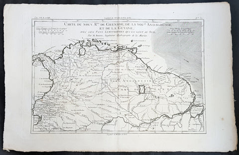
1780 Rigobert Bonne Antique Map South America Colombia, Venezuela, Amazon River
- Title : Carte Du Nouv. Rme. De Grenade de la Noule. Andalousie et de la Guyane... Par M. Bonne
- Ref #: 40848
- Size: 16in x 11in (410mm x 270mm)
- Date : 1780
- Condition: (A+) Fine Condition
Description:
This fine original copper plate engraved antique map of Northern South America from Colombia to Venezuela, The Guyanas, Brazil & The Amazon River by Rigobert Bonne was published in the 1780 edition of Atlas des toutes les parties connues du globe terrestre by Guillaume Raynal.
General Definitions:
Paper thickness and quality: - Heavy and stable
Paper color : - off white
Age of map color: -
Colors used: -
General color appearance: -
Paper size: - 16in x 11in (410mm x 270mm)
Plate size: - 14 1/2in x 10in (370mm x 255mm)
Margins: - Min 1/2in (12mm)
Imperfections:
Margins: - None
Plate area: - None
Verso: - None
Background:
In 1494, Portugal and Spain, the two great maritime European powers of that time, on the expectation of new lands being discovered in the west, signed the Treaty of Tordesillas, by which they agreed, with the support of the Pope, that all the land outside Europe should be an exclusive duopoly between the two countries.
The treaty established an imaginary line along a north-south meridian 370 leagues west of the Cape Verde Islands, roughly 46° 37\\\\\\\\\\\\\\\' W. In terms of the treaty, all land to the west of the line (known to comprise most of the South American soil) would belong to Spain, and all land to the east, to Portugal. As accurate measurements of longitude were impossible at that time, the line was not strictly enforced, resulting in a Portuguese expansion of Brazil across the meridian.
Beginning in the 1530s, the people and natural resources of South America were repeatedly exploited by foreign conquistadors, first from Spain and later from Portugal. These competing colonial nations claimed the land and resources as their own and divided it in colonies.
European infectious diseases (smallpox, influenza, measles, and typhus) – to which the native populations had no immune resistance – caused large-scale depopulation of the native population under Spanish control. Systems of forced labor, such as the haciendas and mining industry\\\\\\\\\\\\\\\'s mita also contributed to the depopulation. After this, African slaves, who had developed immunities to these diseases, were quickly brought in to replace them.
The Spaniards were committed to converting their native subjects to Christianity and were quick to purge any native cultural practices that hindered this end; however, many initial attempts at this were only partially successful, as native groups simply blended Catholicism with their established beliefs and practices. Furthermore, the Spaniards brought their language to the degree they did with their religion, although the Roman Catholic Churchs evangelization in Quechua, Aymara, and Guaraní actually contributed to the continuous use of these native languages albeit only in the oral form.
Eventually, the natives and the Spaniards interbred, forming a mestizo class. At the beginning, many mestizos of the Andean region were offspring of Amerindian mothers and Spanish fathers. After independence, most mestizos had native fathers and European or mestizo mothers.
Many native artworks were considered pagan idols and destroyed by Spanish explorers; this included many gold and silver sculptures and other artifacts found in South America, which were melted down before their transport to Spain or Portugal. Spaniards and Portuguese brought the western European architectural style to the continent, and helped to improve infrastructures like bridges, roads, and the sewer system of the cities they discovered or conquered. They also significantly increased economic and trade relations, not just between the old and new world but between the different South American regions and peoples. Finally, with the expansion of the Portuguese and Spanish languages, many cultures that were previously separated became united through that of Latin American.
Guyana was first a Dutch, and then a British colony, though there was a brief period during the Napoleonic Wars when it was colonized by the French. The country was once partitioned into three parts, each being controlled by one of the colonial powers until the country was finally taken over fully by the British.
The European Peninsular War (1807–1814), a theater of the Napoleonic Wars, changed the political situation of both the Spanish and Portuguese colonies. First, Napoleon invaded Portugal, but the House of Braganza avoided capture by escaping to Brazil. Napoleon also captured King Ferdinand VII of Spain, and appointed his own brother instead. This appointment provoked severe popular resistance, which created Juntas to rule in the name of the captured king.
Many cities in the Spanish colonies, however, considered themselves equally authorized to appoint local Juntas like those of Spain. This began the Spanish American wars of independence between the patriots, who promoted such autonomy, and the royalists, who supported Spanish authority over the Americas. The Juntas, in both Spain and the Americas, promoted the ideas of the Enlightenment. Five years after the beginning of the war, Ferdinand VII returned to the throne and began the Absolutist Restoration as the royalists got the upper hand in the conflict.
The independence of South America was secured by Simón Bolívar (Venezuela) and José de San Martín (Argentina), the two most important Libertadores. Bolívar led a great uprising in the north, then led his army southward towards Lima, the capital of the Viceroyalty of Peru. Meanwhile, San Martín led an army across the Andes Mountains, along with Chilean expatriates, and liberated Chile. He organized a fleet to reach Peru by sea, and sought the military support of various rebels from the Vice-royalty of Peru. The two armies finally met in Guayaquil, Ecuador, where they cornered the Royal Army of the Spanish Crown and forced its surrender.
In the Portuguese Kingdom of Brazil, Dom Pedro I (also Pedro IV of Portugal), son of the Portuguese King Dom João VI, proclaimed the independent Kingdom of Brazil in 1822, which later became the Empire of Brazil. Despite the Portuguese loyalties of garrisons in Bahia, Cisplatina and Pará, independence was diplomatically accepted by the crown in Portugal in 1825, on condition of a high compensation paid by Brazil mediatized by the United Kingdom.
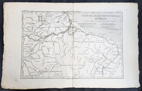
1780 Rigobert Bonne Antique Map of Northern Brazil, French Guiana, Amazon River
- Title : Carte De La Partie Septentrionale Du Bresil... Par M. Bonne
- Ref #: 40850
- Size: 17in x 11in (435mm x 280mm)
- Date : 1780
- Condition: (A+) Fine Condition
Description:
This fine original copper plate engraved antique map of Northern Brazil, French Guiana & The Amazon River by Rigobert Bonne was published in the 1780 edition of Atlas des toutes les parties connues du globe terrestre by Guillaume Raynal.
General Definitions:
Paper thickness and quality: - Heavy and stable
Paper color : - off white
Age of map color: -
Colors used: -
General color appearance: -
Paper size: - 17in x 11in (435mm x 280mm)
Plate size: - 13 1/2in x 9in (345mm x 230mm)
Margins: - Min 1/2in (12mm)
Imperfections:
Margins: - None
Plate area: - None
Verso: - None
Background:
Brazil is the largest country in both South America and Latin America. At 8.5 million square kilometers.
Brazil was inhabited by numerous tribal nations prior to the landing in 1500 of explorer Pedro Álvares Cabral, who claimed the area for the Portuguese Empire. Brazil remained a Portuguese colony until 1808, when the capital of the empire was transferred from Lisbon to Rio de Janeiro. In 1815, the colony was elevated to the rank of kingdom upon the formation of the United Kingdom of Portugal, Brazil and the Algarves. Independence was achieved in 1822 with the creation of the Empire of Brazil, a unitary state governed under a constitutional monarchy and a parliamentary system. The ratification of the first constitution in 1824 led to the formation of a bicameral legislature, now called the National Congress. The country became a presidential republic in 1889 following a military coup d état.
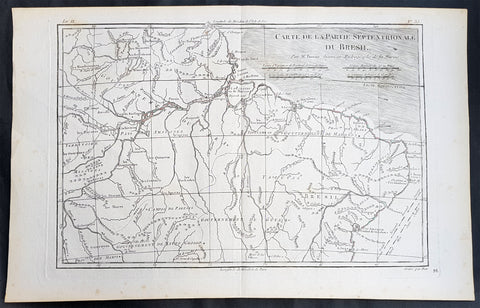
1780 Rigobert Bonne Antique Map of Northern Brazil, French Guiana, Amazon River
- Title : Carte De La Partie Septentrionale Du Bresil... Par M. Bonne
- Ref #: 31685
- Size: 16in x 10in (410mm x 255mm)
- Date : 1780
- Condition: (A+) Fine Condition
Description:
This fine original copper plate engraved antique map of Northern Brazil, French Guiana & The Amazon River by Rigobert Bonne was published in the 1780 edition of Atlas des toutes les parties connues du globe terrestre by Guillaume Raynal.
General Definitions:
Paper thickness and quality: - Heavy and stable
Paper color : - off white
Age of map color: -
Colors used: -
General color appearance: -
Paper size: - 16in x 10in (410mm x 255mm)
Plate size: - 13 1/2in x 9in (345mm x 230mm)
Margins: - Min 1/2in (12mm)
Imperfections:
Margins: - None
Plate area: - None
Verso: - None
Background:
Brazil is the largest country in both South America and Latin America. At 8.5 million square kilometers.
Brazil was inhabited by numerous tribal nations prior to the landing in 1500 of explorer Pedro Álvares Cabral, who claimed the area for the Portuguese Empire. Brazil remained a Portuguese colony until 1808, when the capital of the empire was transferred from Lisbon to Rio de Janeiro. In 1815, the colony was elevated to the rank of kingdom upon the formation of the United Kingdom of Portugal, Brazil and the Algarves. Independence was achieved in 1822 with the creation of the Empire of Brazil, a unitary state governed under a constitutional monarchy and a parliamentary system. The ratification of the first constitution in 1824 led to the formation of a bicameral legislature, now called the National Congress. The country became a presidential republic in 1889 following a military coup d état.
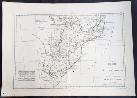
1780 Rigobert Bonne Antique Map Southern Brazil, Uruguay, River Plate Argentina
- Title : Carte De La Parties Meridionale Du Bresil...Par M Bonne
- Ref #: 40552
- Size: 17in x 11in (435mm x 280mm)
- Date : 1780
- Condition: (A+) Fine Condition
Description:
This fine original copper plate engraved antique map of southern Brazil, Uraguay to the Rio De la Plata in Argentina by Rigobert Bonne was published in the 1780 edition of Atlas des toutes les parties connues du globe terrestre by Guillaume Raynal.
General Definitions:
Paper thickness and quality: - Heavy and stable
Paper color : - off white
Age of map color: -
Colors used: -
General color appearance: -
Paper size: - 17in x 11in (435mm x 280mm)
Plate size: - 14in x 9in (355mm x 230mm)
Margins: - Min 1/2in (12mm)
Imperfections:
Margins: - None
Plate area: - None
Verso: - None
Background:
The Río de la Plata River Plate is the estuary formed by the confluence of the Uruguay and the Paraná rivers. It empties into the Atlantic Ocean, forming a funnel-shaped indentation on the southeastern coastline of South America. Depending on the geographer, the Río de la Plata may be considered a river, an estuary, a gulf or a marginal sea.
The Río de la Plata was first explored by the Portuguese in 1512–13. The Spanish first explored it in 1516, when the navigator Juan Díaz de Solís traversed it during his search for a passage between the Atlantic and the Pacific Oceans, calling it the Mar Dulce, or freshwater sea. The Portuguese navigator Ferdinand Magellan briefly explored the estuary in 1520 before his expedition continued its circumnavigation, and in 1521 Cristóvão Jacques also explored the Plate River estuary and ascended the Parana River for the first time, entering it for about 23 leagues (around 140 km) to near the present city of Rosario. The area was also visited by Francis Drakes fleet in early 1578, in the early stages of his circumnavigation.
Explorer Sebastian Cabot made a detailed study of the river and its tributaries and gave it its modern name. He explored the Paraná and Uruguay rivers between 1526 and 1529, ascending the Paraná as far as the present-day city of Asunción, and also explored up the Paraguay River. Cabot acquired silver trinkets trading with the Guaraní near todays Asunción, and these objects (together with legends of a Sierra de la Plata in the South American interior brought back by earlier explorers) inspired him to rename the river Río de la Plata (River of Silver).
The first European colony was the city of Buenos Aires, founded by Pedro de Mendoza on 2 February 1536. This settlement, however, was quickly abandoned; the failure to establish a settlement on the estuary led to explorations upriver and the founding of Asunción in 1537. Buenos Aires was subsequently refounded by Juan de Garay on 11 June 1580.
During the colonial era the Río de la Plata was made the center of the Governorate of the Río de la Plata, but the region\'s development was largely neglected by the Spanish Empire until the 1760s, when Portugal and Britain threatened to expand into the estuary. The governorate was elevated to form the Viceroyalty of the Río de la Plata in 1776. In 1806 and 1807 the river was the scene of an important British invasion that aimed to occupy the area.
Conflict in the region intensified after the independence of the former Spanish and Portuguese colonies in the first quarter of the 19th century. Interests in the territories and the navigation rights over the Platine region played a major role in many armed conflicts throughout the century, including the Argentine civil wars, the Cisplatine and Platine wars, and the Paraguayan War. The river was blockaded by extra-regional powers 1838–1840 and 1845–1850.
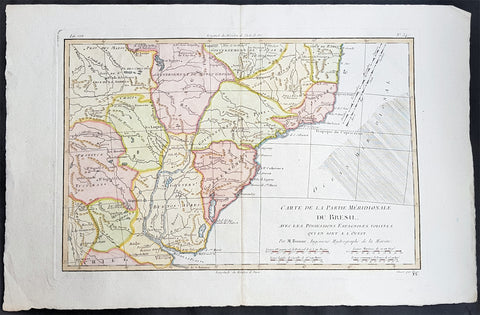
1780 Rigobert Bonne Antique Map Southern Brazil, Uruguay, River Plate Argentina
- Title : Carte De La Parties Meridionale Du Bresil...Par M Bonne
- Ref #: 16042-1
- Size: 17in x 11in (435mm x 280mm)
- Date : 1780
- Condition: (A+) Fine Condition
Description:
This fine original copper plate engraved antique map of southern Brazil, Uraguay to the Rio De la Plata in Argentina by Rigobert Bonne was published in the 1780 edition of Atlas des toutes les parties connues du globe terrestre by Guillaume Raynal.
General Definitions:
Paper thickness and quality: - Heavy and stable
Paper color : - off white
Age of map color: - Early
Colors used: - Yellow, Green, pink
General color appearance: - Authentic
Paper size: - 17in x 11in (435mm x 280mm)
Plate size: - 14in x 9in (355mm x 230mm)
Margins: - Min 1/2in (12mm)
Imperfections:
Margins: - None
Plate area: - None
Verso: - None
Background:
The Río de la Plata River Plate is the estuary formed by the confluence of the Uruguay and the Paraná rivers. It empties into the Atlantic Ocean, forming a funnel-shaped indentation on the southeastern coastline of South America. Depending on the geographer, the Río de la Plata may be considered a river, an estuary, a gulf or a marginal sea.
The Río de la Plata was first explored by the Portuguese in 1512–13. The Spanish first explored it in 1516, when the navigator Juan Díaz de Solís traversed it during his search for a passage between the Atlantic and the Pacific Oceans, calling it the Mar Dulce, or freshwater sea. The Portuguese navigator Ferdinand Magellan briefly explored the estuary in 1520 before his expedition continued its circumnavigation, and in 1521 Cristóvão Jacques also explored the Plate River estuary and ascended the Parana River for the first time, entering it for about 23 leagues (around 140 km) to near the present city of Rosario. The area was also visited by Francis Drakes fleet in early 1578, in the early stages of his circumnavigation.
Explorer Sebastian Cabot made a detailed study of the river and its tributaries and gave it its modern name. He explored the Paraná and Uruguay rivers between 1526 and 1529, ascending the Paraná as far as the present-day city of Asunción, and also explored up the Paraguay River. Cabot acquired silver trinkets trading with the Guaraní near todays Asunción, and these objects (together with legends of a Sierra de la Plata in the South American interior brought back by earlier explorers) inspired him to rename the river Río de la Plata (River of Silver).
The first European colony was the city of Buenos Aires, founded by Pedro de Mendoza on 2 February 1536. This settlement, however, was quickly abandoned; the failure to establish a settlement on the estuary led to explorations upriver and the founding of Asunción in 1537. Buenos Aires was subsequently refounded by Juan de Garay on 11 June 1580.
During the colonial era the Río de la Plata was made the center of the Governorate of the Río de la Plata, but the region\'s development was largely neglected by the Spanish Empire until the 1760s, when Portugal and Britain threatened to expand into the estuary. The governorate was elevated to form the Viceroyalty of the Río de la Plata in 1776. In 1806 and 1807 the river was the scene of an important British invasion that aimed to occupy the area.
Conflict in the region intensified after the independence of the former Spanish and Portuguese colonies in the first quarter of the 19th century. Interests in the territories and the navigation rights over the Platine region played a major role in many armed conflicts throughout the century, including the Argentine civil wars, the Cisplatine and Platine wars, and the Paraguayan War. The river was blockaded by extra-regional powers 1838–1840 and 1845–1850.
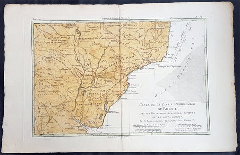
1780 Rigobert Bonne Antique Map Southern Brazil, Uruguay, River Plate Argentina
- Title : Carte De La Parties Meridionale Du Bresil...Par M Bonne
- Ref #: 40851
- Size: 17in x 11in (435mm x 280mm)
- Date : 1780
- Condition: (A+) Fine Condition
Description:
This fine original copper plate engraved antique map of southern Brazil, Uraguay to the Rio De la Plata in Argentina by Rigobert Bonne was published in the 1780 edition of Atlas des toutes les parties connues du globe terrestre by Guillaume Raynal.
General Definitions:
Paper thickness and quality: - Heavy and stable
Paper color : - off white
Age of map color: - Early
Colors used: - Yellow, Green, pink
General color appearance: - Authentic
Paper size: - 17in x 11in (435mm x 280mm)
Plate size: - 14in x 9in (355mm x 230mm)
Margins: - Min 1/2in (12mm)
Imperfections:
Margins: - None
Plate area: - None
Verso: - None
Background:
The Río de la Plata River Plate is the estuary formed by the confluence of the Uruguay and the Paraná rivers. It empties into the Atlantic Ocean, forming a funnel-shaped indentation on the southeastern coastline of South America. Depending on the geographer, the Río de la Plata may be considered a river, an estuary, a gulf or a marginal sea.
The Río de la Plata was first explored by the Portuguese in 1512–13. The Spanish first explored it in 1516, when the navigator Juan Díaz de Solís traversed it during his search for a passage between the Atlantic and the Pacific Oceans, calling it the Mar Dulce, or freshwater sea. The Portuguese navigator Ferdinand Magellan briefly explored the estuary in 1520 before his expedition continued its circumnavigation, and in 1521 Cristóvão Jacques also explored the Plate River estuary and ascended the Parana River for the first time, entering it for about 23 leagues (around 140 km) to near the present city of Rosario. The area was also visited by Francis Drakes fleet in early 1578, in the early stages of his circumnavigation.
Explorer Sebastian Cabot made a detailed study of the river and its tributaries and gave it its modern name. He explored the Paraná and Uruguay rivers between 1526 and 1529, ascending the Paraná as far as the present-day city of Asunción, and also explored up the Paraguay River. Cabot acquired silver trinkets trading with the Guaraní near todays Asunción, and these objects (together with legends of a Sierra de la Plata in the South American interior brought back by earlier explorers) inspired him to rename the river Río de la Plata (River of Silver).
The first European colony was the city of Buenos Aires, founded by Pedro de Mendoza on 2 February 1536. This settlement, however, was quickly abandoned; the failure to establish a settlement on the estuary led to explorations upriver and the founding of Asunción in 1537. Buenos Aires was subsequently refounded by Juan de Garay on 11 June 1580.
During the colonial era the Río de la Plata was made the center of the Governorate of the Río de la Plata, but the region\'s development was largely neglected by the Spanish Empire until the 1760s, when Portugal and Britain threatened to expand into the estuary. The governorate was elevated to form the Viceroyalty of the Río de la Plata in 1776. In 1806 and 1807 the river was the scene of an important British invasion that aimed to occupy the area.
Conflict in the region intensified after the independence of the former Spanish and Portuguese colonies in the first quarter of the 19th century. Interests in the territories and the navigation rights over the Platine region played a major role in many armed conflicts throughout the century, including the Argentine civil wars, the Cisplatine and Platine wars, and the Paraguayan War. The river was blockaded by extra-regional powers 1838–1840 and 1845–1850.

1780 Rigobert Bonne Antique Map of Caribbean Islands of Guadeloupe & Martinique
- Title : L Isle De La Martinique; Isles De La Guadeloupe...Par M Bonne
- Date : 1780
- Size: 15 1/2in x 10in (395mm x 255mm)
- Ref #: 40556
- Condition: (A+) Fine Condition
Description:
This fine original copper plate engraved antique map of Caribbean Islands of Guadeloupe & Martinique by Rigobert Bonne was published in the 1780 edition of Atlas des toutes les parties connues du globe terrestre by Guillaume Raynal.
General Definitions:
Paper thickness and quality: - Heavy and stable
Paper color : - off white
Age of map color: - Early
Colors used: - Yellow, Green, pink
General color appearance: - Authentic
Paper size: - 15 1/2in x 10in (395mm x 255mm)
Plate size: - 13in x 9in (330mm x 230mm)
Margins: - Min 1/2in (12mm)
Imperfections:
Margins: - Two small worm holes
Plate area: - Two small worm holes
Verso: - Two small worm holes
Background:
Martinique is an insular region of France located in the Lesser Antilles of the West Indies in the eastern Caribbean Sea.
Guadeloupe is an insular region of France located in the Leeward Islands, part of the Lesser Antilles in the Caribbean.
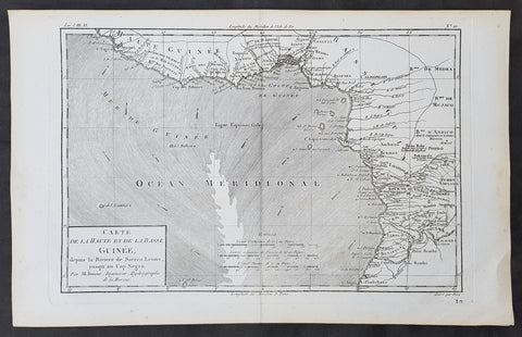
1780 Rigobert Bonne Original Antique Map Gulf of Guinea Africa Liberia to Angola
- Title : Carte de la Haute et de la Basse Guinee...M Bonne
- Size: 15in x 10in (390mm x 255mm)
- Ref #: 31659
- Date : 1780
- Condition: (A+) Fine Condition
Description:
This original copper-plate engraved map was published in 1780 edition of Atllas des toutes les parties connues du globe terrestre by Rigobert Bonne & Guillaume Raynal.
General Definitions:
Paper thickness and quality: - Heavy and stable
Paper color : - off white
Age of map color: -
Colors used: -
General color appearance: -
Paper size: - 15in x 10in (390mm x 255mm)
Plate size: - 13in x 9in (330mm x 235mm)
Margins: - Min 1/4in (8mm)
Imperfections:
Margins: - None
Plate area: - None
Verso: - None
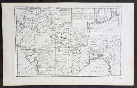
1780 R. Bonne Original Antique Map of Mogul Empire, India, Tibet, Tibet & Ganges
- Title : Carte de la Partie superieure D L Inde en Daca du Gange...M Bonne
- Size: 15in x 10in (380mm x 255mm)
- Ref #: 31661
- Date : 1780
- Condition: (A+) Fine Condition
Description:
This original copper-plate engraved map was published in 1780 edition of Atllas des toutes les parties connues du globe terrestre by Rigobert Bonne & Guillaume Raynal.
General Definitions:
Paper thickness and quality: - Heavy and stable
Paper color : - off white
Age of map color: -
Colors used: -
General color appearance: -
Paper size: - 15in x 10in (380mm x 255mm)
Plate size: - 13in x 9in (330mm x 230mm)
Margins: - Min 1in (25mm)
Imperfections:
Margins: - None
Plate area: - None
Verso: - None
1780 Rigobert Bonne Original Antique Map of The Russian Empire
- Title : Carte De L Empire de Russie en Europe et en Asie...M Bonne
- Size: 15in x 10in (380mm x 255mm)
- Ref #: 31674
- Date : 1780
- Condition: (A+) Fine Condition
Description:
This original copper-plate engraved map was published in 1780 edition of Atllas des toutes les parties connues du globe terrestre by Rigobert Bonne & Guillaume Raynal.
General Definitions:
Paper thickness and quality: - Heavy and stable
Paper color : - off white
Age of map color: -
Colors used: -
General color appearance: -
Paper size: - 15in x 10in (380mm x 255mm)
Plate size: - 13in x 9in (330mm x 230mm)
Margins: - Min 1in (25mm)
Imperfections:
Margins: - None
Plate area: - None
Verso: - None
1780 Rigobert Bonne Original Antique Map of Turkey in Asia - Black Sea to Persia
- Title : Turquie D Asie...M Bonne
- Size: 15in x 10in (380mm x 255mm)
- Ref #: 40529
- Date : 1780
- Condition: (A+) Fine Condition
Description:
This original copper-plate engraved map was published in 1780 edition of Atllas des toutes les parties connues du globe terrestre by Rigobert Bonne & Guillaume Raynal.
General Definitions:
Paper thickness and quality: - Heavy and stable
Paper color : - off white
Age of map color: -
Colors used: -
General color appearance: -
Paper size: - 15in x 10in (380mm x 255mm)
Plate size: - 13in x 9in (330mm x 230mm)
Margins: - Min 1in (25mm)
Imperfections:
Margins: - None
Plate area: - None
Verso: - None
1780 Rigobert Bonne Original Antique Map of Turkey in Europe - Greece to Hungary
- Title : Turquie D Europe...M Bonne
- Size: 15in x 10in (380mm x 255mm)
- Ref #: 40526
- Date : 1780
- Condition: (A+) Fine Condition
Description:
This original copper-plate engraved map was published in 1780 edition of Atllas des toutes les parties connues du globe terrestre by Rigobert Bonne & Guillaume Raynal.
General Definitions:
Paper thickness and quality: - Heavy and stable
Paper color : - off white
Age of map color: -
Colors used: -
General color appearance: -
Paper size: - 15in x 10in (380mm x 255mm)
Plate size: - 13in x 9in (330mm x 230mm)
Margins: - Min 1in (25mm)
Imperfections:
Margins: - None
Plate area: - None
Verso: - None
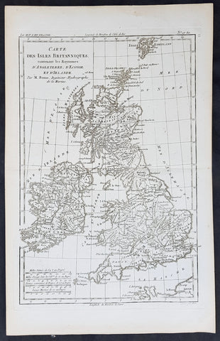
1780 Rigobert Bonne Original Antique Map of Great Britain and Ireland
- Title : Carte Des Isles Britanniques...M Bonne
- Size: 15in x 10in (380mm x 255mm)
- Ref #: 31667
- Date : 1780
- Condition: (A+) Fine Condition
Description:
This original copper-plate engraved map was published in 1780 edition of Atllas des toutes les parties connues du globe terrestre by Rigobert Bonne & Guillaume Raynal.
General Definitions:
Paper thickness and quality: - Heavy and stable
Paper color : - off white
Age of map color: -
Colors used: -
General color appearance: -
Paper size: - 15in x 10in (380mm x 255mm)
Plate size: - 13in x 9in (330mm x 230mm)
Margins: - Min 1in (25mm)
Imperfections:
Margins: - None
Plate area: - None
Verso: - None
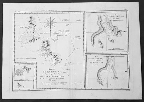
1780 Bonne Original Antique Map of Kerguelen, Desolation Island South Indian Ocean
- Title : Terre De Kerguelen, Appellee par M. Cook, Isle De La Desolation. Par M. Bonne; Plan Du Port Palliser dans la Terre De Kerguelen: Plan Du Havre De Noel dans la Terre De Kerguelen: Isles decouvertes par Mr. Marion Du Fresne en 1772, appellees par M.Cook en 1776, Isles Du Prince Edouard
- Size: 16in x 11in (405mm x 2805mm)
- Ref #: 40585
- Date : 1780
- Condition: (A) Very Good Condition
Description:
This fine original copper-plate engraved antique map of parts of the Kerguelen Islands, also known as the Desolation Islands, in the southern Indian Ocean, was published in 1780 edition of Atlas des toutes les parties connues du globe terrestre by Rigobert Bonne & Guillaume Raynal.
The map also includes three inset maps, the first two of Port Palliser & Noel Bay on Kerguelen Island, with the third inset map of the Prince Edward Islands - part of South Africa.
General Definitions:
Paper thickness and quality: - Heavy and stable
Paper color : - off white
Age of map color: -
Colors used: -
General color appearance: -
Paper size: - 16in x 11in (405mm x 2805mm)
Plate size: - 14in x 10in (355mm x 255mm)
Margins: - Min 1/2in (12mm)
Imperfections:
Margins: - None
Plate area: - Two small worm holes adjacent to bottom centerfold
Verso: - None
Background:
Kerguelen’s land was named for Yves de Kerguelen, a French navigator and explorer who sailed around the islands in 1772 along with Marion Du Fresne another French explorer who was in the vicinity in that same year. Capt. James Cook didn’t sight the islands until his 3rd voyage in 1776, having failed in his first attempts on earlier voyages. On Christmas Eve 1776, Cook’s ships the Resolution and the Discovery anchored in a Bay which he called Christmas Harbor, only staying long enough to replenish his water, and as the islands were so bleak and treeless, he called them Desolation Isles. Bonne’s chart was taken from original surveys by Kerguelen, Du Fresne and Capt. James Cook and was finely engraved by Gaspard Andre.
The Kerguelen Islands also known as the Desolation Islands, are a group of islands in the southern Indian Ocean constituting one of the two exposed parts of the mostly submerged Kerguelen Plateau. They are among the most isolated places on Earth, located 450 km (280 mi) northwest of the uninhabited Heard Island and McDonald Islands and more than 3,300 km (2,051 mi) from Madagascar, the nearest populated location (excluding the Alfred Faure scientific station in Ile de la Possession, about 1,340 km (830 mi) from there, and the non-permanent station located in Île Amsterdam, 1,440 km (890 mi) away). The islands, along with Adélie Land, the Crozet Islands, Amsterdam, and Saint Paul Islands, and France\'s Scattered Islands in the Indian Ocean are part of the French Southern and Antarctic Lands and are administered as a separate district.
Kerguelen Islands appear as the \"Ile de Nachtegal\" on Philippe Buache\'s map from 1754 before the island was officially discovered in 1772. The Buache map has the title Carte des Terres Australes comprises entre le Tropique du Capricorne et le Pôle Antarctique où se voyent les nouvelles découvertes faites en 1739 au Sud du Cap de Bonne Esperance (\'Map of the Southern Lands contained between the Tropic of Capricorn and the Antarctic Pole, where the new discoveries made in 1739 to the south of the Cape of Good Hope may be seen\'). It is possible this early name was after Abel Tasman\'s ship \"De Zeeuwsche Nachtegaal.\" On the Buache map, \"Ile de Nachtegal\" is located at 43°S, 72°E, about 6 degrees north and 2 degrees east of the accepted location of Grande Terre.
The islands were officially discovered by the French navigator Yves-Joseph de Kerguelen-Trémarec on 12 February 1772. The next day Charles de Boisguehenneuc landed and claimed the island for the French crown. Yves de Kerguelen organised a second expedition in 1773 and arrived at the \"baie de l\'Oiseau\" by December of the same year. On 6 January 1774 he commanded his lieutenant, Henri Pascal de Rochegude, to leave a message notifying any passers-by of the two passages and of the French claim to the islands. Thereafter, a number of expeditions briefly visited the islands, including that of Captain James Cook in December 1776 during his third voyage, who verified and confirmed the passage of de Kerguelen by discovering and annotating the message left by the French navigator.
Soon after their discovery, the archipelago was regularly visited by whalers and sealers (mostly British, American and Norwegian) who hunted the resident populations of whales and seals to the point of near extinction, including fur seals in the 18th century and elephant seals in the 19th century. Since the end of the whaling and sealing era, most of the islands\' species have been able to increase their population again.
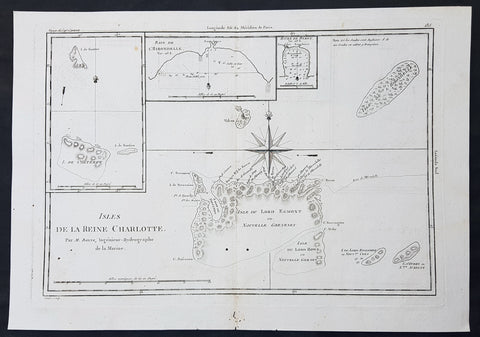
1780 Bonne Original Antique Map of Santa Cruz Isles, Solomon Islands Sth Pacific Lord Howe, Nendo
- Title : Isles De La Reine Charlotte
- Size: 16in x 11in (405mm x 2805mm)
- Ref #: 40580
- Date : 1780
- Condition: (A) Very Good Condition
Description:
This fine original copper-plate engraved antique map of Santa Cruz Island, of the Temotu Province in the Solomon Islands, Nendo Island & Lord Howe Island was published in 1780 edition of Atlas des toutes les parties connues du globe terrestre by Rigobert Bonne & Guillaume Raynal.
General Definitions:
Paper thickness and quality: - Heavy and stable
Paper color : - off white
Age of map color: -
Colors used: -
General color appearance: -
Paper size: - 16in x 11in (405mm x 2805mm)
Plate size: - 14in x 10in (355mm x 255mm)
Margins: - Min 1/2in (12mm)
Imperfections:
Margins: - Small worm holes in bottom margin
Plate area: - Two small worm holes adjacent to bottom centerfold
Verso: - None
Background:
Map of four island with compass rose. Santa Cruz Island, of Santa Cruz Island, of the Temotu Province in the Solomon Islands, based on Cook\'s discoveries, was named after Queen Charlotte, wife of King George III.
The Isle du Lord Edgemont (present day Nendo Island) and Isle du Lord Howe islands have been only partially engraved to show the explored portions.
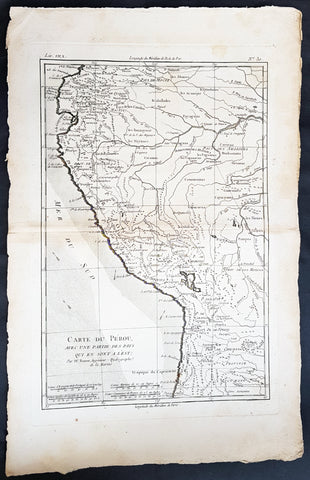
1780 Rigobert Bonne Antique Map of West South America Peru & The Amazon River
- Title : Carte Du Perou... Par M. Bonne
- Ref #: 40843
- Size: 17in x 11 1/2in (430mm x 290mm)
- Date : 1780
- Condition: (A+) Fine Condition
Description:
This fine original copper plate engraved antique map of Peru & the western Amazon River by Rigobert Bonne was published in the 1780 edition of Atlas des toutes les parties connues du globe terrestre by Guillaume Raynal.
General Definitions:
Paper thickness and quality: - Heavy and stable
Paper color : - off white
Age of map color: -
Colors used: -
General color appearance: -
Paper size: - 16in x 11in (410mm x 270mm)
Plate size: - 13in x 9in (330mm x 230mm)
Margins: - Min 1/2in (12mm)
Imperfections:
Margins: - None
Plate area: - None
Verso: - None
Background:
Peru officially the Republic of Peru is a country in western South America. It is bordered in the north by Ecuador and Colombia, in the east by Brazil, in the southeast by Bolivia, in the south by Chile, and in the west by the Pacific Ocean.
Atahualpa (also Atahuallpa), the last Sapa Inca became emperor when he defeated and executed his older half-brother Huáscar in a civil war sparked by the death of their father, Inca Huayna Capac. In December 1532, a party of conquistadors led by Francisco Pizarro defeated and captured the Inca Emperor Atahualpa in the Battle of Cajamarca. The Spanish conquest of the Inca Empire was one of the most important campaigns in the Spanish colonization of the Americas. After years of preliminary exploration and military conflicts, it was the first step in a long campaign that took decades of fighting but ended in Spanish victory and colonization of the region known as the Viceroyalty of Peru with its capital at Lima, which became known as The City of Kings. The conquest of the Inca Empire led to spin-off campaigns throughout the viceroyalty as well as expeditions towards the Amazon Basin as in the case of Spanish efforts to quell Amerindian resistance. The last Inca resistance was suppressed when the Spaniards annihilated the Neo-Inca State in Vilcabamba in 1572.
The indigenous population dramatically collapsed due to exploitation, socioeconomic change and epidemic diseases introduced by the Spanish. Viceroy Francisco de Toledo reorganized the country in the 1570s with gold and silver mining as its main economic activity and Amerindian forced labor as its primary workforce. With the discovery of the great silver and gold lodes at Potosí (present-day Bolivia) and Huancavelica, the viceroyalty flourished as an important provider of mineral resources. Peruvian bullion provided revenue for the Spanish Crown and fueled a complex trade network that extended as far as Europe and the Philippines. Because of lack of available work force, African slaves were added to the labor population. The expansion of a colonial administrative apparatus and bureaucracy paralleled the economic reorganization. With the conquest started the spread of Christianity in South America; most people were forcefully converted to Catholicism, taking only a generation to convert the population. They built churches in every city and replaced some of the Inca temples with churches, such as the Coricancha in the city of Cusco. The church employed the Inquisition, making use of torture to ensure that newly converted Catholics did not stray to other religions or beliefs. Peruvian Catholicism follows the syncretism found in many Latin American countries, in which religious native rituals have been integrated with Christian celebrations. In this endeavor, the church came to play an important role in the acculturation of the natives, drawing them into the cultural orbit of the Spanish settlers.
By the 18th century, declining silver production and economic diversification greatly diminished royal income. In response, the Crown enacted the Bourbon Reforms, a series of edicts that increased taxes and partitioned the Viceroyalty. The new laws provoked Túpac Amaru II\'s rebellion and other revolts, all of which were suppressed. As a result of these and other changes, the Spaniards and their creole successors came to monopolize control over the land, seizing many of the best lands abandoned by the massive native depopulation. However, the Spanish did not resist the Portuguese expansion of Brazil across the meridian. The Treaty of Tordesillas was rendered meaningless between 1580 and 1640 while Spain controlled Portugal. The need to ease communication and trade with Spain led to the split of the viceroyalty and the creation of new viceroyalties of New Granada and Rio de la Plata at the expense of the territories that formed the viceroyalty of Peru; this reduced the power, prominence and importance of Lima as the viceroyal capital and shifted the lucrative Andean trade to Buenos Aires and Bogotá, while the fall of the mining and textile production accelerated the progressive decay of the Viceroyalty of Peru.
Eventually, the viceroyalty would dissolve, as with much of the Spanish empire, when challenged by national independence movements at the beginning of the nineteenth century. These movements led to the formation of the majority of modern-day countries of South America in the territories that at one point or another had constituted the Viceroyalty of Peru. The conquest and colony brought a mix of cultures and ethnicities that did not exist before the Spanish conquered the Peruvian territory. Even though many of the Inca traditions were lost or diluted, new customs, traditions and knowledge were added, creating a rich mixed Peruvian culture. Two of the most important indigenous rebellions against the Spanish were that of Juan Santos Atahualpa in 1742, and Rebellion of Túpac Amaru II in 1780 around the highlands near Cuzco.
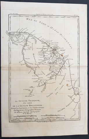
1780 Bonne Antique Map of French & Dutch Guyana, South America
- Title : La Guyane Francoise avec Partie De La Guyane Hollandoise... Par M. Bonne
- Ref #: 40849
- Size: 15in x 10in (385mm x 255mm)
- Date : 1780
- Condition: (A+) Fine Condition
Description:
This fine original antique map of French & Dutch Guyana, South America by Rigobert Bonne was published in the 1780 edition of Atlas des toutes les parties connues du globe terrestre by Guillaume Raynal. (Ref Tooley M&B)
General Description:
Paper thickness and quality: - Heavy and stable
Paper color: - White
Age of map color: -
Colors used: -
General color appearance: -
Paper size: - 15in x 10in (385mm x 255mm)
Plate size: - 13in x 9in (330mm x 230mm)
Margins: - Min 1in (25mm)
Imperfections:
Margins: - Light age toning
Plate area: - Light age toning
Verso: - Light age toning
Background:
In 1498 French Guiana was first visited by Europeans when Christopher Columbus sailed to the region on his third voyage and named it the \"Land of pariahs\".[citation needed] In 1608 the Grand Duchy of Tuscany did an expedition to the area in order to create an Italian colony for the commerce of Amazonian products to Renaissance Italy, but the sudden death of Ferdinando I de\' Medici, Grand Duke of Tuscany stopped it.
In 1624 France attempted to settle in the area, but was forced to abandon it in the face of hostility from the Portuguese, who viewed it as a violation of the Treaty of Tordesillas. However French settlers returned in 1630 and in 1643 managed to establish a settlement at Cayenne along with some small-scale plantations. This second attempt would again be abandoned following Amerindian attacks. In 1658 the Dutch West Indies Company seized French territory to establish the Dutch colony of Cayenne. The French returned once more in 1664, and founded a second settlement at Sinnamary (this was attacked by the Dutch in 1665).
In 1667 the English seized the area. Following the Treaty of Breda on 31 July 1667 the area was given back to France. The Dutch briefly occupied it for a period in 1676.
After the Treaty of Paris in 1763, which deprived France of almost all her possessions in the Americas other than Guiana and a few islands, Louis XV sent thousands of settlers to Guiana who were lured there with stories of plentiful gold and easy fortunes to be made. Instead they found a land filled with hostile natives and tropical diseases. One and a half years later only a few hundred survived. These fled to three small islands which could be seen off shore and named them the Iles de Salut (or \"Islands of Salvation\"). The largest was called Royal Island, another St. Joseph (after the patron saint of the expedition), and the smallest of the islands, surrounded by strong currents, Île du Diable (the infamous \"Devil\'s Island\"). When the survivors of this ill-fated expedition returned home, the terrible stories they told of the colony left a lasting impression in France.
In 1794, after the death of Robespierre, 193 of his followers were sent to French Guiana. In 1797 the republican general Pichegru and many deputies and journalists were also sent to the colony. When they arrived they found that only 54 of the 193 deportées sent out three years earlier were left; 11 had escaped, and the rest had died of tropical fevers and other diseases. Pichegru managed to escape to the United States and then returned to France where he was eventually executed for plotting against Napoleon.
Later on, slaves were brought out from Africa and plantations were established along the more disease-free rivers. Exports of sugar, hardwood, Cayenne pepper and other spices brought a certain prosperity to the colony for the first time. Cayenne, the capital, was surrounded by plantations, some of which had several thousand slaves.

1780 Rigobert Bonne Original Antique Map of Peru, South America
- Title : Perou et Pays Circonvoisins... Par M. Bonne
- Ref #: 40551
- Size: 17in x 11 1/2in (430mm x 290mm)
- Date : 1780
- Condition: (A+) Fine Condition
Description:
This fine original antique map of French & Dutch Guyana, South America by Rigobert Bonne was published in the 1780 edition of Atlas des toutes les parties connues du globe terrestre by Guillaume Raynal. (Ref Tooley M&B)
General Description:
Paper thickness and quality: - Heavy and stable
Paper color: - White
Age of map color: -
Colors used: -
General color appearance: -
Paper size: - 17in x 11 1/2in (430mm x 290mm)
Plate size: - 14 1/2in x 10 1/2in (370mm x 265mm)
Margins: - Min 1in (25mm)
Imperfections:
Margins: - None
Plate area: - None
Verso: - None
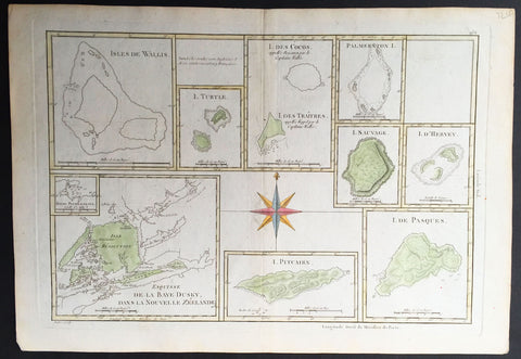
1780 Bonne Antique Map of South Pacific Islands Dusky Bay, Pitcairn, Easter Isle
- Title : Isle De Wallis; I. Turtle; I. Des Cocos; Palmerstin I.; I. Sauvage; I. D' Hervey; Esuisse De La Baye Dusky Dans La Nouvelle Zeelande; I. Pitcairn; I. De Pasques
- Ref #: 32193
- Size: 16in x 11in (405mm x 2805mm)
- Date : 1780
- Condition: (A+) Fine Condition
Description:
This finely engraved hand coloured original antique map showing 9 various Islands of the South Pacific all related to the discoveries of Capt. James Cook - including Dusky Sound in New Zealand, Pitcairn Island; Cocos Island; Easter Island and more - was published in the 1780 edition of Atllas des toutes les parties connues du globe terrestre by Rigobert Bonne & Guillaume Raynal. (Ref Tooley M&B)
General Description:
Paper thickness and quality: - Heavy and stable
Paper color: - White
Age of map color: - Early
Colors used: - Green, yellow, red, blue
General color appearance: - Authentic
Paper size: - 16in x 11in (405mm x 2805mm)
Plate size: - 14 1/2in x 10in (370mm x 255mm)
Margins: - Min ½in (12mm)
Imperfections:
Margins: - None
Plate area: - None
Verso: - None
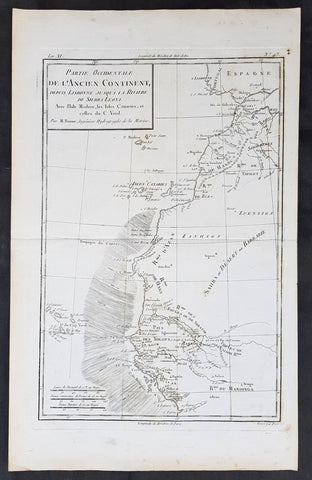
1780 Rigobert Bonne Original Antique Map NW Africa Morocco to Senegal Canary Is.
- Title : Partie Occidentale De L Ancien Continent ...M Bonne
- Size: 15in x 10in (390mm x 255mm)
- Ref #: 31693
- Date : 1780
- Condition: (A+) Fine Condition
Description:
This original copper-plate engraved map was published in 1780 edition of Atllas des toutes les parties connues du globe terrestre by Rigobert Bonne & Guillaume Raynal.
General Definitions:
Paper thickness and quality: - Heavy and stable
Paper color : - off white
Age of map color: -
Colors used: -
General color appearance: -
Paper size: - 15in x 10in (390mm x 255mm)
Plate size: - 13in x 9in (330mm x 235mm)
Margins: - Min 1/4in (8mm)
Imperfections:
Margins: - None
Plate area: - None
Verso: - None
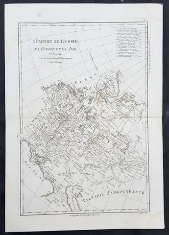
1780 Rigobert Bonne Original Antique Map of Western, European Russia, Poland
- Title : L Empire de Russie en Europe et an Asie...M Bonne
- Size: 15in x 10in (380mm x 255mm)
- Ref #: 40527
- Date : 1780
- Condition: (A+) Fine Condition
Description:
This original copper-plate engraved map was published in 1780 edition of Atllas des toutes les parties connues du globe terrestre by Rigobert Bonne & Guillaume Raynal.
General Definitions:
Paper thickness and quality: - Heavy and stable
Paper color : - off white
Age of map color: -
Colors used: -
General color appearance: -
Paper size: - 15in x 10in (380mm x 255mm)
Plate size: - 13in x 9in (330mm x 230mm)
Margins: - Min 1in (25mm)
Imperfections:
Margins: - None
Plate area: - None
Verso: - None
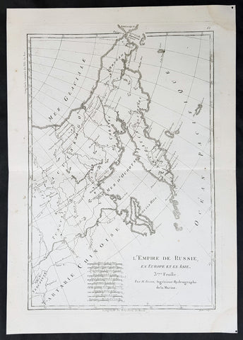
1780 Rigobert Bonne Original Antique Map of Eastern Russia, China
- Title : L Empire de Russie en Europe et an Asie...M Bonne
- Size: 15in x 10in (380mm x 255mm)
- Ref #: 40528
- Date : 1780
- Condition: (A+) Fine Condition
Description:
This original copper-plate engraved map was published in 1780 edition of Atllas des toutes les parties connues du globe terrestre by Rigobert Bonne & Guillaume Raynal.
General Definitions:
Paper thickness and quality: - Heavy and stable
Paper color : - off white
Age of map color: -
Colors used: -
General color appearance: -
Paper size: - 15in x 10in (380mm x 255mm)
Plate size: - 13in x 9in (330mm x 230mm)
Margins: - Min 1in (25mm)
Imperfections:
Margins: - None
Plate area: - None
Verso: - None
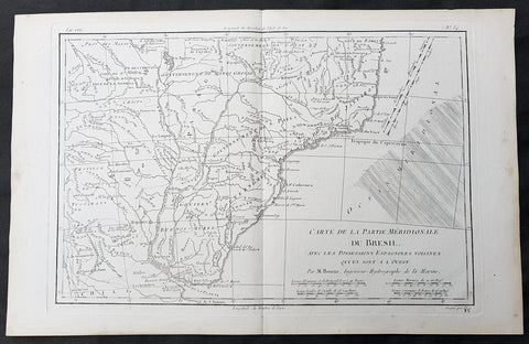
1780 Rigobert Bonne Original Antique Map of Brazil, South America
- Title : Carte de la Partie Meridionale Du Bresil....M Bonne
- Size: 15in x 10in (380mm x 255mm)
- Ref #: 31684
- Date : 1780
- Condition: (A+) Fine Condition
Description:
This original copper-plate engraved map was published in 1780 edition of Atllas des toutes les parties connues du globe terrestre by Rigobert Bonne & Guillaume Raynal.
General Definitions:
Paper thickness and quality: - Heavy and stable
Paper color : - off white
Age of map color: -
Colors used: -
General color appearance: -
Paper size: - 15in x 10in (380mm x 255mm)
Plate size: - 13in x 9in (330mm x 230mm)
Margins: - Min 1in (25mm)
Imperfections:
Margins: - None
Plate area: - None
Verso: - None