
Emmanuel Bowen (1714 - 1767) Thomas Bowen (died 1790)
Profile :
Emmanuel Bowen and his son Thomas Bowen were a prominent father-son duo of cartographers in 18th century England.
Emmanuel Bowen was born in Wales in 1714 and moved to London in his early twenties. He became an apprentice under the engraver Charles Price and later established his own business as a map engraver and publisher. Bowen quickly gained a reputation for his skill in engraving and his expertise in cartography.
In 1747, Emmanuel Bowen was appointed as Mapmaker to George II, a position that gave him access to the latest geographic information and helped establish his reputation as a leading cartographer. Bowen produced a number of important maps and atlases during his career, including a series of county maps of England and Wales and a world atlas titled "A Complete Atlas, or Distinct View of the Known World," which was published in 1752.
After Emmanuel Bowen's death in 1767, his son Thomas took over the family business. Thomas was also a skilled cartographer and continued to publish maps and atlases under the name of his father's business. Some of the notable works produced by Thomas Bowen include a map of the British colonies in North America and a map of the West Indies.
Emmanuel and Thomas Bowen are known for their accurate and detailed maps, which were highly sought after by collectors and scholars of the time. Their maps are characterized by their attention to detail, clarity, and elegance of design. The Bowen family's maps were used extensively in schools and libraries, and their legacy as prominent cartographers has been recognized for centuries.
Emmanuel & Thomas Bowen (1)
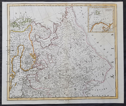
1765 T. Bowen & M Postlethweyt Antique Map of European Russia, Baltics, Lapland
- Title : Europe Plate II
- Date : 1765
- Size: 17 1/2in x 14 1/2in (445mm x 370mm)
- Condition: (A+) Fine Condition
- Ref: 01-1584
Description:
This wonderful large detailed original copper plate engraved antique map of European Russia, parts of Lapland, Sweden, Latvia & Lithuania by Thomas Bowen was published in the 1765 edition of Malachy Postlethweyts monumental 2 Volume tomes on Universal Dictionary of Trade & Commerce concentrating on various states of trade, including slavery, between England and America published between 1751 & 1774.
General Definitions:
Paper thickness and quality: - Heavy and stable
Paper color : - off white
Age of map color: - Original
Colors used: - Blue, orange, green
General color appearance: - Authentic
Paper size: - 17 1/2in x 14 1/2in (445mm x 370mm)
Plate size: - 17in x 14in (430mm x 355mm)
Margins: - Min 1/2in (8mm)
Imperfections:
Margins: - None
Plate area: - Light creasing
Verso: - None
Background:
It is scarcely necessary to look at a map of Russia - with which we must include Siberia - to visualize the daunting task facing Russian map makers. Indeed, considering the vastness of their territory and the lack of skilled cartographers, it is surprising that relatively good maps were available for engraving and printing in most of the well known sixteenth and seventeenth century atlases. Generally, maps of that time were based on material brought back from Moscow by visitors from the West.
Postlethweyt, Malachy 1707 – 1767
Malachy Postlethweyts Dictionary of Trade & Commerce:
A monumental dictionary of trade and commerce. It is based in part on the Dictionnaire universel de Commerce (Paris: 1723-30) of Jacques Savary de Bruslon, under whose name it is often catalogued, but has been adapted by Postlethwayt for a British audience, with substantial enlargements and improvements, and entirely new material relating to England and her colonies. Postlethwayt devoted twenty years to the preparation of the dictionary, which was first published in 1751-55 & includes a description of British affairs in North America since the peace of 1763.
As with his other works, the dictionary demonstrates Postlethway’s deep commitment to the expansion and strengthening of English trade. Included are entries for geographical locations (Africa, Antilles, Canada, Japan, Louisiana, &c.), products (brandy, cardamom, codfish, diamonds, sugar, &c.), trading companies (Dutch East India Company, English African Company, &c.), treaties of commerce, and a vast range of other information of value to merchants (bankruptcy, currency, bills of exchange, brokerage, exportation, landed interest, privateering, &c.). The Dictionary is also important for containing almost the whole substance of Richard Cantillon’s Essay on Commerce, its first appearance in print.