
Emmanuel Bowen (1714 - 1767) Thomas Bowen (died 1790)
Profile :
Emmanuel Bowen and his son Thomas Bowen were a prominent father-son duo of cartographers in 18th century England.
Emmanuel Bowen was born in Wales in 1714 and moved to London in his early twenties. He became an apprentice under the engraver Charles Price and later established his own business as a map engraver and publisher. Bowen quickly gained a reputation for his skill in engraving and his expertise in cartography.
In 1747, Emmanuel Bowen was appointed as Mapmaker to George II, a position that gave him access to the latest geographic information and helped establish his reputation as a leading cartographer. Bowen produced a number of important maps and atlases during his career, including a series of county maps of England and Wales and a world atlas titled "A Complete Atlas, or Distinct View of the Known World," which was published in 1752.
After Emmanuel Bowen's death in 1767, his son Thomas took over the family business. Thomas was also a skilled cartographer and continued to publish maps and atlases under the name of his father's business. Some of the notable works produced by Thomas Bowen include a map of the British colonies in North America and a map of the West Indies.
Emmanuel and Thomas Bowen are known for their accurate and detailed maps, which were highly sought after by collectors and scholars of the time. Their maps are characterized by their attention to detail, clarity, and elegance of design. The Bowen family's maps were used extensively in schools and libraries, and their legacy as prominent cartographers has been recognized for centuries.
Emmanuel & Thomas Bowen (10)
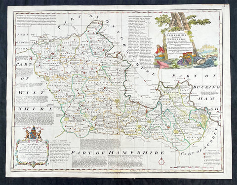
1756 Emmanuel Bowen Large Antique Map of The English County of Berkshire
- Title : An Accurate Map of Berkshire Divided into Hundreds...by Emmanual Bowen....Printed for Carrington Bowles....1756
- Ref #: 27014
- Size: 29in x 22 1/2in (750mm x 570mm)
- Date : 1756
- Condition: (A+) Fine Condition
Description:
This large original beautifully hand coloured antique map of the English County of Berkshire by Emmanuel Bowen was engraved in 1756 - dated at the foot of the map - and was published by Carrington Bowles in The Large English Atlas. (Ref: Tooley; M&B)
General Definitions:
Paper thickness and quality: - Heavy and stable
Paper color : - off white
Age of map color: - Original & later
Colors used: - Yellow, green, blue, pink
General color appearance: - Authentic
Paper size: - 29in x 22 1/2in (750mm x 570mm)
Plate size: - 27 1/2in x 21 1/2in (700mm x 545mm)
Margins: - Min 1in (25mm)
Imperfections:
Margins: - None
Plate area: - None
Verso: - None
Background:
The Large English Atlas was, as its name suggests, a large folio series of county maps conceived in about 1749 but, because of financial problems, not completed until 1760. Hodson describes the atlas as by far the most important eighteenth-century English atlas to be published before the appearance of John Carys New And Correct English Atlas in 1787. Earlier county atlases were predominantly derivative, using old survey work, many in fact, traceable back to Saxtons work of the sixteenth century. The Large English Atlas maps were drawn from the most up-to-date surveys, and so mark an important stage in the development of the county atlas (Hodson). Through its commercial success, this atlas encouraged a new generation of county atlases, of both large and small scales, but of greater precision than before. The maps, drawn either by Emanuel Bowen or Thomas Kitchin, are finely produced. A particular feature is the vast amount of additional detail engraved in the blank areas around the map, lists of the landed gentry, descriptions of the towns, produce and other notable features of each county, and in some cases, fine insets of the county town. All have elaborate title cartouches, illustrating the produce of the county, rural scenes and so on, many signed by Antony Walker Jr. Besides the separately published multi-sheet maps of various counties these are the most detailed and most interesting county maps of the eighteenth century.
Please note all items auctioned are genuine, we do not sell reproductions. A Certificate of Authenticity (COA) can be issued on request.
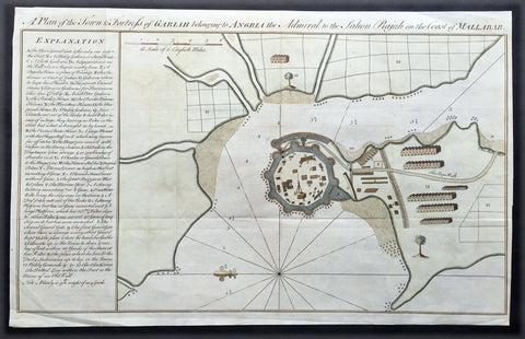
1760 Bowen Antique Map, Plan Fort & Town of Vijaydurg, Maharashtra State, India
- Title : A plan of the town and fortress of Gariah belonging to Angriah the admiral to the Sahou Rajah
- Size: 18 1/4in x 12in (465mm x 305mm)
- Condition: (A+) Fine Condition
- Date : 1760
- Ref #: 21950
Description:
This beautifully hand coloured original copper-plate engraved antique map, a plan of the fort and town of Gheriah, Girye or Gheriya, today called Vijaydurg in Maharashtra state in NW India (485 kms from Mumbai) was published by Emmanual Bowen in 1760.
The map contains many numbered & lettered references to particular areas of interest within the fort, town and surrounds.
General Definitions:
Paper thickness and quality: - Heavy and stable
Paper color : - off white
Age of map color: -
Colors used: -
General color appearance: -
Paper size: - 18 1/4in x 12in (465mm x 305mm)
Plate size: - 18 1/4in x 12in (465mm x 305mm)
Margins: - Min 1/2in (12mm)
Imperfections:
Margins: - Light creasing
Plate area: - Folds as issued
Verso: - Folds as issued
Background:
Vijaydurg is said to be the oldest fort in Sindhudurg coast. In the Pre-Independence era it was also known as Eastern Gibraltar. This is because the fort was almost unconquerable. Under the leadership of Kanhoji Angre, it withstood many naval attacks by the British and the Dutch. Kanhoji Angre died on 4 July 1729 and the Angres control of the fort ended in 1756 after the Peshwa-British Alliance defeated the Angres clan. In 1818 Vijaydurg was completely in the hand of the British Empire.
Kanhoji Angre 1669 – 1729 was a chief of the Maratha Navy in 18th century India. In historical records, he is also known as Conajee Angria or Sarkhel Angré (Sarkhel is a title equal to Admiral of a fleet).
Kanhoji fought against the British, Dutch and Portuguese naval interests on the coasts of India during the 18th century. As a result, his European enemies labeled him a pirate. Despite the attempts of the British and Portuguese to subdue Angre, he remained undefeated until his death.
1760 Bowen Antique Map, Plan Fort & Town of Vijaydurg, Maharashtra State, India
- Title : A plan of the town and fortress of Gariah belonging to Angriah the admiral to the Sahou Rajah
- Size: 18 1/4in x 12in (465mm x 305mm)
- Condition: (A+) Fine Condition
- Date : 1760
- Ref #: 40986-2
Description:
This original copper-plate engraved antique map, a plan of the fort and town of Gheriah, Girye or Gheriya, today called Vijaydurg in Maharashtra state in NW India (485 kms from Mumbai) was published by Emmanual Bowen in 1760.
The map contains many numbered & lettered references to particular areas of interest within the fort, town and surrounds.
General Definitions:
Paper thickness and quality: - Heavy and stable
Paper color : - off white
Age of map color: -
Colors used: -
General color appearance: -
Paper size: - 18 1/4in x 12in (465mm x 305mm)
Plate size: - 18 1/4in x 12in (465mm x 305mm)
Margins: - Min 1/2in (12mm)
Imperfections:
Margins: - Light creasing
Plate area: - Folds as issued
Verso: - Folds as issued
Background:
Vijaydurg is said to be the oldest fort in Sindhudurg coast. In the Pre-Independence era it was also known as Eastern Gibraltar. This is because the fort was almost unconquerable. Under the leadership of Kanhoji Angre, it withstood many naval attacks by the British and the Dutch. Kanhoji Angre died on 4 July 1729 and the Angres control of the fort ended in 1756 after the Peshwa-British Alliance defeated the Angres clan. In 1818 Vijaydurg was completely in the hand of the British Empire.
Kanhoji Angre 1669 – 1729 was a chief of the Maratha Navy in 18th century India. In historical records, he is also known as Conajee Angria or Sarkhel Angré (Sarkhel is a title equal to Admiral of a fleet).
Kanhoji fought against the British, Dutch and Portuguese naval interests on the coasts of India during the 18th century. As a result, his European enemies labeled him a pirate. Despite the attempts of the British and Portuguese to subdue Angre, he remained undefeated until his death.
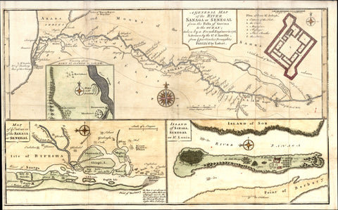
1760 Bowen, D Anville Map Entrance of River Sanaga, St Louis Senegal West Africa
- Title : A General Map of The River Sanaga or Senegal; Map of ye Entrance of the Sanga or Senegal; Island of Sanaga Senegal or St Louis.
- Date : 1760
- Condition: (A) Very Good Condition
- Ref: 31879
- Size: 16in x 10in (405mm x 255mm)
Description:
This large beautifully hand coloured original antique map of three view of the River, River Mouth & Island of St Louis of the Sangha River in Senegal West Africa by Thomas Bowen - after D anville - was published in 1760. (Ref: Tooley; M&B)
General Description:
Paper thickness and quality: - Heavy and stable
Paper color: - white
Age of map color: - Early
Colors used: - Yellow, green, pink, blue
General color appearance: - Authentic
Paper size: - 16in x 10in (405mm x 255mm)
Plate size: - 16in x 10in (405mm x 255mm)
Margins: - min. 1/4in (6mm)
Imperfections:
Margins: - Folds as issued
Plate area: - Folds as issued, light creasing along folds
Verso: - Folds as issued, light creasing along folds
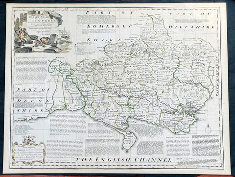
1760 Emanuel Bowen Large English County Map of Dorset Shire
- Title : An Accurate Map of Dorsetshire, Divided into its Hundreds. Drawn from the best Authorities, assisted by the most approved Maps and Charts with various Improvements illustrated with Historical Extracts relative to its Natural Produce, Manufactures, Trade, present state of it’s principal Towns and Sea Ports, by Eman Bowen geographer to His Majesty.
- Date : 1760
- Size: 29in x 22 1/2in (750mm x 570mm)
- Condition: (A+) Fine Condition
- Ref: 35614
Description:
This large original beautifully hand coloured antique map of the English County of Dorset Shire by Emmanuel Bowen was published by Carrington Bowles in the 1760 edition of The Large English Atlas. (Ref: Tooley; M&B)
General Definitions:
Paper thickness and quality: - Heavy and stable
Paper color : - off white
Age of map color: - Original
Colors used: - Pink, blue, green, yellow
General color appearance: - Authentic
Paper size: - 29in x 22 1/2in (750mm x 570mm)
Plate size: - 27 1/2in x 21 1/2in (700mm x 545mm)
Margins: - Min 1/2in (12mm)
Imperfections:
Margins: - Light age toning in margins
Plate area: - None
Verso: - None
Background:
The Large English Atlas was, as its name suggests, a large folio series of county maps conceived in about 1749 but, because of financial problems, not completed until 1760. Hodson describes the atlas as by far the most important eighteenth-century English atlas to be published before the appearance of John Carys New And Correct English Atlas in 1787. Earlier county atlases were predominantly derivative, using old survey work, many in fact, traceable back to Saxtons work of the sixteenth century. The Large English Atlas maps were drawn from the most up-to-date surveys, and so mark an important stage in the development of the county atlas (Hodson). Through its commercial success, this atlas encouraged a new generation of county atlases, of both large and small scales, but of greater precision than before. The maps, drawn either by Emanuel Bowen or Thomas Kitchin, are finely produced. A particular feature is the vast amount of additional detail engraved in the blank areas around the map, lists of the landed gentry, descriptions of the towns, produce and other notable features of each county, and in some cases, fine insets of the county town. All have elaborate title cartouches, illustrating the produce of the county, rural scenes and so on, many signed by Antony Walker Jr. Besides the separately published multi-sheet maps of various counties these are the most detailed and most interesting county maps of the eighteenth century.

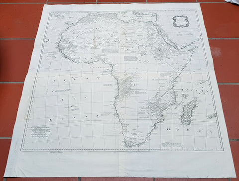
1765 Emmanuel Bowen Very Large Antique Map of Africa
- Title : Africa Performed by the Sr D Anville under the Patronage of the Duke of Orleansrevised and improved by Mr Bolton...E Bowen
- Date : 1765
- Size: 47in x 41in (1.20m x 1.04m)
- Ref #: 40910-1
- Condition: (A+) Fine Condition
Description:
This very large 4 sheet original copper plate engraved antique map of Africa by Solomon Bolton after the French cartographer Jean Baptiste Bourguignon D Anville, was engraved by Emmanuel Bowen and published in the 1765 edition of Malachy Postlethweyts monumental 2 Volume tomes on The Universal Dictionary of Trade & Commerce concentrating on various states of trade, including slavery, between England and America published between 1751 & 1774.
Malachy Postlethweyt 1707 – 1767
Malachy Postlethweyts Dictionary of Trade & Commerce:
A monumental dictionary of trade and commerce. It is based in part on the Dictionnaire universel de Commerce (Paris: 1723-30) of Jacques Savary de Bruslon, under whose name it is often catalogued, but has been adapted by Postlethwayt for a British audience, with substantial enlargements and improvements, and entirely new material relating to England and her colonies. Postlethwayt devoted twenty years to the preparation of the dictionary, which was first published in 1751-55 & includes a description of British affairs in North America since the peace of 1763.
As with his other works, the dictionary demonstrates Postlethway’s deep commitment to the expansion and strengthening of English trade. Included are entries for geographical locations (Africa, Antilles, Canada, Japan, Louisiana, &c.), products (brandy, cardamom, codfish, diamonds, sugar, &c.), trading companies (Dutch East India Company, English African Company, &c.), treaties of commerce, and a vast range of other information of value to merchants (bankruptcy, currency, bills of exchange, brokerage, exportation, landed interest, privateering, &c.). The Dictionary is also important for containing almost the whole substance of Richard Cantillons Essay on Commerce, its first appearance in print.
General Definitions:
Paper thickness and quality: - Heavy and stable
Paper color : - off white
Age of map color: -
Colors used: -
General color appearance: -
Paper size: - 47in x 41in (1.20m x 1.04m)
Plate size: - 40in x 39in (1.10m x 990mm)
Margins: - Min 1in (25mm)
Imperfections:
Margins: - None
Plate area: - Light age toning left fold
Verso: - None
Background:
This is one of the largest and most influential maps, of Africa, to appear in the mid-18th century. Engraved by Emmanuel Bowen after J.B. D Anville, the map covers the entire continent of Africa from the Mediterranean to the Cape of Good Hope and from the Cape Verde Islands to Madagascar. D Anville was a careful cartographer known for his scientific approach to map-making, and nowhere is this more evident than in this, one of his greatest and most innovative maps of Africa. Following the trajectory set by Guillaume de L Isle half a century earlier, D Anville takes a number of significant steps forward in addressing the confusions inherent in mapping this vast though mostly, in the mid-17th century, unexplored continent. These include unreliable cartographic suppositions regarding the African interior dating practically to antiquity. Many of these, including such speculative ideas as the Mountains of Kong, have been diminished if not removed entirely from this map, leaving vast unexplored areas throughout.
What was known of Africa, however, D Anville incorporates here in an impressive compilation of the most up to date reports from colonial, missionary, and exploratory entradas into the interior of the continent. Thus well mapped parts of the continent are limited to the Mediterranean Coast, Morocco, the Senegambia, the Congo, South Africa, the Kingdom of Monomatapa, Abyssinia, and egypt. Morocco, egypt, and the southern Mediterranean Coast (Barbary) were well known to europeans since antiquity and D Anvilles accurate mapping of these regions reflects continual contact. Further south the colonial enclaves along the Niger River (Senegal and Gambia), the Congo River, and South Africa reflect considerable detail associated with European penetration by trader and missionaries. The land of Monomopota around the Zambezi River was explored early in the 16th century by the Portuguese in hopes that the legendary gold mines supposedly found there would counterbalance the wealth flowing into Spain from the New Word. Unfortunately these mines, often associated with the Biblical kingdom of Ophir, were mostly tapped out by the 15th century. Abyssinia (modern day ethiopia) was mapped in detail by early Italian missionaries and of considerable interest to Europeans first, because it was (and is) predominantly Christian; second, because it was a powerful well-organized and unified kingdom; and third because the sources of the Blue Nile were to be found here.
The remainder of the continent remained largely speculative though D Anville rarely lets his imagination get the upper hand. He does however follow the well-established Ptolemaic model laid down in the Geographica regarding the sources of the White Nile – here seen as two lakes at the base of the semi-apocryphal Mountains of the Moon. However, he also presents a curious network of interconnected rivers extending westward from the confused course of the White Nile following the popular 18th century speculation that the Nile may be connected to the Niger. To his credit Anville does not advocate this and offers no true commerce between the two river systems.
Lake Malawi, here identified as Maravi, appears in a long thin embryonic state that, though it had not yet been \\\'discovered,\\\' is remarkably accurate to form. Lake Malawi was not officially discovered until Portuguese trader Candido Jose da Costa Cardoso stumbled upon it in 1849 – one hundred years following Anvilles presentation of the lake here. Anvilles inclusion of Lake Malawi is most likely a prescient interpretation of indigenous reports brought to Europe by 17th century Portuguese traders. Its form would be followed by subsequent cartographers well into the mid-19th century when the explorations of John Hanning Speke, David Livingstone, Richard Francis Burton and others would at last yield a detailed study of Africas interior.
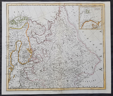
1765 T. Bowen & M Postlethweyt Antique Map of European Russia, Baltics, Lapland
- Title : Europe Plate II
- Date : 1765
- Size: 17 1/2in x 14 1/2in (445mm x 370mm)
- Condition: (A+) Fine Condition
- Ref: 01-1584
Description:
This wonderful large detailed original copper plate engraved antique map of European Russia, parts of Lapland, Sweden, Latvia & Lithuania by Thomas Bowen was published in the 1765 edition of Malachy Postlethweyts monumental 2 Volume tomes on Universal Dictionary of Trade & Commerce concentrating on various states of trade, including slavery, between England and America published between 1751 & 1774.
General Definitions:
Paper thickness and quality: - Heavy and stable
Paper color : - off white
Age of map color: - Original
Colors used: - Blue, orange, green
General color appearance: - Authentic
Paper size: - 17 1/2in x 14 1/2in (445mm x 370mm)
Plate size: - 17in x 14in (430mm x 355mm)
Margins: - Min 1/2in (8mm)
Imperfections:
Margins: - None
Plate area: - Light creasing
Verso: - None
Background:
It is scarcely necessary to look at a map of Russia - with which we must include Siberia - to visualize the daunting task facing Russian map makers. Indeed, considering the vastness of their territory and the lack of skilled cartographers, it is surprising that relatively good maps were available for engraving and printing in most of the well known sixteenth and seventeenth century atlases. Generally, maps of that time were based on material brought back from Moscow by visitors from the West.
Postlethweyt, Malachy 1707 – 1767
Malachy Postlethweyts Dictionary of Trade & Commerce:
A monumental dictionary of trade and commerce. It is based in part on the Dictionnaire universel de Commerce (Paris: 1723-30) of Jacques Savary de Bruslon, under whose name it is often catalogued, but has been adapted by Postlethwayt for a British audience, with substantial enlargements and improvements, and entirely new material relating to England and her colonies. Postlethwayt devoted twenty years to the preparation of the dictionary, which was first published in 1751-55 & includes a description of British affairs in North America since the peace of 1763.
As with his other works, the dictionary demonstrates Postlethway’s deep commitment to the expansion and strengthening of English trade. Included are entries for geographical locations (Africa, Antilles, Canada, Japan, Louisiana, &c.), products (brandy, cardamom, codfish, diamonds, sugar, &c.), trading companies (Dutch East India Company, English African Company, &c.), treaties of commerce, and a vast range of other information of value to merchants (bankruptcy, currency, bills of exchange, brokerage, exportation, landed interest, privateering, &c.). The Dictionary is also important for containing almost the whole substance of Richard Cantillon’s Essay on Commerce, its first appearance in print.
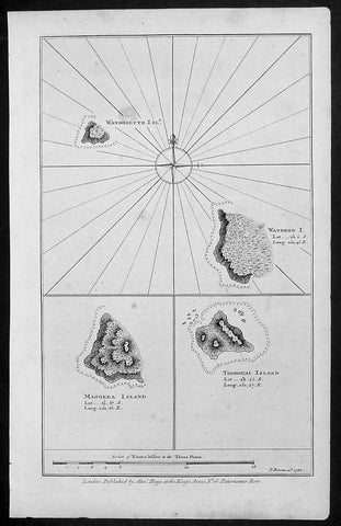
1786 Bowen Antique Map 3 x Cook Islands & 1 x Society Island - Cooks Voyage 1777
- Title : Wanooaette Isl; Wateeoo I; Mangeea Island Toobouai Island
- Size: 13 1/2in x 9 1/2in (345mm x 240mm)
- Ref #: 21697
- Date : 1786
- Condition: (A+) Fine Condition
Description:
This fine original copper-plate engraved antique map of three of the Cook Islands, Takutea (Wanooaette) Atiu (Wateeoo) and Mangaia (Mangeea) and a 4th map of the Island of Tubuai (Toobouai) in French Polynesia near Tahiti, visited by Captain Cook in HMS Resolution & Discovery in September 1777, during his 3rd & last Voyage of Discovery, was published in George Andersons A New, Authentic, and Complete Account of Voyages Round the World, Undertaken and Performed by Royal Authority. Containing a New, Authentic, Entertaining, Instructive, Full and Complete History of Captain Cooks First, Second, Third and Last Voyages.. ... published by Alexander Hogg, London 1786.
These maps of three Cook Islands :
1.Wanooaette, (Takutea)
2. Wateeoo (Atiu)
3. Mangeea ( Mangaia)
4. inset map of Toobouai (Tubuai) in the Society Islands in French Polynesia
All maps were charted by James Cook in 1777 while sailing for the Society Islands (French Polynesia) with livestock he carried aboard the Discovery and the Resolution. As he sailed toward Tahiti he discovered Toobouai (Tubuai) Island on 13 August 1777 where they stayed for 6 weeks. Relief shown by hachures and soundings.
General Definitions:
Paper thickness and quality: - Heavy and stable
Paper color : - off white
Age of map color: -
Colors used: -
General color appearance: -
Paper size: - 13 1/2in x 9 1/2in (345mm x 240mm)
Plate size: - 13 1/2in x 9 1/2in (345mm x 240mm)
Margins: - Min 1/2in (12mm)
Imperfections:
Margins: - None
Plate area: - None
Verso: - None
George William Anderson
A Collection of voyages round the world : performed by royal authority : containing a complete historical account of Captain Cooks first, second, third and last voyages, undertaken for making new discoveries, &c. ... : to which are added genuine narratives of other voyages of discovery round the world, &c. viz. those of Lord Byron, Capt. Wallis, Capt. Carteret, Lord Mulgrave, Lord Anson, Mr. Parkinson, Capt. Lutwidge, Mess. Ives, Middleton, Smith, &c published by Alex. Hogg, 1786.
Spanish ships visited the islands in the 16th century; the first written record of contact with the islands came in 1595 with the sighting of Pukapuka by Spanish sailor Álvaro de Mendaña de Neira, who called it San Bernardo (Saint Bernard). Pedro Fernandes de Queirós, a Portuguese captain working for the Spanish crown, made the first recorded European landing in the islands when he set foot on Rakahanga in 1606, calling it Gente Hermosa.
British navigator Captain James Cook arrived in 1773 and 1777 and named the island of Manuae Hervey Island. Later, the name Hervey Islands came to be applied to the entire southern group; the name Cook Islands, in honour of Cook, first appeared on a Russian naval chart published in the 1820s
Takutea, in the Cook Islands, is a small uninhabited island 21 kilometres northwest of Atiu in the southern Cook Islands.
Takutea is the only island in the Cook Islands that never had a permanent population. When Captain James Cook sighted the island on 4 April 1777, and some crew members went ashore, they found some huts, but no evidence of a permanent settlement.
Atiu, also known as Enuamanu (meaning land of the birds), is an island 187 km northeast of Rarotonga, in the Southern Islands group of the Cook Islands Archipelago.
The first recorded European to arrive at Atiu was Captain Cook. He sighted the island on March 31, 1777 and made tentative contact with some of the people over the next few days.
Mangaia (traditionally known as A ua u Enua, which means terraced) is the most southerly of the Cook Islands and the second largest, after Rarotonga.
The first recorded European to arrive at Mangaia was Captain James Cook on 29 March 1777.
Tubuai part of the Society Islands is located 640 km south of Tahiti. Tubuai was first viewed by Europeans when it was mapped by Captain James Cook in 1777, although his party did not disembark. Cook discovered the islands name, Toobouai, from the natives who surrounded his ship in their canoes (a Tahitian named Omai, who was part of Cooks group, translated)
The next Europeans to arrive were the mutineers of the HMS Bounty in 1789. Mutineer Fletcher Christian, in looking for an island on which to permanently hide, had scoured Blighs maps and nautical charts and decided on Tubuai.
Upon arrival at Tubuai, a conflict arose while the mutineers were still on their ship and several islanders were killed in their canoes. The site of this event in the lagoon on the north side of the island is called Baie Sanglant (Bloody Bay)
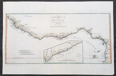
1788 Thomas Bowen Antique Map The Gulf of Guinea, West Africa - Liberia to Gabon
- Title : D Anvilles Map of the Coast of Guinea between Sierra Leone and the crossing of the Line Engraved for J Harrison, Feb 11 1788....T Bowen Sculp.
- Date : 1788
- Size: 19in x 12 1/2in (480mm x 320mm)
- Condition: (A+) Fine Condition
- Ref: 31418
Description:
This magnificent original copper-plate engraved antique map of he Gulf Of Guinea, West Africa from Liberia to Gabon, with an inset map of the Gold Coast, after J B D Anville, was engraved by Thomas Bowen in 1788 - dated in the title - and was published for John Harrisons Ancient & Modern Atlas
General Definitions:
Paper thickness and quality: - Heavy and stable
Paper color : - off white
Age of map color: - Original
Colors used: - Blue, orange, green
General color appearance: - Authentic
Paper size: - 19in x 12 1/2in (480mm x 320mm)
Plate size: - 18 1/2in x 9 1/2in (470mm x 240mm)
Margins: - Min 1/2in (8mm)
Imperfections:
Margins: - None
Plate area: - None
Verso: - None
Background:
Being part of the Mediterranean world, the northern coasts of the African continent as far as the Straits of Gibraltar and even round to the area of the Fortunate Isles (the Canaries) were reasonably well known and quite accurately mapped from ancient times. In particular, Egypt and the Nile Valley were well defined and the Nile itself was, of course, one of the rivers separating the continents in medieval T-O maps. Through Arab traders the shape of the east coast, down the Red Sea as far as the equator, was also known but detail shown in the interior faded into deserts with occasional mountain ranges and mythical rivers. The southern part of the continent, in the Ptolemaic tradition, was assumed to curve to the east to form a land-locked Indian Ocean. The voyages of the Portuguese, organized by Henry the Navigator in the fifteenth century, completely changed the picture and by the end of the century Vasco da Gama had rounded the Cape enabling cartographers to draw a quite presentable coastal outline of the whole continent, even if the interior was to remain largely unknown for the next two or three centuries.
The first separately printed map of Africa (as with the other known continents) appeared in Munster\\\\\\\'s Geographia from 1540 onwards and the first atlas devoted to Africa only was published in 1588 in Venice by Livio Sanuto, but the finest individual map of the century was that engraved on 8 sheets by Gastaldi, published in Venice in 1564. Apart from maps in sixteenth-century atlases generally there were also magnificent marine maps of 1596 by Jan van Linschoten (engraved by van Langrens) of the southern half of the continent with highly imaginative and decorative detail in the interior. In the next century there were many attractive maps including those of Mercator/Hondius (1606), Speed (1627), Blaeu (1 630), Visscher (1636), de Wit (c. 1670), all embellished with vignettes of harbours and principal towns and bordered with elaborate and colourful figures of their inhabitants, but the interior remained uncharted with the exception of that part of the continent known as Ethiopia, the name which was applied to a wide area including present-day Abyssinia. Here the legends of Prester John lingered on and, as so often happened in other remote parts of the world, the only certain knowledge of the region was provided by Jesuit missionaries. Among these was Father Geronimo Lobo (1595-1678), whose work A Voyage to Abyssinia was used as the basis for a remarkably accurate map published by a German scholar, Hiob Ludolf in 1683. Despite the formidable problems which faced them, the French cartographers G. Delisle (c. 1700-22), J. B. B. d\\\\\\\'Anville (1727-49) and N. Bellin (1754) greatly improved the standards of mapping of the continent, improvements which were usually, although not always, maintained by Homann, Seutter, de Ia Rochette, Bowen, Faden and many others in the later years of the century.