
Emmanuel Bowen (1714 - 1767) Thomas Bowen (died 1790)
Profile :
Emmanuel Bowen and his son Thomas Bowen were a prominent father-son duo of cartographers in 18th century England.
Emmanuel Bowen was born in Wales in 1714 and moved to London in his early twenties. He became an apprentice under the engraver Charles Price and later established his own business as a map engraver and publisher. Bowen quickly gained a reputation for his skill in engraving and his expertise in cartography.
In 1747, Emmanuel Bowen was appointed as Mapmaker to George II, a position that gave him access to the latest geographic information and helped establish his reputation as a leading cartographer. Bowen produced a number of important maps and atlases during his career, including a series of county maps of England and Wales and a world atlas titled "A Complete Atlas, or Distinct View of the Known World," which was published in 1752.
After Emmanuel Bowen's death in 1767, his son Thomas took over the family business. Thomas was also a skilled cartographer and continued to publish maps and atlases under the name of his father's business. Some of the notable works produced by Thomas Bowen include a map of the British colonies in North America and a map of the West Indies.
Emmanuel and Thomas Bowen are known for their accurate and detailed maps, which were highly sought after by collectors and scholars of the time. Their maps are characterized by their attention to detail, clarity, and elegance of design. The Bowen family's maps were used extensively in schools and libraries, and their legacy as prominent cartographers has been recognized for centuries.
Emmanuel & Thomas Bowen (1)
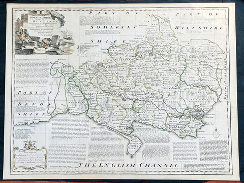
1760 Emanuel Bowen Large English County Map of Dorset Shire
- Title : An Accurate Map of Dorsetshire, Divided into its Hundreds. Drawn from the best Authorities, assisted by the most approved Maps and Charts with various Improvements illustrated with Historical Extracts relative to its Natural Produce, Manufactures, Trade, present state of it’s principal Towns and Sea Ports, by Eman Bowen geographer to His Majesty.
- Date : 1760
- Size: 29in x 22 1/2in (750mm x 570mm)
- Condition: (A+) Fine Condition
- Ref: 35614
Description:
This large original beautifully hand coloured antique map of the English County of Dorset Shire by Emmanuel Bowen was published by Carrington Bowles in the 1760 edition of The Large English Atlas. (Ref: Tooley; M&B)
General Definitions:
Paper thickness and quality: - Heavy and stable
Paper color : - off white
Age of map color: - Original
Colors used: - Pink, blue, green, yellow
General color appearance: - Authentic
Paper size: - 29in x 22 1/2in (750mm x 570mm)
Plate size: - 27 1/2in x 21 1/2in (700mm x 545mm)
Margins: - Min 1/2in (12mm)
Imperfections:
Margins: - Light age toning in margins
Plate area: - None
Verso: - None
Background:
The Large English Atlas was, as its name suggests, a large folio series of county maps conceived in about 1749 but, because of financial problems, not completed until 1760. Hodson describes the atlas as by far the most important eighteenth-century English atlas to be published before the appearance of John Carys New And Correct English Atlas in 1787. Earlier county atlases were predominantly derivative, using old survey work, many in fact, traceable back to Saxtons work of the sixteenth century. The Large English Atlas maps were drawn from the most up-to-date surveys, and so mark an important stage in the development of the county atlas (Hodson). Through its commercial success, this atlas encouraged a new generation of county atlases, of both large and small scales, but of greater precision than before. The maps, drawn either by Emanuel Bowen or Thomas Kitchin, are finely produced. A particular feature is the vast amount of additional detail engraved in the blank areas around the map, lists of the landed gentry, descriptions of the towns, produce and other notable features of each county, and in some cases, fine insets of the county town. All have elaborate title cartouches, illustrating the produce of the county, rural scenes and so on, many signed by Antony Walker Jr. Besides the separately published multi-sheet maps of various counties these are the most detailed and most interesting county maps of the eighteenth century.