
Profile : Abraham Ortel, better known as Abraham Ortelius, was a Flemish cartographer and geographer, widely regarded as one of the greatest cartographers of his time. Born in Antwerp, Belgium, Ortelius was interested in geography and cartography from a young age. He initially worked as a map colorist before eventually establishing his own publishing house and becoming one of the leading cartographers of the 16th century.
Ortelius is best known for his atlas, "Theatrum Orbis Terrarum" ("Theatre of the World"), which was first published in 1570 and became one of the most influential works in the history of cartography. The atlas contained a collection of maps that were accurate, detailed, and beautifully designed, making it popular among scholars, explorers, and merchants.
In addition to his cartographic work, Ortelius was also an avid collector of maps, books, and manuscripts. He traveled extensively throughout Europe, visiting libraries and meeting with other cartographers and geographers to exchange information and ideas.
Ortelius received numerous honors and accolades during his lifetime, including being appointed geographer to the king of Spain and being elected a member of the prestigious Antwerp Guild of St. Luke. Today, his contributions to the field of cartography are still celebrated, and his maps and atlases are highly prized by collectors and scholars alike.
1570 – 1612
Theatrum Orbis Terrarum Between these years the Theatrum was re-issued in 42 editions with 5 supplements with text in Latin, Dutch, German, French, Spanish, Italian and English. The English edition was published in 1606 by John Norton, the maps being printed in Antwerp and the text added in London. Three years after Ortelius died in 1598, his heirs transferred publication rights to Jan Baptiste Vrients who produced the later editions until he died in 1612
1577 - 85
Spiegel der Werelt (8vo) Maps from the Theatrum, reduced in size, engraved by Philip Galle: text by Pieter Heyns. 6 editions with Dutch, French and Latin text. 1588-i 603 Epitome theatri orbis terrarum (12mo/8v0) 11 further editions of the smaller maps with an increasing number of maps with text also in Italian and English (1603). i6oi-i 2 7 further editions with improved engravings by Arsenius Brothers: text by Michel Coignet in Latin, French, German, Italian and English (1603).
1598 - 1724
Theatro del Mondo (4t0/12mo/24mo) 8 editions with Italian text; plates engraved in Italy. 1579-1606 Parergon Theatri The number of maps included in the Parergon increased from 4 in 1579 to 43 in 1606 with text in Latin, French, Italian, German and English (1606) 1624 Re-issued in Antwerp as a separate publication by Balthasar Moretus. This edition included a reproduction of the Peutinger table
Abraham Ortelius (1)
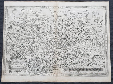
1575 Abraham Ortelius Antique Map Obersachsen, Meissen and Thuringen, Germany
- Title : Saxoniae Misniae, Thuringiae, Nova Exactissimaq Descriptio
- Size: 20 1/2in x 15 1/2in (520mm x 390mm)
- Condition: (A+) Fine Condition
- Date : 1587
- Ref #: 30032
Description:
These original copper-plate engraved antique map of the Obersachsen, Meissen and Thuringen regions of Germany was published in the 1575 French edition of Abraham Ortelius Atlas Theatrum Orbis Terrarum.
General Definitions:
Paper thickness and quality: - Heavy and stable
Paper color : - off white
Age of map color: -
Colors used: -
General color appearance: -
Paper size: - 20 1/2in x 15 1/2in (520mm x 390mm)
Plate size: - 20in x 13 1/2in (510mm x 345mm)
Margins: - Min 1/4in (4mm)
Imperfections:
Margins: - Light soiling
Plate area: - None
Verso: - Soiling
Background:
Ortelius regional map of Germany, showing the area between Berlin and Braunschweig in the north, to Prague in the south and Silesia in the east. With Chemnitz, Dresden, Leipzig, Wittenberg and Erfurt