
Profile : Abraham Ortel, better known as Abraham Ortelius, was a Flemish cartographer and geographer, widely regarded as one of the greatest cartographers of his time. Born in Antwerp, Belgium, Ortelius was interested in geography and cartography from a young age. He initially worked as a map colorist before eventually establishing his own publishing house and becoming one of the leading cartographers of the 16th century.
Ortelius is best known for his atlas, "Theatrum Orbis Terrarum" ("Theatre of the World"), which was first published in 1570 and became one of the most influential works in the history of cartography. The atlas contained a collection of maps that were accurate, detailed, and beautifully designed, making it popular among scholars, explorers, and merchants.
In addition to his cartographic work, Ortelius was also an avid collector of maps, books, and manuscripts. He traveled extensively throughout Europe, visiting libraries and meeting with other cartographers and geographers to exchange information and ideas.
Ortelius received numerous honors and accolades during his lifetime, including being appointed geographer to the king of Spain and being elected a member of the prestigious Antwerp Guild of St. Luke. Today, his contributions to the field of cartography are still celebrated, and his maps and atlases are highly prized by collectors and scholars alike.
1570 – 1612
Theatrum Orbis Terrarum Between these years the Theatrum was re-issued in 42 editions with 5 supplements with text in Latin, Dutch, German, French, Spanish, Italian and English. The English edition was published in 1606 by John Norton, the maps being printed in Antwerp and the text added in London. Three years after Ortelius died in 1598, his heirs transferred publication rights to Jan Baptiste Vrients who produced the later editions until he died in 1612
1577 - 85
Spiegel der Werelt (8vo) Maps from the Theatrum, reduced in size, engraved by Philip Galle: text by Pieter Heyns. 6 editions with Dutch, French and Latin text. 1588-i 603 Epitome theatri orbis terrarum (12mo/8v0) 11 further editions of the smaller maps with an increasing number of maps with text also in Italian and English (1603). i6oi-i 2 7 further editions with improved engravings by Arsenius Brothers: text by Michel Coignet in Latin, French, German, Italian and English (1603).
1598 - 1724
Theatro del Mondo (4t0/12mo/24mo) 8 editions with Italian text; plates engraved in Italy. 1579-1606 Parergon Theatri The number of maps included in the Parergon increased from 4 in 1579 to 43 in 1606 with text in Latin, French, Italian, German and English (1606) 1624 Re-issued in Antwerp as a separate publication by Balthasar Moretus. This edition included a reproduction of the Peutinger table
Abraham Ortelius (16)
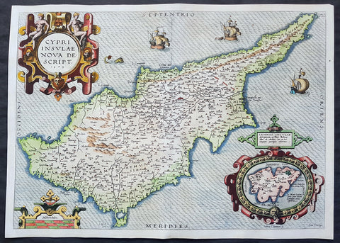
1573 Abraham Ortelius Original Antique 1st Edition Map of The Island of Cyprus
- Title : Cypri Insulae Nova Descript 1573
- Date : 1573
- Size: 20 3/4in x 15in (525mm x 382mm)
- Ref #: 70794
- Condition: (A+) Fine Condition
Description:
This extremely handsome and much sort after original antique map of the Island of Cyprus was published by Abraham Ortelius in 1573. There were a total of 6275 of these maps published between 1573 and 1641, with approx. 10% surviving to this day.
This actual map is a true first edition or state (1573IG39A), of 3 states, with German text & page number 39A on the verso.
General Definitions:
Paper thickness and quality: - Heavy and stable
Paper color : - off white
Age of map color: - Original
Colors used: - Yellow, green, blue, pink
General color appearance: - Authentic
Paper size: - 20 3/4in x 15in (525mm x 382mm)
Plate size: - 19 3/4in x 14in (500mm x 355mm)
Margins: - Min 1/2in (12mm)
Imperfections:
Margins: - None
Plate area: - None
Verso: - None
Background:
A milestone in the history of the cartography of Cyprus, based on a 1570 map by Giacomo Franco. The map is embellished by sailing ships and a sea monster, bearing a map of the Greek Island of Lemnos in an inset mp at bottom right, based on the written account by Pierre Belon in 1555. Signed in the plate by the Dutch engraver Joannes van Doetecum
Cyprus is an island country in the Eastern Mediterranean and the third largest and third most populous island in the Mediterranean. It is located south of Turkey, west of Syria and Lebanon, northwest of Israel, north of Egypt, and southeast of Greece.
The earliest known human activity on the island dates to around the 10th millennium BC. Archaeological remains from this period include the well-preserved Neolithic village of Khirokitia, and Cyprus is home to some of the oldest water wells in the world. Cyprus was settled by Mycenaean Greeksin two waves in the 2nd millennium BC. As a strategic location in the Middle East, it was subsequently occupied by several major powers, including the empires of the Assyrians, Egyptians and Persians, from whom the island was seized in 333 BC by Alexander the Great. Subsequent rule by Ptolemaic Egypt, the Classical and Eastern Roman Empire, Arabcaliphates for a short period, the French Lusignan dynasty and the Venetians, was followed by over three centuries of Ottoman rule between 1571 and 1878.
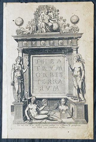
1574 Abraham Ortelius Antique Atlas Title Page for Theatrum Orbis Terrarum.
- Title : Theatrum Orbis Terrarum
- Size: 15 3/4in x 10 3/4in (400mm x 270mm)
- Condition: (A+) Fine Condition
- Date : 1574
- Ref #: 32019
Description:
These original copper-plate engraved antique 1st edition Title Page was published in the 1574 edition of Abraham Ortelius Atlas Theatrum Orbis Terrarum.
General Definitions:
Paper thickness and quality: - Heavy and stable
Paper color : - off white
Age of map color: -
Colors used: -
General color appearance: -
Paper size: - 15 3/4in x 10 3/4in (400mm x 270mm)
Plate size: - 15 3/4in x 10 3/4in (400mm x 270mm)
Margins: - Min 1/2in (12mm)
Imperfections:
Margins: - Light soiling
Plate area: - Light soiling
Verso: - Light soiling
Background:
The title page has on the verso the Epigram of 16 lines. First edition of the first atlas of the world. From Koeman: The unique position held by Ortelius Theatrum in the history of cartography is to be attributed primarily to its qualification as the worlds first regularly produced atlas. Its great commercial success enabled it to make so great a contribution to geographical culture throughout Europe in the later 16th century. (Skelton). Shape and contents set the standards for later atlases, when the centre of the map-trade moved from Antwerp to Amsterdam. The characteristic feature of the Theatrum is, that it consists of two elements, forming a unitary whole: text and maps. This concept for a Theatre of the world was followed through the 17th century. Before Ortelius, no one and done this and thus, the chorus of praise which arose as a result of this - and the excellent text - was far from slight... Another important aspect of the Theatrum is that it was the first undertaking of its kind to reduce the best available maps to a uniform format. To that end, maps of various formats and styles had to be generalized just like the modern atlas-publisher of today would do. In selecting maps for his compilation, Ortelius was guided by his critical spirit and his encyclopaedic knowledge of maps. But Ortelius did more that the atlas-makers of today: he mentioned the names of the authors of the original maps and added a great many names of other cartographers and geographers to it... Abraham Ortelius drew all his maps in manuscript before passing them to the engravers... Ortelius stated that nearly all the plates were cut by Frans Hogenberg and his assistants. The Theatrum went through many editions in Latin, German, French, Dutch, Spanish, English, and Italian. Van der Krogt lists 37 editions, with the last edition published in 1641, long after Ortelius death in 1598

1574 Abraham Ortelius Antique Map of Spain & Portugal - Regni Hispaniae
- Title : Regni Hispaniae Post Omnium Editiones Locvplessima Descriptio
- Ref #: 82078
- Size: 21 1/2in x 16in (545mm x 405mm)
- Date : 1574
- Condition: (A) Very Good Condition
Description:
This beautifully hand coloured original antique map of Spain & Portugal, 1st edition - based on the cartographic work of Charles de L Escluse - was published by Abraham Ortelius in the 1574 Latin edition of Theatrum Orbis Terrarum.
Ortelius published a total of 8175 of this map between 1570 to 1641 in 4 States. According to Marcel Van den Broecke there are estimated to be only 155 loose copies in circulation today.
General Definitions:
Paper thickness and quality: - Heavy and stable
Paper color : - off white
Age of map color: - Early
Colors used: - Yellow, green, blue, pink
General color appearance: - Authentic
Paper size: - 21 1/2in x 16in (545mm x 405mm)
Plate size: - 19 1/2in x 15in (495mm x 380mm)
Margins: - Min 1in (25mm)
Imperfections:
Margins: - Small repair to bottom margin
Plate area: - Small repair adjacent to bottom centerfold, no loss
Verso: - Centerfold re-enforced on verso
Background:
Many of the original charts and maps drawn by the first Portuguese and Spanish navigators have survived for the very good reason that, on completion of their voyages, pilots were obliged to hand over their manuscript notes to the Casa da India (founded 1504) in Lisbon or to the equivalent Casa de Contrataci6n de las Indias (founded 1504) in Seville. The clear intention was to maintain secrecy over new discoveries and control over the distribution of cartographic material, not always successfully, as it happened; pilots and navigators seem to have changed allegiance with impunity and, in consequence, many of the earliest and most informative charts were compiled as far away as Genoa, Venice, Florence and Ancona, presumably from sources outside the Portuguese and Spanish \'Casas\'.It is apparent that few manuscripts reached the printing stage and, indeed, are so rare that any study of them must be regarded as a specialist subject. (Ref Tooley M&B)
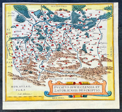
1574 Ortelius Antique Map of Oswięcim & Zator Regions Southern Poland Carpathian
- Title : Ducatus Oswieczensis, et Zatoriensis, Descriptio
- Ref #: 35633
-
Condition: (A+) Fine Condition
- Size: 10 1/2in x 9 1/2in (265mm x 240mm)
- Date : 1574
- Price: $149US
Description:
This original hand coloured copper plate engraved antique map, from a page of three maps, of the Oswięcim and Zator Duchies in South Poland by the Carpathian Mountains, by Abraham Ortelius was published in the 1574 edition of Theatrum Orbis Terrarum
General Definitions:
Paper thickness and quality: - Heavy and stable
Paper color : - off white
Age of map color: - Original
Colors used: - Yellow, green, blue, pink
General color appearance: - Authentic
Paper size: - 10 1/2in x 9 1/2in (265mm x 240mm)
Plate size: - 10 1/2in x 9 1/2in (265mm x 240mm)
Margins: - Min 1/4in (5mm)
Imperfections:
Margins: - None
Plate area: - None
Verso: - None
Background:
Oswięcim has a rich history, which dates back to the early days of Polish statehood. It is one of the oldest castellan gords in Poland. Following the Fragmentation of Poland in 1138, Duke Casimir II the Just attached the town to the Duchy of Opole in c. 1179 for his younger brother Mieszko I Tanglefoot, Duke of Opole and Raciborz. The town was destroyed in 1241 during the Mongol invasion of Poland. Around 1272 the newly rebuilt Oswięcim was granted a municipal charter modeled on those of Lwowek Sląski (a Polish variation of the Magdeburg Law). The charter was confirmed on 3 September 1291. In 1281, the Land of Oswięcim became part of the newly established Duchy of Cieszyn, and in c. 1315, an independent Duchy of Oswięcim was established. In 1327, John I, Duke of Oswięcim joined his Duchy with the Duchy of Zator and, soon afterwards, his state became a vassal of the Kingdom of Bohemia, where it remained for over a century. In 1445, the Duchy was divided into three separate entities – the Duchies of Oswięcim, Zator and Toszek. In 1457 Polish King Casimir IV Jagiellon bought the rights to Oswięcim. On 25 February 1564, King Sigismund II Augustus issued a bill integrating the former Duchies of Oswięcim and Zator into the Kingdom of Poland. Both lands were attached to the Krakow Voivodeship, forming the Silesian County. The town later became one of the centers of Protestant culture in Poland.
Like other towns of Lesser Poland, Oswięcim prospered in the period known as Polish Golden Age. This period came to an abrupt end in 1655, during the catastrophic Swedish invasion of Poland. Oswięcim was burned and afterward, the town declined, and in 1772 (see Partitions of Poland), it was annexed by the Habsburg Empire, as part of the Kingdom of Galicia and Lodomeria, where it remained until late 1918. After the 1815 Congress of Vienna, the town was close to the borders of both Russian-controlled Congress Poland, and the Kingdom of Prussia. In the 1866 war between Austria and the Prussian-led North German Confederation, a cavalry skirmish was fought at the town, in which an Austrian force defeated a Prussian incursion.
Please note all items auctioned are genuine, we do not sell reproductions. A Certificate of Authenticity (COA) can be issued on request.
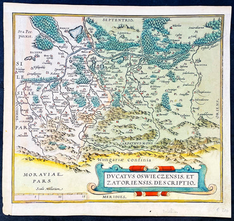
1574 Ortelius Antique Map of Oswięcim & Zator Regions Southern Poland Carpathian
- Title : Ducatus Oswieczensis, et Zatoriensis, Descriptio
- Ref #: 35634
-
Condition: (A+) Fine Condition
- Size: 10 1/2in x 9 1/2in (265mm x 240mm)
- Date : 1574
- Price: $149US
Description:
This original hand coloured copper plate engraved antique map, from a page of three maps, of the Oswięcim and Zator Duchies in South Poland by the Carpathian Mountains, by Abraham Ortelius was published in the 1574 edition of Theatrum Orbis Terrarum
General Definitions:
Paper thickness and quality: - Heavy and stable
Paper color : - off white
Age of map color: - Original
Colors used: - Yellow, green, blue, pink
General color appearance: - Authentic
Paper size: - 10 1/2in x 9 1/2in (265mm x 240mm)
Plate size: - 10 1/2in x 9 1/2in (265mm x 240mm)
Margins: - Min 1/4in (5mm)
Imperfections:
Margins: - None
Plate area: - None
Verso: - None
Background:
Oswięcim has a rich history, which dates back to the early days of Polish statehood. It is one of the oldest castellan gords in Poland. Following the Fragmentation of Poland in 1138, Duke Casimir II the Just attached the town to the Duchy of Opole in c. 1179 for his younger brother Mieszko I Tanglefoot, Duke of Opole and Raciborz. The town was destroyed in 1241 during the Mongol invasion of Poland. Around 1272 the newly rebuilt Oswięcim was granted a municipal charter modeled on those of Lwowek Sląski (a Polish variation of the Magdeburg Law). The charter was confirmed on 3 September 1291. In 1281, the Land of Oswięcim became part of the newly established Duchy of Cieszyn, and in c. 1315, an independent Duchy of Oswięcim was established. In 1327, John I, Duke of Oswięcim joined his Duchy with the Duchy of Zator and, soon afterwards, his state became a vassal of the Kingdom of Bohemia, where it remained for over a century. In 1445, the Duchy was divided into three separate entities – the Duchies of Oswięcim, Zator and Toszek. In 1457 Polish King Casimir IV Jagiellon bought the rights to Oswięcim. On 25 February 1564, King Sigismund II Augustus issued a bill integrating the former Duchies of Oswięcim and Zator into the Kingdom of Poland. Both lands were attached to the Krakow Voivodeship, forming the Silesian County. The town later became one of the centers of Protestant culture in Poland.
Like other towns of Lesser Poland, Oswięcim prospered in the period known as Polish Golden Age. This period came to an abrupt end in 1655, during the catastrophic Swedish invasion of Poland. Oswięcim was burned and afterward, the town declined, and in 1772 (see Partitions of Poland), it was annexed by the Habsburg Empire, as part of the Kingdom of Galicia and Lodomeria, where it remained until late 1918. After the 1815 Congress of Vienna, the town was close to the borders of both Russian-controlled Congress Poland, and the Kingdom of Prussia. In the 1866 war between Austria and the Prussian-led North German Confederation, a cavalry skirmish was fought at the town, in which an Austrian force defeated a Prussian incursion.
Please note all items auctioned are genuine, we do not sell reproductions. A Certificate of Authenticity (COA) can be issued on request.
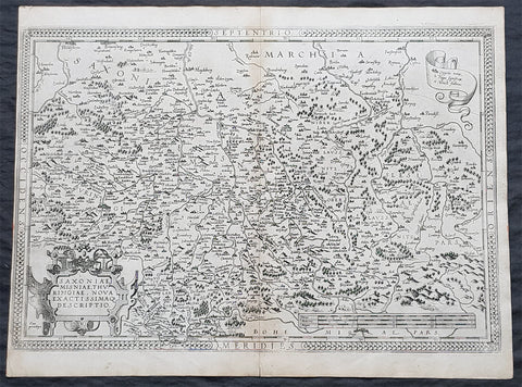
1575 Abraham Ortelius Antique Map Obersachsen, Meissen and Thuringen, Germany
- Title : Saxoniae Misniae, Thuringiae, Nova Exactissimaq Descriptio
- Size: 20 1/2in x 15 1/2in (520mm x 390mm)
- Condition: (A+) Fine Condition
- Date : 1587
- Ref #: 30032
Description:
These original copper-plate engraved antique map of the Obersachsen, Meissen and Thuringen regions of Germany was published in the 1575 French edition of Abraham Ortelius Atlas Theatrum Orbis Terrarum.
General Definitions:
Paper thickness and quality: - Heavy and stable
Paper color : - off white
Age of map color: -
Colors used: -
General color appearance: -
Paper size: - 20 1/2in x 15 1/2in (520mm x 390mm)
Plate size: - 20in x 13 1/2in (510mm x 345mm)
Margins: - Min 1/4in (4mm)
Imperfections:
Margins: - Light soiling
Plate area: - None
Verso: - Soiling
Background:
Ortelius regional map of Germany, showing the area between Berlin and Braunschweig in the north, to Prague in the south and Silesia in the east. With Chemnitz, Dresden, Leipzig, Wittenberg and Erfurt
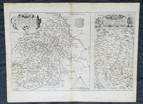
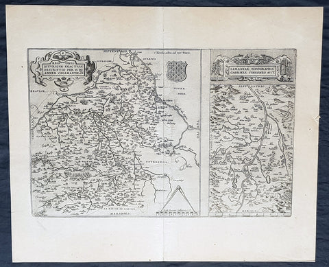
1575 Abraham Ortelius Antique Maps of Loire Valley, River & Alliers River France
- Title : Regionis Biturigum Exactiss Descriptio per D. Ioannem Calamaeum. Limaniae Topographia Gabriele Symeoneo Auct. [The region of Berry exactly described by Jean Chameau. The topography around of Lyons by Gabriel Symeon]
- Size: 22in x 18 1/2in (560mm x 470mm)
- Condition: (A+) Fine Condition
- Date : 1575
- Ref #: 30021
Description:
These original copper-plate engraved antique maps, the first of the Loire River & Valley and the second of the Alliers River, was published by Abraham Ortelius in the 1575 French edition of Theatrum Orbis Terrarum.
These are two rare regional Abraham Ortelius maps on a single folio sheet. The Left Map, centered on Bourges, depicts the Loire Valley region from Gian to St. Sebastian in the south and from Le Blanc east as far as Nevers. Several important cities are noted, including Argenton, Neuers (Nevers), Bourges, Le Blang en Berry, Romarantin, Vierzon, Chasteau Neuf, and others. The right map follows the flow of the Alliers River from Randan to Gondole. Important cities, including Beauregard, Cleremont, among several others are noted. Each map features a decorative cartouche and details their respective regions in wonderful detail with attention to forests, cities, rivers and villages.
General Definitions:
Paper thickness and quality: - Heavy and stable
Paper color : - off white
Age of map color: -
Colors used: -
General color appearance: -
Paper size: - 22in x 18 1/2in (560mm x 470mm)
Plate size: - 19 1/2in x 12 1/2in (490mm x 310mm)
Margins: - Min 1in (25mm)
Imperfections:
Margins: - Light soiling
Plate area: - None
Verso: - Soiling
Background:
The Loire Valley spanning 280 kilometres , is located in the middle stretch of the Loire River in central France, in both the administrative regions Pays de la Loire and Centre-Val de Loire. The area of the Loire Valley comprises about 800 square kilometres. It is referred to as the Cradle of the French and the Garden of France due to the abundance of vineyards, fruit orchards (such as cherries), and artichoke, and asparagus fields, which line the banks of the river. Notable for its historic towns, architecture, and wines, the valley has been inhabited since the Middle Palaeolithic period.
The Allier is a river in central France. It is a left tributary of the Loire. Its source is in the Massif Central, in the Lozère department, east of Mende. It flows generally north. It joins the Loire west of the city of Nevers.
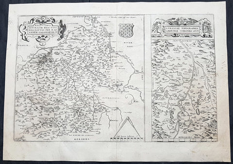
1575 Abraham Ortelius Antique Maps of Loire Valley, River & Alliers River France
- Title : Regionis Biturigum Exactiss Descriptio per D. Ioannem Calamaeum. Limaniae Topographia Gabriele Symeoneo Auct. [The region of Berry exactly described by Jean Chameau. The topography around of Lyons by Gabriel Symeon]
- Size: 21in x 19 1/2in (535mm x 495mm)
- Condition: (A+) Fine Condition
- Date : 1575
- Ref #: 50228
Description:
These original copper-plate engraved antique maps, the first of the Loire River & Valley and the second of the Alliers River, was published by Abraham Ortelius in the 1575 French edition of Theatrum Orbis Terrarum.
These are two rare regional Abraham Ortelius maps on a single folio sheet. The Left Map, centered on Bourges, depicts the Loire Valley region from Gian to St. Sebastian in the south and from Le Blanc east as far as Nevers. Several important cities are noted, including Argenton, Neuers (Nevers), Bourges, Le Blang en Berry, Romarantin, Vierzon, Chasteau Neuf, and others. The right map follows the flow of the Alliers River from Randan to Gondole. Important cities, including Beauregard, Cleremont, among several others are noted. Each map features a decorative cartouche and details their respective regions in wonderful detail with attention to forests, cities, rivers and villages.
General Definitions:
Paper thickness and quality: - Heavy and stable
Paper color : - off white
Age of map color: -
Colors used: -
General color appearance: -
Paper size: - 21in x 19 1/2in (535mm x 495mm)
Plate size: - 19 1/2in x 12 1/2in (490mm x 310mm)
Margins: - Min 1/8in (2mm)
Imperfections:
Margins: - None
Plate area: - None
Verso: - None
Background:
The Loire Valley spanning 280 kilometres , is located in the middle stretch of the Loire River in central France, in both the administrative regions Pays de la Loire and Centre-Val de Loire. The area of the Loire Valley comprises about 800 square kilometres. It is referred to as the Cradle of the French and the Garden of France due to the abundance of vineyards, fruit orchards (such as cherries), and artichoke, and asparagus fields, which line the banks of the river. Notable for its historic towns, architecture, and wines, the valley has been inhabited since the Middle Palaeolithic period.
The Allier is a river in central France. It is a left tributary of the Loire. Its source is in the Massif Central, in the Lozère department, east of Mende. It flows generally north. It joins the Loire west of the city of Nevers.
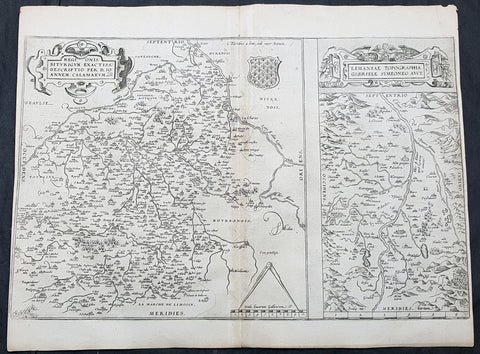
1575 Abraham Ortelius Antique Maps of Loire Valley, River & Alliers River France
- Title : Regionis Biturigum Exactiss Descriptio per D. Ioannem Calamaeum. Limaniae Topographia Gabriele Symeoneo Auct. [The region of Berry exactly described by Jean Chameau. The topography around of Lyons by Gabriel Symeon]
- Size: 19in x 15in (485mm x 380mm)
- Condition: (A) Very Condition
- Date : 1575
- Ref #: 30993
Description:
These original copper-plate engraved antique maps, the first of the Loire River & Valley and the second of the Alliers River, was published by Abraham Ortelius in the 1575 French edition of Theatrum Orbis Terrarum.
These are two rare regional Abraham Ortelius maps on a single folio sheet. The Left Map, centered on Bourges, depicts the Loire Valley region from Gian to St. Sebastian in the south and from Le Blanc east as far as Nevers. Several important cities are noted, including Argenton, Neuers (Nevers), Bourges, Le Blang en Berry, Romarantin, Vierzon, Chasteau Neuf, and others. The right map follows the flow of the Alliers River from Randan to Gondole. Important cities, including Beauregard, Cleremont, among several others are noted. Each map features a decorative cartouche and details their respective regions in wonderful detail with attention to forests, cities, rivers and villages.
General Definitions:
Paper thickness and quality: - Heavy and stable
Paper color : - off white
Age of map color: -
Colors used: -
General color appearance: -
Paper size: - 19in x 15in (485mm x 380mm)
Plate size: - 19 1/2in x 12 1/2in (490mm x 310mm)
Margins: - Min 1/8in (2mm)
Imperfections:
Margins: - L&R margins cropped close to border
Plate area: - Light age toning along centerfold
Verso: - Soiling
Background:
The Loire Valley spanning 280 kilometres , is located in the middle stretch of the Loire River in central France, in both the administrative regions Pays de la Loire and Centre-Val de Loire. The area of the Loire Valley comprises about 800 square kilometres. It is referred to as the Cradle of the French and the Garden of France due to the abundance of vineyards, fruit orchards (such as cherries), and artichoke, and asparagus fields, which line the banks of the river. Notable for its historic towns, architecture, and wines, the valley has been inhabited since the Middle Palaeolithic period.
The Allier is a river in central France. It is a left tributary of the Loire. Its source is in the Massif Central, in the Lozère department, east of Mende. It flows generally north. It joins the Loire west of the city of Nevers.
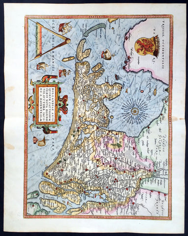
1579 Abraham Ortelius Antique Map of Holland - Hollandia Antiquorum Catthorum
- Title : Hollandia Antiquorum Catthorum Sedis Nova Descriptio, Avctore Iacobo A Daventria
- Ref #: 50664
- Size: 21 1/2in x 17in (550mm x 430mm)
- Date : 1579
- Condition: (A+) Fine Condition
Description:
This beautifully hand coloured original antique map of Holland, 1st edition - based on the cartographic works of Jacob van Deventer - was published by Abraham Ortelius in the 1579 Latin edition of Theatrum Orbis Terrarum.
Ortelius published a total of 7300 of this map between 1570 to 1641 from 3 States:
1570-1584 state 1
1587-1595 State 2
1598-1641 State3.
According to Marcel Van dem Broecke there are estimated to be only 140 loose copies in circulation.
Background: It would be hard to imagine a more inauspicious period for a nation's cultural development than the years between 1520 and 1600 in the Low Countries. Under the harsh domination of the Spanish Emperors, facing fanatical religious persecution and the threat of the Inquisition, the constant presence of foreign troops and even the destruction of some of their cities, the Dutch, nevertheless, in 1581 contrived to break their subservience to Spain and form their own federation. Belgium, being mainly Catholic, remained within the orbit of the Empire though henceforward was recognized as a separate state. In such circumstances there would seem to have been little chance for growth of a national entity in the small Northern Provinces but, on the contrary, under the leadership of Amsterdam, their banking and commercial enterprise soon dominated Europe. The attempt by Philip II to eliminate their control of European coastal trade by the use of Portuguese craft inspired the Dutch, first, to seek a North East passage to India and Asia and then, failing that, to challenge Spanish and Portuguese power directly, not only in European waters but also in the East, and eventually to eclipse it. English attempts to gain a foothold in the Indies were bitterly opposed and the English turned their attention to India where only a handful of Dutch settlements existed.
In spite of the turmoil arising out of these events, first Antwerp and then Amsterdam became centres of the arts and their cartographers, engravers and printers produced magnificent maps and charts of every kind which many claim have never been surpassed. Later in this chapter an account is given of Gerard Mercator, who studied at Louvain under Gemma Frisius, the Dutch astronomer and mathematician, and later moved to Duisburg in the Rhineland where most of his major work was carried Out. There he produced globes, maps of Europe, the British Isles and the famous World Map using his newly invented method of projection, all of which were widely copied by most of the cartographers of the day. The first part of his Atlas - the word chosen by Mercator to describe a collection of maps - was published in 1585, the second in 1589, and the third in 1595, a year after his death.
Other great names of the time were Abraham Ortelius, native of Antwerp, famous for his world atlas, Theatrum Orbis Terrarum, issued in 1570; Waghenaer, noted for his sea atlases of 1584 and 1592, Gerard de Jode and Jodocus and Henricus Hondius, followed in the next century by W. J. Blaeu and his sons and Jan Jansson. The Blaeu and Jansson establishments were noted mainly for land atlases but their sea atlases and pilot books were also published in numerous editions which went some way to meeting the rising demand for aids to navigation in European and Mediterranean waters. Their productions were challenged by other, smaller publishers specializing in such works, Jacob Colom, Anthonie Jacobsz, Pieter Goos, Hendrick Doncker, to mention a few, and, later, the charts issued by the van Keulen family and their descendants covered practically all the seas of the known world. As we reach the second half of the seventeenth century the details of publication of these sea atlases and pilot books become more and more interwoven and complicated. Not infrequently the same charts were issued under the imprint of different publishers; at death the engraved plates were sold or passed to their successors and were re-issued, with minor alterations and often without acknowledgement to the originator, all of which adds to problems of identification. Although, in this period, charts of every kind must have been issued in great quantity, good copies are now hard to find.
By about the year 1700 Dutch sea power and influence was waning and although their pilot books and charts remained much in demand for many years to come, leadership in the production of land atlases passed into the hands of the more scientific French cartographers who, in their turn, dominated the map trade for most of the following century.
Atlas Background: For the first time, in 1570, all the elements of the modern Atlas were brought to publication in Abraham Ortelius' Theatrum Orbis Terrarum. This substantial undertaking assembled fifty-three of the best available maps of the world by the most renowned and up to date geographers.
Unlike earlier compositions, such as the Italian composite or "Lafreri" Atlases, each of Ortelius' maps was engraved specifically for his Atlas according to uniform format. Through its launching, pre-eminence in map publishing was transferred from Italy to the Netherlands, leading to over a hundred years of Dutch supremacy in all facts of cartographical production.
There were a total of 7300 copies of Theatrum published between 1570 - 1612 from 31 editions. (Ref: Van Den Broecke; Tooley)
General Description:
Paper thickness and quality: - Light and stable
Paper color: - off white
Age of map color: - Early color
Colors used: - Yellow, green, blue, pink
General color appearance: - Authentic
Paper size: - 21 1/2in x 17in (550mm x 430mm)
Plate size: - 19 1/2in x 14in (495mm x 355mm)
Margins: - Min 1in (25mm)
Imperfections:
Margins: - Light browning in top and bottom margins
Plate area: - None
Verso: - None
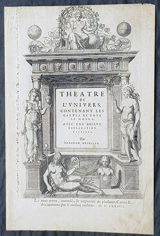
1587 Abraham Ortelius Antique Title Page from the Atlas Theatrum Orbis Terrarum
- Title : Theatre de l univers : contenant les cartes de tout le monde, avec une brieve declaration d icelles par Abraham Ortelius...MDLXXXVII (1587)
- Size: 15 3/4in x 10 3/4in (400mm x 270mm)
- Condition: (A) Very Good Condition
- Date : 1587
- Ref #: 32035
Description:
These original copper-plate engraved antique Title Page, with a quote by Cicero on the verso, was published in the 1587 French edition of Abraham Ortelius Atlas Theatrum Orbis Terrarum.
General Definitions:
Paper thickness and quality: - Heavy and stable
Paper color : - off white
Age of map color: -
Colors used: -
General color appearance: -
Paper size: - 15 3/4in x 10 3/4in (400mm x 270mm)
Plate size: - 15 3/4in x 10 3/4in (400mm x 270mm)
Margins: - Min 1/2in (12mm)
Imperfections:
Margins: - Light soiling, old ink text in left margin
Plate area: - Light soiling
Verso: - Light soiling
Background:
This is the French version of Abraham OrteliusTheatrum orbis terrarum, considered to be the first modern atlas. Ortelius was one of the leading humanists of the Low Countries and was acquainted with many European intellectuals. Theatrum orbis terrarum was incredibly successful, despite being the most expensive book produced in the second half of the sixteenth century. Interest in it was extended by the continued issue of updated versions. Produced during the European Age of Discovery, new editions reflected the latest geographic knowledge, and each version contained new maps and information.
Theatrum orbis terrarum translates as Theatre of the lands of the world. The idea of the world as a theatre is echoed by William Shakespeare in his naming of the Globe theatre, and in Jaquess famous speech in As You Like It, beginning All the worlds a stage, and all the men and women merely players. The influence of Elizabethan exploration and the ideas of new and strange lands and peoples are reflected in many of Shakespeares plays.
The opening double-page spread of the world in this book, engraved by Francis Hogenberg, is among the most widely reproduced early-modern maps. It reflects contemporary theories about what remained undiscovered: Ortelius believed there to be a large southern continent which he named Terra Australis Nondum Cognita, or Southern Land Not Yet Known.
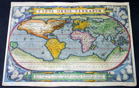
1588 Abraham Ortelius Antique Oval World Map - Rarest Edition, Ort 2:3
- Title : Typus Orbis Terrarum
- Date : 1588
- Condition: (A+) Fine Condition
- Ref: Ort1
- Size: 20in x 14 ½in (510mm x 370mm)
This magnificent original hand coloured copper-plate engraved rare antique Oval World map (Ort 2:3) was engraved by Franciscus (Frans) Hogenberg and was published in the 1588 edition of Abraham Ortelius Atlas <i>Theatrum Orbis Terrarum. </i>
To emphasis how rare this map is consider the following. Ortelius published a total of 6950 of these world maps in 3 states (3250 1st state, 500 2nd state & 3200 3rd state) between 1570 and 1612. Today only 411 are known to have survived. Of these surviving 411 only 14 are of the 2nd state (Ort 2) and of these 14 only 4 are Ort 2:3 state, making this one of the rarest Ortelius maps available on the market at any time. Blank verso.
This map is part of my personal collection and has been framed to Museum quality. I will sell the map with the frame, with additional cost TBN if required.
The map was acquired from Marcel P R van den Broecke - author of Ortelius Atlas Maps - in Holland, collector and dealer and is accompanied by Certificate of Authenticity from Marcel van den Broecke.
Ortelius published 3 World maps over the life of his atlas <i>Theatrum Orbis Terrarum</i>, between 1570 & 1612. These 3 maps are referred to as Ort 1, Ort 2 & Ort 3. Over the life of these maps, necessary changes, repairs & updates were made to the plates, these changes are referred to as states. The first map or Ort 1 required 5 changes, Ort 2 required 3 changes and Ort 3 was changed twice.
This map was published in 1588 and is the last state of Ort 2, identified by the changes to the western South American coastline, whilst still retaining the decorative cloud surround as in Ort1. Ort 3 was changed by removing the cloud surrounds replacing them with medallions and strap-work This is a beautiful map with original hand colouring, on sturdy clean paper with original margins.
Below is a concise list of the states of the map <i>Typus Orbis Terrarum</i>
- 1st edition (Ort 1) – States 1.1 through to 1.5.
A total of 3250 maps from this plate were published between 1570 & 1584. Today it is estimated that there are 236 loose copies in circulation of all 5 states.
- 2nd edition (Ort 2) - States 2.1 through to 2.3.
A total of only 500 maps from this plate were published between 1586 & 1588. Today it is estimated that there are 14 loose copies in circulation of all 3 states.
- 3rd edition (Ort 3) – States 3.1 through to 3.2.
A total of 3200 maps from this plate were published between 1589 & 1612. Today it is estimated that there are 161 loose copies in circulation of both states. (Ref: Van Den Broecke; Tooley; Shirley; Rosenthal)
General Description:
Paper thickness and quality: - Heavy and stable
Paper color: - off white
Age of map color: - Original
Colors used: - Yellow, green, blue, pink
General color appearance: - Authentic
Paper size: - 20in x 14 ½in (510mm x 370mm)
Plate size: - 19 ½in x 13 1/4in (495mm x 340mm)
Margins: - Min ½in (10mm)
Imperfections:
Margins: - Professional 11cm restoration to bottom margin, 1cm into image. Light soiling
Plate area: - Small 2cm sq professional restoration below the ST of Australis
Verso: - Map backed on fine archival Japanese paper
Background:
The Ortelius world map is a simplified one-sheet reduction of Mercators large world map which had appeared the year before. Nearly all the legends, textual panels and decorative features of Mercators map have been omitted; between the oval circumference of the map and the outer frame are now clouds and below, a quotation from Cicero. From surviving correspondence, it is known that Mercator generously encouraged Ortelius to make use of his published research; he also provided him with coordinates of places in America and other newly discovered regions of the world. In the first edition South America retains the unusual bulged south-west coast as drawn by Mercator. There is also a prudent comment adjacent to New Guinea querying whether this large island is part of the southern continent or not.
The original plate, like a number of others in the Atlas, were signed by the engraver Franciscus (Frans) Hogenberg and was used for the first sixteen editions of the Theatrum.
In nearly all places there is text on the reverse of the map in the language indicated but a few copies are known which lack reverse text. Between 1575 and 1579 the plate became cracked along the lower left hand corner. The crack was roughly mended and the whole border of the clouds substantially reworked; editions from 1579 to 1584 contain this revised state 2 of plate 1. Ortelius subsequently produced two further world maps, each slightly improved geographically.
Several of these states co-existed; for instance although plate 3 carries the date 1587, it does not seem to have been issued until 1592. Only one example has been sighted of the first state plate 2 of 1586. State 3 of plate 2 is also uncommon but it re-appears in the British Librarys copy of the Dutch 1598 edition of the Theatrum which, as noted by Koeman, was often made up of earlier stock sheets.
Ortelius map was copied widely, and derivatives were later used to illustrate works by Voisin, Broughton, Maffei, Bell-Forest, Petri, Hakluyt and others.
Cartographical sources were Gerard Mercator 1569 & Gastaldi 1561 world maps and Diego Gutierrez portolan map of the Atlantic.
Next to the list at the bottom of the text, Ortelius mentions in his Catalogues Auctorum the world maps by Peter ab Aggere from Mechelen, Sebastian Cabotus from Venice, Laurentius Fries from Antwerp, Jacobus Gastaldi, Gemma Frisius from Antwerp, Guicciardinus from Antwerp, Doco ab Hemminga Frisius, and Orontius Finæus from Paris.
Background of the Atlas <i>Theatrum Orbis Terrarum</i>
For the first time, in 1570, all the elements of the modern Atlas were brought to publication in Abraham Ortelius Atlas Theatrum Orbis Terrarum. This substantial undertaking assembled fifty-three of the best available maps of the world by the most renowned and up to date geographers.
Unlike earlier compositions, such as the Italian composite or Lafreri Atlases, each of Ortelius maps was engraved specifically for his Atlas according to uniform format. Through its launching, pre-eminence in map publishing was transferred from Italy to the Netherlands, leading to over a hundred years of Dutch supremacy in all facts of cartographical production.
There were a total of 7300 copies of Theatrum published between 1570 - 1612 from 31 editions.
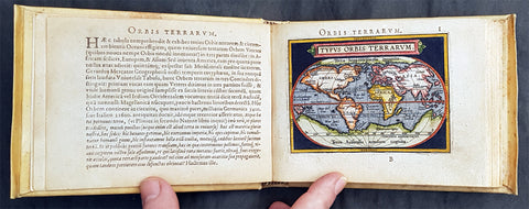
1595 Abraham Ortelius Antique Epitome Atlas with 106 Maps - Rare, Unique & Beautiful
-
Title: Epitome theatri Orteliani...Philippo Gallaeo Arnoldus Cocinx MDXCV
- Ref: 3090
- Condition: (A+) Fine Condition
-
Size: 8vo
- Date: 1595
Description:
This stunning, original antique pocket Epitome Atlas, Theatrum Orbis Terrarum (Theatre of the Orb of the World) - with 106 beautifully hand coloured copper-plate engraved antique maps of the entire 16th century world, by Abraham Ortelius, was published in 1595 - dated on the title page, Latin edition - by Philip Galle.
The atlas has been lovingly and professionally restored with fine vellum binding, end papers. Each page has been lovingly cleaned and faithfully re-coloured and tabbed back into the atlas as originally published. Along with the new end papers, the atlas contains the original dated title page, frontispiece, 6 text pages 109 maps, descriptive text and finally three index pages shown to the left.
A unique opportunity to acquire one of the best, if not the best Epitome Atlas, on the market.
Condition Report
Paper thickness and quality: - Heavy and stable
Paper color: - off white
Age of map color: - Later & early coloring
Colors used: - Yellow, green, red, pink, blue, black
General color appearance: - Authentic and fresh
Atlas size: - 8vo
Map sizes: - 5 3/4in x 4in (145mm x 100mm)
Imperfections:
Margins: None
Plate area: - Very light ink notations on title and Psalm pages, light age toning on a few pages
Verso: - None
Background: The pocket versions, or Epitome, of Abraham Ortelius folio Atlas Theatrum Orbis Terrarum was published by Philip Galle with text by Pieter Heyns. Between 1577 & 1598 Galle issued 11 editions, of which 10 editions were printed by Christopher Platin , with this lone edition printed by Arnoldus Coninx in 1595,making it an extremely rare & unique item. .
The Dutch edition published by Heyn's son Zacharias in 1596, was a re-issue of of the 1583 edition. In addition to the Dutch, French, Latin & Italian editions an English one was produced. The maps for the English edition, the last from Galles map plates, were printed in Antwerp and shipped to London for publication by John Norton in 1602.
The first two editions, of Epitome, contained sixty-six miniatures and six small folding maps including one of the world dated 1574. They were all rather crudely drawn and engraved by Galle, with narrow decorated borders. From 1583 he gradually introduced a new set of maps, adding quality and quantity replacing the originals until they had grown to 123 by 1598.
Theatrum Orbis Terrarum (Theatre of the Orb of the World) is considered to be the first true modern atlas. Written by Abraham Ortelius, strongly encouraged by Gillis Hooftman and originally printed on 20 May 1570 in Antwerp, it consisted of a collection of uniform map sheets and supporting text bound to form a book for which copper printing plates were specifically engraved. The Ortelius atlas is sometimes referred to as the summary of sixteenth-century cartography. The publication of the Theatrum Orbis Terrarum (1570) is often considered as the official beginning of the Golden Age of Netherlandish cartography (approximately 1570s–1670s) (Ref: King; Van Den Broecke; Tooley)

1598 J Moretus & A Ortelius 1st Edition of The Peutinger Tables, Ancient Roman Empire Maps x 4
- Title : Tabula Peutingeriana. Tabula itineraria ex illustri Peutingerorum Bibliotheca quae Augusta Vindel. est. Beneficio Marco Velseri septemviri Augustani in lucem edita.
- Size: 22in x 20in (560mm x 510mm) each
- Condition: (A+) Fine Condition
- Date : 1598
- Ref #: 50519, 50520, 50521, 50522
Description:
For three decades, locating rare & unusual and maps has been one our main goals and I believe with the following maps we have reach a milestone. The following maps originate from the oldest direct linage of any maps we have offered, going back to the height of the Roman Empire. These are some of the rarest and most fascinating maps it has been my pleasure to offer.
In 1265 a Monk, in the German city of Colmar produced a hand written map, on parchment, of the imperial highways and cities of the ancient Roman world. When joined, the result was a scroll measuring 6.75m long & 34cm wide, covering an area from southeast England to present day Sri-Lanka. That map of 1265 was copied from an earlier 4th or 5th century map, itself copied from a 2nd century map that originated from a 1st century BC map from Marcus Vipsanius Agrippa, a Roman General & architect. When Agrippa died in 12BC his map was engraved in marble and displayed in the Porticus Vipsania in the Campus Agrippae area in Rome.
In 1494 the German Scholar, Conrad Celtes, discovered the Colmar scroll in a library, in the city of Worms. After his death in 1508, Celtes bequeathed the scroll to Konrad Peutinger, after whom the map is named. The scroll was kept in the Peutinger family until it was purchased by Prince Eugene of Savoy in 1714 and finally purchased for the Habsburg Imperial Court Library in Vienna, where it resides today.
As early as 1577 Abraham Ortelius, the Flemish cartographer, was aware of the existence of the Peutinger Tables, at that stage owned by Mark Welser. In 1591 Welser had two sections of the scroll printed by Aldus Manutius in Venice. Ortelius thought these inadequate and so commissioned the scroll engraved onto 8 separate plates . Ortelius supervised the engraving of the plates but did not live to see the results. In December 1598 the first edition of the 8 plates were printed individually, in limited numbers, by Johannes Moretus in Antwerp and are today amongst some of the rarest sets of maps available. To save space for printing in the first & second atlases in 1619 & 1624, two plates were printed per page, thus saving space. At that point a change was made to each plate, the engraving of a descriptive title at the bottom of each plate.
These maps we are offering are unique, being printed two per page but without the addition of the titles. So the conclusion we have come to is that these were prototypes printed to see if the printing of two plates per page were possible prior to the changes to the plates, making them unique.
We know that there were a total of 300 sets of these tables published in 1619 & 1624 atlases Theatrum Geographiae Veteris & Parergon , of which very few have survived. As for the 1598 edition, we do not know the number published or how many have survived but there is no doubt the number is very low in the single digits. Also I can find no record of sale for this original 1598 1st Moretus edition.
General Definitions:
Paper thickness and quality: - Heavy and stable
Paper color : - off white
Age of map color: -
Colors used: -
General color appearance: -
Paper size: - 22in x 20in (560mm x 510mm) each
Plate size: - 20 1/4in x 7 1/2in (505mm x 195mm) each
Margins: - Min 1in (25mm)
Imperfections:
Margins: - None
Plate area: - None
Verso: - None
Background:
Tabula Peutingerian also referred to as Peutingers Tabul or The Peutinger Table, is an illustrated itinerarium (ancient Roman road map) showing the layout of the cursus publicus, the road network of the Roman Empire. The map covers Europe, North Africa, and parts of Asia, including the Middle East, Persia, and India.
The map was found as a 13th-century parchment copy based on a document from the 4th or 5th century, that contained a copy of the world map, originally prepared by Marcus Vipsanius Agrippa a Roman general & architect active during the reign of the emperor Augustus (27 BC – AD 14). After Agrippas death in 12 BC, that map was engraved in marble and put on display in the Porticus Vipsania in the Campus Agrippae area in Rome, close to the Ara Pacis building.
The original Roman map, of which the 13th century parchment copy may be the only surviving copy, was last revised in the 4th or early 5th century. This is illustrated by the inclusion of the city of Constantinople, founded in 328, and the prominence of Ravenna, seat of the Western Roman Empire from 402 to 476, which suggests a fifth-century revision. The presence of certain cities of Germania Inferior that were destroyed in the mid-fifth century also provides proof or 4th or 5th century revision.
The surviving 13th century map itself was created by a monk in Colmar in modern-day eastern France in 1265. It is a parchment scroll, 0.34 metres (1 foot 1 inch) high and 6.75 metres (22.1 feet) long, assembled from eleven sections, a medieval reproduction of the original scroll.
The 13th century parchment map is very schematic, designed to give a practical overview of the road network, as opposed to an accurate representation of geographic features: the land masses shown are distorted, especially in the east–west direction. The map shows many Roman settlements and the roads connecting them, as well as other features such as rivers, mountains, forests and seas. The distances between settlements are also given. In total no fewer than 555 cities and 3,500 other place names are shown on the map. The three most important cities of the Roman Empire at the time – Rome, Constantinople and Antioch – are represented with special iconic decoration.
Besides the totality of the empire, the map also shows areas in the Near East, India and the Ganges, Sri Lanka (Insula Taprobane), and even an indication of China. It even shows a Temple to Augustus at Muziris (present day Kodungallur) on the modern-day Malabar Coast, one of the main ports for trade with the Roman Empire on the southwest coast of India. On the western end of the scroll, the absence of Morocco, the Iberian Peninsula, and the British Isles indicates that a twelfth original section has been lost in the surviving copy; the missing section was reconstructed in 1898 by Konrad Miller.
The map appears to be based on itineraries, lists of destinations along Roman roads, as the distances between points along the routes are indicated. Travellers would not have possessed anything so sophisticated as a modern map, but they needed to know what lay ahead of them on the road and how far. The Peutinger Table represents these roads as a series of stepped lines along which destinations have been marked in order of travel. The shape of the parchment pages accounts for the conventional rectangular layout. However, a rough similarity to the coordinates of Ptolemys earth-mapping gives some writers hope that some terrestrial representation was intended by the unknown original compilers.
The stages and cities are represented by hundreds of functional place symbols, used with discrimination from the simplest icon of a building with two towers to the elaborate individualized portraits of the three great cities. Some conclud that the semi-schematic, semi-pictorial symbols reproduce Roman cartographic conventions of the itineraria picta described by 4th-century writer Vegetius, of which this is the sole known testimony.
The 13th century copy map was discovered in a library in the city of Worms by German scholar Conrad Celtes in 1494, who was unable to publish his find before his death and bequeathed the map in 1508 to Konrad Peutinger, a German humanist and antiquarian in Augsburg, after whom the map is named. The Peutinger family kept possession of the map for more than two hundred years until it was sold in 1714. It then bounced between several royal and elite families until it was purchased by Prince Eugene of Savoy for 100 ducats; upon his death in 1737, it was purchased for the Habsburg Imperial Court Library in Vienna (Hofbibliothek). It is today conserved at the Austrian National Library at the Hofburg palace in Vienna.
The map was copied for Dutch cartographer Abraham Ortelius by Johannes Moretus and published separetly, shortly after his death, in 1598. The maps were not published in an atlas until 1619 by Petrus Bertius and again in the Ortelius Parageon in 1624.
A partial first edition was printed at Antwerp in 1591 (titled Fragmenta tabulæ antiquæ) , Johannes Moretus, printed the full Tabula in December 1598, in Antwerp. Johannes Janssonius published another version in Amsterdam, c. 1652.
In 1753 Franz Christoph von Scheyb published a copy, and in 1872 Konrad Miller, a German professor, was allowed to copy the map. Several publishing houses in Europe then made copies. In 1892 publishers Williams and Norgate published a copy in London, and in 1911 a sheet was added showing the reconstructed sections of the British Isles and the Iberian peninsula missing in the original.
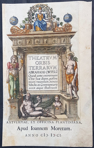
1601 Abraham Ortelius Antique Title Page from The Theatrum Orbis Terrarum Atlas
- Title : Theatrum Orbis Terrarum Abrahami Orteli Quod ante...Apud Joannem Moretum...Anno CICICCI (MDCI) (1601)
- Size: 17in x 10 1/2in (430mm x 270mm)
- Condition: (A) Good Condition
- Date : 1601
- Ref #: 32026
Description:
This hand coloured original copper plate engraved title page was published in the 1601 Latin edition of the first concise Atlas of the World Theatrum Orbis Terrarum. by Abraham Ortelius.
There were a total of 7300 copies of Theatrum published between 1570 - 1612 of which 200 were published in 1601. (Ref: Van Den Broecke; Tooley)
General Definitions:
Paper thickness and quality: - Heavy and stable
Paper color : - off white
Age of map color: - Early
Colors used: - Blue, pink, red, green, yellow
General color appearance: - Authentic
Paper size: - 17in x 10 1/2in (430mm x 270mm)
Plate size: - 13 3/4in x 9in (350mm x 230mm)
Margins: - Min 1/2in (12mm)
Imperfections:
Margins: - Age toning & light creasing
Plate area: - Light soiling
Verso: - Old tape residue neutralised
Background:
Theatrum Orbis Terrarum is considered to be the first true modern atlas. Written by Abraham Ortelius, strongly encouraged by Gillis Hooftman and originally printed on May 20, 1570, in Antwerp, it consisted of a collection of uniform map sheets and sustaining text bound to form a book for which copper printing plates were specifically engraved. The Ortelius atlas is sometimes referred to as the summary of sixteenth-century cartography. The publication of the Theatrum Orbis Terrarum (1570) is often considered as the official beginning of the Golden Age of Netherlandish cartography (approximately 1570s–1670s)
The atlas contained virtually no maps from the hand of Ortelius, but 53 bundled maps of other masters, with the source as indicated. Previously, only the pooling of disparate maps were released as custom on order. The Ortelius atlas, however, dropped the maps for this all in the same style and on the same size on copper plates, logically arranged by continent, region and State. He provided the maps in addition to a descriptive comment and referrals on the reverse. As such, this was the first time that the entirety of Western European knowledge of the world was brought together in one book.
In the bibliography, the section Catalogue Auctorum, not only were the 33 cartographers mentioned, whose work in the Theatrum was recorded (at that time not yet the habit), but also the total of 87 cartographers of the 16th century that Ortelius knew. This list grew in every Latin Edition, and included no less than 183 names in 1601. Among the sources are mentioned among other things the following: for the world map the World Map (1561) by Giacomo Gastaldi, the porto Avenue of the Atlantic coast (1562) by Diego Gutierrez, the world map (1569) of Gerardus Mercator, which have 8 maps derived from the Theatrum.
For the map of Europe, wall map (1554). of the Mercator map of Scandinavia (1539) by Olaus Magnus, map of Asia was derived from his own Asia-map from 1567, which in turn was inspired by that of Gastaldi (1559). Also for the Africa map he referred to Gastaldi.
This work by Ortelius, consisted of a collection of the best maps, refined by himself, combined into one map or split across multiple, and on the same size (folios of approximately 35 x 50 cm). The naming and location coordinates were not normalized.
After the initial publication of Theatrum Orbis Terrarum, Ortelius regularly revised and expanded the atlas, reissuing it in various formats until his death in 1598. From its original seventy maps and eighty-seven bibliographic references in the first edition (1570), the atlas grew through its thirty-one editions to encompass 183 references and 167 maps in 1612.
The online copy of the 1573 volume held by the State Library of New South Wales contains 70 numbered double-page sheets, tipped onto stubs at the centerfold, with 6 maps combined with descriptive letterpress on the recto of each first leaf. The legends of most maps name the author whose map Ortelius adapted. In the preface Ortelius credits Franciscus Hogenberg with engraving nearly all the maps.
The 1573 Additamentum to the atlas is notable for containing Humphrey Llwyds Cambriae Typus, the first map to show Wales on its own.
From the 1630s, the Blaeu family issued their work under a similar title, Theatrum orbis terrarum, sive, Atlas Novus.
All those editions had the same structure. They started with an allegorical title page, on which the five known continents, were presented by allegorical women, with Europe as the Queen. Then a command to Philip II, King of Spain and the low countries, and a poem by Adolphus Mekerchus (Adolf of Meetkercke). From 1579, the editions contain a portrait of Ortelius by Philip Galle, an introduction by Ortelius, in the Latin editions followed by a recommendation by Mercator. This is followed by the bibliography (Auctorum Catalog), an index (Index Tabularum), the cards with text on the back, starting from 1579 in the Latin editions followed by a register of place names in ancient times (Nomenclator), the treatise, the Mona Druidum insula of the Welsh scientist Humphrey Lhuyd (Humphrey Llwyd) over the Anglesey coat of arms, and finally the privilege and a colophon.
The moneyed middle class, which had much interest in knowledge and science, turned out to be very much interested in the convenient size and the pooling of knowledge. For buyers who were not strong in Latin, published at the end of 1572, in addition to three Latin, there were a Dutch, German and French 2nd Edition. This rapid success prompted the Ortelius Theatrum constantly continued to expand and improve. In 1573, he released 17 more additional maps under the title Additamentum Theatri Orbis Terrarum, which in these master works were published, bringing the total at 70 maps. By Ortelius death in 1598, there were twenty-five editions that appeared in seven different languages.
Please note all items auctioned are genuine, we do not sell reproductions. A Certificate of Authenticity (COA) can be issued on request.
1612 Abraham Ortelius Antique Maps of Loire Valley, River & Alliers River France
- Title : Regionis Biturigum Exactiss Descriptio per D. Ioannem Calamaeum. Limaniae Topographia Gabriele Symeoneo Auct. [The region of Berry exactly described by Jean Chameau. The topography around of Lyons by Gabriel Symeon]
- Size: 22in x 18 1/2in (560mm x 470mm)
- Condition: (A+) Fine Condition
- Date : 1612
- Ref #: 50228-1
Description:
These original copper-plate engraved antique maps, the first of the Loire River & Valley and the second of the Alliers River, was published by Abraham Ortelius in the 1612 Latin edition of Theatrum Orbis Terrarum.
These are two rare regional Abraham Ortelius maps on a single folio sheet. The Left Map, centered on Bourges, depicts the Loire Valley region from Gian to St. Sebastian in the south and from Le Blanc east as far as Nevers. Several important cities are noted, including Argenton, Neuers (Nevers), Bourges, Le Blang en Berry, Romarantin, Vierzon, Chasteau Neuf, and others. The right map follows the flow of the Alliers River from Randan to Gondole. Important cities, including Beauregard, Cleremont, among several others are noted. Each map features a decorative cartouche and details their respective regions in wonderful detail with attention to forests, cities, rivers and villages.
General Definitions:
Paper thickness and quality: - Heavy and stable
Paper color : - off white
Age of map color: -
Colors used: -
General color appearance: -
Paper size: - 22in x 18 1/2in (560mm x 470mm)
Plate size: - 19 1/2in x 12 1/2in (490mm x 310mm)
Margins: - Min 1in (25mm)
Imperfections:
Margins: - None
Plate area: - None
Verso: - None
Background:
The Loire Valley spanning 280 kilometres , is located in the middle stretch of the Loire River in central France, in both the administrative regions Pays de la Loire and Centre-Val de Loire. The area of the Loire Valley comprises about 800 square kilometres. It is referred to as the Cradle of the French and the Garden of France due to the abundance of vineyards, fruit orchards (such as cherries), and artichoke, and asparagus fields, which line the banks of the river. Notable for its historic towns, architecture, and wines, the valley has been inhabited since the Middle Palaeolithic period.
The Allier is a river in central France. It is a left tributary of the Loire. Its source is in the Massif Central, in the Lozère department, east of Mende. It flows generally north. It joins the Loire west of the city of Nevers.