Thomas Jefferys

1754 Thomas Jefferys Old, Antique Map of Europe - Large Poland
- Title : Europe T Jefferys Sc.
- Ref : 11-1804
- Size: 10in x 8in (255mm x 205mm)
- Date : 1754
- Condition: (A+) Fine Condition
Description:
This beautifully hand coloured original antique map of Europe by Thomas Jeffery's was published in 1754. (Ref: Tooley; M&B)
General Description:
Paper thickness and quality: - Heavy and stable
Paper color: - off white
Age of map color: - Early
Colors used: - Yellow, green, pink
General color appearance: - Good
Paper size: - 10in x 8in (255mm x 205mm)
Plate size: - 9 1/2in x 7 1/2in (240mm x 190mm)
Margins: - Min 1/4in (5mm)
Imperfections:
Margins: - None
Plate area: - Folds as issued
Verso: - None

1754 Thomas Jefferys Old, Antique Map of South America
- Title : South America
- Ref : 11-1964
- Size: 10in x 8in (255mm x 205mm)
- Date : 1754
- Condition: (A+) Fine Condition
Description:
This beautifully hand coloured original antique map of South America by Thomas Jeffery's was published in 1754. (Ref: Tooley; M&B)
General Description:
Paper thickness and quality: - Heavy and stable
Paper color: - off white
Age of map color: - Early
Colors used: - Yellow, green, pink
General color appearance: - Good
Paper size: - 10in x 8in (255mm x 205mm)
Plate size: - 9 1/2in x 7 1/2in (240mm x 190mm)
Margins: - Min 1/4in (5mm)
Imperfections:
Margins: - None
Plate area: - Folds as issued
Verso: - None

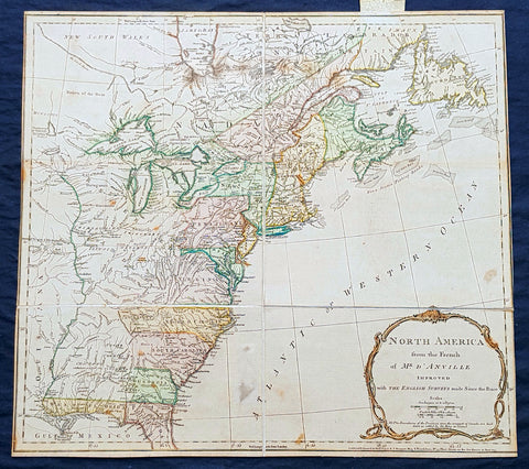
1755 Thomas Jefferys Antique English Edition Map The Colonial American Colonies
- Title : North America from the French of Mr. D Anville Improved with the Back Settlements of Virginia and Course of Ohio Illustrated with Geographical and Historical Remarks . . . Pub Thos. Jefferys..May 1755 . . .
- Size: 22in x 19in (500mm x 465mm)
- Condition: (A+) Fine Condition
- Date : 1755
- Ref #: 93343
Description:
A rare original 1st English edition of Thomas Jefferys map of the American Colonies, published in 1755 (dated) , after the French cartographer J B D Anville. This is one of the few maps published on North America from the British perspective at the time, as opposed to the French and German, published by D Anville and Homann.
This very important, scarce copper-plate engraved map was issued in the 1st 1755 edition of William Douglass A Summary Historical and Political of the first planting Progressive Improvements and Present State of the British Settlements in North America.
The map is in excellent condition on clean sturdy paper, folds as issued and original outline colouring. A small tear has been professionally repaired to the right side of the map, no loss.
The map is extremely detailed particularly in the Back Settlements with the locations of forts, Indian villages, tribal territory, and mines. Earl Granvilles Property is shown extending to the Mississippi River. Various treaty boundaries and charters are shown. Below the large, decorative title cartouche is a lengthy explanation describing the English Title to their Settlements on the Continent and at upper left is a notation concerning the French Incroachments.
General Definitions:
Paper thickness and quality: - Heavy and stable
Paper color : - off white
Age of map color: - Original
Colors used: - Yellow, green, blue, pink
General color appearance: - Authentic
Paper size: - 22in x 19in (500mm x 465mm)
Plate size: - 20 1/2in x 18 1/2in (510mm x 470mm)
Margins: - Min 1/2in (12mm)
Imperfections:
Margins: - Small repair to right margin into image, no loss
Plate area: - Folds as issued
Verso: - Light soiling
Background:
Jefferys and the Mapping of North America
The English had made manuscript maps, charts, and surveys since their earliest settlements in Virginia and New England, but few of these cartographic productions were ever printed. Most, like John Smiths New England (1616), appeared as part of larger geographical texts; there were only a very few separately published maps, such as those printed on broadsides by William Penn to promote his colony. The steady expansion of settlement and of the Atlantic trade led to a sufficient demand to warrant the publication of charts (notably in the English Pilot, The Fourth Book of 1689) and increasingly specialized chorographic maps. This expansion paralleled the general rise of English print culture after Parliament allowed censorship to lapse in 1695.
The real spurt in demand for maps of the American colonies came only after 1748 and the realization that the Treaty of Aix-la-Chapelles maintenance of the Anglo-French status quo in North America was only temporary. A more definitive resolution to the conflicting imperial claims was clearly looming and interest in the colonies climbed dramatically. At the same time, the existing maps of the American colonies lacked detail. The cartographic image of New England, for example, might be typified by the small-scale map of John Speed (1676) and the anonymous map in Cotton Mathers Magnalia Christi Americana (Mather 1702). There was a definite demand for large, highly detailed maps of all parts of the colonies.
Jefferys moved to take advantage of the increasing demand for maps of North America. Indeed, two of his maps both compiled by John Green are among the many highly significant maps of the colonies which first appeared in 1755. Once war was officially declared with France in 1756, Jefferys output of North American maps increased dramatically. Jefferys took a highly partisan line against the French and their territorial claims in North America. It is unnecessary to argue that he was being paid by the government to produce his cartographic and textual polemics; nor was he cynically meeting a demand created by the political tenor of the day. Rather, Jefferys sentiments were part of that political tenor. There were few, if any, dissenters who argued that the French policy of encircling and encroaching on the English colonies in North America did not pose a substantial threat.
First, Jefferys used existing French maps of North America. The critical geography of Guillaume de lIsle (1675-1726) and his successors Jean Nicolas Bellin (1693-1772), Jean Baptiste dAnville (1697-1782), and Philippe Buache (1700-1773) had coincided with the great amount of information generated by the French explorations along the interior waterways of North America to produce a number of large, detailed, and highly reputable maps of the continent. Jefferys sold many of these maps; he tipped advertisements announcing the availability at his shop of new maps from Paris into two works published in. More importantly, Jefferys also translated the French maps into English and published them anew. He did not pass off these copies as his own work. Instead, he prominently displayed the identities of their reputable authors, thereby stressing the maps accuracy and quality. An example of these maps is Jefferys North America From the French of Mr D Anville (London, May 1755), which was used as the frontispiece to the first (1755) London edition of Douglass (1749-52).
Jefferys did not restrict himself to stealing French maps. His second source of materials for North America were maps already printed either in the colonies, which did not enjoy copyright protection, or even other works printed in London. For example, in 1755, Jefferys directly pirated George Washingtons journal and map of his expedition to the Ohio in 1753.
Third, Jefferys followed the simple expedient of buying existing plates from other cartographers. Thomas Kitchin had in 1756, for example, pirated Lewis Evans General Map of the Middle British Colonies, in America (Philadelphia, 1755); Jefferys subsequently acquired this plate and reissued under his own name in 1758, against the opposition of Evans friend, Thomas Pownall. Again, Jefferys or perhaps more properly Sayer bought the plates of James Cooks surveys of Newfoundland, originally published at Cooks own cost and under his own imprint, and reprinted them in 1769 as part of a large collection of charts of the Canadian maritimes (Jefferys 1769) Those other charts reflect Jefferys other sources.
The fourth, and perhaps largest, set of source materials for Jefferys maps of North America were original manuscripts produced in the colonies and sent back to London. Some were sent back to London specifically to be engraved; Harley quotes a colonial advertisement in 1764 for a map that was explicitly to be engraved in London by Jefferys. Most of this category of maps, however, were published by Jefferys as a contractor to different government agencies. For example, the Board of Trade and Plantations in 1750 ordered the colonies to make maps of their territories (in order to get information to be used by John Mitchell for making his 1755 map of North America); Virginia directed Joshua Fry and Peter Jefferson to make such a map, which they completed in 1751 and sent back to London; ultimately, the board passed it on to Jefferys to be published and the map eventually appeared in print, probably in 1754. Harley also quotes the boards records with respect to Jefferys printing in 1760 of a map of Halifax harbour.
Jefferys fifth source of publishable maps and pamphlets was in-house: he employed geographers to compile new maps and books which he could then publish. We know today of the identity of only one of these employees, John Green. Green seems to have gone to work for Jefferys at about the same time as Jefferys moved to Charing Cross; we know that he produced three, or perhaps four, maps and three books which appeared under Jefferys imprint; he also planned and perhaps constructed other maps which did not appear in print. After Green committed suicide in 1757, Jefferys apparently employed a new geographer, who wrote the Natural and Civil History of the French Dominions (Jefferys 1760). Reviewers of this work did not think it as perfect as it might have been, which Harley has interpreted as indicating the lesser qualities of Greens replacement. It might be thought that Jefferys employment of critical geographers was part of the sort of ambitious, larger scheme in which Jefferys would later engage when he mapped several English counties. The similarity of the titles of the Fry and Jefferson map (1754) and of the Jefferys-Green map of New England (1755) is suggestive in this regard. Telling against such a supposition is the lack of critical concern displayed by Jefferys in the rest of his cartographic business. Green (1753) had concluded, for example, that the famed voyage by Admiral de Fonte to the northern Pacific was in fact completely fictitious, yet Jefferys continued to publish maps showing the spurious geography of North-western America derived from that fiction . Jefferys hiring of Green and his anonymous successor was clearly a business investment. The geographers wages constituted an extra cost, but in return Jefferys got a quality product that would only enhance his reputation. From the sorts of maps which we know Green to have worked on, but which were never completed, it does not seem that Jefferys sought to have new maps created so as to provide complete cartographic coverage across all the English territories in North America. Jefferys did not have a larger agenda, such as the advancement of geographical knowledge, other than the generation of profit.
Jean Baptiste Bourguignon d Anville was the successor to Guillaume De l Isle and maintained the rigorous standard for accuracy that De l Isle had established. D Anville was the last French mapmaker to establish an international reputation, superior to all his contemporaries, with respect shown by the English and other cartographers and publishers during an era when England & France were often at conflict with one another.
1775 Thomas Jefferys Antique Map North America & Colonial States, Pre Revolution
- Title : North America from the French of Mr. D Anville Improved with the English Surveys made Since the Peace NB. The Boundaries of the Provinces since the conquest of Canada are laid down as settled by the King in Council..London Printed for Robt. Sayer & J Bennett Map & Printseller, No 53 Fleet Street as the act directs 10 June 1775
- Size: 20 1/2in x 18 1/2in (510mm x 470mm)
- Condition: (A) Very Good Condition
- Date : 1775
- Ref #: 93045
Description:
This very important scarce original copper-plate engraved antique map of North America & the colonial States, is sectioned and laid down on linen as issued. The map by Thomas Jefferys - after JB D Anville, was engraved in 1775 - dated at the foot of the map - and was published by Robert Sayer and John Bennett, London.
Jean Baptiste Bourguignon d Anville was the successor to Guillaume De l Isle and maintained the rigorous standard for accuracy that De l Isle had established. D Anville was the last French mapmaker to establish an international reputation, superior to all his contemporaries, with respect shown by the English and other cartographers and publishers during an era when England & France were often at conflict with one another.
General Definitions:
Paper thickness and quality: - Heavy and stable
Paper color : - off white
Age of map color: - Original
Colors used: - Yellow, green, pink
General color appearance: - Authentic
Paper size: - 20 1/2in x 18 1/2in (510mm x 470mm)
Plate size: - 20 1/2in x 18 1/2in (510mm x 470mm)
Margins: - Min 0in (0mm)
Imperfections:
Margins: - Bottom right margin cropped to border
Plate area: - Spotting
Verso: - Linen strong and robust, spotting
Background:
This third state is the second edition of the map issued after the conclusion of the French and Indian War. The map shows the Colonies on the eve of the American Revolutionary War. A note in the title cartouche states that the Boundaries of the Provinces since the conquest of Canada are laid down as settled by the King in Council. This note appears in the second state as well. The map shows the various colonial claims running to the Mississippi, but the colourist has conservatively limited the borders to the Appalachian Mountains. The boundary between New England and Virginia as established by Charter in 1609 is shown, although the date is omitted.
The map is rich with details west of the Appalachians, including Indian Tribes, early French and English forts and other contemporary information on the eve of the revolution. Main is named, but [New] Hampshire takes up all of Vermont. Massachusetts Bay and Delaware Bay are named, as are East and West Florida. The region west of the Mississippi is dominated by Spanish Louisiana Territory, with the lands between the Mississippi and the Appalachians controlled by Indian Tribes. A nice wide margin example of this map of the Colonies, which was included in Jefferys American Atlas prior to and during the American Revolutionary War.
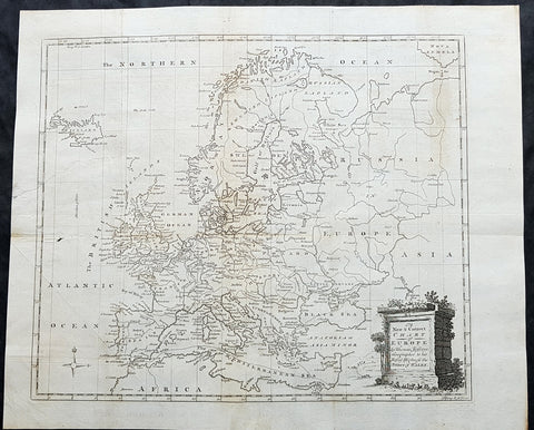
1782 Thomas Jefferys Large Original Antique Map of Europe
- Title : A New Chart of Europe by Thomas Jefferys Geographer to his Royal Highness the Prince of Wales
- Size: 17in x 14in (435mm x 355mm)
- Condition: (A) Very Good Condition
- Date : 1782
- Ref #: 92592
Description:
This large original antique copper-plate engraved map of Europe by the famous English cartographer Thomas Jefferys was published for the 1782 edition of George Henry Millars New Complete & Universal System of Geography
General Definitions:
Paper thickness and quality: - Heavy and stableThomas Kitchin
Paper color : - off white
Age of map color: -
Colors used: -
General color appearance: -
Paper size: - 17in x 14in (435mm x 355mm)
Plate size: - 15in x 13 1/2in (380mm x 345mm)
Margins: - Min 1/2in (10mm)
Imperfections:
Margins: - Small repair in right margin, no loss
Plate area: - 2in repair to right image, no loss
Verso: - Folds as issued
Background:
Millar, George Henry
Was responsible for the publication of The new and universal system of geography : being a complete history and description of the whole world, containing a particular, full, accurate, circumstantial and entertaining account, including the antient and present state of all the various countries of Europe, Asia, Africa, and America, as divided into empires, kingdoms, states, republics, and colonies.. Printed by Alexander Hogg ..., 1782.
This comprehensive world geography and history was liberally illustrated with decorative plates and maps covering Europe, Asia, Africa, and America with information about the history, geography, climate, people, flora and fauna etc. It also includes important eighteenth century voyages and discoveries including Captain Cook\\\\\\\'s second voyage. Although his third voyage is not included, there is a plate illustrating his death in Hawaii. Other illustrations include city views from around the world, native costumes and occupations, and indigenous flora and fauna. The foldout maps were engraved by Kitchin, Bowen, Conder and Lodge with plates by several renowned English engravers. There is a fine map of the American colonies and city plans for the harbors of New York, Charleston, Havana, and Boston. Complete with upwards of 120 capital engravings with 25 maps. Published by Alexander Hogg, London.