Robert Morden
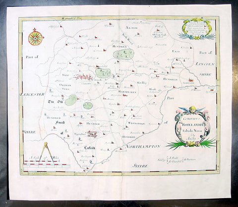
1695 Morden Antique Map The English County of Rutland
- Title : Comitatus Rotelandiae Tabula Nova & Aucta
- Ref #: 50145
- Size: 16in x 14in (405mm x 355mm)
- Date : 1695
- Condition: (A+) Fine Condition
Description:
This beautifully hand coloured original antique map of the English County of Rutland was engraved by Robert Morden for the 1695 edition of Camden's Britannia.
William Camden was an historian who first published his Britannia, a description and history of Britain, in 1586. Written in Latin, the book contained only a general map of the country but had a wide circulation and eventually in 1607 an edition (the sixth) was published with a series of maps with Latin text on the reverse.
Further editions in English were published in 1610 and 1637 but without text. (Many more editions were published up until 1806 with map contributions from Blaeu in 1617, John Bill 1626, Robert Morden 1695-1772 and John Cary 1789-1806)
In the 1610 & 1617 editions the maps were mostly engraved by William Kip and William Hole and were based on those of Christopher Saxton, but six were copied from John Norden.
The map of Pembroke is by George Owen and the general maps of England/Wales, Scotland and Ireland were probably taken from Mercator. Kip reduced the size of each map for Britannia from the originals published byChristopher Saxton in 1579. (Ref: Tooley; M&B)
General Description:
Paper thickness and quality: - Light and stable
Paper color: - off white
Age of map color: - Early
Colors used: - Red, yellow, blue, green, blue
General color appearance: - Authentic
Paper size: - 16in x 14in (405mm x 355mm)
Plate size: - 14 1/2in x 11 1/2in (370mm x 290mm)
Margins: - Min 1in (25m)
Imperfections:
Margins: - None
Plate area: - None
Verso: - None
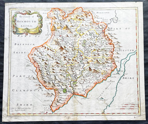
1695 Morden Antique Map The Welsh County of Monmouth
- Title : The County of Monmouth by Robert. Morden
- Ref #: 50155
- Size: 17 1/2in x 15in (445mm x 380mm)
- Date : 1695
- Condition: (A+) Fine Condition
Description:
This fine beautifully hand coloured original antique map of the Welsh county of Monmouth was engraved by Robert Morden & published by Abel Swale & John Churchil for the 1695 edition of Willam Camden's Britannia.
William Camden was an historian who first published his Britannia, a description and history of Britain, in 1586. Written in Latin, the book contained only a general map of the country but had a wide circulation and eventually in 1607 an edition (the sixth) was published with a series of maps with Latin text on the reverse.
Further editions in English were published in 1610 and 1637 but without text. (Many more editions were published up until 1806 with map contributions from Blaeu in 1617, John Bill 1626, Robert Morden 1695-1772 and John Cary 1789-1806)
In the 1610 & 1617 editions the maps were mostly engraved by William Kip and William Hole and were based on those of Christopher Saxton, but six were copied from John Norden.
The map of Pembroke is by George Owen and the general maps of England/Wales, Scotland and Ireland were probably taken from Mercator. Kip reduced the size of each map for Britannia from the originals published by Christopher Saxton in 1579. (Ref: Tooley; M&B)
General Description:
Paper thickness and quality: - Light and stable
Paper color: - off white
Age of map color: - Early
Colors used: - Red, yellow, blue, green, blue
General color appearance: - Authentic
Paper size: - 17 1/2in x 15in (445mm x 380mm)
Plate size: - 16 1/2in x 14in (420mm x 355mm)
Margins: - Min 1/2in (12mm)
Imperfections:
Margins: - 4 small repairs to bottom margin
Plate area: - None
Verso: - None
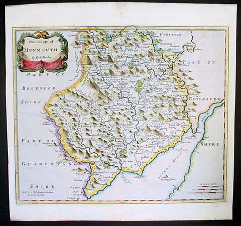
1695 Morden Antique Map The Welsh County of Monmouth
- Title : The County of Monmouth by Robert. Morden
- Ref #: 40869
- Size: 17 1/2in x 15in (445mm x 380mm)
- Date : 1695
- Condition: (A+) Fine Condition
Description:
This fine beautifully hand coloured original antique map of the Welsh county of Monmouth was engraved by Robert Morden & published by Abel Swale & John Churchil for the 1695 edition of Willam Camden's Britannia.
William Camden was an historian who first published his Britannia, a description and history of Britain, in 1586. Written in Latin, the book contained only a general map of the country but had a wide circulation and eventually in 1607 an edition (the sixth) was published with a series of maps with Latin text on the reverse.
Further editions in English were published in 1610 and 1637 but without text. (Many more editions were published up until 1806 with map contributions from Blaeu in 1617, John Bill 1626, Robert Morden 1695-1772 and John Cary 1789-1806)
In the 1610 & 1617 editions the maps were mostly engraved by William Kip and William Hole and were based on those of Christopher Saxton, but six were copied from John Norden.
The map of Pembroke is by George Owen and the general maps of England/Wales, Scotland and Ireland were probably taken from Mercator. Kip reduced the size of each map for Britannia from the originals published by Christopher Saxton in 1579. (Ref: Tooley; M&B)
General Description:
Paper thickness and quality: - Light and stable
Paper color: - off white
Age of map color: - Early
Colors used: - Red, yellow, blue, green, blue
General color appearance: - Authentic
Paper size: - 17 1/2in x 15in (445mm x 380mm)
Plate size: - 16 1/2in x 14in (420mm x 355mm)
Margins: - Min 1/2in (12mm)
Imperfections:
Margins: - 4 small repairs to bottom margin
Plate area: - None
Verso: - None
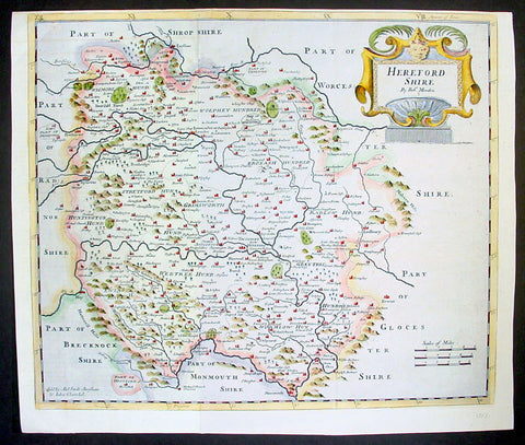
1695 Rob. Morden Antique Map English County of Hereford
- Title : Hereford Shire by Rob. Morden
- Ref #: 40868
- Size: 17in x 15in (430mm x 380mm)
- Date : 1695
- Condition: (A+) Fine Condition
Description:
This attractive original antique map of the English county of Hereford, by Robert Morden, was published in the 1695 edition of Camden's Britannia.
William Camden was an historian who first published his Britannia, a description and history of Britain, in 1586. Written in Latin, the book contained only a general map of the country but had a wide circulation and eventually in 1607 an edition (the sixth) was published with a series of maps with Latin text on the reverse.
Further editions in English were published in 1610 and 1637 but without text. (Many more editions were published up until 1806 with map contributions from Blaeu in 1617, John Bill 1626, Robert Morden 1695-1772 and John Cary 1789-1806)
In the 1610 & 1617 editions the maps were mostly engraved by William Kip and William Hole and were based on those of Christopher Saxton, but six were copied from John Norden.
The map of Pembroke is by George Owen and the general maps of England/Wales, Scotland and Ireland were probably taken from Mercator. Kip reduced the size of each map for Britannia from the originals published byChristopher Saxton in 1579. (Ref: Tooley; M&B)
General Description:
Paper thickness and quality: - Light and stable
Paper color: - off white
Age of map color: - Early
Colors used: - Red, yellow, blue, green
General color appearance: - Authentic, heavy
Paper size: - 17in x 15in (430mm x 380mm)
Plate size: - 17in x 15in (430mm x 380mm)
Margins: - Min 1/4in (4mm)
Imperfections:
Margins: - Top margin cropped close to border
Plate area: - None
Verso: - None
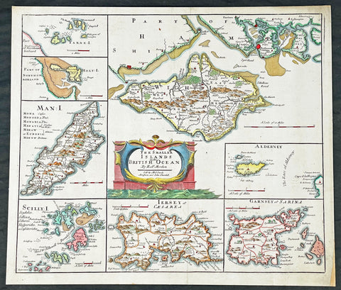
1695 Robert Morden Antique Map of the Islands of Great Britain & Ireland
-
Title : The Smaller Islands in the British Ocean by Rob Morden sold by Mel Swale Awnsham and John Churchill
- Ref #: 17012
-
Condition: (A) Very Good Condition
- Size: 17 1/2in x 15 1/2in (445mm x 395mm)
- Date : 1695
Description:
This fine original copper-plate engraved hand coloured antique map of the many Islands off the coast of Great Britain & Ireland by Robert Morden was published in the 1695 edition of Camdens Britannia.
General Definitions:
Paper thickness and quality: - Heavy and stable
Paper color : - off white
Age of map color: - Early
Colors used: - Red, yellow, green, blue
General color appearance: - Authentic
Paper size: - 17 1/2in x 15 1/2in (445mm x 395mm)
Plate size: - 17in x 141/2in (430mm x 370mm)
Margins: - Min 1/2in (12mm)
Imperfections:
Margins: - None
Plate area: - None
Verso: - Mounted to original board
Background:
These maps are the first county maps to show roads (based on Ogilby’s road maps) and show three scales representing great, middle and small miles as different scales were used in different parts of the country. Morden was employed to replace the outdated maps by Saxton, engraved by Kip and Hole. He based his maps on manuscript sources plus the surveys of Ogilby and Morgan, Seller, Palmer and the coastal charts of Captain Grenville Collins. One innovation was the showing of longitudes measured from the meridian of St. Paul's Cathedral given in the form of time in minutes at the top of the map in Roman numerals and at the bottom in degrees. This was done to clarify local times that were taken from the sun as there was no national standard time. Gibson said:' Where actual Surveys could be had, they were purchased at any rate; and for the rest, one of the best Copies extanct was sent to some of the most knowing Gentlemen in each County; with a request to supply the defects, rectified the positions, and correct the false spellings. And that nothing might be wanting to render them as complete and accurate as might be, this whole business was commited to Mr Robert Morden, a person of know abilities in these matters'..from the Preface of the Britannia.
Morden, Robert 1650 - 1703
Morden was an English bookseller, publisher, and maker of maps and globes. He was among the first successful commercial map makers.
Between about 1675 and his death in 1703, he was based under the sign of the Atlas at premises in Cornhill and New Cheapside, London. His cartographical output was large and varied. His best-known maps are those of South Wales, North Wales and the English Counties first published in a new edition of Camdens Britannia in 1695, and subsequently reissued in 1722, 1753 and 1772. These maps were based on new information from gentlemen of each county, and were newly engraved. Each had a decorated cartouche, and showed numerous place names. Morden also produced in 1701 a series of smaller county maps often known as Miniature Mordens.
In 1695 he published a map of Scotland. It is in parts (e.g. Skye and the Western Isles) essentially a copy of the 1654 map done by Robert Gordon of Straloch, published by Joan Blaeu; other parts show evidence of more accurate cartography.
His (fourth edition) of Geography Rectified: or a Description of the World from 1700 dedicated to a Thomas Goddard, is a comprehensive work from many aspects. Its more than 700 pages, including a long pedagogic preface, no less than 78 maps from Europe including the British Isles, Asia, Africa, America and a two circular maps of the world, representing planet Earth seen from exactly opposite sides - the known world as of its time. (Australia and Antarctica were not yet known in Europe by then.) It further contains explanations of many general geographical concepts such as Latitude and Longitude and more. It also contains several comparisons of commodities, customs, history, governments, coins and weights (etc) with those in London. Its index is extensive. A copy has been stored at British Museum for more than a century.
He published a new map of the Tamil homeland, Coylot Wanees Country, in 17th-century Ceylon island.
He is also known for several very rare early maps of the British colonies in North America, which are now among the earliest and most sought after maps for collectors of old American maps. He also produced a series of miniature maps of the world, which appeared in both playing card format and in a series of atlases, including his Atlas Terrestris and Geography Anatomizd, beginning in 1687.
Please note all items auctioned are genuine, we do not sell reproductions. A Certificate of Authenticity (COA) can be issued on request.
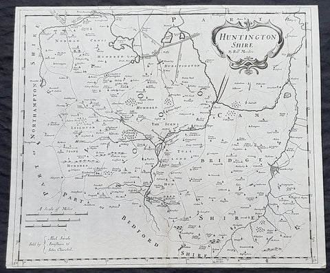
1722 Robert Morden Antique Map of Huntington in County of Cambridgeshire England
- Title : Huntington Shire by Robt. Morden...Sold by Abel Swale Awsham & John Churchill
- Size: 17 1/4in x 14 1/2in (435mm x 370mm)
- Condition: (A+) Fine Condition
- Date : 1722
- Ref #: 92680
Description:
This fine original copper-plate engraved antique map of the English region of Huntingdonshire, in the county of Cambridgeshire by Robert Morden was published in the 1722 edition of Camdens Britannia.
General Definitions:
Paper thickness and quality: - Heavy and stable
Paper color : - off white
Age of map color: -
Colors used: -
General color appearance: -
Paper size: - 17 1/4in x 14 1/2in (435mm x 370mm)
Plate size: - 17 1/4in x 14 1/2in (435mm x 370mm)
Margins: - Min 1/2in (6mm)
Imperfections:
Margins: - None
Plate area: - None
Verso: - None
Background:
William Camden 1551 – 1623 was an English antiquarian, historian, topographer, and herald, best known as author of Britannia, the first chorographical survey of the islands of Great Britain and Ireland, and the Annales, the first detailed historical account of the reign of Elizabeth I of England.
In 1577, with the encouragement of Abraham Ortelius, Camden began his great work Britannia, a topographical and historical survey of all of Great Britain and Ireland. His stated intention was to restore antiquity to Britaine, and Britain to his antiquity. The first edition, written in Latin, was published in 1586. It proved very popular, and ran through five further editions, of 1587, 1590, 1594, 1600 and 1607, each greatly enlarged from its predecessor in both textual content and illustrations. The 1607 edition included for the first time a full set of English county maps, based on the surveys of Christopher Saxton and John Norden, and engraved by William Kip and William Hole (who also engraved the fine frontispiece). The first English language edition, translated by Philemon Holland, appeared in 1610, again with some additional content supplied by Camden.
Britannia is a county-by-county description of Great Britain and Ireland. It is a work of chorography: a study that relates landscape, geography, antiquarianism, and history. Rather than write a history, Camden wanted to describe in detail the Great Britain of the present, and to show how the traces of the past could be discerned in the existing landscape. By this method, he produced the first coherent picture of Roman Britain.
He continued to collect materials and to revise and expand Britannia throughout his life. He drew on the published and unpublished work of John Leland and William Lambarde, among others, and received the assistance of a large network of correspondents with similar interests. He also travelled throughout Great Britain to view documents, sites, and artefacts for himself: he is known to have visited East Anglia in 1578, Yorkshire and Lancashire in 1582, Devon in 1589, Wales in 1590, Salisbury, Wells and Oxford in 1596, and Carlisle and Hadrians Wall in 1599. His fieldwork and firsthand research set new standards for the time. He even learned Welsh and Old English for the task: his tutor in Old English was Laurence Nowell.
In 1593 Camden became headmaster of Westminster School. He held the post for four years, but left when he was appointed Clarenceux King of Arms. By this time, largely because of the Britannias reputation, he was a well-known and revered figure, and the appointment was meant to free him from the labour of teaching and to facilitate his research. The College of Arms at that time was not only a centre of genealogical and heraldic study, but also a centre of antiquarian study. The appointment, however, roused the jealousy of Ralph Brooke, York Herald, who, in retaliation, published an attack on Britannia, charging Camden with inaccuracy and plagiarism. Camden successfully defended himself against the charges in subsequent editions of the work.
Britannia was recognised as an important work of Renaissance scholarship, not only in England, but across the European Republic of Letters. Camden considered having the 1586 Britannia printed in the Low Countries, and although that did not happen, the third edition of 1590, in addition to its London printing, was also published the same year in Frankfurt, and reprinted there in 1616. In 1612 parts were condemned by the Spanish Inquisition. An abridgement was published in Amsterdam in 1617 and reprinted in 1639; and versions of the text were also included in Joan Blaeus Theatrum Orbis Terrarum (published in Amsterdam in 1645) and in Jan Janssoniuss Novus Atlas (again published in Amsterdam, in 1646)
1722 Robert Morden Antique Map of Huntington in County of Cambridgeshire England
- Title : Huntington Shire by Robt. Morden...Sold by Abel Swale Awsham & John Churchill
- Size: 17 1/4in x 14 1/2in (435mm x 370mm)
- Condition: (A+) Fine Condition
- Date : 1722
- Ref #: 50149
Description:
This fine original copper-plate engraved antique map of the English region of Huntingdonshire, in the county of Cambridgeshire by Robert Morden was published in the 1722 edition of Camdens Britannia.
General Definitions:
Paper thickness and quality: - Heavy and stable
Paper color : - off white
Age of map color: -
Colors used: -
General color appearance: -
Paper size: - 17 1/4in x 14 1/2in (435mm x 370mm)
Plate size: - 17 1/4in x 14 1/2in (435mm x 370mm)
Margins: - Min 1/2in (6mm)
Imperfections:
Margins: - Light age toning
Plate area: - Light age toning
Verso: - Light age toning
Background:
William Camden 1551 – 1623 was an English antiquarian, historian, topographer, and herald, best known as author of Britannia, the first chorographical survey of the islands of Great Britain and Ireland, and the Annales, the first detailed historical account of the reign of Elizabeth I of England.
In 1577, with the encouragement of Abraham Ortelius, Camden began his great work Britannia, a topographical and historical survey of all of Great Britain and Ireland. His stated intention was to restore antiquity to Britaine, and Britain to his antiquity. The first edition, written in Latin, was published in 1586. It proved very popular, and ran through five further editions, of 1587, 1590, 1594, 1600 and 1607, each greatly enlarged from its predecessor in both textual content and illustrations. The 1607 edition included for the first time a full set of English county maps, based on the surveys of Christopher Saxton and John Norden, and engraved by William Kip and William Hole (who also engraved the fine frontispiece). The first English language edition, translated by Philemon Holland, appeared in 1610, again with some additional content supplied by Camden.
Britannia is a county-by-county description of Great Britain and Ireland. It is a work of chorography: a study that relates landscape, geography, antiquarianism, and history. Rather than write a history, Camden wanted to describe in detail the Great Britain of the present, and to show how the traces of the past could be discerned in the existing landscape. By this method, he produced the first coherent picture of Roman Britain.
He continued to collect materials and to revise and expand Britannia throughout his life. He drew on the published and unpublished work of John Leland and William Lambarde, among others, and received the assistance of a large network of correspondents with similar interests. He also travelled throughout Great Britain to view documents, sites, and artefacts for himself: he is known to have visited East Anglia in 1578, Yorkshire and Lancashire in 1582, Devon in 1589, Wales in 1590, Salisbury, Wells and Oxford in 1596, and Carlisle and Hadrians Wall in 1599. His fieldwork and firsthand research set new standards for the time. He even learned Welsh and Old English for the task: his tutor in Old English was Laurence Nowell.
In 1593 Camden became headmaster of Westminster School. He held the post for four years, but left when he was appointed Clarenceux King of Arms. By this time, largely because of the Britannias reputation, he was a well-known and revered figure, and the appointment was meant to free him from the labour of teaching and to facilitate his research. The College of Arms at that time was not only a centre of genealogical and heraldic study, but also a centre of antiquarian study. The appointment, however, roused the jealousy of Ralph Brooke, York Herald, who, in retaliation, published an attack on Britannia, charging Camden with inaccuracy and plagiarism. Camden successfully defended himself against the charges in subsequent editions of the work.
Britannia was recognised as an important work of Renaissance scholarship, not only in England, but across the European Republic of Letters. Camden considered having the 1586 Britannia printed in the Low Countries, and although that did not happen, the third edition of 1590, in addition to its London printing, was also published the same year in Frankfurt, and reprinted there in 1616. In 1612 parts were condemned by the Spanish Inquisition. An abridgement was published in Amsterdam in 1617 and reprinted in 1639; and versions of the text were also included in Joan Blaeus Theatrum Orbis Terrarum (published in Amsterdam in 1645) and in Jan Janssoniuss Novus Atlas (again published in Amsterdam, in 1646)
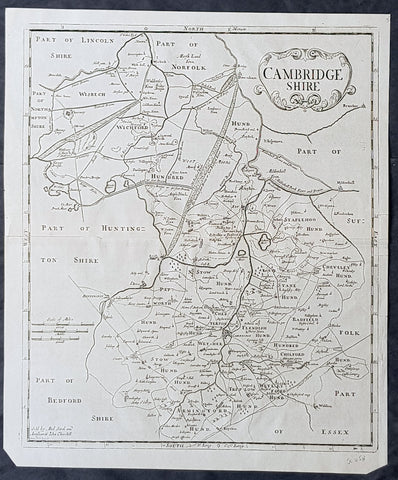
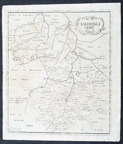
1722 Robert Morden Antique Map of the English County of Cambridgeshire
- Title : Cambridgeshire...Sold by Abel Swal and Awsham& John Churchill Sutton Nicholls sculp.
- Size: 16 1/4in x 15in (460mm x 380mm)
- Condition: (A+) Fine Condition
- Date : 1722
- Ref #: 40181
Description:
This fine original copper-plate engraved antique map of the English county of Cambridgeshire by Robert Morden was published in the 1722 edition of Camdens Britannia.
General Definitions:
Paper thickness and quality: - Heavy and stable
Paper color : - off white
Age of map color: -
Colors used: -
General color appearance: -
Paper size: - 16 1/4in x 15in (460mm x 380mm)
Plate size: - 15 1/2in x 14 1/2in (450mm x 370mm)
Margins: - Min 1/2in (12mm)
Imperfections:
Margins: - None
Plate area: - None
Verso: - None
Background:
William Camden 1551 – 1623 was an English antiquarian, historian, topographer, and herald, best known as author of Britannia, the first chorographical survey of the islands of Great Britain and Ireland, and the Annales, the first detailed historical account of the reign of Elizabeth I of England.
In 1577, with the encouragement of Abraham Ortelius, Camden began his great work Britannia, a topographical and historical survey of all of Great Britain and Ireland. His stated intention was to restore antiquity to Britaine, and Britain to his antiquity. The first edition, written in Latin, was published in 1586. It proved very popular, and ran through five further editions, of 1587, 1590, 1594, 1600 and 1607, each greatly enlarged from its predecessor in both textual content and illustrations. The 1607 edition included for the first time a full set of English county maps, based on the surveys of Christopher Saxton and John Norden, and engraved by William Kip and William Hole (who also engraved the fine frontispiece). The first English language edition, translated by Philemon Holland, appeared in 1610, again with some additional content supplied by Camden.
Britannia is a county-by-county description of Great Britain and Ireland. It is a work of chorography: a study that relates landscape, geography, antiquarianism, and history. Rather than write a history, Camden wanted to describe in detail the Great Britain of the present, and to show how the traces of the past could be discerned in the existing landscape. By this method, he produced the first coherent picture of Roman Britain.
He continued to collect materials and to revise and expand Britannia throughout his life. He drew on the published and unpublished work of John Leland and William Lambarde, among others, and received the assistance of a large network of correspondents with similar interests. He also travelled throughout Great Britain to view documents, sites, and artefacts for himself: he is known to have visited East Anglia in 1578, Yorkshire and Lancashire in 1582, Devon in 1589, Wales in 1590, Salisbury, Wells and Oxford in 1596, and Carlisle and Hadrians Wall in 1599. His fieldwork and firsthand research set new standards for the time. He even learned Welsh and Old English for the task: his tutor in Old English was Laurence Nowell.
In 1593 Camden became headmaster of Westminster School. He held the post for four years, but left when he was appointed Clarenceux King of Arms. By this time, largely because of the Britannias reputation, he was a well-known and revered figure, and the appointment was meant to free him from the labour of teaching and to facilitate his research. The College of Arms at that time was not only a centre of genealogical and heraldic study, but also a centre of antiquarian study. The appointment, however, roused the jealousy of Ralph Brooke, York Herald, who, in retaliation, published an attack on Britannia, charging Camden with inaccuracy and plagiarism. Camden successfully defended himself against the charges in subsequent editions of the work.
Britannia was recognised as an important work of Renaissance scholarship, not only in England, but across the European Republic of Letters. Camden considered having the 1586 Britannia printed in the Low Countries, and although that did not happen, the third edition of 1590, in addition to its London printing, was also published the same year in Frankfurt, and reprinted there in 1616. In 1612 parts were condemned by the Spanish Inquisition. An abridgement was published in Amsterdam in 1617 and reprinted in 1639; and versions of the text were also included in Joan Blaeus Theatrum Orbis Terrarum (published in Amsterdam in 1645) and in Jan Janssoniuss Novus Atlas (again published in Amsterdam, in 1646)
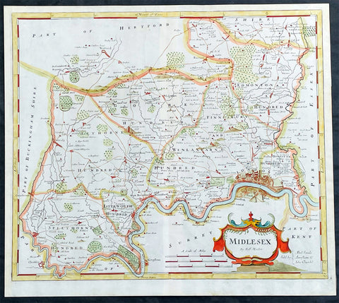
1722 Robert Morden Antique Map of The English County of Middlesex, London
- Title : Midlesex
- Date : 1722
- Size: 17 1/2in x 15 1/2in (445mm x 395mm)
- Condition: (A+) Fine Condition
- Ref: 35603
Description:
This original hand coloured copper-plate engraved antique map of the county of Middlesex and London by Robert Morden was published in the 1722 edition of Camdens Britannia.
General Definitions:
Paper thickness and quality: - Heavy and stable
Paper color : - off white
Age of map color: - Original
Colors used: - Pink, blue, green, yellow
General color appearance: - Authentic
Paper size: - 17 1/2in x 15 1/2in (445mm x 395mm)
Plate size: - 17 1/2in x 15 1/2in (445mm x 395mm)
Margins: - Min 1/2in (12mm)
Imperfections:
Margins: - None
Plate area: - None
Verso: - None
Background:
These maps are the first county maps to show roads (based on Ogilby’s road maps) and show three scales representing great, middle and small miles as different scales were used in different parts of the country. Morden was employed to replace the outdated maps by Saxton, engraved by Kip and Hole. He based his maps on manuscript sources plus the surveys of Ogilby and Morgan, Seller, Palmer and the coastal charts of Captain Grenville Collins. One innovation was the showing of longitudes measured from the meridian of St. Paul's Cathedral given in the form of time in minutes at the top of the map in Roman numerals and at the bottom in degrees. This was done to clarify local times that were taken from the sun as there was no national standard time. Gibson said:' Where actual Surveys could be had, they were purchased at any rate; and for the rest, one of the best Copies extanct was sent to some of the most knowing Gentlemen in each County; with a request to supply the defects, rectified the positions, and correct the false spellings. And that nothing might be wanting to render them as complete and accurate as might be, this whole business was commited to Mr Robert Morden, a person of know abilities in these matters'..from the Preface of the Britannia.
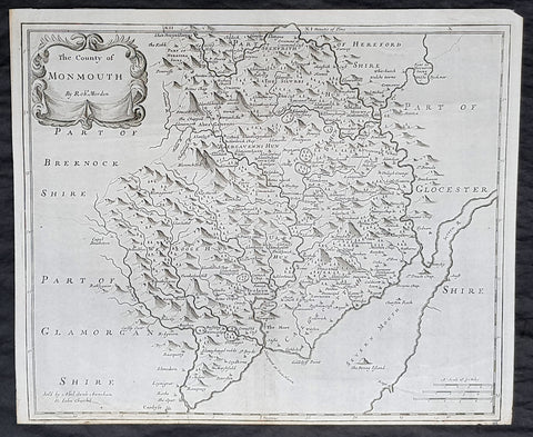
1722 Robert Morden Antique Map of the Welsh County of Monmouth
- Title : The county of Monmouth by Robt. Morden...Sold by Abel Swale Awsham & John Churchill
- Size: 17 1/4in x 14 1/2in (435mm x 370mm)
- Condition: (A+) Fine Condition
- Date : 1722
- Ref #: 70317
Description:
This fine original copper-plate engraved antique map of the Welsh county of Monmouth by Robert Morden was published in the 1722 edition of Camdens Britannia.
General Definitions:
Paper thickness and quality: - Heavy and stable
Paper color : - off white
Age of map color: -
Colors used: -
General color appearance: -
Paper size: - 17 1/4in x 14 1/2in (435mm x 370mm)
Plate size: - 17 1/4in x 14 1/2in (435mm x 370mm)
Margins: - Min 1/2in (6mm)
Imperfections:
Margins: - None
Plate area: - None
Verso: - None
Background:
William Camden 1551 – 1623 was an English antiquarian, historian, topographer, and herald, best known as author of Britannia, the first chorographical survey of the islands of Great Britain and Ireland, and the Annales, the first detailed historical account of the reign of Elizabeth I of England.
In 1577, with the encouragement of Abraham Ortelius, Camden began his great work Britannia, a topographical and historical survey of all of Great Britain and Ireland. His stated intention was to restore antiquity to Britaine, and Britain to his antiquity. The first edition, written in Latin, was published in 1586. It proved very popular, and ran through five further editions, of 1587, 1590, 1594, 1600 and 1607, each greatly enlarged from its predecessor in both textual content and illustrations. The 1607 edition included for the first time a full set of English county maps, based on the surveys of Christopher Saxton and John Norden, and engraved by William Kip and William Hole (who also engraved the fine frontispiece). The first English language edition, translated by Philemon Holland, appeared in 1610, again with some additional content supplied by Camden.
Britannia is a county-by-county description of Great Britain and Ireland. It is a work of chorography: a study that relates landscape, geography, antiquarianism, and history. Rather than write a history, Camden wanted to describe in detail the Great Britain of the present, and to show how the traces of the past could be discerned in the existing landscape. By this method, he produced the first coherent picture of Roman Britain.
He continued to collect materials and to revise and expand Britannia throughout his life. He drew on the published and unpublished work of John Leland and William Lambarde, among others, and received the assistance of a large network of correspondents with similar interests. He also travelled throughout Great Britain to view documents, sites, and artefacts for himself: he is known to have visited East Anglia in 1578, Yorkshire and Lancashire in 1582, Devon in 1589, Wales in 1590, Salisbury, Wells and Oxford in 1596, and Carlisle and Hadrians Wall in 1599. His fieldwork and firsthand research set new standards for the time. He even learned Welsh and Old English for the task: his tutor in Old English was Laurence Nowell.
In 1593 Camden became headmaster of Westminster School. He held the post for four years, but left when he was appointed Clarenceux King of Arms. By this time, largely because of the Britannias reputation, he was a well-known and revered figure, and the appointment was meant to free him from the labour of teaching and to facilitate his research. The College of Arms at that time was not only a centre of genealogical and heraldic study, but also a centre of antiquarian study. The appointment, however, roused the jealousy of Ralph Brooke, York Herald, who, in retaliation, published an attack on Britannia, charging Camden with inaccuracy and plagiarism. Camden successfully defended himself against the charges in subsequent editions of the work.
Britannia was recognised as an important work of Renaissance scholarship, not only in England, but across the European Republic of Letters. Camden considered having the 1586 Britannia printed in the Low Countries, and although that did not happen, the third edition of 1590, in addition to its London printing, was also published the same year in Frankfurt, and reprinted there in 1616. In 1612 parts were condemned by the Spanish Inquisition. An abridgement was published in Amsterdam in 1617 and reprinted in 1639; and versions of the text were also included in Joan Blaeus Theatrum Orbis Terrarum (published in Amsterdam in 1645) and in Jan Janssoniuss Novus Atlas (again published in Amsterdam, in 1646)