Jules Sébastien César Dumont d Urville
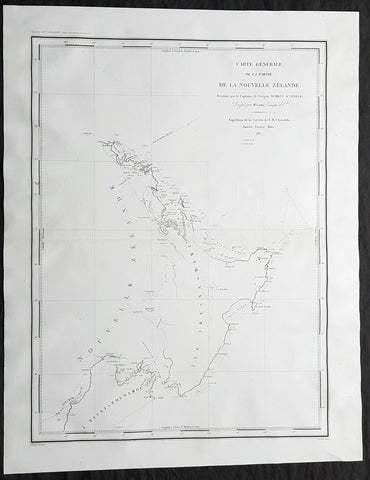
1827 Dumont D Urville Large Antique Early Map of New Zealand
- Title : Carte Generale de la Partie De La Nouvelle Zelande Reconnue par le Capitaine de Fregate Dumont D Urville Dressee par Mr Loottin Enseigue de v au Expedition de la Corvette de S M L Astrolobe Janvier, Fevrier, Mars, 1827
- Size: 26in x 20in (660mm x 510mm)
- Condition: (A+) Fine Condition
- Date : 1827
- Ref #: 42011
Description:
This magnificent large original & scarce copper-plate engraved antique map of the North Island & part of the South Island of New Zealand by Dumont D Urville and Lieutenant Victor Lottin, aboard the ship The Astrolabe during the first D Urville voyage to the South Seas 1826 - 1829, was engraved by Alphonse Chassant, 1808-1907 and published in the 1836 edition of Dumont d Urvilles Voyage de la corvette L Astrolabe: exécuté par ordre du roi, pendant les années 1826-1827-1828-1829......
Fantastic & rare map by D Urville & Lottin with surveys made of the north, south east coasts of New Zealands North Island & the north west part of the South Island, between January and March 1827.
General Definitions:
Paper thickness and quality: - Heavy and stable
Paper color : - off white
Age of map color: -
Colors used: -
General color appearance: -
Paper size: - 26in x 20in (660mm x 510mm)
Plate size: - 26in x 20in (660mm x 510mm)
Margins: - Min 2in (50mm)
Imperfections:
Margins: - None
Plate area: - None
Verso: - None
Background:
On 25 April 1826, Dumont d Urville, with the rank of commander, sailed from Toulon as chief of the ship formerly named the Coquille, renamed Astrolabe, on a voyage of exploration and scientific inquiry which lasted till 24 March 1829. On 10 January 1827 the Astrolabe came in sight of the north-west coast of the South Island of New Zealand. On 14 January the ship passed the entrance to the modern Golden Bay, which had been visited by Abel Tasman. The ship anchored off the west side of Tasman Bay. This bay had not been investigated at close quarters previously. In the following days d Urville established that it was a great deal bigger than Cooks mapping indicated, and his officers surveyed and charted it. Adele Island, Pepin Island, and Croisilles Harbour are modern names derived from those given by d Urville. On 23 January d Urville made for a channel which he had noticed at a distance some time before, and which seemed to him to communicate between Tasman Bay and Cooks Admiralty Bay. This was the channel culminating in French Pass and dividing D Urville Island from the mainland. Victor Lottin and Gressien, two of d Urville\'s officers, on the same day saw the pass at close quarters from two of the ships boats. On 25 January d Urville went through the pass into Admiralty Bay in a ship\'s boat. On 28 January the Astrolabe made the hazardous passage into Admiralty Bay. The investigation of Tasman Bay and the discovery of French Pass and the insularity of D Urville Island were significant contributions by d Urville to the discovery of New Zealands coastline.
From Cook Strait d Urville went north along the coast to Whangarei Harbour, which was surveyed and charted on 21–23 February 1827. The Astrolabe then doubled back to Hauraki Gulf, passing between the main coastal islands on the west side of the gulf on 25–27 February. The Astrolabe had been preceded in this passage by the Prince Regent in 1820, but the surveys and charts made under d Urville\'s command were notable contributions to the cartography of New Zealands coast. Lottin crossed the isthmus on 26 February and made a survey of Manukau Harbour, discovered in 1820 by Samuel Marsden. From Hauraki Gulf d Urville proceeded to North Cape and then to the Bay of Islands, leaving New Zealand in March 1827.
Lottin, Victor Charles 1795 - 1858. Lottin was a French frigate captain and geographer who took part in the voyage made around the world by the Astrolabe, under the command of Dumont-d Urville. He served as a lieutenant on the research expedition to Iceland and Greenland. During these two excursions, Lottin drew several maps and gathered a large quantity of objects of natural history, and made mention of the aurora borealis, inserted in the Annales Maritimes (1839). He was a member of the Academy of Sciences, Section of Geography and Navigation (elected in 1852) and a Knight of the Legion of Honour.
He died at Versailles on 18 February 1858.
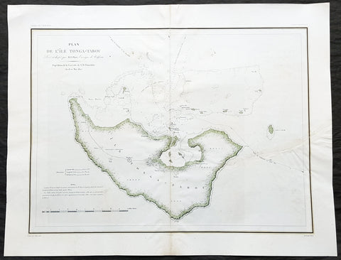
1827 Dumont D Urville Large Antique Map The Island of Tongatapu Tonga, Astrolabe
- Title : Plan de L Isle Tonga-Tabou Leve et dresse par M.E. Paris, Enseigne de Vaisseau Expedition de la Corvette de S M L Astrolobe Avril et Mai, 1827
- Size: 26 1/2in x 20 1/2in (675mm x 520mm)
- Condition: (A) Very Good Condition
- Date : 1827
- Ref #: 32157
Description:
This magnificent large original & scarce lithograph antique map of the largest island in the Tonga Isalnd group, Tongatapu, by Dumont D Urville and Lieutenant Victor Lottin, aboard the ship The Astrolabe during the first D Urville voyage to the South Seas 1826 - 1829, was engraved by Alphonse Chassant, 1808-1907 and published in the 1836 edition of Dumont d Urvilles Voyage de la corvette L Astrolabe: exécuté par ordre du roi, pendant les années 1826-1827-1828-1829......
General Definitions:
Paper thickness and quality: - Heavy and stable
Paper color : - off white
Age of map color: - Original
Colors used: - Green, yellow
General color appearance: - Authentic
Paper size: - 26 1/2in x 20 1/2in (675mm x 520mm)
Plate size: - 26 1/2in x 20 1/2in (675mm x 520mm)
Margins: - Min 2in (50mm)
Imperfections:
Margins: - None
Plate area: - Centerfold re-joined, left side of image re-joined, no loss
Verso: - Repairs as noted above
Background:
This map illustrates the route taken by the ship The Astrolabe and Dumont D Urville & crew after leaving New Zealand in March 1827. D Urville extensively surveyed Tongatapu and nearby island between April & May 1827.
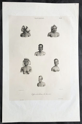
1836 D Urville & Sainson Antique Print Men & Women of Vanikoro Isle, Solomon Is.
- Title : Vanikoro. Coiffures des habitans des deux sexes
- Size: 20 1/2in x 13 1/2in (520mm x 345mm)
- Condition: (A+) Fine Good Condition
- Date : 1836
- Ref #: 31751
Description:
This large, magnificent, original antique lithograph print of hair styles of the men & woman of the island of Vanikoro, part of the Solomon Islands in the south Pacific (and last resting place of the ill fated La Perouse expedition), by Louis Auguste de Sainson, artist on the Astrolabe, during the first of Dumont D Urvilles voyages to the South Seas, between 1826 - 1829, was engraved by Antoine Maurin 1793 - 1860 and published in the 1836 1st edition of Dumont d UrvillesVoyage de la corvette L Astrolabe: exécuté par ordre du roi, pendant les années 1826-1827-1828-1829......
Louis Auguste de Sainson, (1800-1848). Sainson was a French draftsman & artist who specialized in natural history and geography. He accompanied the expedition of the corvette L Astrolabe as a naturalist directed by Jules Dumont d\'Urville between 1826-1829.
He began his naval career in a secretarial position at the French Atlantic port of Rochefort, working there from 1825 till 1826. He then volunteered to join the Astrolabe as a draughtsman, after being recommended to the expedition by Quoy, one of the naturalists on the expedition, joining the ship at Toulon on 7 February 1826.
He was responsible for the bulk of the drawings produced during the expedition, with over 500 in three years. Many of his drawings paintings and prints now reside in Australian, New Zealand & French museums.
General Definitions:
Paper thickness and quality: - Heavy and stable
Paper color : - off white
Age of map color: -
Colors used: -
General color appearance: -
Paper size: - 20 1/2in x 13 1/2in (520mm x 345mm)
Plate size: - 20 1/2in x 13 1/2in (520mm x 345mm)
Margins: - Min 2in (50mm)
Imperfections:
Margins: - None
Plate area: - None
Verso: - None
Background:
Vanikoro (sometimes wrongly named Vanikolo) is an island in the Santa Cruz group, located 118 kilometres to the Southeast of the main Santa Cruz group. It is part of the Temotu Province of the Solomon Islands.
The first sighting of Vanikoro by Europeans was in September 1595, by the second Spanish expedition of Álvaro de Mendaña. It was sighted by Lorenzo Barreto, while in command of one of the smaller vessels on a voyage around the then Santa Cruz, which is today\'s Nendo Island.
The French explorer Jean-François de La Pérouse was stranded on Vanikoro after both his vessels, La Boussole and the Astrolabe, struck the then unknown reefs of the island in 1788. It is reported that some of the men were killed by the local inhabitants, while the surviving sailors built a smaller vessel and left the island, but were never seen again. Those that remained on the island died before search parties of Dumont D Urville arrived in 1826.
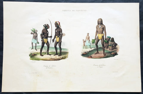
1836 D Urville & Sainson Antique Print of Vanikoro & Tikopia Islands, Solomon Isands
- Title : Tikopia et Vanikoro: Costumes des habitans de Vanikoro: Costumes des habitans de Tikopia
- Size: 19 1/2in x 13in (495mm x 330mm)
- Condition: (A+) Fine Good Condition
- Date : 1836
- Ref #: 31735
Description:
This large, magnificent, original antique lithograph print of the peoples of the island of Vanikoro & Tikopia, part of the Solomon Islands in the south Pacific (and last resting place of the ill fated La Perouse expedition), by Louis Auguste de Sainson, artist on the Astrolabe, during the first of Dumont D Urvilles voyages to the South Seas, between 1826 - 1829, was engraved by Antoine Maurin 1793 - 1860 and published in the 1836 1st edition of Dumont d Urvilles Voyage de la corvette L Astrolabe: exécuté par ordre du roi, pendant les années 1826-1827-1828-1829......
Louis Auguste de Sainson, (1800-1848). Sainson was a French draftsman & artist who specialized in natural history and geography. He accompanied the expedition of the corvette L Astrolabe as a naturalist directed by Jules Dumont d\'Urville between 1826-1829.
He began his naval career in a secretarial position at the French Atlantic port of Rochefort, working there from 1825 till 1826. He then volunteered to join the Astrolabe as a draughtsman, after being recommended to the expedition by Quoy, one of the naturalists on the expedition, joining the ship at Toulon on 7 February 1826.
He was responsible for the bulk of the drawings produced during the expedition, with over 500 in three years. Many of his drawings paintings and prints now reside in Australian, New Zealand & French museums.
General Definitions:
Paper thickness and quality: - Heavy and stable
Paper color : - off white
Age of map color: - Early
Colors used: - Yellow, pink, green, blue
General color appearance: - Authentic
Paper size: - 19 1/2in x 13in (495mm x 330mm)
Plate size: - 19 1/2in x 13in (495mm x 330mm)
Margins: - Min 1in (25mm)
Imperfections:
Margins: - Light soiling in margins
Plate area: - None
Verso: - None
Background:
Vanikoro (sometimes wrongly named Vanikolo) is an island in the Santa Cruz group, located 118 kilometres to the Southeast of the main Santa Cruz group. It is part of the Temotu Province of the Solomon Islands.
The first sighting of Vanikoro by Europeans was in September 1595, by the second Spanish expedition of Álvaro de Mendaña. It was sighted by Lorenzo Barreto, while in command of one of the smaller vessels on a voyage around the then Santa Cruz, which is today\'s Nendo Island.
The French explorer Jean-François de La Pérouse was stranded on Vanikoro after both his vessels, La Boussole and the Astrolabe, struck the then unknown reefs of the island in 1788. It is reported that some of the men were killed by the local inhabitants, while the surviving sailors built a smaller vessel and left the island, but were never seen again. Those that remained on the island died before search parties of Dumont D Urville arrived in 1826.
Tikopia is a small high island in the southwestern Pacific Ocean. It is part of the Solomon Islands of Melanesia, but is culturally Polynesian. The first Europeans arrived on 22 April 1606 as part of the Spanish expedition of Pedro Fernandes de Queirós.
In 1964, explorers found artefacts from the shipwreck of the expedition of Jean-François de Galaup, comte de Lapérouse.
1836 Dumont D Urville Large Antique Print Monument to La Perouse Solomon Islands
- Title : Inauguration du Monument
- Size: 19 1/2in x 13 1/2in (495mm x 345mm)
- Condition: (B) Good Condition
- Date : 1836
- Ref #: 31734-1
Description:
This large original antique lithograph print of Dumont D Urville Inauguration of a monument to Jean François de Galaup, comte de Lapérouse on the island of Vanikoro, part of the Solomon Islands in the south Pacific (the last resting place of La Perouse & his crew), by Louis Auguste de Sainson, the artist on the Astrolabe, during the first of Dumont D Urvilles first voyage to the South Seas between 1826 - 1829, was engraved by Antoine Maurin 1793 - 1860 and published in the 1836 1st edition of Dumont d Urvilles Voyage de la corvette L Astrolabe: exécuté par ordre du roi, pendant les années 1826-1827-1828-1829......
Louis Auguste de Sainson, (1800-1848). Sainson was a French draftsman & artist who specialized in natural history and geography. He accompanied the expedition of the corvette L Astrolabe as a naturalist directed by Jules Dumont d\\\'Urville between 1826-1829.
He began his naval career in a secretarial position at the French Atlantic port of Rochefort, working there from 1825 till 1826. He then volunteered to join the Astrolabe as a draughtsman, after being recommended to the expedition by Quoy, one of the naturalists on the expedition, joining the ship at Toulon on 7 February 1826.
He was responsible for the bulk of the drawings produced during the expedition, with over 500 in three years. Many of his drawings paintings and prints now reside in Australian, New Zealand & French museums.
General Definitions:
Paper thickness and quality: - Heavy and stable
Paper color : - off white
Age of map color: -
Colors used: -
General color appearance: -
Paper size: - 19 1/2in x 13 1/2in (495mm x 345mm)
Plate size: - 19 1/2in x 13 1/2in (495mm x 345mm)
Margins: - Min 1/2in (12mm)
Imperfections:
Margins: - Re-join to bottom margin
Plate area: - 9in & 2in re-join to bottom to centre of image
Verso: - Repair as noted, light spotting
Background:
Jean François de Galaup, comte de Lapérouse (1741 – 1788) was a French Naval officer and explorer whose expedition vanished in Oceania.
Lapérouse was appointed in 1785 by Louis XVI and by the Secretary of State of the Navy, the Marquis de Castries, to lead an expedition around the world. Many countries were initiating voyages of scientific explorations at that time.
The expeditions aims were to complete the Pacific discoveries of James Cook (whom Lapérouse greatly admired), correct and complete maps of the area, establish trade contacts, open new maritime routes and enrich French science and scientific collections. His ships were LAstrolabe (under Fleuriot de Langle) and La Boussole, both 500 tons. They were storeships reclassified as frigates for the occasion. Their objectives were geographic, scientific, ethnological, economic (looking for opportunities for whaling or fur trading), and political (the eventual establishment of French bases or colonial cooperation with their Spanish allies in the Philippines). They were to explore both the north and south Pacific, including the coasts of the Far East and of Australia, and send back reports through existing European outposts in the Pacific.
La Perouse visited Australia, arriving off Botany Bay on 24 January 1788. There Lapérouse encountered a British convoy (known later as the First Fleet) led by Captain Arthur Phillip RN, who was to establish the penal colony of New South Wales. While it had been intended that the colony would be located at Botany Bay, Phillip had quickly decided that the site was unsuitable and the colony would instead be established at Sydney Cove in Port Jackson. High winds – which had hindered Lapérouses ships in entering Botany Bay – delayed the relocation until 26 January (later commemorated as Australia Day).
The French were received courteously and spent six weeks at the British colony (their last recorded landfall). While Lapérouse and Phillip did not meet, French and British officers visited each other formally on at least 11 occasions, and offered each other assistance and supplies. During their stay, the French established an observatory and a garden, held masses, and made geological observations. Lapérouse also took the opportunity to send journals, charts and letters back to Europe, with the British merchant ship Alexander. The chaplain from L Astrolabe, Father Louis Receveur, never recovered from injuries he had sustained in a clash with indigenous people in the Samoan Islands and died at Botany Bay on 17 February; Receveur was buried on shore at Frenchmans Cove.
On 10 March, after taking on sufficient wood and fresh water, the French expedition left New South Wales – bound for New Caledonia, Santa Cruz, the Solomons, the Louisiades, and the western and southern coasts of Australia. While Lapérouse had reported in a letter from Port Jackson that he expected to be back in France by June 1789, neither he nor any members of his expedition were seen again by Europeans.
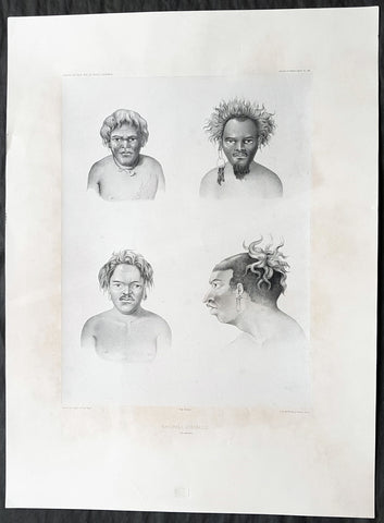
1842 D Urville & Goupil Antique Print of Men of Santa Isabel Isle, Solomon Isle.
- Title : Naturels D Isabelle (Isle Solomon)
- Size: 21in x 15in (535mm x 380mm)
- Condition: (A+) Fine Good Condition
- Date : 1842
- Ref #: 31745
Description:
This magnificent, large original antique lithograph print of profiles of 4 different men of the island of Santa Isabel of the Solomon Islands, visited in November & December 1838 by Dumont D Urville, drawn by Ernest Goupil, artist/draftsman aboard the Astrolabe during D Urvilles second voyage to the South Seas between 1837 - 1840, was engraved by Adolphe Jean-Baptiste Bayoti and was published in the 1842 1st edition of Dumont d Urvilles Voyage au Pole Sud et dans l Océanie sur les corvettes l Astrolabe et la Zélée : Exécuté par ordre du roi pendant les années 1837-1838-1839-1840.
These large magnificent lithographs from the 1st edition are extremely hard to find, most only found in museums or in private hands, and due to the artistry are a must for any collection.
Ernest Goupil was a French painter, draftsman and watercolourist He is known for the illustrations made as official painter for Dumont D Urvilles 2nd Voyage to the South Seas. In Voyage to the South Pole and in Oceania on corvettes l\'Astrobale and Zélée, executed by order of the king during the years 1837-1838-1839-1840, his drawings are transposed on stone, most notably by Emile Lassalle , Pharamond Blanchard and Adolphe Jean-Baptiste Bayot . Dumont d\'Urville relates: On the Zélée , Mr. Goupil fills his cartons with precious paintings, and on the Astrolabe , the young surgeon Le Breton, who has a remarkable talent in this genre, also performs at my asks for charming drawings.
Some drawings were sent to the Minister of the Navy and were shown to the King, who wanted to see them transposed into painting by the marine painter Théodore Gudin , but Goupil would not have given his consent.
In August 1839 in Samarang Java , the crew is struck by a violent epidemic, and after two months of suffering, Ernest Goupil succumbs and died on January 1 , 1840 ijn Hobart-town where he was buried with full military honours.
General Definitions:
Paper thickness and quality: - Heavy and stable
Paper color : - off white
Age of map color: -
Colors used: -
General color appearance: -
Paper size: - 21in x 15in (530mm x 380mm)
Plate size: - 21in x 15in (530mm x 380mm)
Margins: - Min 2in (50mm)
Imperfections:
Margins: - Light age toning
Plate area: - None
Verso: - None
Background:
Santa Isabel Island (also known as Isabel, Ysabel and Mahaga) is the longest in the Solomon Islands, the third largest in terms of surface area, and the largest in the group of islands in Isabel Province.
The first European contact to the Solomon Islands was made at Santa Isabel Island, by the Spanish explorer Álvaro de Mendaña on 7 February 1568. It was charted as Santa Isabel de la Estrella (St. Elizabeth of the Star of Bethlehem in Spanish). A settlement was established by the Spaniards, and a small boat (known in the accounts as the brigantine) was built to survey and chart the surrounding sea and islands. These local explorations led by Maestre de Campo Pedro Ortega Valencia and Alférez Hernando Enríquez resulted in the discoveries of the islands of Malaita, Guadalcanal, Savo, Vangunu, Choiseul, Makira, Ulawa, Malaupaina, Malaulalo, Ali\'ite, and Ugi Island. The Spanish immediately came into contact with Solomon Islanders and at first the relationship was cordial. However, the Spanish expedition\'s need for fresh food and water quickly led to tension and conflict, the Solomon Islanders’ subsistence economy being unable to provide continuous supplies to the Spanish.
Having found no gold and little food, and beset by attacks and sickness, the Spanish colonists shifted their colony to the site of today\'s Honiara on Guadalcanal, and the settlement on Santa Isabel was abandoned.
Santa Isabel islanders suffered attacks from blackbirding in the nineteenth century (the often brutal recruitment or kidnapping of labourers for the sugar plantations in Queensland and Fiji).
In April 1885 a German Protectorate was declared over the North Solomon Islands, including Santa Isabel Island. In 1900, under the terms of Treaty of Berlin (14 November 1899), Germany transferred the North Solomon Islands (except for Bougainville and its surrounding islands) to the British Solomon Islands Protectorate in exchange for the British giving up all claims to Samoa. Missionaries settled on Santa Isabel Island under both protectorates, converting most of the population to Christianity. In the early 20th century several British and Australian firms began large-scale coconut planting.
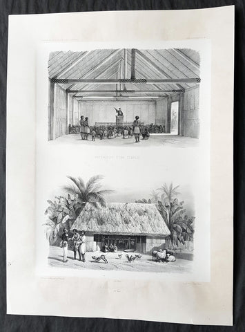
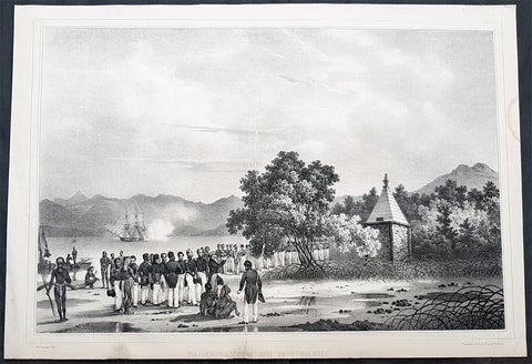
1842 D Urville & Le Breton Antique Print Church & Chief Tupou I Hut Vavau, Tonga
- Title : Interieur D un Temple: Habitation D un Chef (Isle Vavao)
- Size: 21in x 15in (535mm x 380mm)
- Condition: (A+) Fine Good Condition
- Date : 1842
- Ref #: 31750
Description:
This magnificent, large original antique lithograph print of the interior of the Protestant Church & Chief George Tupou I Hut both on the Tongan Island of Vavau , visited in October 1838 by Dumont D Urville in the ship The Astrolabe, was drawn by Louis Le Breton, asst. surgeon & artist/draftsman aboard the Astrolabe, during D Urvilles second voyage to the South Seas between 1837 - 1840, was engraved by Pharamond Blanchard and was published in the 1842 1st edition of Dumont d Urvilles Voyage au Pole Sud et dans l Océanie sur les corvettes l Astrolabe et la Zélée : Exécuté par ordre du roi pendant les années 1837-1838-1839-1840.
These large magnificent lithographs from the 1st edition are extremely hard to find, most only found in museums or in private hands, and due to the artistry are a must for any collection.
Louis Le Breton 1818 – 1866 was a French painter who specialised in marine paintings.
Le Breton studied medicine and took part in Dumont d Urville\'s second voyage aboard the Astrolabe. After the official illustrator of the expedition, Goupil, died, Le Breton replaced him.
From 1847 he devoted himself mainly to depicting marine subjects for the French Navy.
General Definitions:
Paper thickness and quality: - Heavy and stable
Paper color : - off white
Age of map color: -
Colors used: -
General color appearance: -
Paper size: - 21in x 15in (535mm x 380mm)
Plate size: - 21in x 15in (535mm x 380mm)
Margins: - Min 2in (50mm)
Imperfections:
Margins: - None
Plate area: - None
Verso: - None
Background:
Vavau is the island group of one large island (Utu Vavau) and 40 smaller ones in Tonga. It is part of Vavau District which includes several other individual islands. According to tradition the Maui god fished up both Tongatapu and Vavau but put a little more effort into the former. Vavau rises 204 metres (669 ft) above sea level at Mount Talau. The capital is Neiafu, which is the fifth largest city in Tonga, situated at the Port of Refuge (Puatalefusi or Lolo-a-Halaevalu).
Don Francisco Mourelle de la Rúa, commanding Spanish frigate Princesa was the first European to come to Vavau, on 4 March 1781. He charted Vavau as Martín de Mayorga who was the Viceroy of New Spain at the time. Captain James Cook knew about the islands a decade before, but the people in Haapai told him it would be no good for him to go there as there was no harbour. Apparently they did not want him to go there, and Cook heeded their advice anyway.
But Mourelle found excellent anchoring, of which he was in desperate need after having failed on Fonualei (Bitterness island) and Late, and he gave the spot the name Port of Refuge. But his original Port of Refuge was the bay on the west coast of the main island, near Longomapu. In 1793 Alessandro Malaspina visited for a month, following up on Mourelle and claiming the islands for Spain.
Tuʻi Tonga George Tupou I instituted the Vavau Code in Vavaʻu in 1839.
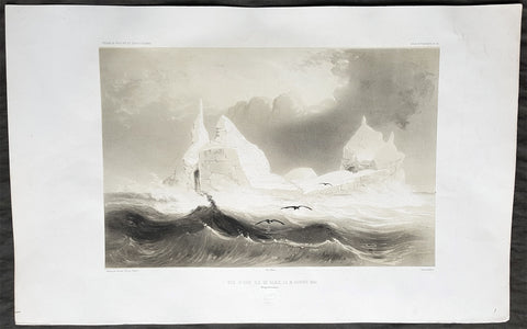
1842 D Urville & Le Breton Antique Print of Antarctica Adélie Land, January 1840
- Title : Vue D Une Ile de Glace L 18 Janvier 1840 (Parages Antarctiques)
- Size: 21in x 13in (535mm x 330mm)
- Condition: (A+) Fine Good Condition
- Date : 1842
- Ref #: 40417
Description:
This magnificent, large original antique lithograph print, one of the first ever views of Antarctica, specifically Terre Adélie named by D Urville after his wife, first sighted on January 18th 1840 by Dumont D Urville in the ship The Astrolabe, was drawn by Louis Le Breton, asst. surgeon & artist/draftsman aboard the Astrolabe, during D Urvilles second voyage to the South Seas between 1837 - 1840, was engraved by Léon Sabatier and was published in the 1842 1st edition of Dumont d UrvillesVoyage au Pole Sud et dans l Océanie sur les corvettes l Astrolabe et la Zélée : Exécuté par ordre du roi pendant les années 1837-1838-1839-1840.
These large magnificent lithographs from the 1st edition are extremely hard to find, most only found in museums or in private hands, and due to the artistry are a must for any collection.
Léon Jean-Baptiste Sabatier active 1827-1887. French lithographer, engraver and artist.
General Definitions:
Paper thickness and quality: - Heavy and stable
Paper color : - off white
Age of map color: -
Colors used: -
General color appearance: -
Paper size: - 21in x 13in (535mm x 330mm)
Plate size: - 21in x 13in (535mm x 330mm)
Margins: - Min 2in (50mm)
Imperfections:
Margins: - None
Plate area: - None
Verso: - None
Background:
Between May 1838 and October 1839 d\'Urville led the ASTROLABE and ZÈLÈE on an exploring adventure across the breadth of the Pacific Ocean. The scurvy suffered in southern waters was now replaced with fever and dysentery which cost the lives of 14 men and officers during the voyage. Another six died in Hobart, Tasmania which was his departure point for his third attempt at reaching the Antarctic mainland.
On January 2, 1840 the ships were headed out to sea. Within a week, the surgeons reported a total of 16 men ill with seasickness due to the constant rolling of the seas. By January 18th they crossed the 64th parallel. At 6 o\'clock the following morning the lookouts counted half a dozen huge icebergs nearby. By 6 o\'clock that evening they were surrounded by at least 59. The hydrographer, Dumoulin, climbed the rigging of the ASTROLABE and reported \'an appearance of land\'. The belief that land was near raised the spirits of all those aboard. At 9 o\'clock the sun was still above the horizon and at 10:50 PM d\'Urville wrote that the sun disappeared \'and showed up the raised contour of land in all its sharpness. Everyone had come together on to the deck to enjoy the magnificent spectacle\'. On January 20 d\'Urville wrote \'...before us rose the land; one could distinguish the details of it...Unfortunately an unbroken calm prevented us from approaching it to make the matter certain. Nevertheless, joy reigned on board; henceforth the success of our enterprise was assured\'. Despite a light breeze, by the middle of the following day they were within four miles of land. Showing no signs of a safe place to go ashore, they turned west, following the coast, until 6 PM when a boat was lowered so that Dumoulin could take sightings from one of the icebergs. Another boat was launched from the ZÈLÈE and by 9 PM the two boats reached an islet only a few hundred yards off the coast. The officers and men struggled ashore, shoving aside penguins in the process, and planted a flag claiming the land in the name of France. The men then set about exploring the islet, searching for any life. They unfortunately found nothing but a few chips of granite which was enough to prove that they had landed on firm ground rather than an iceberg. Recording the landing and departure, officer Joseph-Fidéle-Eugéne Dobouzet wrote \'...We saluted our discovery with a general hurrah...The echoes of these silent regions, for the first time disturbed by human voices, repeated our cries and then returned to their habitual silence\'. The boats rowed back to their respective ships and Dumont d\'Urville promptly named the mainland Terre Adélie after his wife\'s name. The wide stretch of water along its shore is now known as the Dumont d\'Urville Sea.
Almost immediately the weather turned brutal with temperatures dropping to below freezing and whirlwinds of snow surrounding the ships. In the confusion, the ASTROLABE lost contact with the ZÈLÈE creating intense fear among the crewmembers of being driven into an iceberg or on top of the icepack itself. The ASTROLABE struggled in seas with waves spilling over onto her decks causing her to heel over at such an angle that the leeward battery was almost entirely covered by the sea. By January 29 the ships were moving rapidly southwest with only a few icebergs in sight. A little after 4 o\'clock in the afternoon a very surprised lookout spotted an approaching ship closing fast. The westbound vessel was the PORPOISE, the American ship of the United States Exploring Expedition commanded by Charles Wilkes. No signals were exchanged and no greetings exchanged. The PORPOISE sailed quickly to the west while the ASTROLABE headed north.
Dumont d\'Urville spent eight more months exploring southern waters. He returned to Hobart, sailed on to New Zealand, turned north to New Guinea and Timor, north again to St. Helena Island and on November 6, 1840, the two ships entered the harbor at Toulon. They had been away three years and two months.
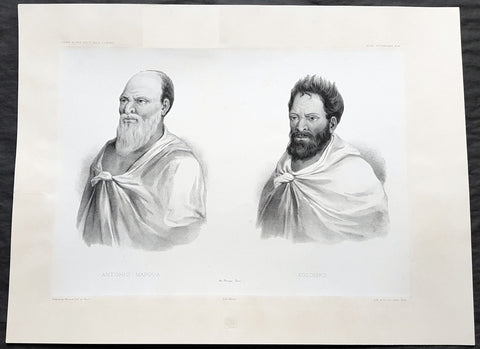
1842 D Urville & Marescot Antique Print King Mapou-Teoa & Envoy of Mangareva Gambier
- Title : Antonio Mapoua; Koloupo (Isles Manga Reva)
- Size: 21in x 15in (535mm x 380mm)
- Condition: (A+) Fine Good Condition
- Date : 1842
- Ref #: 31747
Description:
This large, magnificent, original antique lithograph print of King Mapou-Teoa and his envoy who boarded D Urvilles ship the Astrolabe in August 1838, by Jacques Marescot-Duthilleul, one of the artists,draftsman aboard the Astrolabe, during D Urvilles second voyage to the South Seas between 1837 - 1840, was engraved by Adolphe Jean-Baptiste Bayot and published in the 1842 1st edition of Dumont d UrvillesVoyage au Pole Sud et dans l Océanie sur les corvettes l Astrolabe et la Zélée : Exécuté par ordre du roi pendant les années 1837-1838-1839-1840.
These large magnificent lithographs from the 1st edition are extremely hard to find, most only found in museums or in private hands, and due to the artistry are a must for any collection.
Jacques, Marie, Eugene Marescot Duthilleul1809 - 1839 Lieutenant in the French navy and artist who accompanied Dumont D Urville on the Corvette The Astrolabe on D Urvilles 2nd Voyage to the South Seas, Australia and Antarctica between 1837 and 1840. He was responsible for a number of exquisite drawings of peoples and views during the voyage that were later used for lithograph prints for publication
In 1837, a new mission of exploration in the southern Pacific Ocean was entrusted by King Louis-Philippe to Captain Dumont d Urville. This mission included improvement of scientific knowledge on the islands of the South Pacific and Indonesia, and exploration of the Antarctic continent.
The first phase of the expedition was the crossing the Sea of Weddel sea ice, on the coast of the Antarctic Ice Sheet. The second phase between May 1838 &o December 1839 consisting of visits to many South Pacific Islands: Marquesas, Polynesia, Fiji, Solomon Islands, New Guinea, Carolinas, Marianas, Moluccas and finally Sunda Islands.
At the end of this second phase, after eighteen months of difficult navigation in unhealthy climates, the sanitary condition of the crews of the two corvettes reached a critical state. During the last voyage from Sumatra (Lampang Bay) to Hobart Tasmania, eighteen patients died, including Lieutenant Marescot-Duthilleul.
General Definitions:
Paper thickness and quality: - Heavy and stable
Paper color : - off white
Age of map color: -
Colors used: -
General color appearance: -
Paper size: - 21in x 15in (535mm x 380mm)
Plate size: - 21in x 15in (535mm x 380mm)
Margins: - Min 2in (50mm)
Imperfections:
Margins: - Repair to top margin, no loss
Plate area: - None
Verso: - None
Background:
Mangareva is the central and largest island of the Gambier Islands in French Polynesia. It is surrounded by smaller islands: Taravai in the southwest, Aukena and Akamaru in the southeast, and islands in the north.
Mangareva was once heavily forested and supported a large population that traded with other islands via canoes. However, excessive logging by the islanders during the 10th to the 15th centuries resulted in deforestation of the island, with disastrous results for its environment and economy.
The first European to arrive at Mangareva was British Captain James Wilson in 1797 on the ship Duff. Wilson named the island group in honour of Admiral James Gambier, who had helped him to equip his vessel.
Mangareva along with its dependencies in the Gambier Islands were ruled by a line of kings and later regents that ruled until the French formally annexed the islands in 1881. A French protectorate was requested on 16 February 1844 by King Maputeoa but was never ratified by the French government. On 4 February 1870, Prince Regent Arone Teikatoara and the Mangarevan government formally withdrew the protectorate request and asked the French to not intervene in the kingdom\'s affairs. After Father Honoré Laval was removed to Tahiti, the native government changed its stance and an agreement between Prince Regent Arone and the French colonial authority in Tahiti was signed reaffirming the protectorate status on 30 November 1871. The Gambier Islands were finally annexed on 21 February 1881 under Prince Regent Bernardo Putairi and approved by the President of France on 30 January 1882.
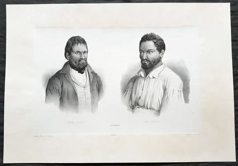
1842 D Urville & Marescot Antique Print of Envoys of Mangareva Isle, Gambier Is.
- Title : Mama-Houi; Tima-Temouo (Isles Maga Reva)
- Size: 21in x 15in (535mm x 380mm)
- Condition: (A+) Fine Good Condition
- Date : 1842
- Ref #: 31746
Description:
This large, magnificent, original antique lithograph print of Envoys of Mangreva Island, Gambier Island visited by Dumont D Urvilles & his ship the Astrolabe in August 1838, by Jacques Marescot-Duthilleul, one of the artists,draftsman aboard the Astrolabe, during D Urvilles second voyage to the South Seas between 1837 - 1840, was engraved by Adolphe Jean-Baptiste Bayot and published in the 1842 1st edition of Dumont d UrvillesVoyage au Pole Sud et dans l Océanie sur les corvettes l Astrolabe et la Zélée : Exécuté par ordre du roi pendant les années 1837-1838-1839-1840.
These large magnificent lithographs from the 1st edition are extremely hard to find, most only found in museums or in private hands, and due to the artistry are a must for any collection.
Jacques, Marie, Eugene Marescot Duthilleul1809 - 1839 Lieutenant in the French navy and artist who accompanied Dumont D Urville on the Corvette The Astrolabe on D Urvilles 2nd Voyage to the South Seas, Australia and Antarctica between 1837 and 1840. He was responsible for a number of exquisite drawings of peoples and views during the voyage that were later used for lithograph prints for publication
In 1837, a new mission of exploration in the southern Pacific Ocean was entrusted by King Louis-Philippe to Captain Dumont d Urville. This mission included improvement of scientific knowledge on the islands of the South Pacific and Indonesia, and exploration of the Antarctic continent.
The first phase of the expedition was the crossing the Sea of Weddel sea ice, on the coast of the Antarctic Ice Sheet. The second phase between May 1838 &o December 1839 consisting of visits to many South Pacific Islands: Marquesas, Polynesia, Fiji, Solomon Islands, New Guinea, Carolinas, Marianas, Moluccas and finally Sunda Islands.
At the end of this second phase, after eighteen months of difficult navigation in unhealthy climates, the sanitary condition of the crews of the two corvettes reached a critical state. During the last voyage from Sumatra (Lampang Bay) to Hobart Tasmania, eighteen patients died, including Lieutenant Marescot-Duthilleul.
General Definitions:
Paper thickness and quality: - Heavy and stable
Paper color : - off white
Age of map color: -
Colors used: -
General color appearance: -
Paper size: - 21in x 15in (535mm x 380mm)
Plate size: - 21in x 15in (535mm x 380mm)
Margins: - Min 2in (50mm)
Imperfections:
Margins: - None
Plate area: - None
Verso: - None
Background:
Mangareva is the central and largest island of the Gambier Islands in French Polynesia. It is surrounded by smaller islands: Taravai in the southwest, Aukena and Akamaru in the southeast, and islands in the north.
Mangareva was once heavily forested and supported a large population that traded with other islands via canoes. However, excessive logging by the islanders during the 10th to the 15th centuries resulted in deforestation of the island, with disastrous results for its environment and economy.
The first European to arrive at Mangareva was British Captain James Wilson in 1797 on the ship Duff. Wilson named the island group in honour of Admiral James Gambier, who had helped him to equip his vessel.
Mangareva along with its dependencies in the Gambier Islands were ruled by a line of kings and later regents that ruled until the French formally annexed the islands in 1881. A French protectorate was requested on 16 February 1844 by King Maputeoa but was never ratified by the French government. On 4 February 1870, Prince Regent Arone Teikatoara and the Mangarevan government formally withdrew the protectorate request and asked the French to not intervene in the kingdom\'s affairs. After Father Honoré Laval was removed to Tahiti, the native government changed its stance and an agreement between Prince Regent Arone and the French colonial authority in Tahiti was signed reaffirming the protectorate status on 30 November 1871. The Gambier Islands were finally annexed on 21 February 1881 under Prince Regent Bernardo Putairi and approved by the President of France on 30 January 1882.
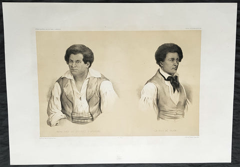
1842 D Urville & Marescot Antique Print of The Chief & Son of Upolu Island Samoa
- Title : Peha, Chef du District D Opoulou; Le Fils de Peha
- Size: 21in x 15in (535mm x 380mm)
- Condition: (A+) Fine Good Condition
- Date : 1842
- Ref #: 31748
Description:
This large, magnificent, original antique lithograph print of Chief Peha & his son, of the Island of Upolu, Samoa visited by Dumont D Urville on the ship Astrolabe in September 1838, by Jacques Marescot-Duthilleul, artist on the Astrolabe, who died during D Urvilles second voyage to the South Seas, between 1837 - 1840, was engraved by Adolphe Jean-Baptiste Bayot and published in the 1842 1st edition of Dumont d Urvilles Voyage au Pole Sud et dans l Océanie sur les corvettes l Astrolabe et la Zélée : Exécuté par ordre du roi pendant les années 1837-1838-1839-1840.
These large magnificent lithographs from the 1st edition are extremely to find, most only found in museums or in private hands, and are a must for any collection.
Jacques, Marie, Eugene Marescot Duthilleul1809 - 1839 Lieutenant in the French navy and artist who accompanied Dumont D Urville on the Corvette The Astrolabe on D Urvilles 2nd Voyage to the South Seas, Australia and Antarctica between 1837 and 1840. He was responsible for a number of exquisite drawings of peoples and views during the voyage that were later used for lithograph prints for publication
In 1837, a new mission of exploration in the southern Pacific Ocean was entrusted by King Louis-Philippe to Captain Dumont d Urville. This mission included improvement of scientific knowledge on the islands of the South Pacific and Indonesia, and exploration of the Antarctic continent.
The first phase of the expedition was the crossing the Sea of Weddel sea ice, on the coast of the Antarctic Ice Sheet. The second phase between May 1838 &o December 1839 consisting of visits to many South Pacific Islands: Marquesas, Polynesia, Fiji, Solomon Islands, New Guinea, Carolinas, Marianas, Moluccas and finally Sunda Islands.
At the end of this second phase, after eighteen months of difficult navigation in unhealthy climates, the sanitary condition of the crews of the two corvettes reached a critical state. During the last voyage from Sumatra (Lampang Bay) to Hobart Tasmania, eighteen patients died, including Lieutenant Marescot-Duthilleul.
General Definitions:
Paper thickness and quality: - Heavy and stable
Paper color : - off white
Age of map color: -
Colors used: -
General color appearance: -
Paper size: - 21in x 15in (535mm x 380mm)
Plate size: - 21in x 15in (535mm x 380mm)
Margins: - Min 2in (50mm)
Imperfections:
Margins: - None
Plate area: - None
Verso: - None
Background:
Upolu is an island in Samoa, formed by a massive basaltic shield volcano which rises from the seafloor of the western Pacific Ocean. The island is 75 kilometres long, 1,125 square kilometres in area, and is the second largest in geographic area as well as with 135,000 people the most populated of the Samoan Islands. Upolu is situated to the southeast of the big island, Savai i. The capital Apia is in the middle of the north coast with Faleolo International Airport at the western end of the island. The island has not had any historically recorded eruptions, although three lava flows date back only a few hundred to a few thousand years.
In the Samoan branch of Polynesian mythology, Upolu was the first woman on the island of the same name.
In 1841, the island was the site of the Bombardment of Upolu, an incident during the United States Exploring Expedition.
In the late-19th century, the Scottish writer Robert Louis Stevenson owned a 400-acre (160-hectare) estate at Vailima village and died there in 1894. He is buried at the top of Mount Vaea above his former home. The Vailima estate was purchased in 1900 as the official residence for the German governor and, after British/Dominion confiscation, served successively as residence for the New Zealand administrator and for the Samoan head of state after independence.
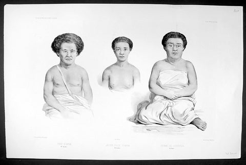
C1842 D Urville & Goupil Antique Print Chief Pea, Daughter & Wife of Apia, Samoa
- Title : Chef D Apia (Ise Opoulou): Jeune Fille D Apia (Ile Opoulou): Femme De Lefouga (Iles Hapai)
- Size: 22in x 14in (560mm x 370mm)
- Condition: (A+) Fine Good Condition
- Date : 1842
- Ref #: 31754
Description:
This magnificent, large original antique lithograph print of Pea the High Chief of the village of Apia on the Island of Upolu, Samoa along with and his daughter & wife visited in September 1838 by Dumont D Urville, by Ernest Goupil, the senior artist/draftsman aboard the Astrolabe, during D Urvilles second voyage to the South Seas between 1837 - 1840, was engraved by Adolphe Jean-Baptiste Bayotiand was published in the 1842 1st edition of Dumont d Urvilles Voyage au Pole Sud et dans l Océanie sur les corvettes l Astrolabe et la Zélée : Exécuté par ordre du roi pendant les années 1837-1838-1839-1840.
These large magnificent lithographs from the 1st edition are extremely hard to find, most only found in museums or in private hands, and due to the artistry are a must for any collection.
Ernest Goupil was a French painter, draftsman and watercolourist He is known for the illustrations made as official painter for Dumont D Urvilles 2nd Voyage to the South Seas. In Voyage to the South Pole and in Oceania on corvettes l\'Astrobale and Zélée, executed by order of the king during the years 1837-1838-1839-1840, his drawings are transposed on stone, most notably by Emile Lassalle , Pharamond Blanchard and Adolphe Jean-Baptiste Bayot . Dumont d\'Urville relates: On the Zélée , Mr. Goupil fills his cartons with precious paintings, and on the Astrolabe , the young surgeon Le Breton, who has a remarkable talent in this genre, also performs at my asks for charming drawings.
Some drawings were sent to the Minister of the Navy and were shown to the King, who wanted to see them transposed into painting by the marine painter Théodore Gudin , but Goupil would not have given his consent.
In August 1839 in Samarang Java , the crew is struck by a violent epidemic, and after two months of suffering, Ernest Goupil succumbs and died on January 1 , 1840 ijn Hobart-town where he was buried with full military honours.
General Definitions:
Paper thickness and quality: - Heavy and stable
Paper color : - off white
Age of map color: -
Colors used: -
General color appearance: -
Paper size: - 22in x 14in (560mm x 370mm)
Plate size: - 22in x 14in (560mm x 370mm)
Margins: - Min 2in (50mm)
Imperfections:
Margins: - None
Plate area: - None
Verso: - None
Background:
Apia is the capital and the largest city of Samoa. From 1900 to 1919, it was the capital of German Samoa. The city is located on the central north coast of Upolu, Samoa\'s second largest island. Apia is the only city in Samoa and falls within the political district (itūmālō) of Tuamasaga.
Apia was originally a small village from which the country\'s capital took its name. Apia village still exists within the larger modern capital of Apia which has grown into a sprawling urban area with many villages. Like every other settlement in the country, Apia village has its own matai chiefly leaders and fa\'alupega (genealogy and customary greetings) according to fa a Samoa.
The modern capital Apia was founded in the 1850s and has been the official capital of Samoa since 1959.
The harbor was also the site of an infamous 15 March 1889 naval standoff in which seven ships from Germany, the US, and Britain refused to leave harbor while a typhoon was clearly approaching, lest the first moved would lose face. All the ships were sunk, except the British cruiser Calliope, which barely managed to leave port at 1 mile per hour and ride out the storm. Nearly 200 American and German lives were lost, as well as six ships sunk or damaged beyond repair.