John Harrison
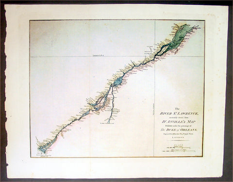
1780 Harrison Antique Map of The St Lawrence River, Canada
- Title : The River St. Lawrence, Accurately Drawn from d'Anville's Map, Published ....
- Date : 1780
- Condition: (A+) Fine Condition
- Ref: 16294
- Size: 21in x 16 1/2in (535mm x 420mm)
Description:
This large beautifully engraved hand coloured original antique map of the St Lawrence River, Canada was published by John Harrison in 1780.
Background:
In 1535 two Indian youths told Jacques Cartier about the route to "Kanata." They were referring to the village of Stadacona; Kanata was simply the Huron-Iroquois word for village or settlement. This modest, generic name stuck. Cartier used "Canada" to refer to the entire area subject to its chief, Donnacona. The name was soon applied to a much larger area: maps in 1547 designated everything north of the St. Lawrence River as "Canada." Cartier also called The St. Lawrence River the "Riviere de Canada," a name used until the early 1600s. By 1616, although the entire region was formally known as New France, the area along the great river was still called Canada. Explorers and fur traders opened up territory to the west and to the south and the area depicted as Canada grew. In the early 1700s the name referred to all lands in what is now the American Midwest and as far south as present day Louisiana. The first use of "Canada" as an official name came in 1791 when the Province of Quebec was divided into the colonies of Upper and Lower Canada. In 1841, the two Canadas were again united under one name, the Province of Canada. At the time of Confederation in 1867, the new country assumed the title The Dominion of Canada. There were only four provinces Ontario, Quebec, Nova Scotia and New Brunswick. There are now ten provinces and three territories. (Ref: M&B; Tooley)
General Description:
Paper thickness and quality: - Heavy & stable
Paper color: - White
Age of map color: - Early
Colors used: - Green, yellow
General color appearance: - Authentic
Paper size: - 21in x 16 1/2in (535mm x 420mm)
Plate size: - 18in x 14in (460mm x 355mm)
Margins: - Min 1in (25mm)
Imperfections:
Margins: - None
Plate area: - Folds as issued
Verso: - None
1789 John Harrison Large Antique Map of Western Europe - Italy to Germania to UK
- Title : Germanie, France, Italie, Espange, Isles Britanniques Dans un Age intermediare de L Ancienne Geographie et de la Moderne Drawn & engraved from D Anvilles Atlas for John Harrison...1789
- Date : 1789
- Size: 19in x 16 1/2in (480mm x 420mm)
- Condition: (A+) Fine Condition
- Ref: 15645
Description:
This large magnificent original copper-plate engraved antique map of Western Europe, after J B D Anville, was engraved in 1789 - dated in the title - and was published for John Harrisons Ancient & Modern Atlas
General Definitions:
Paper thickness and quality: - Heavy and stable
Paper color : - off white
Age of map color: -
Colors used: -
General color appearance: -
Paper size: - 19in x 16 1/2in (480mm x 420mm)
Plate size: - 19in x 14in (480mm x 355mm)
Margins: - Min 1/2in (8mm)
Imperfections:
Margins: - None
Plate area: - Folds as issued
Verso: - None
Background:
The Roman Empire was the post-Roman Republic period of the ancient Roman civilization, with a government headed by emperors and large territorial holdings around the Mediterranean Sea in Europe, Africa and Asia. The city of Rome was the largest city in the world c. 100 BC – c. AD 400, with Constantinople (New Rome) becoming the largest around AD 500, and the Empire\\\'s population grew to an estimated 50 to 90 million inhabitants (roughly 20% of the world\\\'s population at the time) The 500-year-old republic which preceded it had been severely destabilized in a series of civil wars and political conflict, during which Julius Caesar was appointed as perpetual dictator and then assassinated in 44 BC. Civil wars and executions continued, culminating in the victory of Octavian, Caesar\\\'s adopted son, over Mark Antony and Cleopatra at the Battle of Actium in 31 BC and the annexation of Egypt. Octavian\\\'s power was then unassailable and in 27 BC the Roman Senate formally granted him overarching power and the new title Augustus, effectively marking the end of the Roman Republic.