James Wyld

1830 Wyld Large Folding Antique Map Eastern Europe, Russia to Turkey, Ukraine
- Title :
- Ref #: 80506
- Size: 63in x 33in (1.6m x 840mm)
- Date : 1830
- Condition: (A+) Fine Condition
Description:
This extremely large large original antique folding map (dissected into 56 sections on linen) of eastern Europe, Russia & Turkey - the eastern part of a huge two part map of Europe - was published in ca 1830 by James Wyld, Charing Cross East London.
This is a huge map and highly detailed stretching from Scandinavia in the north to Cyprus in the south and Lithuania and the Hungarian Empire in the west to Russia & Central Asia in the east with an amazing amount of detail. (Ref: M&B; Tooley;Clancy)
General Description:
Paper thickness and quality: - Heavy and stable
Paper color: - white
Age of map color: - Original
Colors used: - Yellow, green, blue, red
General color appearance: - Authentic
Paper size: - 63in x 33in (1.6m x 840mm)
Margins: - min. 1/2in (12mm)
Imperfections:
Margins: - Light soiling
Plate area: Light soiling
Verso: - Light soiling
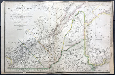
1839 James Wyld Large Antique Map Provinces of Lower Canada, St Lawrence River
- Title : A New Map of the Province of Lower Canada, Describing all the Seigneuries, Townships, Grants of Land, &c. Compiled from Plans deposited in the Patent Office Quebec: by Samuel Holland, Esq. Surveyor General
- Ref #: 50391
- Size: 35 1/4in x 23 1/4in (895mm x 590mm)
- Date : 1839
- Condition: (B) Good Condition
Description:
This large, rare hand coloured original antique map of the provinces of Lower Canada and The St Lawrence River was engraved in 1839 - dated in title - and was published by James Wyld, Charing Cross, London.
This map has undergone some repairs and is priced accordingly. Currently this map is priced as high as $1500.
Background:
This boldly engraved map extends westward to include Lake St. Francis and the extreme tip of Upper Canada, eastward to part of New Brunswick showing the River St. John and beyond, and south to just below the Canadian border with New York and Vermont. It is filled with towns and settlements and individual named townships, roads and trails. It includes several interesting notations and delineates the "Boundary awarded to the King of Holland." Samuel Holland was originally a Dutch surveyor who fought on the side of the British during the French and Indian Wars and served as Surveyor General for the Province of Quebec and the Northern District of America. An infrequently seen issue.
This updated example of this important map of the Lower Province of Canada, first issued by Faden in 1813, which identifies in manuscript the location of the disputed lands southeast of the St. Lawrence River, the so-called "English Line" and "American Line," which would be the subject of an early boundary dispute between the two countries.
The original Faden map included information concerning over 100 land grants on either side of the St. Lawrence River, including the names of Land Owners. Faden's orginal map showed the surveys conducted in 1796-98 along the Scoudiac and Magaguadavic Rivers, in order to ascertain the true location of the St. Croix River. In the present map, there is significant new information and topographcal details, showing the remarkable advancement in the surveying of the region in the 12 years after the publication of Faden's map of 1813.
This new addition includes the District of Maine, Moosehad Lake, Penobscot River and the Bowding County Township and Bingham's Purchase. Whereas the original Faden map had no topographical detail, the present map is a dramatic improvement.
In addition to the topographical improvements, there is now an annotation in the centre of the map identifying the boundary dispute in the region, relating to the existence of two St. Croix Rivers in the region.
The second article of the Treaty of Peace between the US and Britain included the setting of the boundary between the two nations, "From the northwest angle of Nova Scotia, viz., that angle which is formed by a line drawn due north from the source of St. Croix River to the highlands . . ." It later became apparent that there was more than one St. Croix River. A further treaty provision in 1794 appointed a boundary commission, which determined in 1798 that the intended St. Croix was the Schoodiac River and its northern branch Cheputnaticook. The Treaty of Ghent, concluded on December 24, 1814, agreed to provide for a final adjustment of the boundaries described in the Treaty of 1783 that had not yet been determined, which included the boundary line from the source of the River St. Croix to the most north-western point of the Lake of the Woods.
A further commission was appointed to settle the boundary from the St. Croix to the St. Lawrence. Joseph Bouchette and John Lawrence were hired to conduct the surveys and the reports submitted for resolution to a third nation and ultimately resolved by the Webster-Ashburton Treaty of 1842.
The present map shows the two boundary claims at a time when they were not yet fully resolved. (Ref: M&B; Tooley; Clancy)
General Description:
Paper thickness and quality: - Heavy and stable
Paper color: - white
Age of map color: - Original
Colors used: - Yellow, green, blue, red
General color appearance: - Authentic
Paper size: - 35 1/4in x 23 1/4in (895mm x 590mm)
Plate size: - 35 1/4in x 23 1/4in (895mm x 590mm)
Margins: - min. 1/4in (5mm)
Imperfections:
Margins: - Light soiling, repair to bottom right margin , border into image
Plate area: Light soiling, creasing along left fold
Verso: - Light soiling, repairs as noted
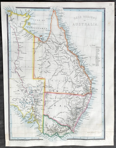
1855 James Wyld Scarce Antique Map of Australian Early Goldfields
- Title : Gold Regions of Australia
- Date : 1855
- Size: 13 1/2in x 10 1/2in (345mm x 270mm)
- Condition: (A+) Very Good Condition
- Ref: 27006
Description:
This original hand coloured copper-plate engraved antique early Gold Fields map of Eastern Australia was published by James Wyld in 1855.
This scarce map was published very early on, in the discovery of gold in Australia, in 1851. Once gold was discovered by Hargraves, the number of discoveries made Australia, in a short period of time, one of the richest places on earth.
General Definitions:
Paper thickness and quality: - Heavy and stable
Paper color : - off white
Age of map color: - Original
Colors used: - Yellow, pink, blue, green
General color appearance: - Authentic
Paper size: - 13 1/2in x 10 1/2in (345mm x 270mm)
Plate size: - 13 1/2in x 10 1/2in (345mm x 270mm)
Margins: - Min 1/2in (12mm)
Imperfections:
Margins: - None
Plate area: - Bottom section of map rejoined
Verso: - None
Background:
The first gold rush in Australia began in May 1851 after prospector Edward Hargraves claimed to have discovered payable gold near Orange, at a site he called Ophir. Hargraves had been to the Californian goldfields and had learned new gold prospecting techniques such as panning and cradling. Hargraves was offered rewards by the Colony of New South Wales and the Colony of Victoria. Before the end of the year, the gold rush had spread to many other parts of the state where gold had been found, not just to the west, but also to the south and north of Sydney.
The Australian gold rushes changed the convict colonies into more progressive cities with the influx of free immigrants. These hopefuls, termed diggers, brought new skills and professions, contributing to a burgeoning economy. The mateship that evolved between these diggers and their collective resistance to authority led to the emergence of a unique national identity. Although not all diggers found riches on the goldfields, many decided to stay and integrate into these communities.
In July 1851, Victoria\'s first gold rush began on the Clunes goldfield. In August, the gold rush had spread to include the goldfield at Buninyong (today a suburb of Ballarat) 45 km (28 m) away and, by early September 1851, to the nearby goldfield at Ballarat (then also known as Yuille\'s Diggings) followed in early September to the goldfield at Castlemaine (then known as Forest Creek and the Mount Alexander Goldfield) and the goldfield at Bendigo (then known as Bendigo Creek) in November 1851. Gold, just as in New South Wales, was also found in many other parts of the state. The Victorian Gold Discovery Committee wrote in 1854:
The discovery of the Victorian Goldfields has converted a remote dependency into a country of world wide fame; it has attracted a population, extraordinary in number, with unprecedented rapidity; it has enhanced the value of property to an enormous extent; it has made this the richest country in the world; and, in less than three years, it has done for this colony the work of an age, and made its impulses felt in the most distant regions of the earth.
When the rush began at Ballarat, diggers discovered it was a prosperous goldfield. Lieutenant-Governor, Charles La Trobe visited the site and watched five men uncover 136 ounces of gold in one day. Mount Alexander was even richer than Ballarat. With gold sitting just under the surface, the shallowness allowed diggers to easily unearth gold nuggets. In 7 months, 2.4 million pounds of gold was transported from Mount Alexander to nearby capital cities.
The gold rushes caused a huge influx of people from overseas. Australia\'s total population more than tripled from 430,000 in 1851 to 1.7 million in 1871. Australia first became a multicultural society during the gold rush period. Between 1852 and 1860, 290,000 people migrated to Victoria from the British Isles, 15,000 came from other European countries, and 18,000 emigrated from the United States. Non-European immigrants, however, were unwelcome, especially the Chinese.
The Chinese were particularly industrious, with techniques that differed widely from the Europeans. This and their physical appearance and fear of the unknown led to them to being persecuted in a racist way that would be regarded as untenable today.
In 1855, 11,493 Chinese arrived in Melbourne. Chinese travelling outside of New South Wales had to obtain special re-entry certificates. In 1855, Victoria enacted the Chinese Immigration Act 1855, severely limiting the number of Chinese passengers permitted on an arriving vessel. To evade the new law, many Chinese were landed in the south-east of South Australia and travelled more than 400 km across country to the Victorian goldfields, along tracks which are still evident today.
In 1885, following a call by the Western Australian government for a reward for the first find of payable gold, a discovery was made at Halls Creek, sparking a gold rush in that state.
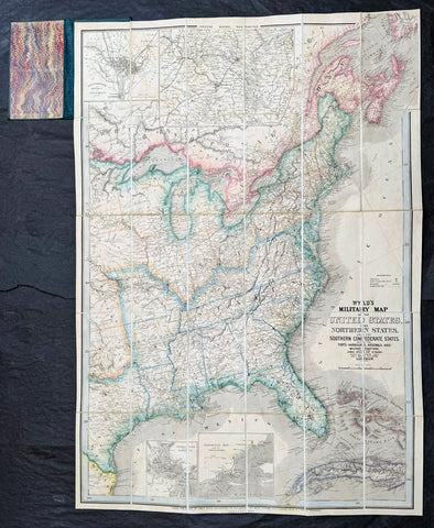
1865 James Wyld Large Antique Folding American Civil War Map - Extremely Rare
- Title : Wyld's Military Map Of The United States, The Northern States, And The Southern Confederate States: With The Forts, Harbours, Arsenals And Military Positions. James Wyld, 457 Strand; Charing Cross East And 2, Royal Exchange London. ......London, Published By James Wyld, Geographer To The Queen
- Date : 1865
- Size: 34 1/2in x 24in (875mm x 610mm)
- Condition: (A+) Fine Condition
- Ref: 35660
Description:
A very rare map of the United States first issued in 1861, during the Secession Crises that preceded the outbreak of the American Civil War, with this rare edition issued in January 1865 - dated at the foot of the map, only 4 months before the end of the war..
There are a few 1861 editions of this map for sale, currently on the market, but I have been unable to find an 1865 edition, either currently on the market or sold in the past.
General Definitions:
Paper thickness and quality: - Heavy and stable
Paper color : - off white
Age of map color: - Original
Colors used: - Yellow, green, blue, pink
General color appearance: - Authentic
Paper size: - 34 1/2in x 24in (875mm x 610mm)
Plate size: - 34 1/2in x 24in (875mm x 610mm)
Margins: - Min 1/2in (12mm)
Imperfections:
Margins: - None
Plate area: - None
Verso: - None
Background:
Wyld was particularly masterful at capturing political events throughout the world as they happened and leveraging his impressive publishing operation to quickly produce and distribute pertinent to the invested public. In this case, the map distinguishes between the 'Northern States' (orange border) and the 'Southern Confederate States' (blue border). Wyld here erroneously conflates slaveholding states with Confederate secessionist states - in particular, Missouri, Kentucky, Delaware, and Maryland, which allowed slavery but remained loyal to the Union. Arsenals, forts, and military posts highlighted and keyed, underscoring that 'war' was very much in the air. The map is also noteworthy for recognizes the apocryphal territory 'Chippewa', roughly corresponding to modern-day North Dakota.
This map is scarce to the market. Known institutions holdings at the Boston Public Library, the Library of Congress, Bibliothèque nationale de France, the David Rumsey Collection, among others. (Ref: M&B; Tooley; Clancy) (Ref: Tooley, Koeman, Burden)
Please note all items auctioned are genuine, we do not sell reproductions. A Certificate of Authenticity (COA) can be issued on request.