J B Homann
1707 Homann Rare Ist Edition Twin Hemisphere World Antique Map, California Isle.
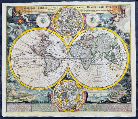
- Title : Planiglobii Terrestris Cum Utroq. Hemisphaerio Caelesti Generalis Exhibitio.
- Date : 1707
- Size: 23 1/2in x 20 1/2in (600mm x 520mm)
- Condition: (A) Very Good Condition
- Ref: 61006
Description:
This large beautifully hand coloured original scarce first edition copper plate engraved antique twin hemisphere world map by Johann Baptist Homann was engraved in 1707 and published in Homanns 1710 edition of Neuer Atlas.
Later editions of the map is commonly misidentified as first editions. In later editions the words Cum Priviligo (Imperial privilege or permission) are engraved in the title, this privilege was later awarded to the Homanns and included in all future maps. In later editions California is shown as a peninsular and not an Island as shown in this map.
General Definitions:
Paper thickness and quality: - Heavy and stable
Paper color : - off white
Age of map color: - Original & later
Colors used: - Yellow, green, blue, pink
General color appearance: - Authentic
Paper size: - 23 1/2in x 20 1/2in (600mm x 520mm)
Plate size: - 22 1/4in x 19 1/4in (515mm x 490mm)
Margins: - Min 1/2in (12mm)
Imperfections:
Margins: - Light soiling
Plate area: - Professional paper rejoin left margin 2in into image, no loss. Light age toning
Verso: - Light soiling
Background:
The map evokes the Dutch maps of the previous century, featuring an insular California and a depiction of Australia and the South Pacific that resembles that of Abel Tasman. Homann nonetheless incorporated a significant detail from the state-of-the-art maps of the Parisian geographer Guillaume De l'Isle, and the English polymath Edmund Halley. The map is a rich compendium of explorers' routes, including Magellan, Tasman, Gaetani, and Chaumont, as well as the extremely current voyages of Dampier (whose discovery of Nova Britannia near New Guinea is shown with a date of 1700). Above and below the cruxes of the main hemispheres are a pair of celestial hemispheres. At the bottom is a beautifully engraved panorama illustrating volcanoes, earthquakes, the tides, marine vortices, rain, and rainbows. These themes are significant in that they are neither mythological nor allegorical: they are plainly discussed natural phenomena. The map, then, is a visual representation of a shift to a more modern, scientific approach to the study of the world that would be typical of the 18th century.
Homann describes his sources as 'the latest and most approved maps of the French and the Dutch'. The bulk of Asia, Africa, and Europe appear to derive from the c. 1700 Peter Schenk Haemisphaeriorum Tabula Carthesiana, while the labeling scheme shows a strong similarity to the c. 1700 Danckerts De Werelt Caart. The primary French source is certainly Guillaume de l'Isle's 1700 Mappe-Monde. The explorers' tracks, the illustration of the Sargasso Sea, and an astonishing (and erroneous) sighting of Antarctica all derive from De l'Isle. Likewise with the treatment of the Pacific Northwest coast and Asiatic northeast, including the channel separating Terra Iesso from the mainland. Otherwise, the general models of Asia, Africa, and South America closely follow the c. 1700 Schenk.
The mapping of North America, here, is very different from either the Schenk or the 1700 De l'Isle. Although Homann retained California as an Island, the map was quite up to date. It presents a largely correct delineation of the Great Lakes and the Mississippi. The northwest part of Canada and the course of the Mississippi reveal the likely source: De l'Isle's 1703 Carte du Canada ou de la Nouvelle France (including the Baron Lahontan's spurious geography) and De l'Isle's Carte du Mexique et de la Floride. (Ref: Tooley; M&B)
Please note all items auctioned are genuine, we do not sell reproductions. A Certificate of Authenticity (COA) can be issued on request.
1715 J B Homann Large 1st Edition Antique Map of Africa
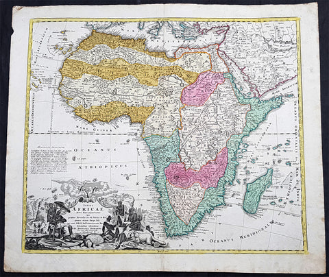
- Title : Totius Africae Nova Repraesentatio qua praeter diversos in ea Status et Regiones, etiam Origo Nili ex veris RRPP Missionariorum Relationibus ostenditur Johann Baptist Homann
- Ref #: 93502
- Size: 25in x 21 1/2in (635mm x 545mm)
- Date : 1715
- Condition: (A+) Fine Condition
Description:
This large original hand coloured copper plate engraved antique 1st edition map of Africa by Johann Baptist Homann was published in 1715.
Handsome, large map of the continent with the typical inaccuracies of eighteenth century cartography. The map conforms to the twin lake configuration for the source of the Nile and a lengthy paragraph on the map purports to provide evidence of the accuracy of this theory based on the work of Heinrich Scherer. The geographical features are identical to the map that Johann engraved for Jacob von Sandrart, circa 1697, prior to Homann establishing his own publishing firm. The political boundaries and the large title cartouche are different. The cartouche is filled with interesting imagery including the pyramids, the source of the Nile, a troop of monkeys (throwing rocks at their hunters), kings, chiefs and warriors, a fat-tailed sheep with its tail supported by a wagon, and cherubs bringing salvation to the continent.
General Definitions:
Paper thickness and quality: - Heavy and stable
Paper color : - off white
Age of map color: - Original
Colors used: - Yellow, green, blue, pink
General color appearance: - Authentic
Paper size: - 25in x 21 1/2in (635mm x 545mm)
Plate size: - 22 1/2in x 19in (565mm x 490mm)
Margins: - Min 1in (25mm)
Imperfections:
Margins: - None
Plate area: - None
Verso: - None
Background:
Being part of the Mediterranean world, the northern coasts of the African continent as far as the Straits of Gibraltar and even round to the area of the Fortunate Isles (the Canaries) were reasonably well known and quite accurately mapped from ancient times. In particular, Egypt and the Nile Valley were well defined and the Nile itself was, of course, one of the rivers separating the continents in medieval T-O maps. Through Arab traders the shape of the east coast, down the Red Sea as far as the equator, was also known but detail shown in the interior faded into deserts with occasional mountain ranges and mythical rivers. The southern part of the continent, in the Ptolemaic tradition, was assumed to curve to the east to form a land-locked Indian Ocean. The voyages of the Portuguese, organized by Henry the Navigator in the fifteenth century, completely changed the picture and by the end of the century Vasco da Gama had rounded the Cape enabling cartographers to draw a quite presentable coastal outline of the whole continent, even if the interior was to remain largely unknown for the next two or three centuries.
The first separately printed map of Africa (as with the other known continents) appeared in Munster\\\'s Geographia from 1540 onwards and the first atlas devoted to Africa only was published in 1588 in Venice by Livio Sanuto, but the finest individual map of the century was that engraved on 8 sheets by Gastaldi, published in Venice in 1564. Apart from maps in sixteenth-century atlases generally there were also magnificent marine maps of 1596 by Jan van Linschoten (engraved by van Langrens) of the southern half of the continent with highly imaginative and decorative detail in the interior. In the next century there were many attractive maps including those of Mercator/Hondius (1606), Speed (1627), Blaeu (1 630), Visscher (1636), de Wit (c. 1670), all embellished with vignettes of harbours and principal towns and bordered with elaborate and colourful figures of their inhabitants, but the interior remained uncharted with the exception of that part of the continent known as Ethiopia, the name which was applied to a wide area including present-day Abyssinia. Here the legends of Prester John lingered on and, as so often happened in other remote parts of the world, the only certain knowledge of the region was provided by Jesuit missionaries. Among these was Father Geronimo Lobo (1595-1678), whose work A Voyage to Abyssinia was used as the basis for a remarkably accurate map published by a German scholar, Hiob Ludolf in 1683. Despite the formidable problems which faced them, the French cartographers G. Delisle (c. 1700-22), J. B. B. d\\\'Anville (1727-49) and N. Bellin (1754) greatly improved the standards of mapping of the continent, improvements which were usually, although not always, maintained by Homann, Seutter, de Ia Rochette, Bowen, Faden and many others in the later years of the century. (Ref: Tooley; M&B)
1720 Homann Large Antique Map of The Islands of Malta - Gozo, Comino, Valletta
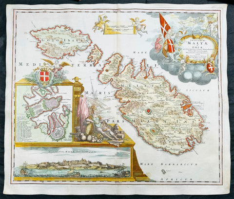
- Title : Insularum Maltae et Gozae quae sunt Equitum S. Ioannis Hierosolimitani Ordinis Melit. Sed
- Date : 1720
- Size: 24in x 20 1/2in (610mm x 520mm)
- Condition: (A+) Fine Condition
- Ref: 43169
Description:
This large beautifully hand coloured original copper plate engraved antique map of the Mediterranean Islands of Malta, Gozo and Comino by J B Homann was published in 1720.
This is one of the best examples of this map I have seen to date. The paper is heavy and clean, original colouring is fresh and beautifully applied with original margins.
General Definitions:
Paper thickness and quality: - Heavy and stable
Paper color : - off white
Age of map color: - Original
Colors used: - Yellow, green, blue, pink
General color appearance: - Authentic
Paper size: - 24in x 20 1/2in (610mm x 520mm)
Plate size: - 23in x 19 1/2in (590mm x 500mm)
Margins: - Min 1/2in (12mm)
Imperfections:
Margins: - None
Plate area: - None
Verso: - None
Background:
One of the most superbly embellished and desirable maps of Malta. Homann's magnificent map of Malta, includes detailed topographical information and many place names. The elaborate title cartouche depicts the knights of Malta in prayer before an image of the crucified Christ. At lower left is a panorama of Valetta from the sea and a further inset map of Valletta with a key of buildings and sites. To the right of the insets is a second elaborate embellishment comprising the Maltese coat of arms and the figure of a Knight of Malta Collections (Ref: Tooley; M&B)
Please note all items auctioned are genuine, we do not sell reproductions. A Certificate of Authenticity (COA) can be issued on request.
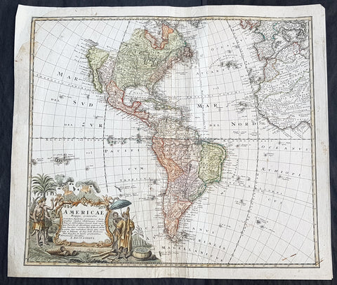
1720 Johannes Baptist Homann Large Antique Map of America
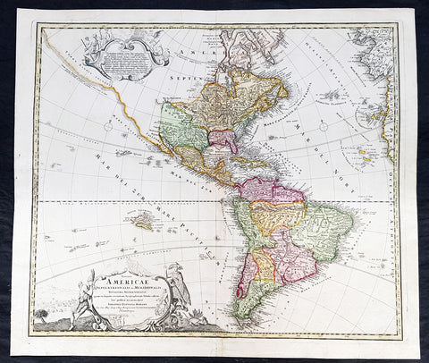
- Title : Totius Americae Septentrionalis et Meridionalis Novissima Representatio quam ex fingulis Geographorum Tabulis collecta luci publicae accommodavit...Johannes Baptista Homann
- Ref #: 93506
- Size: 24in x 21in (610mm x 525mm)
- Date : 1720
- Condition: (A+) Fine Condition
Description:
This large original beautifully hand coloured copper plate antique map of America was published by Johann Baptist Homann in 1720.
A very nice example of this early landmark American map by one of the greats of 17th & 18th century German cartography.
General Definitions:
Paper thickness and quality: - Heavy and stable
Paper color : - off white
Age of map color: - Original
Colors used: - Blue, pink, red, green, yellow
General color appearance: - Authentic
Paper size: - 24in x 21in (610mm x 525mm)
Plate size: - 22 1/2in x 19in (565mm x 490mm)
Margins: - Min 1in (25mm)
Imperfections:
Margins: - None
Plate area: - None
Verso: - Bottom centerfold rejoined at bottom of map, not affecting the image
Background:
This is the second state of Homanns map of America that includes an elongated northwest Coastline is called Costa Terrae Borealis incognitae detecta a Dom: Ioanne de Gama navigante ex China in Novam Hispaniam. The map provides credit for the discovery of this coastline to João de Gama (1540-1591). João da Gama, the grandson of Vasco da Gama, was a Portuguese explorer and colonial administrator in the Far East, during the last quarter of the 16th century. Da Gama sailed from Macau to the northeast and rounded Japan by north, crossing the Pacific Ocean at the northernmost latitudes. The lands northeast of Japan, which João da Gama discovered, were the subject of legend and speculation in the centuries that followed, inspiring its search by European powers.
Good detail throughout the map, especially in the southwest and near the Great Lakes, which were then actively being explored by the French fur traders and Hudson\'s Bay Company.
1746 Homann Large Antique Map of America
- Title : Americae Mappa generalis
- Size: 23in x 20in (595mm x 510mm)
- Condition: (B) Good Condition
- Date : 1746
- Ref #: 93345
Description:
Large original hand coloured antique map of America by the Homann Heirs, in 1746 (dated) published on the cusp of great change in North America in the mid to late 18th century.
General Definitions:
Paper thickness and quality: - Heavy and stable
Paper color : - off white
Age of map color: - Original & later
Colors used: - Blue, pink, red, green, yellow
General color appearance: - Authentic
Paper size: - 23in x 20in (595mm x 510mm)
Plate size: - 22in x 19in (500mm x 470mm)
Margins: - Min 1/2in (12mm)
Imperfections:
Margins: - Top left margin & border corner restored
Plate area: - Age toning, centerfold re-joined with light creasing
Verso: - Centerfold re-joined with light creasing
Background:
Homanns second map of America, which reflects the substantial new information obtained since the issuance of the first map of America by the patriarch of the Homann Family, Johann Baptiste Homann. The decorative cartouche includes some very lively visual imagery, including volcanos and a nice alegorical scene representing the people, flora and fauna of America.
The interior of North America benefits from the knowledge obtained by the Jesuits in the Interior parts of North America, especially along the Mississippi River and English and Dutch information along the coast. The French are still the dominant force in the North, the Spanish in the South, immediately prior to the French and Indian War. The Great Lakes are only just now being accurately charted by D\'Anville and later Mitchell. The west coast conforms to the French updates provided by De L\'Isle and progeny. South America is substantially corrected from earlier models.
The NW Coast of America and NW Passage are still unknown, but wishfully shown. Quivira is shown considerably east of its normal location. Quivira was the the legendary land of gold and silver. Francisco de Coronado began his search for Quivira in 1541, but found only Indian Villages. He did however report to the Spanish King that the land was suitable for growing all of the products of Spain. Quivira migrated progressively further North and East, until it disappeared in the late 18th Century. The map seems to be influenced primarily by the highly influential map of America by De L\'Isle first issued in 1700, although the Haas retains some of the great mythical cartographic features in the interior regions.
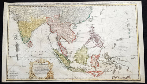
1748 Homann Large Antique Map of Australia, Indonesia, China, SE Asia, India
- Title : Carte Des Indes Orientalis...1748
- Ref #: 93411
- Size: 36 1/4in x 21 1/4in (920mm x 540mm)
- Date : 1748
- Condition: (A+) Fine Condition
Description:
This very large original hand coloured copper plate engraved antique map map of India, SE Asia, The East Indies, Philippines, New Guinea & Australia was engraved by Sebastian Dorn in 1748, dated, and published by the Homann firm.
General Definitions:
Paper thickness and quality: - Light and stable
Paper color : - off white
Age of map color: - Original
Colors used: - Yellow, green, blue, pink
General color appearance: - Authentic
Paper size: - 36 1/4in x 21 1/4in (920mm x 540mm)
Plate size: - 35 1/2in x 20 1/2in (900mm x 515mm)
Margins: - Min 1/2in (12mm)
Imperfections:
Margins: - Light soiling
Plate area: - None
Verso: - Light soiling
Background:
The map is based upon the sea charts created by Jean-Batiste de Mannevillette (1707-80), for the first edition of his Le Neptune Oriental, the first sea atlas of Asian Waters. Mannevillette apprenticed under the great royal cartographer Guillaume De L\'Isle. He then joined the maritime service of the Compagnie des Indes, eventually attaining the rank of captain. Upon his return to Paris, Mannevillette was appointed as director of the Dépôt des Cartes et Plans de la Navigation des Indes.
In 1745, Manneveillette published the first edition of his sea atlas of Asian waters, Le Neptune Oriental. The high quality of Mannevillette\'s charts won him the acclaim of both mariners and academics alike, and he was admitted as a fellow of the Academy of Sciences. He published a second, heavily revised, edition of the Neptune Oriental in 1775.
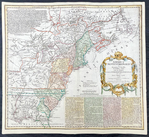
1756 Homann Antique Map Colonial United States North America French Indian War
- Title : America Septentrionalis a domino d Anville in Galiis edita nunc in Anglia coloniis in interiorem Virginiam deductis nec non fluvii Ohio cursu aucta notisq geographicis et historicis illustrata.....1756
- Ref #: 17001
- Size: 21in x 19in (535mm x 480mm)
- Date : 1756
- Condition: (A) Very Good Condition
Description:
This original hand coloured copper-plate engraved antique 1st edition map of the Colonial United States, at the beginning of the French-Indian war, was engraved in 1756 - dated in cartouche - by the Homann firm, Germany.
First edition Homann map of the English Colonies in North America prior to the start of the French and Indian War. The map stretches just west of the Mississippi River to the east and from James Bay through the Great Lakes to the Gulf of Mexico. Although most of the text is in German, there is also much in English, including numerous place named annotations associated the French and Indian War, such as the locations of Fort Duquesne and Fort Necessity, both taken by the French in 1754. Thus although the cartographer credits D Anville for the basic cartography, it is clear he is drawing from English, not French, sources. Bottom right and upper left are notes offering the history of North America.
General Definitions:
Paper thickness and quality: - Heavy and stable
Paper color : - off white
Age of map color: - Original & later
Colors used: - Yellow, green, blue, pink
General color appearance: - Authentic
Paper size: - 21in x 19in (535mm x 480mm)
Plate size: - 21in x 19in (535mm x 480mm)
Margins: - Min 1/2in (12mm)
Imperfections:
Margins: - All margins extended from border
Plate area: - Light crease adjacent to centerfold, soiling in top right border
Verso: - Light soiling.
Background:
The French and Indian War (1754–63) comprised the North American theatre of the worldwide Seven Years War of 1756–63. It pitted the colonies of British America against those of New France. Both sides were supported by military units from their parent countries, as well as by American Indian allies. At the start of the war, the French North American colonies had a population of roughly 60,000 settlers, compared with 2 million in the British North American colonies. The outnumbered French particularly depended on the Indians. The European nations declared war on one another in 1756 following months of localized conflict, escalating the war from a regional affair into an intercontinental conflict.
The name French and Indian War is used mainly in the United States. It refers to the two enemies of the British colonists, the royal French forces and their various American Indian allies. The British colonists were supported at various times by the Iroquois, Catawba, and Cherokee, and the French colonists were supported by Wabanaki Confederacy members Abenaki and Mikmaq, and Algonquin, Lenape, Ojibwa, Ottawa, Shawnee, and Wyandot.
British and other European historians use the term the Seven Years War, as do English-speaking Canadians. French Canadians call it La guerre de la Conquête (the War of the Conquest) or (rarely) the Fourth Intercolonial War.
Fighting took place primarily along the frontiers between New France and the British colonies, from Virginia in the south to Newfoundland in the north. It began with a dispute over control of the confluence of the Allegheny River and Monongahela River called the Forks of the Ohio, and the site of the French Fort Duquesne in Pittsburgh, Pennsylvania. The dispute erupted into violence in the Battle of Jumonville Glen in May 1754, during which Virginia militiamen under the command of 22-year-old George Washington ambushed a French patrol.
In 1755, six colonial governors in North America met with General Edward Braddock, the newly arrived British Army commander, and planned a four-way attack on the French. None succeeded, and the main effort by Braddock proved a disaster; he lost the Battle of the Monongahela on July 9, 1755 and died a few days later. British operations failed in the frontier areas of Pennsylvania and New York during 1755–57 due to a combination of poor management, internal divisions, effective Canadian scouts, French regular forces, and Indian warrior allies. In 1755, the British captured Fort Beauséjour on the border separating Nova Scotia from Acadia, and they ordered the expulsion of the Acadians (1755–64) soon afterwards. Orders for the deportation were given by William Shirley, Commander-in-Chief, North America, without direction from Great Britain. The Acadians were expelled, both those captured in arms and those who had sworn the loyalty oath to His Britannic Majesty. Indians likewise were driven off the land to make way for settlers from New England.
The British colonial government fell in the region of modern Nova Scotia after several disastrous campaigns in 1757, including a failed expedition against Louisbourg and the Siege of Fort William Henry; this last was followed by Indians torturing and massacring their British victims. William Pitt came to power and significantly increased British military resources in the colonies at a time when France was unwilling to risk large convoys to aid the limited forces that they had in New France, preferring to concentrate their forces against Prussia and its allies in the European theater of the war. Between 1758 and 1760, the British military launched a campaign to capture the Colony of Canada (part of New France). They succeeded in capturing territory in surrounding colonies and ultimately the city of Quebec (1759). The British later lost the Battle of Sainte-Foy west of Quebec (1760), but the French ceded Canada in accordance with the Treaty of Paris (1763).
The outcome was one of the most significant developments in a century of Anglo-French conflict. France ceded to Great Britain its territory east of the Mississippi. It ceded French Louisiana west of the Mississippi River (including New Orleans) to its ally Spain in compensation for Spains loss to Britain of Florida. (Spain had ceded Florida to Britain in exchange for the return of Havana, Cuba.) Frances colonial presence north of the Caribbean was reduced to the islands of Saint Pierre and Miquelon, confirming Great Britains position as the dominant colonial power in eastern North America.
Please note all items auctioned are genuine, we do not sell reproductions. A Certificate of Authenticity (COA) can be issued on request.
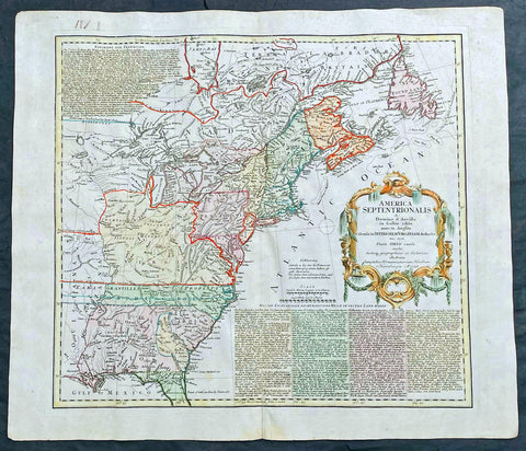
1756 Homann Antique Map Colonial United States North America French Indian War
- Title : America Septentrionalis a domino d Anville in Galiis edita nunc in Anglia coloniis in interiorem Virginiam deductis nec non fluvii Ohio cursu aucta notisq geographicis et historicis illustrata.....1756
- Ref #: 27018
- Size: 24in x 21in (610mm x 535mm)
- Date : 1756
- Condition: (A) Very Good Condition
Description:
This original hand coloured copper-plate engraved antique 1st edition map of the Colonial United States, at the beginning of the French-Indian war, was engraved in 1756 - dated in cartouche - by the Homann firm, Germany.
This map has original margins and colour on heavy clean sturdy paper.
First edition Homann map of the English Colonies in North America prior to the start of the French and Indian War. The map stretches just west of the Mississippi River to the east and from James Bay through the Great Lakes to the Gulf of Mexico. Although most of the text is in German, there is also much in English, including numerous place named annotations associated the French and Indian War, such as the locations of Fort Duquesne and Fort Necessity, both taken by the French in 1754. Thus although the cartographer credits D Anville for the basic cartography, it is clear he is drawing from English, not French, sources. Bottom right and upper left are notes offering the history of North America.
General Definitions:
Paper thickness and quality: - Heavy and stable
Paper color : - off white
Age of map color: - Original & later
Colors used: - Yellow, green, blue, pink
General color appearance: - Authentic
Paper size: - 24in x 21in (610mm x 535mm)
Plate size: - 21in x 19in (535mm x 480mm)
Margins: - Min 1/2in (12mm)
Imperfections:
Margins: - Light staining in lower margins, bottom margin centerfold rejoined with transparent archival tape
Plate area: - Light age toning along centerfold
Verso: - None
Background:
The French and Indian War (1754–63) comprised the North American theatre of the worldwide Seven Years War of 1756–63. It pitted the colonies of British America against those of New France. Both sides were supported by military units from their parent countries, as well as by American Indian allies. At the start of the war, the French North American colonies had a population of roughly 60,000 settlers, compared with 2 million in the British North American colonies. The outnumbered French particularly depended on the Indians. The European nations declared war on one another in 1756 following months of localized conflict, escalating the war from a regional affair into an intercontinental conflict.
The name French and Indian War is used mainly in the United States. It refers to the two enemies of the British colonists, the royal French forces and their various American Indian allies. The British colonists were supported at various times by the Iroquois, Catawba, and Cherokee, and the French colonists were supported by Wabanaki Confederacy members Abenaki and Mikmaq, and Algonquin, Lenape, Ojibwa, Ottawa, Shawnee, and Wyandot.
British and other European historians use the term the Seven Years War, as do English-speaking Canadians. French Canadians call it La guerre de la Conquête (the War of the Conquest) or (rarely) the Fourth Intercolonial War.
Fighting took place primarily along the frontiers between New France and the British colonies, from Virginia in the south to Newfoundland in the north. It began with a dispute over control of the confluence of the Allegheny River and Monongahela River called the Forks of the Ohio, and the site of the French Fort Duquesne in Pittsburgh, Pennsylvania. The dispute erupted into violence in the Battle of Jumonville Glen in May 1754, during which Virginia militiamen under the command of 22-year-old George Washington ambushed a French patrol.
In 1755, six colonial governors in North America met with General Edward Braddock, the newly arrived British Army commander, and planned a four-way attack on the French. None succeeded, and the main effort by Braddock proved a disaster; he lost the Battle of the Monongahela on July 9, 1755 and died a few days later. British operations failed in the frontier areas of Pennsylvania and New York during 1755–57 due to a combination of poor management, internal divisions, effective Canadian scouts, French regular forces, and Indian warrior allies. In 1755, the British captured Fort Beauséjour on the border separating Nova Scotia from Acadia, and they ordered the expulsion of the Acadians (1755–64) soon afterwards. Orders for the deportation were given by William Shirley, Commander-in-Chief, North America, without direction from Great Britain. The Acadians were expelled, both those captured in arms and those who had sworn the loyalty oath to His Britannic Majesty. Indians likewise were driven off the land to make way for settlers from New England.
The British colonial government fell in the region of modern Nova Scotia after several disastrous campaigns in 1757, including a failed expedition against Louisbourg and the Siege of Fort William Henry; this last was followed by Indians torturing and massacring their British victims. William Pitt came to power and significantly increased British military resources in the colonies at a time when France was unwilling to risk large convoys to aid the limited forces that they had in New France, preferring to concentrate their forces against Prussia and its allies in the European theater of the war. Between 1758 and 1760, the British military launched a campaign to capture the Colony of Canada (part of New France). They succeeded in capturing territory in surrounding colonies and ultimately the city of Quebec (1759). The British later lost the Battle of Sainte-Foy west of Quebec (1760), but the French ceded Canada in accordance with the Treaty of Paris (1763).
The outcome was one of the most significant developments in a century of Anglo-French conflict. France ceded to Great Britain its territory east of the Mississippi. It ceded French Louisiana west of the Mississippi River (including New Orleans) to its ally Spain in compensation for Spains loss to Britain of Florida. (Spain had ceded Florida to Britain in exchange for the return of Havana, Cuba.) Frances colonial presence north of the Caribbean was reduced to the islands of Saint Pierre and Miquelon, confirming Great Britains position as the dominant colonial power in eastern North America.
Please note all items auctioned are genuine, we do not sell reproductions. A Certificate of Authenticity (COA) can be issued on request.
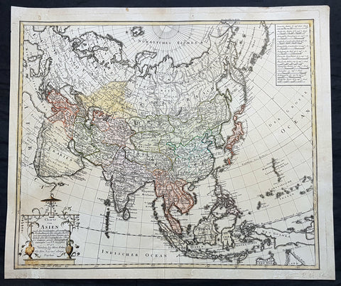
1793 Gussefeld & Homann Antique Map of Asia New Holland to China to Saudi Arabia
- Title : Charte von Asien....F L Gusfeld 1793 Nurnberg bey Hom. Erben
- Ref #: 93410
- Size: 24 1/4in x 20 1/2in (615mm x 520mm)
- Date : 1793
- Condition: (A) Very Good Condition
Description:
This large, important & scarce hand coloured original copper-plate engraved antique map of Asia by Franz Ludwig Gussefeld (1744 – 1807) in 1793 - dated - was published by the famous German cartography firm of The Homann Heirs.
General Definitions:
Paper thickness and quality: - Heavy and stable
Paper color : - off white
Age of map color: - Original
Colors used: - Yellow, green, blue, pink
General color appearance: - Authentic
Paper size: - 24 1/4in x 20 1/2in (615mm x 520mm)
Plate size: - 23 1/2in x 19 1/2in (595mm x 495mm)
Margins: - Min 1/2in (12mm)
Imperfections:
Margins: - Light soiling
Plate area: - Small repair to bottom left corner & cartouche
Verso: - Bottom left repair as mentioned
Background:
Franz Ludwig Gussefeld (1744 –1807) was a German cartographer noted for his highly accurate & detailed maps, most of which were published by Homannsche Erben (Homann Heirs) firm in Nuremberg, Germany in the 18th century.
Gussefeld was born in Osterberg and at an early age had an interest in drawing and creating maps. His first map of the German state of Brandenburg was published in 1773 and was the first of over a 100 of his maps published by the Homann firm. The high quality of Gussefeld\\\'s work is credited with saving the Homann Heirs firm, a famous publishing house that had come under financial difficulties after the death of the founder JB Homann.
Gussefeld died of pulmonary edema in Weimar in 1807. (Ref: Tooley; M&B)