Henry Teesdale
1834 Henry Teesdale Antique Map The Pacific, Australia, New Zealand, Nth America
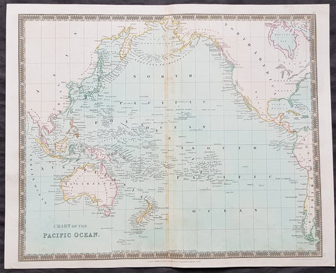
- Title : Chart of The Pacific Ocean.....London Published by Henry Teesdale & co. High Holborn March 1834
- Ref #: 50303
- Size: 17 1/2in x 14in (445mm x 355mm)
- Date : 1834
- Condition: (A+) Fine Condition
Description:
This beautifully hand coloured original copper-plate engraved antique map of the Pacific Ocean, Australia, New Zealand, to North & South America by John Dower was engraved in 1834 - the date is engraved at the foot of the map - and was published in the 1835 edition of Henry Teesdales A New General Atlas of the World. (Ref: M&B; Tooley)
General Definitions:
Paper thickness and quality: - Heavy and stable
Paper color : - off white
Age of map color: - Original
Colors used: - Yellow, green, blue, pink
General color appearance: - Authentic
Paper size: - 19in x 15 1/2in (485mm x 395mm)
Plate size: - 17 1/2in x 14 1/2in (445mm x 370mm)
Margins: - Min 1in (25mm)
Imperfections:
Margins: - None
Plate area: - None
Verso: - None
Teesdale & co., Henry fl 1828-1843
Teesdale was a prominent London publisher and founding fellow of the Royal Geographical Society. He produced large-scale maps and charts and a number of fine atlases in the early part of the nineteenth century. He employed the most skilled draftsmen and engravers and his maps are renowned for precise detail and fine coloring
1834 Henry Teesdale Large Antique Map Switzerland divided in Cantons - Beautiful
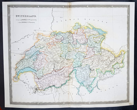
- Title : 1834 Henry Teesdale Large Antique Map Switzerland divided in Cantons - Beautiful
- Date : 1834
- Condition: (A+) Fine Condition
- Ref: 50286
- Size: 17in x 14in (430mm x 355mm)
Description:
This beautifully hand coloured original steel-plate engraved antique map of Switzerland was engraved by John Dower in 1834 - dated at the foot of the map - and was published in the 1835 edition of Henry Teesdale\'s A New General Atlas of the World.
As with all the maps published by Teesdale this one is of the highest quality on strong clean & sturdy paper with beautiful original hand colouring. (Ref: M&B; Tooley)
General Definitions:
Paper thickness and quality: - Heavy and stable
Paper color : - off white
Age of map color: - Original
Colors used: - Blue, red, yellow, green
General color appearance: - Authentic
Paper size: - 17in x 14in (430mm x 355mm)
Plate size: - 17in x 14in (430mm x 355mm)
Margins: - Min 1/2in (12mm)
Imperfections:
Margins: - None
Plate area: - None
Verso: - None
Background:
The establishment of the Old Swiss Confederacy dates to the late medieval period, resulting from a series of military successes against Austria and Burgundy. Swiss independence from the Holy Roman Empire was formally recognized in the Peace of Westphalia in 1648. The country has a history of armed neutrality going back to the Reformation; it has not been in a state of war internationally since 1815 and did not join the United Nations until 2002. Nevertheless, it pursues an active foreign policy and is frequently involved in peace-building processes around the world. In addition to being the birthplace of the Red Cross, Switzerland is home to numerous international organisations, including the second largest UN office. On the European level, it is a founding member of the European Free Trade Association, but notably not part of the European Union, the European Economic Area or the Eurozone. However, it participates in the Schengen Area and the European Single Market through bilateral treaties.
Spanning the intersection of Germanic and Romance Europe, Switzerland comprises four main linguistic and cultural regions: German, French, Italian and Romansh. Although the majority of the population are German speaking, Swiss national identity is rooted in a common historical background, shared values such as federalism and direct democracy, and Alpine symbolism. Due to its linguistic diversity, Switzerland is known by a variety of native names: Schweiz, Suisse, Svizzera and Svizra. On coins and stamps, the Latin name – frequently shortened to Helvetia – is used instead of the four national languages.
Teesdale & co., Henry fl 1828-1843
Teesdale was a prominent London publisher and founding fellow of the Royal Geographical Society. He produced large-scale maps and charts and a number of fine atlases in the early part of the nineteenth century. He employed the most skilled draftsmen and engravers and his maps are renowned for precise detail and fine coloring
1835 Henry Teesdale Large Antique Map of Van Diemens Land, Tasmania, Australia
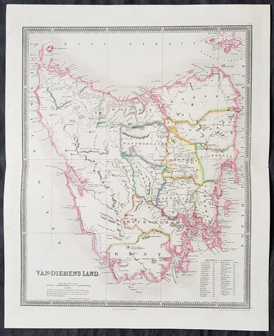
- Title : Van-Diemens Land
- Ref #: 80010
- Size: 19in x 15 1/2in (485mm x 395mm)
- Date : 1834
- Condition: (A+) Fine Condition
Description:
This fine beautifully hand coloured original antique map of Tasmania, Van-Diemens Land with the original 11 counties - was engraved by John Dower in 1834 and was published in the 1835 edition of Henry Teesdale's A New General Atlas of the World.
As with all the maps published by Teesdale this one is of the highest quality on strong clean & sturdy paper with beautiful original hand colouring. (Ref: M&B; Tooley)
General Definitions:
Paper thickness and quality: - Heavy and stable
Paper color : - off white
Age of map color: - Original
Colors used: - Yellow, green, blue, pink
General color appearance: - Authentic
Paper size: - 19in x 15 1/2in (485mm x 395mm)
Plate size: - 17 1/2in x 14 1/2in (445mm x 370mm)
Margins: - Min 1in (25mm)
Imperfections:
Margins: - None
Plate area: - None
Verso: - None
Background:
The first reported sighting of Tasmania by a European was on 24 November 1642 by the Dutch explorer Abel Tasman, who named the island Anthoonij van Diemenslandt, after his sponsor, the Governor of the Dutch East Indies. The name was later shortened to Van Diemen's Land by the British. In 1772, a French expedition led by Marc-Joseph Marion du Fresne landed on the island. Captain James Cook also sighted the island in 1777, and numerous other European seafarers made landfalls, adding a colourful array to the names of topographical features.
The first settlement was by the British at Risdon Cove on the eastern bank of the Derwent estuary in 1803, by a small party sent from Sydney, under Lt. John Bowen. An alternative settlement was established by Capt. David Collins 5 km to the south in 1804 in Sullivans Cove on the western side of the Derwent, where fresh water was more plentiful. The latter settlement became known as Hobart Town, later shortened to Hobart, after the British Colonial Secretary of the time, Lord Hobart. The settlement at Risdon was later abandoned.
Teesdale & co., Henry fl 1828-1843
Teesdale was a prominent London publisher and founding fellow of the Royal Geographical Society. He produced large-scale maps and charts and a number of fine atlases in the early part of the nineteenth century. He employed the most skilled draftsmen and engravers and his maps are renowned for precise detail and fine coloring