Gerald Mercator
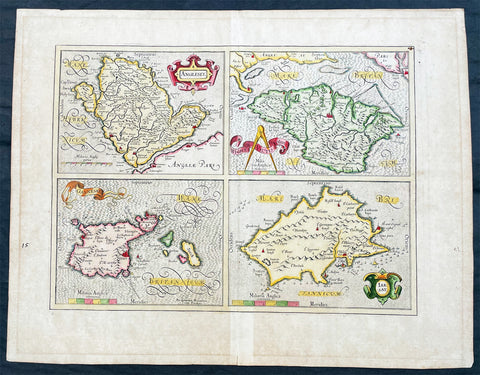
1606 Gerard Mercator Antique Map British Islands Anglesey, Wight Guernsey Jersey
- Title : Anglesey; Wight Vectis, olim; Garnesay: Jarsay
- Ref #: 17014
- Size: 21 1/2in x 17in (550mm x 430mm)
- Date : 1606
- Condition: (A+) Fine Condition
Description:
This beautifully hand coloured original copper plate engraved antique map of the 4 British Islands of Anglesey, Wight Guernsey Jersey by Gerard Mercator was published by Henricus Hondius in the 1606 edition of Mercators Atlas, Atlas Sive Cosmographicae Meditationes Illustrissimi Ducis.
This map is beautiful with early original hand colour, heavy dark impression, on heavy paper and original margins.
General Definitions:
Paper thickness and quality: - Heavy and stable
Paper color : - off white
Age of map color: - Early
Colors used: - Yellow, green, blue, pink
General color appearance: - Authentic
Paper size: - 21 1/2in x 17in (550mm x 430mm)
Plate size: - 17 1/4in x 12 1/2in (440mm x 315mm)
Margins: - Min 2in (50mm)
Imperfections:
Margins: - Age toning in margins
Plate area: - None
Verso: - Age Toning
Anglesey is an island off the north-west coast of Wales. The English name of the island may be derived from the Old Norse; either Ǫngullsey Hook Island or Ǫnglisey Ǫngli's Island. No record of such an Ǫngli survives, but the place name was used by Viking raiders as early as the 10th century and later adopted by the Normans during their invasions of Gwynedd. The traditional folk etymology reading the name as the Island of the Angles (English)] may account for its Norman use but has no merit, as the Angles name itself is probably cognate with the shape of the Angeln peninsula. All of them ultimately derive from the proposed Proto-Indo-European root *ank- (to flex, bend, angle). Throughout the 18th and 19th centuries and into the 20th, it was usually spelt Anglesea in documents.
The oldest records that give a name for the Isle of Wight are from the Roman Empire: it was then called Vectis or Vecta in Latin, Iktis or Ouiktis in Greek. From the Anglo-Saxon period Latin Vecta, Old English Wiht and Old Welsh forms Gueid and Guith are recorded. In Domesday Book it is Wit; the modern Welsh name is Ynys Wyth (ynys = island). These are all variant forms of the same name, possibly Celtic in origin. It may mean "place of the division", because the island divides the two arms of the Solent.
The Channel Islands are an archipelago of British Crown Dependencies in the English Channel, off the French coast of Normandy. They include two separate bailiwicks: the Bailiwick of Jersey and the Bailiwick of Guernsey. They are considered the remnants of the Duchy of Normandy, and are not part of the United Kingdom. They have a total population of about 168,000 and their respective capitals, Saint Helier and Saint Peter Port, have populations of 33,500 and 16,488, respectively. The total area of the islands is 194 km.
Both Bailiwicks have been administered separately since the late 13th century; each has its own independent laws, elections, and representative bodies (although in modern times, politicians from the islands' legislatures are in regular contact). Any institution common to both is the exception rather than the rule.
Please note all items auctioned are genuine, we do not sell reproductions. A Certificate of Authenticity (COA) can be issued on request.
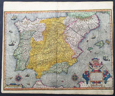
1607 Mercator Antique Map of Spain & Portugal
- Title : Hispania Nova Descriptio de Integro...Petrus Kaerius
- Date : 1607
- Condition: (A) Very Good Condition
- Ref: 42002
- Size: 20in x 18in (510mm x 430mm)
Description:
This fine beautifully hand coloured original antique map of Spain & Portugal by Gerard Mercator was published by Rumold Mercator &Jodocus Hondius in the very early 1607 Latin edition of Mercators Atlas.
This map is magnificent with beautiful original hand colouring. Original colouring such as this is scarce and hard to find.
These maps, published in the early editions of Mercators atlas, are the original maps drawn and engraved by Gerald Mercator in the mid to late 16th century, published by his son Rumold as an atlas, after his death, in 1595. After two editions the plates were purchased by Jodocus Hondius in 1604 and continued to be published until the mid 1630's when the plates were re-engraved and updated by Jan Jansson and Henricus Hondius.
Background:
Many of the original charts and maps drawn by the first Portuguese and Spanish navigators have survived for the very good reason that, on completion of their voyages, pilots were obliged to hand over their manuscript notes to the Casa da India (founded 1504) in Lisbon or to the equivalent Casa de Contrataci6n de las Indias (founded 1504) in Seville. The clear intention was to maintain secrecy over new discoveries and control over the distribution of cartographic material, not always successfully, as it happened; pilots and navigators seem to have changed allegiance with impunity and, in consequence, many of the earliest and most informative charts were compiled as far away as Genoa, Venice, Florence and Ancona, presumably from sources outside the Portuguese and Spanish 'Casas'.It is apparent that few manuscripts reached the printing stage and, indeed, are so rare that any study of them must be regarded as a specialist subject. (Ref Tooley M&B)(Ref: Koeman; Tooley)
Condition Report:
Paper thickness and quality: - Heavy and stable
Paper color: - off white
Age of map color: - Original
Colors used: - Yellow, red, green, purple, blue
General color appearance: - Authentic
Paper size: - 20in x 18in (510mm x 430mm)
Plate size: - 20in x 16in (420mm x 380mm)
Margins: - Min 0in (0mm)
Imperfections:
Margins: - Left margin cropped into border
Plate area: - Light creasing along centerfold
Verso: - Light re-enforcing along centerfold
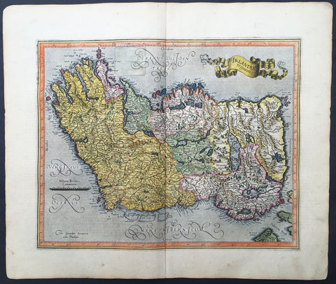
1607 Mercator Hondius Original Antique Map of Ireland - Rare and beautiful
- Title : Irlandiae regnum
- Date : 1607
- Condition: (A) Very Good Condition
- Ref: 42003
- Size: 20in x 18in (560mm x 430mm)
Description:
This fine beautifully hand coloured original antique map of Ireland by Gerald Mercator was published by Rumold Mercator & Jodocus Hondius in the very early 1607 Latin edition of Mercators Atlas.
This map is magnificent with beautiful original hand colouring. Original colouring such as this is scarce and hard to find.
These maps, published in the early editions of Mercators atlas, are the original maps drawn and engraved by Gerald Mercator in the mid to late 16th century, published by his sons Rumold & Henricus as an atlas, after his death, in 1595. After two editions the plates were purchased by Jodocus Hondius in 1604 and continued to be published until the mid 1630's when the plates were re-engraved and updated by Jan Jansson and Henricus Hondius.
The earliest maps of Ireland up to the year 1500 or so share the shortcomings of those of the rest of the British Isles especially as represented on world maps. It was not to be expected that lands literally on the very edge of the known world could be depicted with any accuracy; very often one feels that the cartographers or engravers placed the islands in the nearest available space consistent with their imagined position. Even in the first printed Ptolemaic map there is still much distortion in Ireland's shape and geographical position but, on the other hand, a quite surprising number of place names and other details are shown, as many, in fact, as in the rest of Britain put together. This detailed knowledge is not as puzzling as it might appear, for the Ptolemy maps, at least the later editions from 1513 onwards, were based on Italian portulan charts and these, in turn, reflected knowledge gained during the long commercial relationship which had existed between Italy and Ireland ever since the thirteenth century. The distortions on land-surveyed maps remained uncorrected until late in the seventeenth century but a quite accurate coastal outline was given in the marine atlases of Waghenaer, Dudley, Blaeu and later Dutch chart makers.
Apart from a few manuscript maps and very rare maps printed in Rome and Venice (George Lily, 1546, and others in the period 1560-66) Ireland is shown on Mercator's large map of the British Isles (1564), and in his Atlas (1595) and as a separate sheet in the Ortelius atlases (from 1 573). The most important map, however, was compiled by an Italian, Baptista Boazio, probably in the 1 5 8os. This has survived in manuscript form and may have been used by Pieter van der Keere for a map published by Jodocus Hondius in 1591. Boazio's map was subsequently published by John Sudbury, who later sold Speed's maps, and this version was included in editions of the Ortelius atlases from 6oz onwards. The Boazio map is a quite splendid map, very decorative, some copies even showing an Eskimo complete with kayak and hunting spear. Thereafter the trend is familiar: Camden, Speed, Blaeu, Jansson, Sanson and others of the Dutch and French schools all included a general map or maps of the Irish provinces in their atlases. Speed's map of the whole of Ireland was based at least partly on surveys by Robert Lythe (c.1570) and Francis Jobson(c.1590) and included figures in national costume; it was for long regarded as the best map available and was much copied by publishers in other countries.
In 1685 the first atlas of Ireland to match Saxton's At/as of Eng/andand Wales was published by Sir William Petty as Hiberniae Detineaho, the result of a highly organized and detailed survey (the 'Down' survey) carried out in the years following 1655. Re-issued in miniature form soon afterwards by Francis Lamb, Petty's Atlas was widely used as the basis for practically all maps of Ireland produced by English, French, Dutch and German publishers in the following century. Apart from re-issues of Petty's Atlas and its many copyists there were maps by George Grierson, a Dublin publisher, John Rocque, the Huguenot surveyor and engraver who spent some years in Dublin, and Bernard Scale, Rocque's brother-in-law.
Towards the end of the century many large-scale maps were published but, as in England, private mapping was gradually overtaken and eventually replaced by the Ordnance Survey maps produced between the years 1824 and 1846.(Ref: Koeman, Tooley)
Condition Report:
Paper thickness and quality: - Heavy and stable
Paper color: - off white
Age of map color: - Original
Colors used: - Yellow, red, green, purple, blue
General color appearance: - Authentic
Paper size: - 20in x 18in (560mm x 430mm)
Plate size: - 17 1/2in x 14in (420mm x 330mm)
Margins: - Min 1in (25mm)
Imperfections:
Margins: - Light age toning to margins
Plate area: - Old professional repair to 45mm sq to left side
Verso: - Old professional repair to text "H"
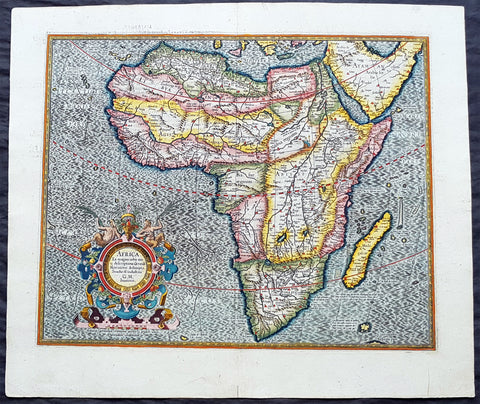
1613 Gerard Mercator Large Antique Map of Africa - Africa Ex Magna
- Title : Africa Ex Magna orbis terra descriptione Gerardi Mercatoris desumpta. Studio & industria GM Iunioris
- Size: 22in x 18 3/4in (560mm x 475mm)
- Condition: (A+) Fine Condition
- Date : 1613
- Ref #: 34173
Description:
This beautifully hand coloured original antique map of Africa by Gerard Mercator was published by Henricus Hondius in the 1613 French edition of Mercators Atlas, Atlas Sive Cosmographicae Meditationes Illustrissimi Ducis.
This map is exceptional with original hand colour, heavy dark impression, clean heavy paper and original margins.
As indicated in the title Cartouche, this map this is a reduction by Gerard Mercator Junior of Africa, compiled from Gerard Mercator\'s world map of 1569. This rendition was drawn by Mercator\'s grandson (also named Gerard) in 1595.
The map is typical of 16th century cartography of Africa containing some fantastical detail especially in regards to the interior. The depiction of the Nile is based on Ptolemys geography with some complex modifications from various sources, including Abyssinian monks. The source of the Nile is shown as a series of lakes located in the Lune Montes just north of the Tropic of Capricorn. Another branch of the Nile flows from the west, with this system rambling through what is the Sahara Desert. Mercator adds a lake named Sac. Haf lac, from the 1507 Waldseemuller world map. This lake feeds both the Zambere River and the Nile. In Abissini, the legendary Christian King Prester John sits on his throne. The boldly engraved oceans, beautiful calligraphy, and strapwork cartouche (surmounted by two satyrs) make this a decorative masterpiece.
General Definitions:
Paper thickness and quality: - Heavy and stable
Paper color : - off white
Age of map color: - Original
Colors used: - Yellow, green, blue, pink
General color appearance: - Authentic
Paper size: - 22in x 18 3/4in (560mm x 475mm)
Plate size: - 18 1/2in x 15in (470mm x 380mm)
Margins: - Min 1in (25mm)
Imperfections:
Margins: - None
Plate area: - None
Verso: - None
Background:
Being part of the Mediterranean world, the northern coasts of the African continent as far as the Straits of Gibraltar and even round to the area of the Fortunate Isles (the Canaries) were reasonably well known and quite accurately mapped from ancient times. In particular, Egypt and the Nile Valley were well defined and the Nile itself was, of course, one of the rivers separating the continents in medieval T-O maps. Through Arab traders the shape of the east coast, down the Red Sea as far as the equator, was also known but detail shown in the interior faded into deserts with occasional mountain ranges and mythical rivers. The southern part of the continent, in the Ptolemaic tradition, was assumed to curve to the east to form a land-locked Indian Ocean. The voyages of the Portuguese, organized by Henry the Navigator in the fifteenth century, completely changed the picture and by the end of the century Vasco da Gama had rounded the Cape enabling cartographers to draw a quite presentable coastal outline of the whole continent, even if the interior was to remain largely unknown for the next two or three centuries.
The first separately printed map of Africa (as with the other known continents) appeared in Munster\'s Geographia from 1540 onwards and the first atlas devoted to Africa only was published in 1588 in Venice by Livio Sanuto, but the finest individual map of the century was that engraved on 8 sheets by Gastaldi, published in Venice in 1564. Apart from maps in sixteenth-century atlases generally there were also magnificent marine maps of 1596 by Jan van Linschoten (engraved by van Langrens) of the southern half of the continent with highly imaginative and decorative detail in the interior. In the next century there were many attractive maps including those of Mercator/Hondius (1606), Speed (1627), Blaeu (1 630), Visscher (1636), de Wit (c. 1670), all embellished with vignettes of harbours and principal towns and bordered with elaborate and colourful figures of their inhabitants, but the interior remained uncharted with the exception of that part of the continent known as Ethiopia, the name which was applied to a wide area including present-day Abyssinia. Here the legends of Prester John lingered on and, as so often happened in other remote parts of the world, the only certain knowledge of the region was provided by Jesuit missionaries. Among these was Father Geronimo Lobo (1595-1678), whose work A Voyage to Abyssinia was used as the basis for a remarkably accurate map published by a German scholar, Hiob Ludolf in 1683. Despite the formidable problems which faced them, the French cartographers G. Delisle (c. 1700-22), J. B. B. d\'Anville (1727-49) and N. Bellin (1754) greatly improved the standards of mapping of the continent, improvements which were usually, although not always, maintained by Homann, Seutter, de Ia Rochette, Bowen, Faden and many others in the later years of the century.

1613 Mercator Antique Map of America & The Great Southern Land - Terra Australis
- Title : America sive India Nova. ad magna Gerardi Mercatoris aui Universalis imitationem in compendium redacta. Per Michaelem Mercatorem Duysburgensem
- Ref #: 61033
- Size: 20 1/2in x 17 1/2in (510mm x 445mm)
- Date : 1613
- Condition: (A+) Fine Condition
Description:
This fine beautifully hand coloured original antique early map of America and the Great Southern Continent (Terra Australis) that was envisaged in the southern Hemisphere, prior to the discovery of Australia by Captain Cook in 1769 - the only map attributed to Gerard Mercator's Grandson Michael - was published in the 1633 French edition of Mercator's Atlas.
This map is magnificent with beautiful original hand colouring, wide margins and stable paper. Backed with transparent archival Japanese paper. Original colouring such as this is scarce and hard to find.
Condition Report:
Paper thickness and quality: - Heavy and stable
Paper color: - off white
Age of map color: - Original
Colors used: - Yellow, red, green, orange, blue
General color appearance: - Authentic
Paper size: - 21 1/2in x 17 3/4in (545mm x 450mm)
Plate size: - 18 1/2in x 14 3/4in (470mm x 376mm)
Margins: - Min 1in (25mm)
Imperfections:
Margins: - Light soiling in margins
Plate area: - None
Verso: - None
Background: Largely based on Rumold Mercator's world map of 1587, this map aptly reflects 16th-century knowledge, theories and suppositions regarding the New World. Naturally, most of this new knowledge was coastal, and configurations of any large areas were greatly hampered by the lack of a sound means of determining longitude. Nevertheless, the collective accomplishment of explorers and mapmakers represented in this map is astounding, showing in a generally correct way the vast extent of the New World. "A few of the most famous theories are still present: a large inland lake in Canada, two of the four islands of the North Pole, a bulge to the west coast of South America and the large southern continent" (Burden).
The map appeared in 1595 and 1606 editions of the Atlantis Pars Altera , after which the plate was sold to Jodocus Hondius, who reissued the maps in varying editions through 1639. The present example includes French text on verso, confirming it to be a Hondius issue.
Several of the more fascinating theories are present, including the multiple islands of the North Polar Sea, bulging South America and vast unknown southern continent. The St. Lawrence crosses half the continent. No sign of the English in Virginia. The search for a water course across North America is interupted only by some mid-continental mountains. Evidence of the Spanish explorations in the Southwest is present and the Colorado and Gila Rivers already reflect a good knowledge of this area, as does the peninsular Baja California, based upon Uloa's work.
The depiction of the NW Passage and Western North America are also of great interest. Annotations reference the voyages of Columbus and Magellan.(Ref: Burden; Koeman; Tooley; M&B)
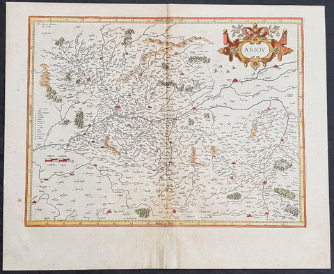
1628 Henricus Hondius Antique Map of the Duchy of Anjou, Maine-et-Loire, France
- Title : Aniov
- Date : 1628
- Size: 21in x 17in (535mm x 430mm)
- Ref #: 26135
- Condition: (A) Very Good Condition
Description:
This beautifully hand coloured original copper-plate engraved antique map of the French region of the historical province of Anjou (today a greater part of the Maine-et-Loire dept.) centering on the city of Angers & the Loire River was published in the 1628 French edition of Mercators Atlas by Henricus Hondius and Jan Jansson.
General Definitions:
Paper thickness and quality: - Heavy and stable
Paper color : - off white
Age of map color: - Original
Colors used: - Yellow, green, blue, pink
General color appearance: - Authentic
Paper size: - 21in x 17in (535mm x 430mm)
Plate size: - 18in x 14in (460mm x 360mm)
Margins: - Min 1/2in (12mm)
Imperfections:
Margins: - None
Plate area: - Age toning along centerfold
Verso: - Age toning along centerfold
Background:
Anjou is a historical province of France straddling the lower Loire River. Its capital was Angers and it was roughly coextensive with the diocese of Angers. It bordered Brittany to the west, Maine to the north, Touraine to the east and Poitou to the south. The adjectival form of Anjou is Angevin and inhabitants of Anjou are known as Angevins. During the Middle Ages, the county of Anjou was a prominent fief of the French crown.
The region takes its name from the Celtic tribe of the Andecavi, who submitted to Roman rule following the Gallic Wars. Under the Romans, the chief fortified settlement of the Andecavi became the city of Juliomagus, the future Angers. The territory of the Andecavi was organized as a civitas (called the civitas Andegavensis or civitas Andegavorum).
Under the Franks, the city of Juliomagus took the name of the ancient tribe and became Angers. Under the Merovingians, the history of Anjou is obscure. It is not recorded as a county (comitatus) until the time of the Carolingians. In the late ninth and early tenth centuries the viscounts (representatives of the counts) usurped comital authority and made Anjou an autonomous hereditary principality. The first dynasty of counts of Anjou, the House of Ingelger, ruled continuously down to 1205. In 1131, Count Fulk V became the King of Jerusalem; then in 1154, his grandson, Henry \'Curtmantle\' became King of England. The territories ruled by Henry and his successors, which stretched from Ireland to the Pyrenees, are often called the Angevin Empire. This empire was broken up by the French king Philip II, who confiscated the dynasty\'s French lands, including Anjou in 1205.
The county of Anjou was united to the royal domain between 1205 and 1246, when it was turned into an apanage for the king\'s brother, Charles I of Anjou. This second Angevin dynasty, a branch of the Capetian dynasty, established itself on the throne of Naples and Hungary. Anjou itself was united to the royal domain again in 1328, but was detached in 1360 as the Duchy of Anjou for the king\'s son, Louis I of Anjou. The third Angevin dynasty, a branch of the House of Valois, also ruled for a time the Kingdom of Naples. The dukes had the same autonomy as the earlier counts, but the duchy was increasingly administered in the same fashion as the royal domain and the royal government often exercised the ducal power while the dukes were away. When the Valois line failed and Anjou was incorporated into the royal domain again in 1480, there was little change on the ground. Anjou remained a province of crown until the French Revolution (1790), when the provinces were reorganized.

1633 Mercator Antique Map of America & The Great Southern Land - Terra Australis
- Title : America sive India Nova. ad magna Gerardi Mercatoris aui Universalis imitationem in compendium redacta. Per Michaelem Mercatorem Duysburgensem
- Ref #: 61017
- Size: 21 1/2in x 17 3/4in (545mm x 450mm)
- Date : 1633
- Condition: (A) Very Good Condition
Description:
This fine beautifully hand coloured original antique early map of America and the Great Southern Continent (Terra Australis) that was envisaged in the southern Hemisphere, prior to the discovery of Australia by Captain Cook in 1769 - the only map attributed to Gerard Mercator's Grandson Michael - was published in the 1633 French edition of Mercator's Atlas.
This map is magnificent with beautiful original hand colouring, wide margins and stable paper. Backed with transparent archival Japanese paper. Original colouring such as this is scarce and hard to find.
Condition Report:
Paper thickness and quality: - Heavy and stable
Paper color: - off white
Age of map color: - Original
Colors used: - Yellow, red, green, orange, blue
General color appearance: - Authentic
Paper size: - 21 1/2in x 17 3/4in (545mm x 450mm)
Plate size: - 18 1/2in x 14 3/4in (470mm x 376mm)
Margins: - Min 1in (25mm)
Imperfections:
Margins: - Uniform age toning
Plate area: - Uniform age toning, light creasing & uplift along center-fold
Verso: - Backed with transparent archival Japanese paper
Background: Largely based on Rumold Mercator's world map of 1587, this map aptly reflects 16th-century knowledge, theories and suppositions regarding the New World. Naturally, most of this new knowledge was coastal, and configurations of any large areas were greatly hampered by the lack of a sound means of determining longitude. Nevertheless, the collective accomplishment of explorers and mapmakers represented in this map is astounding, showing in a generally correct way the vast extent of the New World. "A few of the most famous theories are still present: a large inland lake in Canada, two of the four islands of the North Pole, a bulge to the west coast of South America and the large southern continent" (Burden).
The map appeared in 1595 and 1606 editions of the Atlantis Pars Altera , after which the plate was sold to Jodocus Hondius, who reissued the maps in varying editions through 1639. The present example includes French text on verso, confirming it to be a Hondius issue.
Several of the more fascinating theories are present, including the multiple islands of the North Polar Sea, bulging South America and vast unknown southern continent. The St. Lawrence crosses half the continent. No sign of the English in Virginia. The search for a water course across North America is interupted only by some mid-continental mountains. Evidence of the Spanish explorations in the Southwest is present and the Colorado and Gila Rivers already reflect a good knowledge of this area, as does the peninsular Baja California, based upon Uloa's work.
The depiction of the NW Passage and Western North America are also of great interest. Annotations reference the voyages of Columbus and Magellan.(Ref: Burden; Koeman; Tooley; M&B)
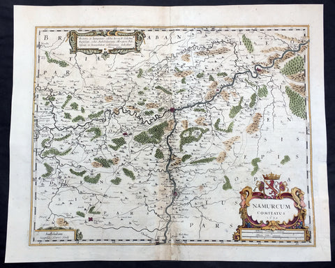
1636 Mercator Hondius Large Antique Map of Namur Region of Belgium, Huy & Meuse
- Title : Namurcum Comitatus 1632
- Date : 1636
- Size: 22in x 18in (570mm x 470mm)
- Ref #: 41622
- Condition: (A) Very Good Condition
Description:
This beautifully hand coloured original antique map of the Belgium region of Namur - centering on the cities of Namur, Huy, Dinant and the Meuse River - was engraved in 1632 by Henricus Hondius - dated - and was published in the rare 1636 English edition of Mercator's Atlas, by Henricus Hondius and Jan Jansson.
As there were so few of these atlases published with English text on the verso that maps from them are now understandably scarce.
Background: Namur is a province of Wallonia, one of the three regions of Belgium. It borders (clockwise from the West) on the Walloon provinces of Hainaut, Walloon Brabant, Liège and Luxembourg in Belgium, and on France. Its capital is the city of Namur.
The text running for two pages on the verso of this map describes the region or country name, history (as it was), temperature, seasons, soil and agricultural productivity. Also described is the topography, wildlife, local inhabitants their culture and religion, as well as a description of major European and local towns and cities. This text makes extremely enjoyable reading and a very good insight not only into the area described but the general European attitudes towards alien countries and cultures. (Ref: Koeman; M&B; Tooley)
Condition Report:
Paper thickness and quality: - Heavy and stable
Paper color: - off white
Age of map color: - Original
Colors used: - Yellow, pink, green
General color appearance: - Authentic
Paper size: - 22in x 18in (570mm x 470mm)
Plate size: - 19 1/2in x 15in (500mm x 380mm)
Margins: - Min 1in (25mm)
Imperfections:
Margins: - Left margin repaired
Plate area: - Centrefold re-joined with small loss to bottom border
Verso: - Centerfold re-joined, colour bleed through.