Edward Weller
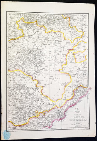
1857 Edward Weller Large Antique Map of Hyderabad & Nagpur Regions of India
- Title : India Nagpoor, Hyderabad
- Ref #: 70490
- Size: 18in x 13in (470mm x 330mm)
- Date : 1857
- Condition: (A+) Fine Condition
Description:
This original lithograph hand coloured antique map by Edward Weller was engraved by Day & Co. and was published in the 1857 edition of The Dispatch Atlas; a compilation of maps Weller had already published in The Weekly Dispatch.
General Definitions:
Paper thickness and quality: - Heavy and stable
Paper color : - off white
Age of map color: - Original
Colors used: - Yellow, Green, pink
General color appearance: - Authentic
Paper size: - 18in x 13in (470mm x 330mm)
Plate size: - 18in x 13in (470mm x 330mm)
Margins: - Min 1/2in (10mm)
Imperfections:
Margins: - None
Plate area: - None
Verso: - None
Edward Weller 1819 - 1884; was a London-based engraver, cartographer and publisher, working from offices in Red Lion Square and later, Bloomsbury. Amongst his considerable portfolio were various atlases, many of which focussed on the educational publishing market. Having established his credentials as an engraver of finely detailed works, he sold maps to be published in a number of regular magazines and pamphlets, perhaps the best known being The Dispatch Atlas; a compilation of maps Weller had already published in The Weekly Dispatch. Although Weller usually engraved the maps himself, he did work in partnership with others, particularly John Dower for this 1858 and 1863 volume. Weller also published The Crown Atlas in 1871.
The Dispatch Atlas featured well over one hundred superbly detailed steel plate engraved maps, usually with simplistic, single colour outline hand colouring, and a distinctive header style. Most English counties featured, some of which were divided onto separate sheets, affording space to engrave in even greater detail. The maps of North and South Devonshire for example include such details as individual property names, as do those of the Northern and Southern parts of Hampshire.
After Wellers death in 1884, many of these astonishingly detailed plates were sold on to other map makers, including George Washington Bacon, who, whilst retaining the level of detail, expanded the printing area of each plate, adding more precise and varied hand colouring in keeping with the final decades of the century.
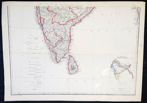
1857 Edward Weller Large Antique Map of Southern India & Sri Lanka, Ceylon
- Title : India (South Part)
- Ref #: 40996
- Size: 18in x 13in (470mm x 330mm)
- Date : 1857
- Condition: (A+) Fine Condition
Description:
This original lithograph hand coloured antique map by Edward Weller was engraved by Day & Co. and was published in the 1857 edition of The Dispatch Atlas; a compilation of maps Weller had already published in The Weekly Dispatch.
General Definitions:
Paper thickness and quality: - Heavy and stable
Paper color : - off white
Age of map color: - Original
Colors used: - Yellow, Green, pink
General color appearance: - Authentic
Paper size: - 18in x 13in (470mm x 330mm)
Plate size: - 18in x 13in (470mm x 330mm)
Margins: - Min 1/2in (10mm)
Imperfections:
Margins: - None
Plate area: - None
Verso: - None
Weller, Edward 1819 – 1884
Weller was a London-based engraver, cartographer and publisher, working from offices in Red Lion Square and later, Bloomsbury. Amongst his considerable portfolio were various atlases, many of which focussed on the educational publishing market. Having established his credentials as an engraver of finely detailed works, he sold maps to be published in a number of regular magazines and pamphlets, perhaps the best known being The Dispatch Atlas; a compilation of maps Weller had already published in The Weekly Dispatch. Although Weller usually engraved the maps himself, he did work in partnership with others, particularly John Dower for this 1858 and 1863 volume. Weller also published The Crown Atlas in 1871.
The Dispatch Atlas featured well over one hundred superbly detailed steel plate engraved maps, usually with simplistic, single colour outline hand colouring, and a distinctive header style. Most English counties featured, some of which were divided onto separate sheets, affording space to engrave in even greater detail. The maps of North and South Devonshire for example include such details as individual property names, as do those of the Northern and Southern parts of Hampshire.
After Wellers death in 1884, many of these astonishingly detailed plates were sold on to other map makers, including George Washington Bacon, who, whilst retaining the level of detail, expanded the printing area of each plate, adding more precise and varied hand colouring in keeping with the final decades of the century.
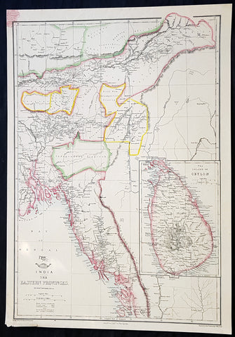
1858 Edward Weller Large Antique Map of Bangladesh, Assam, Sri lanka Ceylon
- Title : India The Eastern Provinces by Edward Weller
- Ref #: 70495
- Size: 18in x 13in (470mm x 330mm)
- Date : 1858
- Condition: (A+) Fine Condition
Description:
This original lithograph hand coloured antique map by Edward Weller was engraved by Day & Co. and was published in the 1858 edition of The Dispatch Atlas; a compilation of maps Weller had already published in The Weekly Dispatch.
General Definitions:
Paper thickness and quality: - Heavy and stable
Paper color : - off white
Age of map color: - Original
Colors used: - Yellow, Green, pink
General color appearance: - Authentic
Paper size: - 18in x 13in (470mm x 330mm)
Plate size: - 18in x 13in (470mm x 330mm)
Margins: - Min 1/2in (10mm)
Imperfections:
Margins: - None
Plate area: - None
Verso: - None
Weller, Edward 1819 – 1884
Weller was a London-based engraver, cartographer and publisher, working from offices in Red Lion Square and later, Bloomsbury. Amongst his considerable portfolio were various atlases, many of which focussed on the educational publishing market. Having established his credentials as an engraver of finely detailed works, he sold maps to be published in a number of regular magazines and pamphlets, perhaps the best known being The Dispatch Atlas; a compilation of maps Weller had already published in The Weekly Dispatch. Although Weller usually engraved the maps himself, he did work in partnership with others, particularly John Dower for this 1858 and 1863 volume. Weller also published The Crown Atlas in 1871.
The Dispatch Atlas featured well over one hundred superbly detailed steel plate engraved maps, usually with simplistic, single colour outline hand colouring, and a distinctive header style. Most English counties featured, some of which were divided onto separate sheets, affording space to engrave in even greater detail. The maps of North and South Devonshire for example include such details as individual property names, as do those of the Northern and Southern parts of Hampshire.
After Wellers death in 1884, many of these astonishingly detailed plates were sold on to other map makers, including George Washington Bacon, who, whilst retaining the level of detail, expanded the printing area of each plate, adding more precise and varied hand colouring in keeping with the final decades of the century.
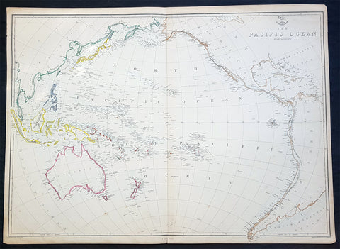
1860 Edward Weller Large Antique Map of The Pacific - Australia to California
- Title : The Pacific Ocean
- Ref #: 70063
- Size: 26 1/2in x 19in (675mm x 490mm)
- Date : 1860
- Condition: (A+) Fine Condition
Description:
This original steel plate engraved hand coloured antique map by Edward Weller was published in the 1860 edition of The Dispatch Atlas; a compilation of maps Weller had already published in The Weekly Dispatch.
General Definitions:
Paper thickness and quality: - Heavy and stable
Paper color : - off white
Age of map color: - Original
Colors used: - Yellow, Green, pink
General color appearance: - Authentic
Paper size: - 26 1/2in x 19in (675mm x 490mm)
Plate size: - 26 1/2in x 19in (675mm x 490mm)
Margins: - Min 1/2in (10mm)
Imperfections:
Margins: - None
Plate area: - None
Verso: - None
Weller, Edward 1819 – 1884
Weller was a London-based engraver, cartographer and publisher, working from offices in Red Lion Square and later, Bloomsbury. Amongst his considerable portfolio were various atlases, many of which focussed on the educational publishing market. Having established his credentials as an engraver of finely detailed works, he sold maps to be published in a number of regular magazines and pamphlets, perhaps the best known being The Dispatch Atlas; a compilation of maps Weller had already published in The Weekly Dispatch. Although Weller usually engraved the maps himself, he did work in partnership with others, particularly John Dower for this 1858 and 1863 volume. Weller also published The Crown Atlas in 1871.
The Dispatch Atlas featured well over one hundred superbly detailed steel plate engraved maps, usually with simplistic, single colour outline hand colouring, and a distinctive header style. Most English counties featured, some of which were divided onto separate sheets, affording space to engrave in even greater detail. The maps of North and South Devonshire for example include such details as individual property names, as do those of the Northern and Southern parts of Hampshire.
After Wellers death in 1884, many of these astonishingly detailed plates were sold on to other map makers, including George Washington Bacon, who, whilst retaining the level of detail, expanded the printing area of each plate, adding more precise and varied hand colouring in keeping with the final decades of the century.
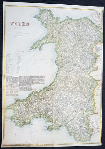
1878 Edward Weller Large Antique Map of Wales
- Title : Wales by Edward Weller FRGS
- Size: 34 1/2in x 24 1/2in (880m x 620mm)
- Condition: (A) Very Good Condition
- Date : 1878
- Ref #: 70570
Description:
This very large original hand coloured steel plate engraved antique map of Wales by Edward Weller was published by Cassell, Petter & Galpin.
General Definitions:
Paper thickness and quality: - Heavy and stable
Paper color : - off white
Age of map color: - Original
Colors used: - Yellow, green, blue, pink
General color appearance: - Authentic
Paper size: - 34 1/2in x 24 1/2in (880m x 620mm)
Plate size: - 34 1/2in x 24 1/2in (880m x 620mm)
Margins: - Min 1/2in (12mm)
Imperfections:
Margins: - Light soiling
Plate area: - 13in repair to bottom left sheet, no loss
Verso: - Repair as noted
Background:
Cassell & Co is a British book publishing house, founded in 1848 by John Cassell (1817–1865), which became in the 1890s an international publishing group company.
John Cassell (1817–1865), who was in turn a carpenter, temperance preacher, tea and coffee merchant, finally turned to publishing. His first publication was on 1 July 1848, a weekly newspaper called The Standard of Freedomadvocating religious, political, and commercial freedom. The Working Man\\\\\\\'s Friend became another popular publication. In 1849 Cassell was dividing his time between his publishing and his grocery business. In 1851 his expanding interests led to his renting part of La Belle Sauvage, a London inn which had been a playhouse in Elizabethan times. The former inn was demolished in 1873 to make way for a railway viaduct, with the company building new premises behind. La Belle Sauvage was destroyed in 1941 by WWII bombing as well as many archives.
Thomas Dixon Galpin who came from Dorchester in Dorset and George William Petter who was born in Barnstaplein Devon were partners in a printing firm and on John Cassell\\\\\\\'s bankruptcy in June 1855 acquired the publishing company and Cassell\\\\\\\'s debts. Between 1855 and 1858 the printing firm operated as Petter and Galpin and their work was published by W. Kent & Co.
John Cassell was relegated to being a junior partner after becoming insolvent in 1858, the firm being known as Cassell, Petter & Galpin. With the arrival of a new partner, Robert Turner, in 1878, it became Cassell, Petter, Galpin & Company. Galpin was the astute business manager. George Lock, the founder of Ward Lock, another publishing house, was Galpin\\\\\\\'s first cousin. Petter resigned in 1883 as a result of disagreement over publishing fiction, and in 1888 the company name was changed to Cassell & Co, Ltd, following Galpin\\\\\\\'s retirement and Petters death.
Weller, Edward 1819 – 1884
Weller was a British engraver and cartographer who was one of the first to produce maps using lithography. He was a London-based working from offices in Red Lion Square and later, Bloomsbury.