Cornelis van Wytfliet

1597 Cornelis Wytfliet Antique Map Early Important Map of Australia, South America Terra Australis
- Title : Chica Sive Patagonica et Australis Terra
- Size: 15in x 12in (380mm x 305mm)
- Condition: (A+) Fine Condition
- Date : 1597
- Ref #: 41718
Description:
A fine original antique, and incredibly important map of Patagonia & the Magellan Straits but more importantly one of the first maps to depict a distinctive outline of Australia - depicted here as part of Terra Australis the Great Southern Land - and was published by Cornelis van Wytfliet in the 1597 edition of Descriptionis Ptolemaicae Augmentum.
Wytfliets famous map of the southern continent from the first atlas of the Americas, Descriptionis Ptolemaicae Augmentum, sive Occidentis Notitia in 1597.
In the top part of the map, Patagonia is separated by a strait from a large southern continent named Australis Terrae Pars. The naming of C. Della Victoria and the illustration of Magellans ship, Victoria, indicates, although not names on the map, as the Strait of Magellan. The lower portion of the map is a polar projection, showing Terra Australis as the large landmass made up of four peninsulas, one reaching towards New Guinea which is shown as an island. This and the other peninsula to the west is one of the earliest and clearest indications of cartographical knowledge of Northern Australia, specifically Northern Queensland, the Gulf of Carpentaria & parts of the Northern Territory.
Gunter Schilder discusses this map at length and points to its significance to Major Collingridge and others as proof that Australia had already been discovered in the sixteenth century....
Wytfliet notes The Australis Terra is the most southern of all lands; it is separated from New Guinea by a narrow strait; its shores are hitherto but little known, since, after one voyage and another, that route has been deserted, and seldom is the country visited unless when sailors are driven there by storms. The Australis Terra begins at two or three degrees from the equator, and is maintained by some to be of so great an extent that if it were thoroughly explored it would be regarded as a fifth part of the world.
Wyfliets depiction of a narrow strait separating Australis Terra from New Guinea, predates that of Torress discovery in 1606. Torress passage was not known to the world until the end of the 18th century, when Dalrymple discovered Torress journal of the voyage amongst archives in Manila.
General Definitions:
Paper thickness and quality: - Heavy and stable
Paper color : - off white
Age of map color: -
Colors used: -
General color appearance: -
Paper size: - 15in x 12in (380mm x 305mm)
Plate size: - 11 1/4in x 9 1/4in (285mm x 235mm)
Margins: - Min 1in (25mm)
Imperfections:
Margins: - None
Plate area: - None
Verso: - None
Background:
In 1597 Cornelis van Wytfliet published his Augmentum to Ptolemys Geography. Dedicated to Philip III of Spain it is a history of the New World to date, recording its discovery, natural history etc. For the book Wytfliet had engraved nineteen maps, by whom we do not know, one of the world and eighteen regional maps of the Americas. As such this book can be truly called the first atlas of the New World, America.
Wytfliet, Cornelis van d. 1597
Cornelius Wytfliet or Cornelis van Wytfliet was a geographer from Leuven in the Habsburg Netherlands, best known for producing the first atlas of the Americas.
Cornelius was the son of Catherine Huybrechts and her husband, Gregorius Wytfliet, who was advocate fiscal of Leuven University from 1557 to 1594. After graduating Licentiate in Laws from the University of Leuven, Wytfliet moved to Brussels and became secretary to the Council of Brabant. He died in or shortly after 1597, when his Descriptionis Ptolemaicae Augmentum (a work adding new discoveries to Ptolemy\\\'s description of the world) was published
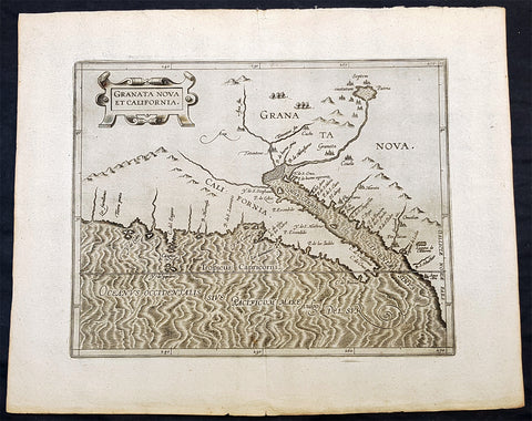
1597 Cornelis Wytfliet Antique Map Early Important Map of California & SW America
- Title : Granata Nova et California
- Size: 15in x 12in (380mm x 305mm)
- Condition: (A+) Fine Condition
- Date : 1597
- Ref #: 41716
Description:
A fine original antique, and incredibly important map the first to focus on California & the SW was published by Cornelis van Wytfliet in the 1597 edition of Descriptionis Ptolemaicae Augmentum.
The first printed map devoted to California and the south-west of the present day United States. One of the most interesting features is the depiction of so many fabled places largely from Spanish sources. Most notable amongst these are the seven cities of Cibola. The seven cities originated from the narrative of Fray Marcos de Niza in 1539. Some of the other nomenclature originates from Coronados epic exploration. The outline map is fairly accurate and is derived largely from Petrus Plancius large world map of 1592. The main coastal irregularity is the westward slant of the Californian coastline. Bearing in mind that it would be shown as part of an island in twenty five years, this is quite forgivable. No other states of the map are known and all issues are without text on the back (Burden 106).
General Definitions:
Paper thickness and quality: - Heavy and stable
Paper color : - off white
Age of map color: -
Colors used: -
General color appearance: -
Paper size: - 15in x 12in (380mm x 305mm)
Plate size: - 11 1/4in x 9 1/4in (285mm x 235mm)
Margins: - Min 1in (25mm)
Imperfections:
Margins: - None
Plate area: - None
Verso: - None
Background:
In 1597 Cornelis van Wytfliet published his Augmentum to Ptolemys Geography. Dedicated to Philip III of Spain it is a history of the New World to date, recording its discovery, natural history etc. For the book Wytfliet had engraved nineteen maps, by whom we do not know, one of the world and eighteen regional maps of the Americas. As such this book can be truly called the first atlas of the New World, America.
Wytfliet, Cornelis van d. 1597
Cornelius Wytfliet or Cornelis van Wytfliet was a geographer from Leuven in the Habsburg Netherlands, best known for producing the first atlas of the Americas.
Cornelius was the son of Catherine Huybrechts and her husband, Gregorius Wytfliet, who was advocate fiscal of Leuven University from 1557 to 1594. After graduating Licentiate in Laws from the University of Leuven, Wytfliet moved to Brussels and became secretary to the Council of Brabant. He died in or shortly after 1597, when his Descriptionis Ptolemaicae Augmentum (a work adding new discoveries to Ptolemys description of the world) was published
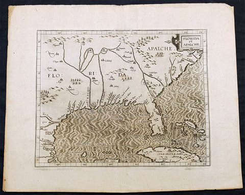
1597 Cornelis Wytfliet Early Antique Map of Florida, Louisiana, North America
- Title : Florida et Apalche
- Size: 15in x 12in (380mm x 305mm)
- Condition: (A+) Fine Condition
- Date : 1597
- Ref #: 41717
Description:
A fine original antique, and incredibly important map of the southern United States, one of only 3 maps printed prior to 1600, to depict this area with any accuracy, was published by Cornelis van Wytfliet in the 1597 edition of Descriptionis Ptolemaicae Augmentum. Wytfliet copied information from the Abraham Ortelius 1584 map Geronimo de Chaves map entitled La Florida, augmented with written accounts of Hernando de Soto inland expedition of 1539-42. Wytfliet also expands the area covered south to include parts of Cuba and north to C. de Arenas or the area of the Outer Banks of Carolina. It also enabled him to include the territory called Apalache. As such it is one of the few maps of the sixteenth century to record inland information largely from first hand European sources. Along with the Ortelius map of 1584, and the Johannes Metellus of 1598, these are the only printed maps of the present day southern United States published in the sixteenth century. The Florida peninsula is altered in shape from the Ortelius in that it is more rectangular and has a pronounced neck. The source for this delineation appears to be unknown. The Rio del Spirito Santo shown here is the Mississippi River. As noted by Burden:
The Florida Peninsula is altered in shape from Ortelius, in that it is more rectangular and has a pronounced neck. The source of this delineation appears to be unknown. The Rio del Spirito Santo shown here is the Mississippi River.
The map is known in only one state, but was also copied by Metellus in 1598.
General Definitions:
Paper thickness and quality: - Heavy and stable
Paper color : - off white
Age of map color: -
Colors used: -
General color appearance: -
Paper size: - 15in x 12in (380mm x 305mm)
Plate size: - 11 1/4in x 9 1/4in (285mm x 235mm)
Margins: - Min 1in (25mm)
Imperfections:
Margins: - Small professional repair to top border
Plate area: - None
Verso: - None
Background:
In 1597 Cornelis van Wytfliet published his Augmentum to Ptolemys Geography. Dedicated to Philip III of Spain it is a history of the New World to date, recording its discovery, natural history etc. For the book Wytfliet had engraved nineteen maps, by whom we do not know, one of the world and eighteen regional maps of the Americas. As such this book can be truly called the first atlas of the New World, America.
Wytfliet, Cornelis van d. 1597
Cornelius Wytfliet or Cornelis van Wytfliet was a geographer from Leuven in the Habsburg Netherlands, best known for producing the first atlas of the Americas.
Cornelius was the son of Catherine Huybrechts and her husband, Gregorius Wytfliet, who was advocate fiscal of Leuven University from 1557 to 1594. After graduating Licentiate in Laws from the University of Leuven, Wytfliet moved to Brussels and became secretary to the Council of Brabant. He died in or shortly after 1597, when his Descriptionis Ptolemaicae Augmentum (a work adding new discoveries to Ptolemy\\\'s description of the world) was published