Benjamin Cole
1755 Cole Maitland Large Antique Map, Plan of Cheap Ward London England
- Title : Cheap Ward with its Division into Parishes according to a New Survey
- Ref : 22541
- Size: 20in x 15 1/2in (510mm x 395mm)
- Date : 1755
- Condition: (B) Good Condition
Description:
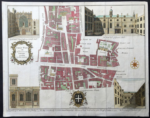
This large fine original antique print & plan of the Cheap Ward, located in central London - stretching from Aldermambury Street in the North to Bow Lane in the South - was engraved by Benjamin Cole - engraver and mapseller - in 1755 - dated at the foot of the map - for Ward Maps of Maitlands History of London.
Background: This is a beautiful map of the Cheap Ward in London, England by Benjamin Cole. The map covers Cheap (from the Old English word meaning 'market') Ward in the City of London from Milk Street east to Prince's Street and from Guildhall south as far as Queen Victoria Street. Cole identifies various important buildings in profile, many of which still exist, including Guildhall, Blackwell Hall, St. Mary le Bow Church, Mercers Chapel, etc. Guildhall, build in 1440, is the only non-Church building that has survived to this day. Once used a town hall, it is still an administrative and ceremonial center on London.
Four illustrated views are included in each quadrant. The top left quadrant features the Guild Hall Chapel adjoining to Guild Hall, the top right quadrant features the South View of Grocer's Hall, the lower right quadrant features the West view of Blackwell Hall and the lower left quadrant includes the South view of St. Mildred's Church in the Poultry. A decorative title cartouche adorns the left of the map while coat of arms of Samuel Fludyer Esqr., to whom this map is dedicated to, appears along the bottom margin with the inscription 'This Plan is most humbly inscribed to Samuel Fludyer Esqr. Alderman of Cheap Ward and one of the Sheriffs of London in 1755.'
This map was derived from earlier plans by John Strype with the illustrations based on West and Tow's 1736 Prospect Views of Ancient Churches. This map was created by Benjamin Cole and issued as part of William Maitland's History of London from its Foundation to the Present Time. (Ref: Tooley; M&B)
General Description:
Paper thickness and quality: - Heavy and stable
Paper color: - off white
Age of map color: - Early
Colors used: - Pink, yellow, green
General color appearance: - Authentic
Paper size: - 20in x 15 1/2in (510mm x 395mm)
Plate size: - 19in x 15in (470mm x 370mm)
Margins: - Min 1/2in (10mm)
Imperfections:
Margins: - Folds as issued, creasing & light soiling along folds
Plate area: - Folds as issued, creasing & light soiling along folds
Verso: - Folds as issued, creasing & light soiling along folds, small repair no loss
1756 Cole Maitland Antique Map, Evelyns Plan For London after Great Fire of 1666
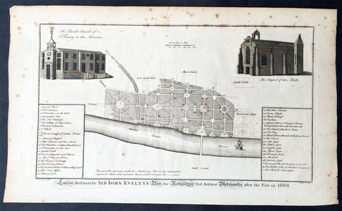
- Title : London Restored or Sir John Evelyns Plan for Rebuilding the Antient Metropolis after the Fire in 1666
- Ref #: 26338
- Size: 16in x 9 1/2in (410mm x 245mm)
- Date : 1756
- Condition: (A) Very Good Condition
Description:
This fine original antique print a plan for the rebuilding of London by Sir John Evelyn after the great Fire Of London in 1666 - was engraved by Benjamin Cole and published in the 1756 edition of The History of London from its Foundation to the Present Time...', by William Maitland, Osborne & Shipton and Hodges, London
Great Fire of London (1666)
The Great Plague was immediately followed by another catastrophe, albeit one which helped to put an end to the plague. On the Sunday, 2 September 1666 the Great Fire of London broke out at one o'clock in the morning at a bakery in Pudding Lane in the southern part of the City. Fanned by an eastern wind the fire spread, and efforts to arrest it by pulling down houses to make firebreaks were disorganised to begin with. On Tuesday night the wind fell somewhat, and on Wednesday the fire slackened. On Thursday it was extinguished, but on the evening of that day the flames again burst forth at the Temple. Some houses were at once blown up by gunpowder, and thus the fire was finally mastered. The Monument was built to commemorate the fire: for over a century and a half it bore an inscription attributing the conflagration to a "popish frenzy"
The fire destroyed about 60% of the City, including Old St Paul's Cathedral, 87 parish churches, 44 livery company halls and the Royal Exchange. However, the number of lives lost was surprisingly small; it is believed to have been 16 at most. Within a few days of the fire, three plans were presented to the king for the rebuilding of the city, by Christopher Wren, John Evelyn and Robert Hooke.
Wren proposed to build main thoroughfares north and south, and east and west, to insulate all the churches in conspicuous positions, to form the most public places into large piazzas, to unite the halls of the 12 chief livery companies into one regular square annexed to the Guildhall, and to make a fine quay on the bank of the river from Blackfriars to the Tower of London. Wren wished to build the new streets straight and in three standard widths of thirty, sixty and ninety feet. Evelyn's plan differed from Wren's chiefly in proposing a street from the church of St Dunstan's in the East to the St Paul's, and in having no quay or terrace along the river. These plans were not implemented, and the rebuilt city generally followed the streetplan of the old one, and most of it has survived into the 21st century.
Nonetheless, the new City was different from the old one. Many aristocratic residents never returned, preferring to take new houses in the West End, where fashionable new districts such as St. James's were built close to the main royal residence, which was Whitehall Palace until it was destroyed by fire in the 1690s, and thereafter St. James's Palace. The rural lane of Piccadilly sprouted courtiers mansions such as Burlington House. Thus the separation between the middle class mercantile City of London, and the aristocratic world of the court in Westminster became complete.
In the City itself there was a move from wooden buildings to stone and brick construction to reduce the risk of fire. Parliament's Rebuilding of London Act 1666 stated "building with brick [is] not only more comely and durable, but also more safe against future perils of fire". From then on only doorcases, window-frames and shop fronts were allowed to be made of wood.
Christopher Wren's plan for a new model London came to nothing, but he was appointed to rebuild the ruined parish churches and to replace St Paul's Cathedral. His domed baroque cathedral was the primary symbol of London for at least a century and a half. As city surveyor, Robert Hooke oversaw the reconstruction of the City's houses. The East End, that is the area immediately to the east of the city walls, also became heavily populated in the decades after the Great Fire. London's docks began to extend downstream, attracting many working people who worked on the docks themselves and in the processing and distributive trades. These people lived in Whitechapel, Wapping, Stepney and Limehouse, generally in slum conditions.
In the winter of 1683–4 a frost fair was held on the Thames. The frost, which began about seven weeks before Christmas and continued for six weeks after, was the greatest on record. The Revocation of the Edict of Nantes in 1685 led to a large migration on Huguenots to London. They established a silk industry at Spitalfields.
At this time the Bank of England was founded, and the British East India Company was expanding its influence. Lloyd's of London also began to operate in the late 17th century. In 1700 London handled 80% of England's imports, 69% of its exports and 86% of its re-exports. Many of the goods were luxuries from the Americas and Asia such as silk, sugar, tea and tobacco. The last figure emphasises London's role as an entrepot: while it had many craftsmen in the 17th century, and would later acquire some large factories, its economic prominence was never based primarily on industry. Instead it was a great trading and redistribution centre. Goods were brought to London by England's increasingly dominant merchant navy, not only to satisfy domestic demand, but also for re-export throughout Europe and beyond.
William III, a Dutchman, cared little for London, the smoke of which gave him asthma, and after the first fire at Whitehall Palace (1691) he purchased Nottingham House and transformed it into Kensington Palace. Kensington was then an insignificant village, but the arrival of the court soon caused it to grow in importance. The palace was rarely favoured by future monarchs, but its construction was another step in the expansion of the bounds of London. During the same reign Greenwich Hospital, then well outside the boundary of London, but now comfortably inside it, was begun; it was the naval complement to the Chelsea Hospital for former soldiers, which had been founded in 1681. During the reign of Queen Anne an act was passed authorising the building of 50 new churches to serve the greatly increased population living outside the boundaries of the City of London. (Ref: Tooley; M&B)
General Description:
Paper thickness and quality: - Heavy and stable
Paper color: - off white
Age of map color: -
Colors used: -
General color appearance: -
Paper size: - 16in x 9 1/2in (410mm x 245mm)
Plate size: - 13 3/4in x 8 1/4in (350mm x 210mm)
Margins: - Min 1in (25mm)
Imperfections:
Margins: - Light spotting in margins
Plate area: - Light spotting
Verso: - Light spotting