Augustus Heinrich Petermann
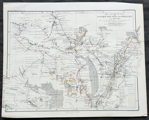
1860 Petermann Antique Map - Tracks of 14 Explorers 1840-59 in South Australia
- Title : Die Entdeckungen Innern Von Sud-Australien von 1840-60...Gotha: Justus Perthes 1860
- 10 1/2in x 8 1/2in (265mm x 215mm)
- Condition: (A+) Fine Condition
- Date : 1860
- Ref #: 82061
Description:
This original antique lithograph map illustrating expeditions around Torrens, Gregory and Gairdner Lakes in South Australia from 1840 to 1859 by Augustus Heinrich Petermann was engraved in 1860 - dated - and was published by Justus Perthes, Gotha Germany.
General Definitions:
Paper thickness and quality: - Heavy and stable
Paper color : - off white
Age of map color: - Original
Colors used: - Red
General color appearance: - Authentic
Paper size: - 10 1/2in x 8 1/2in (265mm x 215mm)
Plate size: - 10 1/2in x 8 1/2in (265mm x 215mm)
Margins: - Min 1/2in (12mm)
Imperfections:
Margins: - None
Plate area: - Folds as issued
Verso: - None
Background:
The tracks of 14 different explorers are covered in this map. They are:
1. Eyre 1840
2. Frome 1843
3. Stuart 1840
4. Hack 1857
5. Millar 1857
6. Goyder 1857 & 60
7. Freeling 1857
8. Harris 1858
9. Babbage 1858
10. Stuart 1858
11. Warburton 1858
12. Parry 1858
13. Gregory 1858
14. Mc Donnell 1859
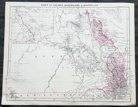
1861 A H Petermann Antique Map of early Queensland, Australia
- Title : Karte der Colonie Queensland in Australien...Gotha Justus: Perthes 1861
- 10 1/2in x 8 1/2in (265mm x 215mm)
- Condition: (A+) Fine Condition
- Date : 1861
- Ref #: 82053
Description:
This early original antique lithograph map of Queensland, Australia, by Augustus Heinrich Petermann was engraved in 1861 - dated - and was published by Justus Perthes, Gotha Germany.
General Definitions:
Paper thickness and quality: - Heavy and stable
Paper color : - off white
Age of map color: - Original
Colors used: - Green, pink
General color appearance: - Authentic
Paper size: - 10 1/2in x 8 1/2in (265mm x 215mm)
Plate size: - 10 1/2in x 8 1/2in (265mm x 215mm)
Margins: - Min 1/2in (12mm)
Imperfections:
Margins: - None
Plate area: - None
Verso: - None
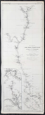
1861 Petermann Antique Map of 4th John McDouall Stuart Expedition in Australia
- Title : Karte von J. Mac Douall Stuarts Reise durch das innere von Australien, 6 Marz bis 25 August 1860...Gotha Justus Perthes 1861
- 21 1/2in x 8 1/4in (540mm x 210mm)
- Condition: (A+) Fine Condition
- Date : 1861
- Ref #: 82057
Description:
This long finely engraved original antique map of the expedition of John McDouall Stuart 4th expedition into the interior of Australia between March and August 1860 by Augustus Heinrich Petermann was engraved in 1861 - dated - and was published by Justus Perthes, Gotha Germany.
General Definitions:
Paper thickness and quality: - Heavy and stable
Paper color : - off white
Age of map color: - Original
Colors used: - Red
General color appearance: - Authentic
Paper size: - 21 1/2in x 8 1/4in (540mm x 210mm)
Plate size: - 21 1/2in x 8 1/4in (540mm x 210mm)
Margins: - Min 1/2in (12mm)
Imperfections:
Margins: - None
Plate area: - Folds as issued
Verso: - None
Background:
John McDouall Stuart (7 September 1815 – 5 June 1866), often referred to as simply McDouall Stuart, was a Scottish explorer and one of the most accomplished of all Australia\'s inland explorers.
Stuart led the first successful expedition to traverse the Australian mainland from south to north and return, through the centre of the continent. His experience and the care he showed for his team ensured he never lost a man, despite the harshness of the country he encountered.
The explorations of Stuart eventually resulted in the 1863 annexation of a huge area of country to the Government of South Australia. This area became known as the Northern Territory. In 1911 the Commonwealth of Australia assumed responsibility for that area. In 1871-72 the Australian Overland Telegraph Line was constructed along Stuart\'s route. The principal road from Port Augusta to Darwin was also established essentially on his route and is now known as the Stuart Highway in his honour.
On 2 March 1860 the three men left Chambers Creek, aiming to find the centre of Australia. As always, Stuart travelled light, taking only as much as could be carried on a few pack horses. The secret to successful exploration, in Stuart\'s view, was to travel fast and avoid the delays and complications that always attend a large supply train.
By the time they reached Neales River (near present-day Oodnadatta) unexpected rain had ruined most of their stores and they continued on half-rations – something that Head, who had started the trip as a big man and weighed twice as much as Stuart, found difficult to adjust to. Water became more and more difficult to find and scurvy began to set in. Stuarts right eye was failing. Nevertheless, they found a major watercourse in early April which Stuart named the Finke River, and followed it north-west over the South Australian border to the MacDonnell Ranges, which he named after Sir Richard Graves MacDonnell, Governor of South Australia, on 12 April 1860.
On 22 April 1860, according to Stuarts calculations, the party reached the centre of the continent. Stuart wrote:
.......There is a high mount about two miles to the NNE which I hoped would be in the centre but on it tomorrow I will raise a cone of stones and plant the Flag there and will name it Mount Sturt after my excellent and esteemed commander of the expedition in 1844 and 45, Captain Sturt, as a mark of gratitude for the great kindness I received from him during that journey.
In fact the mountain became known as Central Mount Stuart after Stuart himself, not his mentor Sturt, and geographers no longer regard it as the true centre of Australia. Nevertheless, it retains its symbolic value......
The explorers were unable to progress much further north. Lack of water forced them back again and again. Stuart\'s scurvy was growing worse, Head was now half his original weight, and only Kekwick remained capable of heavy work. Then, on 22 May, it rained. With water now available nearly every day, they made good mileage and by mid June were able to reach a riverbed which Stuart named Tennants Creek (now the site of the township Tennant Creek). The worst of the country was now behind them and they were only about 800 km from the coast.
From here, however, progress seemed impossible. A four-day excursion to the north-west found no water at all and they had to retreat. After giving the horses a week to recover, they tried heading due north. They found another creek (later named Attack Creek) but were blocked by heavy scrub. Unlike those further south, the Warramunga Aboriginal people were hostile. On 26 June they raided the explorers camp. One stole the shoeing rasp (which Stuart was able to recover); others threw boomerangs at the horses and set fire to the grass around the camp. Like Sturt (and unlike some of the other Australian explorers) Stuart generally got on well with the Aboriginal people he encountered but he was unable to negotiate with this group and considered it unsafe to continue. That night, with even the indefatigable Kekwick complaining of weakness, the explorers abandoned their attempt to reach the north coast and reluctantly turned south.
It was 2,400 kilometres to Adelaide, all three men had scurvy, supplies were very short, the horses were in poor condition, and the country was drying out. Nevertheless, the party pressed on at Stuarts customary rapid pace. They reached the safety of Chambers Creek in August. A few days earlier, on 20 August 1860, the larger Burke and Wills expedition had finally left Melbourne.
Stuart reached Adelaide in October 1860. Although he had narrowly failed to cross the continent, his achievement in determining the centre was immense, ranked with Spekes discovery of the source of the Nile. Stuart had solved that which he attempted with Capt. Sturt 15 years earlier – the riddle of the nature of the centre of the great Australian continent. He was awarded the Royal Geographical Societys Patron\'s Medal – becoming only the second person to receive both the Patron\'s Medal and a gold watch (the other was Dr Livingstone). Belatedly, even the South Australian government started to recognise Stuart\'s abilities, and was honoured with a public breakfast at White\'s Rooms
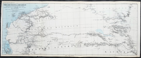
1876 Petermann Antique Map Expedition Ernest Giles Western & South Australia, 1875
- Title : Thomas Elders Expedition durch Inner-Australien vom Beltana im Osten bis Perth im Westen, Ausgefuhrt Durch E. Giles Mai - Nov 1875
- Size: 27in x 11in (285mm x 280mm)
- Condition: (A+) Fine Condition
- Date : 1876
- Ref #: 82054
Description:
This early folding original antique lithograph map of Western & South Australia - from Perth to Lake Torrens South Australia covering the 3rd & 4th expedition of the explorer Ernest Giles in 1875 by Augustus Heinrich Petermann was engraved in 1877 - dated - and was published by Justus Perthes, Gotha Germany.
General Definitions:
Paper thickness and quality: - Heavy and stable
Paper color : - off white
Age of map color: - Original
Colors used: - Blue, red, yellow
General color appearance: - Authentic
Paper size: - 27in x 11in (285mm x 280mm)
Plate size: - 27in x 11in (285mm x 280mm)
Margins: - Min 1/2in (12mm)
Imperfections:
Margins: - None
Plate area: - Folds as issued
Verso: - None
Background:
William Ernest Powell Giles 1835 – 1897 best known as Ernest Giles, was an Australian explorer who led five major expeditions in central Australia.
Giles did not attempt an organised expedition until 1872, when with two other men he left Chambers Pillar, South Australia (now in the Northern Territory), on 22 August and traversed much previously untrodden country to the north-west and west. Finding their way barred by Lake Amadeus and that their horses were getting very weak, a return was made to the Finke River and then to Charlotte Waters and Adelaide, where Giles arrived in January 1873. Giles looked upon his expedition as a failure, but he had done well considering the size and equipment of his party.
Giles friend Baron von Mueller raised a subscription so that a new expedition could be made. The services of William Tietkens as first assistant were obtained, and with two other men a start was made on 4 August 1873. The journey began considerably south from the previous expedition and from the Alberga River a generally western course was traversed. A month later in the Musgrave Ranges a fine running river was found and named the Ferdinand and by 3 October 1873 the party was approaching longitude 128 East. The country was extremely dry and though tested in various directions it was a constant struggle to get enough water to keep the horses going. Early in November, having passed longitude 126, a partial return was made and on 20 December 1873 the neighbourhood of Mount Scott was reached. A turn to the north and then west was made and the farthest westerly point was reached on 23 April 1874. Giles and one of the men, Alfred Gibson, had been scouting ahead when the latter\'s horse died. Giles gave him his own horse with instructions to follow their tracks back and obtain assistance. Giles made his way back to their depot on foot in eight days, almost completely exhausted, to find that Gibson had not reached the camp. A search was made for him for several days without success. The stores were almost finished, nothing further could be done, and on 21 May 1874 the return journey began. Giles named the desert Gibson Desert after his companion. On 24 June 1874 they were on a good track to the Finke River and on 13 July 1874 Charlotte Waters was reached. Giles had again failed to cross the continent, but in the circumstances all had been done that was possible.
Giles was the first European to see the rock formations of The Olgas, now known by their Aboriginal name of Kata Tjuta, and Lake Amadeus. He had wanted to name these Mt Mueller and Lake Ferdinand respectively, to honour his benefactor Baron Ferdinand von Mueller, however Mueller prevailed on him to instead honour the King Amadeus of Spain and Queen Olga of Württemberg. Giles supposedly discovered Uluru (formerly Ayers Rock), but was beaten to the claim by a competing explorer, William Gosse.
Early in 1875 Giles prepared his diaries for publication under the title Geographic Travels in Central Australia, and on 13 March 1875, with the generous help of Sir Thomas Elder, he began his third expedition. Proceeding considerably to the north from Fowler\'s Bay the country was found to be very dry. Retracing his steps Giles turned east, and eventually going round the north side of Lake Torrens reached Elder\'s station at Beltana. There the preparations for his fourth journey were made, and with Tietkens again his lieutenant, and with what Giles had always wanted, a caravan of camels, a start was made on 6 May. Port Augusta was reached on 23 May and, after taking a northerly course to clear the lakes, a generally westerly course was followed. Some water was carried, and the party was saved the continual excursions in search of water for horses that had caused so much difficulty during previous expeditions. Towards the end of September over 323 miles (520 km) had been covered in 17 days without finding water, when on 25 September the native Tommy found an abundant supply in a small hollow between sand dunes at Queen Victoria Spring, and the party was saved. After a rest of nine days the journey was resumed on 6 October the course being still west. Ten days later the expedition was attacked by a large body of aborigines and Giles was compelled to fire on them. On 4 November they met a white stockman at Tootra out-camp, east of Bindi Bindi. Their course was west to Walebing Station, then south-west and on 11 November they arrived at New Norcia where they were welcomed by Bishop Salvado. On 17 November 1875 the party arrived at Guildford and Perth the next day, where they received an enthusiastic reception.
Giles stayed for two months at Perth. Tietkens and Jess Young, another member of the expedition, went back to Adelaide by sea, and on 13 January 1876 Giles began the return journey taking a course generally about 400 miles north of the last journey. He arrived at Adelaide in September 1876 after a good journey during which the camels were found to be invaluable.
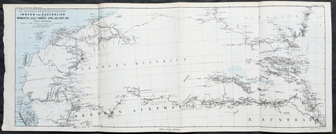
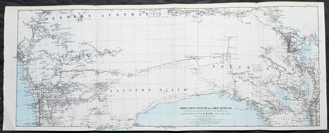
1876 Petermann Antique Map Western & South Australia - Warburton, Giles, Forrest
- Title : Die Neuesten Entdeckungsreisen im Inner-Australien von Warburton, Giles, Forrest, April 1873 - Sept 1874
- Size: 27in x 11in (285mm x 280mm)
- Condition: (A+) Fine Condition
- Date : 1876
- Ref #: 82055
Description:
This early folding original antique lithograph map of Western & South Australia and Alexandria land (Northern Territory) with the tracks of 3 explorers - in 1873 & 1874 - Peter Egerton-Warburton, Ernest Giles & Alexander Forrest by Augustus Heinrich Petermann was engraved in 1876 - dated - and was published by Justus Perthes, Gotha Germany.
General Definitions:
Paper thickness and quality: - Heavy and stable
Paper color : - off white
Age of map color: - Original
Colors used: - Blue, red, yellow
General color appearance: - Authentic
Paper size: - 27in x 11in (285mm x 280mm)
Plate size: - 27in x 11in (285mm x 280mm)
Margins: - Min 1/2in (12mm)
Imperfections:
Margins: - None
Plate area: - Folds as issued
Verso: - None
Background:
Colonel Peter Egerton-Warburton CMG (1813–1889), was a British military officer, Commissioner of Police for South Australia, and an Australian explorer. In 1872 he sealed his legacy through a particularly epic expedition from Adelaide crossing the arid centre of Australia to the coast of Western Australia via Alice Springs.
William Ernest Powell Giles (1835 – 1897) best known as Ernest Giles, was an Australian explorer who led five major expeditions in central Australia.
Alexander Forrest CMG (1849 – 1901) was an explorer and surveyor of Western Australia, and later also a member of parliament.
1877 Petermann Antique Map Expedition of Ernest Giles Western & South Australia in 1876
- Title : Thomas Elders Expedition durch Inner-Australien vom Murchison im Westen, bis zum Neales im Osten, Ausgefuhrt Durch E. Giles April-Aug 1876
- Size: 27in x 11in (285mm x 280mm)
- Condition: (A+) Fine Condition
- Date : 1877
- Ref #: 82056
Description:
This early folding original antique lithograph map of central Western & South Australia - from Sharks Bay to border of South Australia and Alexandra Land (Northern Territory) just south of Ayers Rock, covering the 5th and final expedition of the explorer Ernest Giles in 1876 by Augustus Heinrich Petermann was engraved in 1877 - dated - and was published by Justus Perthes, Gotha Germany.
General Definitions:
Paper thickness and quality: - Heavy and stable
Paper color : - off white
Age of map color: - Original
Colors used: - Blue, red, yellow
General color appearance: - Authentic
Paper size: - 27in x 11in (285mm x 280mm)
Plate size: - 27in x 11in (285mm x 280mm)
Margins: - Min 1/2in (12mm)
Imperfections:
Margins: - None
Plate area: - Folds as issued
Verso: - None
Background:
William Ernest Powell Giles 1835 – 1897 best known as Ernest Giles, was an Australian explorer who led five major expeditions in central Australia.
Giles did not attempt an organised expedition until 1872, when with two other men he left Chambers Pillar, South Australia (now in the Northern Territory), on 22 August and traversed much previously untrodden country to the north-west and west. Finding their way barred by Lake Amadeus and that their horses were getting very weak, a return was made to the Finke River and then to Charlotte Waters and Adelaide, where Giles arrived in January 1873. Giles looked upon his expedition as a failure, but he had done well considering the size and equipment of his party.
Giles friend Baron von Mueller raised a subscription so that a new expedition could be made. The services of William Tietkens as first assistant were obtained, and with two other men a start was made on 4 August 1873. The journey began considerably south from the previous expedition and from the Alberga River a generally western course was traversed. A month later in the Musgrave Ranges a fine running river was found and named the Ferdinand and by 3 October 1873 the party was approaching longitude 128 East. The country was extremely dry and though tested in various directions it was a constant struggle to get enough water to keep the horses going. Early in November, having passed longitude 126, a partial return was made and on 20 December 1873 the neighbourhood of Mount Scott was reached. A turn to the north and then west was made and the farthest westerly point was reached on 23 April 1874. Giles and one of the men, Alfred Gibson, had been scouting ahead when the latter\'s horse died. Giles gave him his own horse with instructions to follow their tracks back and obtain assistance. Giles made his way back to their depot on foot in eight days, almost completely exhausted, to find that Gibson had not reached the camp. A search was made for him for several days without success. The stores were almost finished, nothing further could be done, and on 21 May 1874 the return journey began. Giles named the desert Gibson Desert after his companion. On 24 June 1874 they were on a good track to the Finke River and on 13 July 1874 Charlotte Waters was reached. Giles had again failed to cross the continent, but in the circumstances all had been done that was possible.
Giles was the first European to see the rock formations of The Olgas, now known by their Aboriginal name of Kata Tjuta, and Lake Amadeus. He had wanted to name these Mt Mueller and Lake Ferdinand respectively, to honour his benefactor Baron Ferdinand von Mueller, however Mueller prevailed on him to instead honour the King Amadeus of Spain and Queen Olga of Württemberg. Giles supposedly discovered Uluru (formerly Ayers Rock), but was beaten to the claim by a competing explorer, William Gosse.
Early in 1875 Giles prepared his diaries for publication under the title Geographic Travels in Central Australia, and on 13 March 1875, with the generous help of Sir Thomas Elder, he began his third expedition. Proceeding considerably to the north from Fowler\'s Bay the country was found to be very dry. Retracing his steps Giles turned east, and eventually going round the north side of Lake Torrens reached Elder\'s station at Beltana. There the preparations for his fourth journey were made, and with Tietkens again his lieutenant, and with what Giles had always wanted, a caravan of camels, a start was made on 6 May. Port Augusta was reached on 23 May and, after taking a northerly course to clear the lakes, a generally westerly course was followed. Some water was carried, and the party was saved the continual excursions in search of water for horses that had caused so much difficulty during previous expeditions. Towards the end of September over 323 miles (520 km) had been covered in 17 days without finding water, when on 25 September the native Tommy found an abundant supply in a small hollow between sand dunes at Queen Victoria Spring, and the party was saved. After a rest of nine days the journey was resumed on 6 October the course being still west. Ten days later the expedition was attacked by a large body of aborigines and Giles was compelled to fire on them. On 4 November they met a white stockman at Tootra out-camp, east of Bindi Bindi. Their course was west to Walebing Station, then south-west and on 11 November they arrived at New Norcia where they were welcomed by Bishop Salvado. On 17 November 1875 the party arrived at Guildford and Perth the next day, where they received an enthusiastic reception.
Giles stayed for two months at Perth. Tietkens and Jess Young, another member of the expedition, went back to Adelaide by sea, and on 13 January 1876 Giles began the return journey taking a course generally about 400 miles north of the last journey. He arrived at Adelaide in September 1876 after a good journey during which the camels were found to be invaluable.
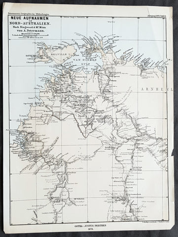
1878 Petermann Antique Map of Northern Territory Australia - William McMinn 1876
- Title : Neue Aufnahmen in Nord-Australien Nach. Ringwood & Mc Minn...Gotha: Justus Perthes 1878
- 10 1/2in x 8 1/2in (265mm x 215mm)
- Condition: (A+) Fine Condition
- Date : 1878
- Ref #: 82058
Description:
This scarce original antique lithograph map of north-west Northern Territory, Australia showing Palmerston at Port Darwin, place names and exploration routes, including that of William McMinn in 1876, by Augustus Heinrich Petermann was engraved in 1878 - dated - and was published by Justus Perthes, Gotha Germany.
General Definitions:
Paper thickness and quality: - Heavy and stable
Paper color : - off white
Age of map color: - Original
Colors used: - Yellow, blue
General color appearance: - Authentic
Paper size: - 10 1/2in x 8 1/2in (265mm x 215mm)
Plate size: - 10 1/2in x 8 1/2in (265mm x 215mm)
Margins: - Min 1/2in (12mm)
Imperfections:
Margins: - None
Plate area: - None
Verso: - None
Background:
William McMinn (1844 – 14 February 1884) was an Australian surveyor and architect, based in Adelaide.
He was born in Newry, County Down, Ireland, a son of Joseph McMinn and his wife Martha McMinn (née Hamill), who with their large family emigrated to Adelaide on the Albatross, arriving in September 1850.
After completing school, he was apprenticed to the architect James Macgeorge, but first practiced as a surveyor. He was involved in Boyle Travers Finniss\'s ill-fated 1865 expedition to Northern Australia surveying the area around the Adelaide River. Following the desertion of a majority of the party to Singapore, McMinn and 5 others purchased a 23-foot open boat which they named the Forlorn Hope and sailed it 2,000 miles (3,200 km) to Champion Bay, Geraldton, Western Australia. He was later involved in the 1872 surveying of the Overland Telegraph from Port Augusta to Darwin.
McMinn began practising as an architect in 1867, briefly in partnership with Daniel Garlick, and later with some others, but usually independently. He designed many grand private residences, but also designed or assisted in the design of many of Adelaide\'s grand public buildings. Whilst in partnership with Edward John Woods, he designed the original Venetian Gothic building of the University of Adelaide, considered his greatest work.
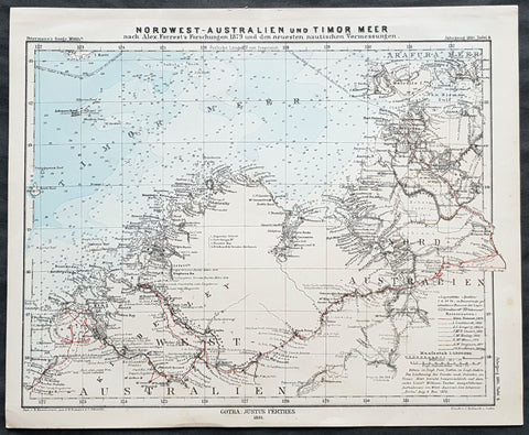
1881 Petermann Antique Map North Western Australia - Tracks of Alexander Forrest
- Title : Nordwest-Australien und Timor Meer nach Alex. Forrests Forschungen 1879 und den neuesten nautischen Vermessungen
- 10 1/2in x 8 1/2in (265mm x 215mm)
- Condition: (A+) Fine Condition
- Date : 1881
- Ref #: 82059
Description:
This early original antique lithograph map of Northwest Australia, from Roebuck Bay (pre-Broome) to Darwin, with the tracks of 8 explorers including Alexander Forrest - with 8 pages of text on Forests exploration - by Augustus Heinrich Petermann was engraved in 1881 - dated - and was published by Justus Perthes, Gotha Germany.
General Definitions:
Paper thickness and quality: - Heavy and stable
Paper color : - off white
Age of map color: - Original
Colors used: - Blue, red, yellow
General color appearance: - Authentic
Paper size: - 10 1/2in x 8 1/2in (265mm x 215mm)
Plate size: - 10 1/2in x 8 1/2in (265mm x 215mm)
Margins: - Min 1/2in (12mm)
Imperfections:
Margins: - None
Plate area: - None
Verso: - None
Background:
Alexander Forrest CMG 1849 – 1901 was an explorer and surveyor of Western Australia, and later also a member of parliament.
As a government surveyor, Forrest explored many areas of remote Western Australia, particularly the Kimberley region. Several of his expeditions were conducted alongside his brother, Sir John Forrest, who became the first Premier of Western Australia. In later life, Forrest served in the unicameral Legislative Council from 1887 to 1890, representing the seat of Kimberley. Following the advent of responsible government, he was elected to the Legislative Assembly, representing the seat of West Kimberley from 1890 until his death. He was also mayor of Perth on two occasions, from 1892 to 1895 and from 1897 to 1900.
Forrest explored areas of Western Australia under contract to the Survey Department, particularly the Kimberley region, during the 1870s and 1880s. Much of his exploration was done with his brother John Forrest who became the first Premier of Western Australia.
In 1870, a party of six men including Alexander and his brother John left Perth. Five months later they reached Adelaide. In 1874, Alexander was part of another party again including brother John which took a more northerly route from Geraldton to the east to the Murchison River.
In 1879, Alexander led his own expedition of eight men from De Grey River to the telegraph line into the area now known as the Kimberley. The expedition left on 25 February 1879 and reached Beagle Bay on 10 April 1879. The coast was then skirted to the Fitzroy River which was followed for 240 miles (390 km); but Forrest\'s progress was then stopped by mountains which appeared to be impassable. He eventually worked round the southern end of the range and discovered some valuable country. Good water was found until the Victoria River was reached on 18 August 1879, but great difficulties were met with before reaching the telegraph line 13 days later. From there they made their way to Palmerston, then the capital of the Northern Territory, and they arrived on 7 October 1879. The party was often in danger of starvation, on more than one occasion a packhorse had to be killed for food, and in the last dash for the telegraph line, Forrest and one companion who had gone on ahead almost perished from thirst. The two aboriginal assistants were quite helpless for the last 300 miles (480 km) of the journey, and one of them never recovered from its effects, dying a few months later. The expedition ranks among the most valuable pieces of Australian exploration as large tracts of good pasturage were discovered. Forrest published his Journal of Expedition from De Grey to Port Darwin in Perth in 1880.
In 1891, through a syndicate comprising Charles Crossland and George Leake, Alexander Forrest commenced the subdivision of what would later become the affluent Perth suburb of Peppermint Grove. He was also associated with the first of three quarries that exist on the edge of Greenmount Hill. In 1893, he negotiated the contract with the Adelaide Steamship Company for serving West Australian ports.
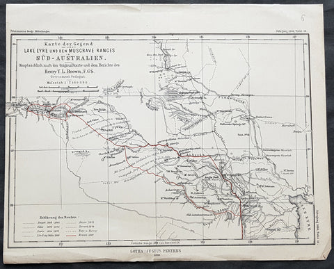
1890 Petermann Antique Map Lake Eyre to The Musgrave Ranges South Australia
- Title : Karte der Gegend zwischen Lake Eyre den Musgrave Ranges in Sud-Australien...Gotha: Justus Perthes 1890
- 10 1/2in x 8 1/2in (265mm x 215mm)
- Condition: (A+) Fine Condition
- Date : 1890
- Ref #: 82060
Description:
This original antique lithograph map of the area between Lake Eyre the Musgrave ranges in South Australia - with the tracks of 8 explorers of the region - by Augustus Heinrich Petermann was engraved in 1890 - dated - and was published by Justus Perthes, Gotha Germany.
General Definitions:
Paper thickness and quality: - Heavy and stable
Paper color : - off white
Age of map color: - Original
Colors used: - Red
General color appearance: - Authentic
Paper size: - 10 1/2in x 8 1/2in (265mm x 215mm)
Plate size: - 10 1/2in x 8 1/2in (265mm x 215mm)
Margins: - Min 1/2in (12mm)
Imperfections:
Margins: - None
Plate area: - Folds as issued
Verso: - None
Background:
The tracks of 8 different explorers are covered in this map. They are:
1. Sturat 1858-62
2. Giles 1873 - 1876
3. Lewis 1874 - 1875
4. Lindsay 1885 & 86
5. Gosse 1872
6. Forrest 1874
7. Ross & Harvey
8. Brown 1889