Adolphe Hippolyte Dufour
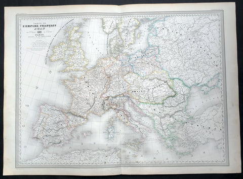
1856 A H Dufour Very Large Antique Map of The Different Empires of Europe
- Title : Carte De L Empire Francais par A H Dufour Gravee CH Dyonnet..1856
- Ref #: 61027
- Size: 33in x 24in (840mm x 610mm)
- Date : 1856
- Condition: (A+) Fine Condition
Description:
This very large, magnificent hand coloured original copper plate antique map of the political borders of Europe and the various Empires that ruled the continent at the time French, Austrian, Rhine Conference, Italian States, Russian, Ottoman etc by Adolphe Hippolyte Dufour was engraved by Charles Dyonnet in 1856 - dated in the title - for Dufours 1860 edition of his monumental elephant folio Atlas Physique, Historique et Politique Geographie Moderne published by Pauline Et La Chevalier, Paris.
The 19th century French cartographer Auguste-Henri Dufour began publishing the dramatic elephant folio Atlas Universel, also occasionally titled Grand Atlas Universal, around 1855. Several editions appeared between its initial publication in the 1850s and a final run c. 1870. The 1863 and 1864 editions in particular are highly desirable among collectors because the United States and North America maps illustrate the proposed, but unrealized, state of Corona (roughly modern day Utah). The atlas contained roughly 40 maps, most of which were engraved by Louis Antoine (the maps) and Deletre (typography) under the supervision of Charles Dyonnet, official engraver of the Depot de la Marine. The Atlas Universal was published in Paris and edited by the firm of Paulin et le Chevalier, 60 Rue Richelieu.
General Definitions:
Paper thickness and quality: - Heavy and stable
Paper color : - off white
Age of map color: - Original
Colors used: - Yellow, green, blue, pink
General color appearance: - Authentic
Paper size: - 33in x 24in (840mm x 610mm)
Plate size: - 33in x 24in (840mm x 610mm)
Margins: - Min 1in (25mm)
Imperfections:
Margins: - Light age toning in margins
Plate area: - None
Verso: - None
Background:
Charles Dyonnet 1822 - 1880 was an extremely active Paris based engraver working in the mid to late 19th century. From his offices at 220 Rue St. Jacques, Paris, Dyonnet engraved numerous maps for many of the most prominent 19th French cartographic publishers including Vuillemin, Dufour, Fremin and Duvotenay. From 1850-1861, he held the coveted position of Graveur du Dépot de la Marine, and in this position engraved numerous French naval and military maps. Dyonnet had a detail oriented and aesthetically minded hand and is responsible from some of the most beautiful French maps to emerge during the 19th century. (Ref: M&B; Tooley)

1856 A H Dufour Very Large Antique Political map of Europe - Mountains
- Title : Carte Generale L Europe Actuelle Dressee A H Dufour Gravee CH Dyonnet..1856
- Ref #: 61020
- Size: 33in x 24in (840mm x 610mm)
- Date : 1856
- Condition: (A+) Fine Condition
Description:
This very large, magnificent hand coloured original copper plate antique map of the political borders of Europe in the mid 19th century - with a list of European mountains at the bottom of the map - by Adolphe Hippolyte Dufour was engraved by Charles Dyonnet in 1856 - dated in the title - for Dufours 1860 edition of his monumental elephant folio Atlas Physique, Historique et Politique Geographie Moderne published by Pauline Et La Chevalier, Paris.
The 19th century French cartographer Auguste-Henri Dufour began publishing the dramatic elephant folio Atlas Universel, also occasionally titled Grand Atlas Universal, around 1855. Several editions appeared between its initial publication in the 1850s and a final run c. 1870. The 1863 and 1864 editions in particular are highly desirable among collectors because the United States and North America maps illustrate the proposed, but unrealized, state of Corona (roughly modern day Utah). The atlas contained roughly 40 maps, most of which were engraved by Louis Antoine (the maps) and Deletre (typography) under the supervision of Charles Dyonnet, official engraver of the Depot de la Marine. The Atlas Universal was published in Paris and edited by the firm of Paulin et le Chevalier, 60 Rue Richelieu.
General Definitions:
Paper thickness and quality: - Heavy and stable
Paper color : - off white
Age of map color: - Original
Colors used: - Yellow, green, blue, pink
General color appearance: - Authentic
Paper size: - 33in x 24in (840mm x 610mm)
Plate size: - 33in x 24in (840mm x 610mm)
Margins: - Min 1in (25mm)
Imperfections:
Margins: - Light age toning in margins
Plate area: - None
Verso: - None
Background:
Charles Dyonnet 1822 - 1880 was an extremely active Paris based engraver working in the mid to late 19th century. From his offices at 220 Rue St. Jacques, Paris, Dyonnet engraved numerous maps for many of the most prominent 19th French cartographic publishers including Vuillemin, Dufour, Fremin and Duvotenay. From 1850-1861, he held the coveted position of Graveur du Dépot de la Marine, and in this position engraved numerous French naval and military maps. Dyonnet had a detail oriented and aesthetically minded hand and is responsible from some of the most beautiful French maps to emerge during the 19th century. (Ref: M&B; Tooley)
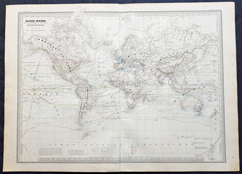
1856 A H Dufour Very Large Antique World Map on Mercators Projection - Scarce
- Title : Mappe-Monde Planispherique Physique et Hydrographique. CH Dyonnet..1856
- Ref #: 61019
- Size: 33in x 24in (840mm x 610mm)
- Date : 1856
- Condition: (A+) Fine Condition
Description:
This very large, magnificent hand coloured original copper plate antique World Map on Mercators Projection -adorned with scientific data - by Adolphe Hippolyte Dufour was engraved by Charles Dyonnet in 1857 - dated in the title - for Dufours 1860 edition of his monumental elephant folio Atlas Physique, Historique et Politique Geographie Modernepublished by Pauline Et La Chevalier, Paris.
The 19th century French cartographer Auguste-Henri Dufour began publishing the dramatic elephant folio Atlas Universel, also occasionally titled Grand Atlas Universal, around 1855. Several editions appeared between its initial publication in the 1850s and a final run c. 1870. The 1863 and 1864 editions in particular are highly desirable among collectors because the United States and North America maps illustrate the proposed, but unrealized, state of Corona (roughly modern day Utah). The atlas contained roughly 40 maps, most of which were engraved by Louis Antoine (the maps) and Deletre (typography) under the supervision of Charles Dyonnet, official engraver of the Depot de la Marine. The Atlas Universal was published in Paris and edited by the firm of Paulin et le Chevalier, 60 Rue Richelieu.
General Definitions:
Paper thickness and quality: - Heavy and stable
Paper color : - off white
Age of map color: - Original
Colors used: - Yellow, green, blue, pink
General color appearance: - Authentic
Paper size: - 33in x 24in (840mm x 610mm)
Plate size: - 33in x 24in (840mm x 610mm)
Margins: - Min 1in (25mm)
Imperfections:
Margins: - Light age toning in margins
Plate area: - None
Verso: - None
Background:
Charles Dyonnet 1822 - 1880 was an extremely active Paris based engraver working in the mid to late 19th century. From his offices at 220 Rue St. Jacques, Paris, Dyonnet engraved numerous maps for many of the most prominent 19th French cartographic publishers including Vuillemin, Dufour, Fremin and Duvotenay. From 1850-1861, he held the coveted position of Graveur du Dépot de la Marine, and in this position engraved numerous French naval and military maps. Dyonnet had a detail oriented and aesthetically minded hand and is responsible from some of the most beautiful French maps to emerge during the 19th century. (Ref: M&B; Tooley)
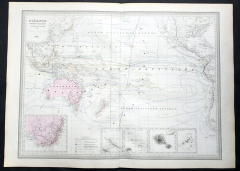
1857 A H Dufour Very Large Antique Map of Australia, New Zealand & South Pacific
- Title : Oceanie Dressee par A H Dufour Gravee CH Dyonnet..1857
- Ref #: 61026
- Size: 33in x 24in (840mm x 610mm)
- Date : 1857
- Condition: (A+) Fine Condition
Description:
This very large, magnificent hand coloured original copper plate antique map of Australia, New Zealand, Oceania & The Pacific, showing the Ocean Currents and 5 inset maps (NSW & Victoria Australia, Gambier Islands, Tahiti, Marquesas Isles & New Caledonia) by Adolphe Hippolyte Dufour was engraved by Charles Dyonnet in 1856 - dated in the title - for Dufours 1860 edition of his monumental elephant folio Atlas Physique, Historique et Politique Geographie Moderne published by Pauline Et La Chevalier, Paris.
The 19th century French cartographer Auguste-Henri Dufour began publishing the dramatic elephant folio Atlas Universel, also occasionally titled Grand Atlas Universal, around 1855. Several editions appeared between its initial publication in the 1850s and a final run c. 1870. The 1863 and 1864 editions in particular are highly desirable among collectors because the United States and North America maps illustrate the proposed, but unrealized, state of Corona (roughly modern day Utah). The atlas contained roughly 40 maps, most of which were engraved by Louis Antoine (the maps) and Deletre (typography) under the supervision of Charles Dyonnet, official engraver of the Depot de la Marine. The Atlas Universal was published in Paris and edited by the firm of Paulin et le Chevalier, 60 Rue Richelieu.
General Definitions:
Paper thickness and quality: - Heavy and stable
Paper color : - off white
Age of map color: - Original
Colors used: - Yellow, green, blue, pink
General color appearance: - Authentic
Paper size: - 33in x 24in (840mm x 610mm)
Plate size: - 33in x 24in (840mm x 610mm)
Margins: - Min 1in (25mm)
Imperfections:
Margins: - Light age toning in margins
Plate area: - None
Verso: - None
Background:
Charles Dyonnet 1822 - 1880 was an extremely active Paris based engraver working in the mid to late 19th century. From his offices at 220 Rue St. Jacques, Paris, Dyonnet engraved numerous maps for many of the most prominent 19th French cartographic publishers including Vuillemin, Dufour, Fremin and Duvotenay. From 1850-1861, he held the coveted position of Graveur du Dépot de la Marine, and in this position engraved numerous French naval and military maps. Dyonnet had a detail oriented and aesthetically minded hand and is responsible from some of the most beautiful French maps to emerge during the 19th century. (Ref: M&B; Tooley)

1857 A H Dufour Very Large Antique Map of South America - Beautiful
- Title : Amerique Du Sud dresee par A H Dufour...1857
- Ref #: 61024
- Size: 33in x 24in (840mm x 610mm)
- Date : 1857
- Condition: (A+) Fine Condition
Description:
This very large, magnificent hand coloured original copper plate antique map of South America by Adolphe Hippolyte Dufour was engraved by Charles Dyonnet in 1857 - dated in the title - for Dufours 1860 edition of his monumental elephant folio Atlas Physique, Historique et Politique Geographie Moderne published by Pauline Et La Chevalier, Paris.
The 19th century French cartographer Auguste-Henri Dufour began publishing the dramatic elephant folio Atlas Universel, also occasionally titled Grand Atlas Universal, around 1855. Several editions appeared between its initial publication in the 1850s and a final run c. 1870. The 1863 and 1864 editions in particular are highly desirable among collectors because the United States and North America maps illustrate the proposed, but unrealized, state of Corona (roughly modern day Utah). The atlas contained roughly 40 maps, most of which were engraved by Louis Antoine (the maps) and Deletre (typography) under the supervision of Charles Dyonnet, official engraver of the Depot de la Marine. The Atlas Universal was published in Paris and edited by the firm of Paulin et le Chevalier, 60 Rue Richelieu.
General Definitions:
Paper thickness and quality: - Heavy and stable
Paper color : - off white
Age of map color: - Original
Colors used: - Yellow, green, blue, pink
General color appearance: - Authentic
Paper size: - 33in x 24in (840mm x 610mm)
Plate size: - 33in x 24in (840mm x 610mm)
Margins: - Min 1in (25mm)
Imperfections:
Margins: - Light age toning in margins
Plate area: - None
Verso: - None
Background:
Charles Dyonnet 1822 - 1880 was an extremely active Paris based engraver working in the mid to late 19th century. From his offices at 220 Rue St. Jacques, Paris, Dyonnet engraved numerous maps for many of the most prominent 19th French cartographic publishers including Vuillemin, Dufour, Fremin and Duvotenay. From 1850-1861, he held the coveted position of Graveur du Dépot de la Marine, and in this position engraved numerous French naval and military maps. Dyonnet had a detail oriented and aesthetically minded hand and is responsible from some of the most beautiful French maps to emerge during the 19th century. (Ref: M&B; Tooley)
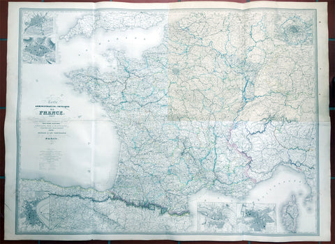
1857 Dufour Very Large Scarce Old, Antique Map of France - 4ft x 6ft
- Title : Carte Administrative et Physique de la France indiquant Les Canaan Les Riviers Navigable les routes, le Chemis de fer avec leurs stations Dresee par A.H. Dufour Gravee Par CH Dyonnet 1857
- Ref #: 61029
- Size: 62in x 46in (1.5m x 1.15m)
- Date : 1857
- Condition: (A) Very Good Condition
Description:
This scarce very large elephant folio 4 sheet - joined - hand coloured original map of France was engraved by Charles Dyonnet in 1857 - dated in the title - for Adolphe Hippolyte Dufour's monumental elephant folio Atlas Physique, Historique et Politique Geographie Moderne published by Pauline Et La Chevalier, Paris.
This uncommon elephant folio map is huge measuring overall 62in x 46in (1.5m x 1.15m) and is incredibly detailed. The map covers the whole of France including Corsica and parts of Spain, Germany and Switzerland.
The first sheet (top left in image) represents north-western France and includes two insets of Nantes and Rouen. The second sheet (top right) represents north-eastern France with an inset of Paris and its environs. The bottom right sheet depicts the south-eastern portions of France and includes two insets, one featuring Marseille and the other featuring Lyon. The last sheet on the bottom left is of southwest France.
An inset on Bordeaux is included and throughout illustrates roads, canals, railways, rivers, cities and other topographical features are noted.
Adolphe Hippolyte Dufour (1795 - 1865), also known as Auguste-Henri Dufour, was a Paris based map and atlas publisher active in the middle to late 19th century. Dufour claimed to be a student of another French cartographer, Emile Lapie. He is known to have worked with numerous other cartographers, publishers and engravers of the period including Charles Dyonnet and Duvotenay. His corpus includes numerous maps and atlases, the most striking of which is probably his monumental elephant folio Atlas Universel physique, historique et politique geographie ancienne et moderne. Dufour's student and successor was Alexandre Vuillemin.
Charles Dyonnet (fl. c. 1822 - c. 1880) was an extremely active Paris based engraver working in the mid to late 19th century. From his offices at 220 Rue St. Jacques, Paris, Dyonnet engraved numerous maps for many of the most prominent 19th French cartographic publishers including Vuillemin, Dufour, Fremin and Duvotenay. From 1850-1861, he held the coveted position of "Graveur du Dépot de la Marine," and in this position engraved numerous French naval and military maps. Dyonnet had a detail oriented and aesthetically minded hand and is responsible from some of the most beautiful French maps to emerge during the 19th century. (Ref: M&B; Tooley)
General Description:
Paper thickness and quality: - Heavy & stable
Paper color: - White
Age of map color: - Original
Colors used: - Yellow, red, green, blue
General color appearance: - Authentic
Paper size: - 62in x 46in (1.5m x 1.15m)
Paper size: - 62in x 46in (1.5m x 1.15m)
Margins: - Min 1in (24mm)
Imperfections:
Margins: - None
Plate area: - Top NE sheet age toning
Verso: - Soiling