
Tobias Conrad Lotter (1717 - 1777)
Profile :
Tobias Lotter was a German publisher and engraver who married the daughter of the elder Matthaus Seutter. He engraved many of Seutters maps and eventually succeeded to the business in 1756, becoming one of the better-known cartographers in the eighteenth-century German School. After his death the business was carried on by his son, M.A. Lotter
Tobias Conrad Lotter (12)
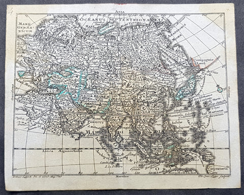
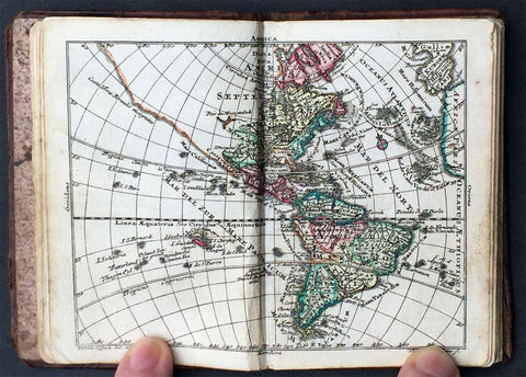
1747 Tobias Lotter Antique Miniature Map of Asia, Gulf of Carpentaria, Australia
- Title : Asia
- Size: 5 1/2in x 4 1/2in (140mm x 115mm)
- Condition: (A) Very Good Condition
- Date : 1747
- Ref #: 93110
Description:
This original copper plate engraved antique miniature map of Asia by Tobias Lotter was published in the 1747 edition of Atlas Geographicus Portatilis XXIX mappis orbis habitabilis regna exhibens.
General Definitions:
Paper thickness and quality: - Heavy and stable
Paper color : - off white
Age of map color: - Original
Colors used: - Green
General color appearance: - Authentic
Paper size: - 5 1/2in x 4 1/2in (140mm x 115mm)
Plate size: - 5 1/2in x 4 1/2in (140mm x 115mm)
Margins: - Min 1/4in (5mm)
Imperfections:
Margins: - Light age toning
Plate area: - Light age toning
Verso: - Light age toning
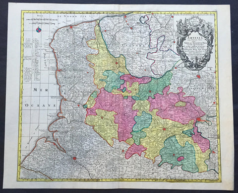
1756 Lotter Large Antique Map Artois & Pas-De-Calais & Flanders region of France
- Title : Artesia...Tob. Conradi Lotter
- Ref #: 50168
- Size: 25in x 20in (635mm x 510mm)
- Date : 1756
- Condition: (A+) Fine Condition
Description:
This large beautifully hand coloured original antique map of the Artois & Pas-De-Calais and Flanders region of France & Belgium was engraved by Tobias Conrad Lotter in 1756.
The map centres on the city of Arras north to Dunkirk, south to Abbeville and east to Douai (Ref: Tooley, M&B)
General Description:
Paper thickness and quality: - Heavy and stable
Paper color: - off white
Age of map color: - Original
Colors used: - Pink, green, yellow, blue
General color appearance: - Authentic
Paper size: - 25in x 21in (635mm x 535mm)
Plate size: - 22 ½in x 19 ½in (570mm x 495mm)
Margins: - Min 1/2in (12mm)
Imperfections:
Margins: - None
Plate area: - None
Verso: - None
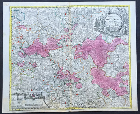
1756 Lotter Large Antique Map of Rhine Koblenz, Germany
- Title : Archiepiscopatus et Electoratus Moguntinus...
- Ref #: 50169
- Size: 25in x 20in (635mm x 510mm)
- Date : 1756
- Condition: (A+) Fine Condition
Description:
This large beautiful hand coloured original antique map of the Rhine River region of central western Germany was engraved by Tobias Conrad Lotter in 1756.
The map centres on the city of Frankfurt stretches along the Rhine River from Koblenz in the North to Speir in the South. Wertheim in the east to Kern in the west (Ref: Tooley, M&B)
General Description:
Paper thickness and quality: - Heavy and stable
Paper color: - off white
Age of map color: - Original
Colors used: - Pink, green, yellow, blue
General color appearance: - Authentic
Paper size: - 25in x 20in (635mm x 510mm)
Plate size: - 22 ½in x 19 ½in (570mm x 495mm)
Margins: - Min 1/2in (12mm)
Imperfections:
Margins: - None
Plate area: - None
Verso: - None
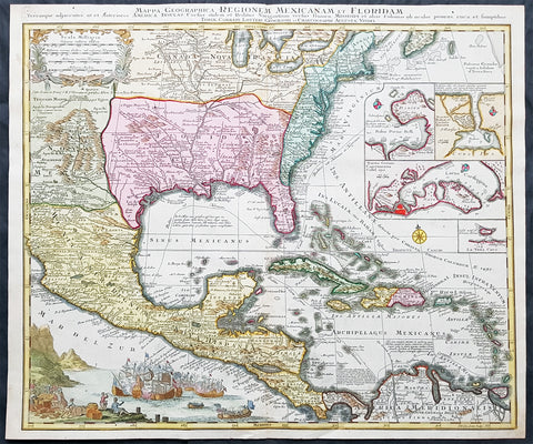
1758 Tobias Lotter Large Antique Map of North America, French Indian War
- Title : Mappa Geographica Regionem Mexicanam et Floridam. Terrasque adjacentes ut et Anteriors Americae Insulas Cursus itidem et Reditus Navigantium versus flumen Missisipi et alais Colonias ob oculos ponens eura et sumptibus Tobiae Conradi Lotteri, Geograph et Chalcograph Augustae Vindel...Tob. Con. Lotter Sculps
- Date : 1758
- Condition: (A+) Fine Condition
- Ref: 16495
- Size: 24in x 20 1/2in (610mm x 520mm)
Description:
One of the best and most beautifully executed, iconic 18th century antique maps of colonial North America. Engraved after the 1703 map of North America by Guillaume Delisle, it was re-issued by a number of iconic 18th century cartographers. This beautifully hand coloured original antique map is one of the best, both engraved and published by Tobias Conrad Lotter in 1758. It was published during the French-Indian or Seven Year War, the first real Global conflict.
The large sea battle to the bottom left is used to illustrate the ongoing conflict, and the changing ownership of North America is illustrated in the specific demarcation of the British, French and Spanish regions. To the right of the map are four inset plans of Spanish possessions in Panama, Havana, Cartagena and Vera Cruz.
This map is in exceptional condition, with beautiful original ahnd colour, a heavy engraving (denoting an early pressing) on clean heavy sturdy crisp paper with original margins, a superb map.
General Definitions:
Paper thickness and quality: - Heavy, stable & crisp
Paper color : - off white
Age of map color: - Original & early
Colors used: - Blue, pink, red, green, yellow
General color appearance: - Authentic
Paper size: - 24in x 20 1/2in (610mm x 520mm)
Plate size: - 22 1/2in x 19 ½in (570mm x 495mm)
Margins: - Min 1/2in (15mm)
Imperfections:
Margins: - None
Plate area: - None
Verso: - None
Background: The French and Indian War (1754–63) pitted the colonies of British America against those of New France, each side supported by military units from the parent country and by American Indian allies. At the start of the war, the French colonies had a population of roughly 60,000 settlers, compared with 2 million in the British colonies.
The British colonists were supported at various times by the Iroquois, Catawba, and Cherokee, and the French colonists were supported by Wabanaki Confederacy members Abenaki and Mi'kmaq, and Algonquin, Lenape, Ojibwa, Ottawa, Shawnee, and Wyandot. Fighting took place primarily along the frontiers between New France and the British colonies, from Virginia in the south to Newfoundland in the north. It began with a dispute over control of the confluence of the Allegheny River and Monongahela River called the Forks of the Ohio, and the site of the French Fort Duquesne in Pittsburgh, Pennsylvania. The dispute erupted into violence in the Battle of Jumonville Glen in May 1754, during which Virginia militiamen under the command of 22 year-old George Washington ambushed a French patrol.
In 1755, six colonial governors in North America met with General Edward Braddock, the newly arrived British Army commander, and planned a four-way attack on the French. None succeeded, and the main effort by Braddock proved a disaster; he lost the Battle of the Monongahela on July 9, 1755 and died a few days later. British operations failed in the frontier areas of the Province of Pennsylvania and the Province of New York during 1755–57 due to a combination of poor management, internal divisions, effective Canadian scouts, French regular forces, and Indian warrior allies. In 1755, the British captured Fort Beauséjour on the border separating Nova Scotia from Acadia, and they ordered the expulsion of the Acadians (1755–64) soon afterwards. Orders for the deportation were given by William Shirley, Commander-in-Chief, North America, without direction from Great Britain. The Acadians were expelled, both those captured in arms and those who had sworn the loyalty oath to His Britannic Majesty. Indians likewise were driven off the land to make way for settlers from New England.
The British colonial government fell in the region of Nova Scotia after several disastrous campaigns in 1757, including a failed expedition against Louisbourg and the Siege of Fort William Henry; this last was followed by Indians torturing and massacring their British victims. William Pitt came to power and significantly increased British military resources in the colonies at a time when France was unwilling to risk large convoys to aid the limited forces that they had in New France, preferring to concentrate their forces against Prussia and its allies who were now engaged in the Seven Years' War in Europe. Between 1758 and 1760, the British military launched a campaign to capture the Colony of Canada (part of New France). They succeeded in capturing territory in surrounding colonies and ultimately the city of Quebec (1759). The British later lost the Battle of Sainte-Foy west of Quebec (1760), but the French ceded Canada in accordance with the Treaty of Paris (1763).
France ceded its territory east of the Mississippi to Great Britain. It ceded French Louisiana west of the Mississippi River (including New Orleans) to its ally Spain in compensation for Spain's loss to Britain of Spanish Florida. (Spain had ceded Florida to Britain in exchange for the return of Havana, Cuba.) Frances colonial presence north of the Caribbean was reduced to the islands of Saint Pierre and Miquelon, confirming Great Britains position as the dominant colonial power in America.
1760 Tobias Lotter Antique Atlas with 33 Maps - World, Continents & Provincial Maps
- Title : Atlas Geographicus Portatilis XXIX mappis orbis habitabilis regna exhibens.
- Ref #: 61014
- Size: 32mo (tricesimo-secondo)
- Date : 1760
- Condition: (A) Very Good Condition
Description:
This beautiful original antique pocket atlas with 33 beautifully hand coloured copper-plate engraved antique maps with original Baroque engraved calf boards was published by Tobias Conrad Lotter and Tobias Lobeck, Augsberg in 1760.
General Description:
Paper thickness and quality: - Light and stable
Paper color: - Off white
Age of map color: - Original color:
Colors used: - Green, yellow, pink, orange.
General color appearance: - Authentic & beautiful
Atlas size: - 32mo (tricesimo-secondo)
Maps sizes: - 5 1/2in x 4 1/4in (140mm x 110mm)
Margins: - Min 1/4in (5mm)
Imperfections:
Margins: - Light soiling in margins
Plate area: - None
Verso: - None
Background:
Beautiful original travel atlas with 33 original hand coloured maps with full original color. Opens with an allegorical frontispiece, followed by a title page in an architectural cartouche, both drawn by Gottfried Eichler, junior.
The maps include the celestial and terrestrial hemispheres, the continents, and detailed maps of western and eastern Europe. Most maps are embellished with a fine title cartouche. Contemporary full embossed calf covers, extremities a little scuffed, corners worn back board slightly bent. Please see images for the map index page for reference.
The atlas was first published by Tobias Lotter, the son-in-law of Mattheus Seutter and Tobias Lobeck in 1747 with an accompanying almanac. This attractive and detailed little atlas was re-issued for many years, with the maps reprinted and with new maps added, but the title-page continued to report 29 maps. This edition has 33 maps with the extra maps including Saxonia Inferiors, Thuringia Pars, Westphalia Pars and Niederlande Spanisiche. (Ref: Tooley; M&B)
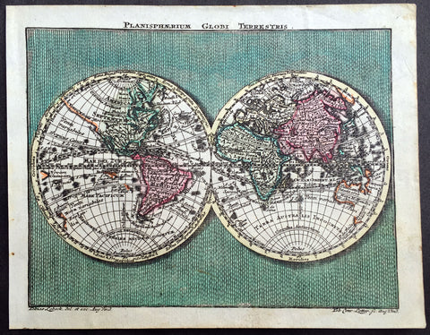
1762 Lotter Twin Hemisphere Antique World Map
- Title : Planisphaerium Globi Terestris
- Ref #: 70092
- Size: 5 1/2in x 4 1/2in (140mm x 115mm)
- Date : 1762
- Condition: (A+) Fine Condition
Description:
This beautifully hand coloured original antique Twin Hemisphere World Map by Tobias Conrad Lotter was engraved by Tobias Lobeck and published in the 1762 edition of Atlas Geographicus Portatilis, Augsburg.
The 18th century saw a cartographical revival in Germany and the increased output included some miniature atlases. This atlas is one such example with each map although small engraved with accurate and varied detail. (Ref: Tooley, M&B)
General Description:
Paper thickness and quality: - Heavy and stable
Paper color: - off white
Age of map color: - Original
Colors used: - Pink, green, yellow
General color appearance: - Authentic
Paper size: - 5 1/2in x 4 1/2in (140mm x 115mm)
Plate size: - 5 1/2in x 4 1/2in (140mm x 115mm)
Margins: - Min 1/4in (5mm)
Imperfections:
Margins: - None
Plate area: - None
Verso: - None
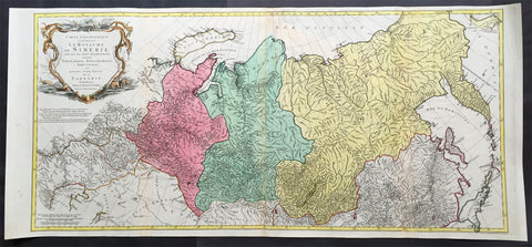
1770 Tobias Lotter Very Large Antique Map of Russia & Siberia
- Title : Carte géographique contenant le royaume de Sibérie
- Ref #: 61039
- Size: 44in x 20 1/2in (1.15m x 520mm)
- Date : 1770
- Condition: (A) Very Good Condition
Description:
This scarce, very large beautifully hand coloured original antique map of Russia and Siberia with parts of China was published by Tobias Conrad Lotter in 1770.
Background: Rare, highly detailed map of Russia & Siberia that is subdivided into provinces, namely Tobolsk, Jenissejesk, Irkutsk, and outer parts of the Tartary. In upper right corner inset-map of the Chukchi (Chukotsk) Peninsula. On the left side sheet is a large title cartouche set in a steppe landscape with reindeer sledge, whale and polar bears. Scale ca. 1 : 13,000,000 and engraved by Matthäus Albrecht Lotter for Tobias Conrad Lotter.
In about 1770 a map of Russia & Siberia by Ivan Fomic Truscot (1721-1786, comp. BMC XXII, 353) was published, that comprised the West Siberian states Tobolsk and Yeniseiesk only, but may have been quite available to Lotter, just as also the German edition of the third Russian general map by Truscot and Jacob F. Schmidt of 1776 was published by Lotter in 1784.
The comparison of the Asian north-eastern coast from Japan up to Cape Szalaginskoi (Cape Shelagskiy) together with the offshore islands there results in an astonishing similarity with representation and designation on Rigobert Bonne’s maps of Russia and the Chinese Tartary published by Lattré in Paris in 1771. Especially striking the form of Sakhalin that hitherto – but also still on the Truscot map of 1776 – appears far more stocky, here though shows a slimmer shape considerably closer to reality. Cape Patience known at least since the 1743 Utrecht edition of the map of Russia by Johann Matthias Haas (Augsburg 1684 – Wittenberg/Augsburg 1742) – Kaert van Het geheele Russische Keizerryk – already published by Homann Heirs in Nuremberg in 1730 + 39 here supposedly for the first time shown in unity with Sakhalin and, as the long-stretched southern half beginning west of the cape already recognizable there is missing here, together forming its southern tip.
Of great similarity, too, the still completely bulky representation of Jeso (= Hokkaido), filling up large parts of the Sea of Japan as known sufficiently from numerous, though by far not all maps of the 18th century. The Kurile Islands adjacent in northeastern direction – with rich detail designation, but without the denomination as chain of islands appearing at least in the 1784 edition of Truscot’s general map – with the obscure islands Terre des Etat (Iturup) and Terre de la Compagnie. Both, as also the often furthermore adjacent da Gama Land, had been supposedly finally left by Truscot to the memory of the great time of sometimes only vague discoveries.
Interestingly both islands are designated with hints to Russian maps in question marks. This probably to be seen as a sign for an independent work of Lotter who obviously drew his knowledge from different sources and not just copied a map he had got into his hands for a German edition. Further clue to the dating is, too, the taking over of the Chukchi (Chukotsk) Peninsula in the farest northeast of Asia in the shape practically unchanged since Ivan Kirilov’s (1695 – Samara 1737) general map of 1734 – the first Russian one at all. For at the latest since publishing the Truscot map of 1776 in 1784 Lotter would have known the new shape valid till today.
Likewise Novaya Zemlya here still figuring as undivided island, thus without the Matochkin Strait supposedly recorded by Truscot for the first time. With respect to the independence of his work a recourse to older forms of representation appears not very likely in both cases.
Designed in cone projection, the null meridian runs about 020degrees western longitude of Greenwich through the centre of Iceland. In the west reaching till Novaya Zemlya – Ural Mountains – Kazan – Sea of Azov, the map comprises in the far east still northern Japan , the Kurile Islands and Kamchatka including the offshore Bering Island . Southerly still with at the Caspian Sea , Lake Aral , the headwaters of the Yenisey , the Dalai nuur (Hulun Lake) in northern Mongolia near to the wall of Genghis Chan , the region of today’s Vladivostok and the Tsugari Street . In the Arctic Ocean up to 78 degrees northern latitude. (Ref: Tooley, M&B)
General Description:
Paper thickness and quality: - Heavy and stable
Paper color: - off white
Age of map color: - Original
Colors used: - Pink, green, yellow
General color appearance: - Authentic
Paper size: - 44in x 20 1/2in (1.15m x 520mm)
Plate size: - 42in x 19 1/2in (1.0mm x 500mm)
Margins: - Min 1/2in (12mm)
Imperfections:
Margins: - None
Plate area: - Repair to top adjacent to centerfold, no loss
Verso: - Repair as mentioned
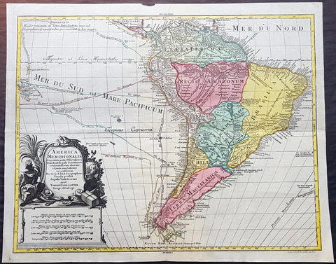
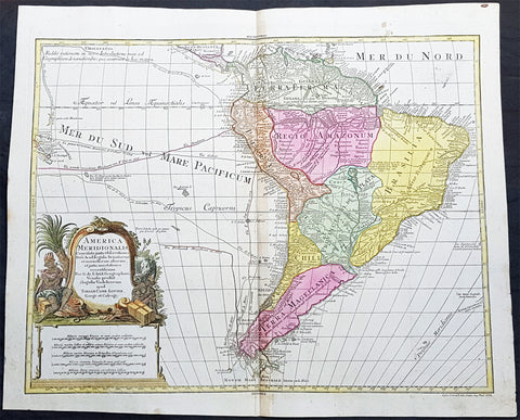
1772 Tobias Lotter Large Antique Map of South America, Drake, Magellan, Le Maire
- Title : America Meridionalis ...Tobiam Conr. Lotter...1772
- Date : 1772
- Size: 25 1/2in x 21in (650mm x 535mm)
- Ref #: 70819
- Condition: (A+) Fine Condition
Description:
This large original beautifully hand coloured copper plate engraved antique map of South America was engraved by Gustav Conrad Lotter in 1772 - dated at the foot of the map - and published by his father Tobias Conrad Lotter.
The map shows the routes of the voyages by various famous explorers to South America including: Magellan (1520), Drake (1577), le Maire & Schouten (1616), Sarmineto (1570) and others. The map also illustrates various river systems and other speculative information about the unexplored interior of the Continent. (Ref: Tooley, M&B)
General Definitions:
Paper thickness and quality: - Heavy and stable
Paper color : - off white
Age of map color: - Original
Colors used: - Blue, pink, red, green, yellow
General color appearance: - Authentic
Paper size: - 25 1/2in x 21in (650mm x 535mm)
Plate size: - 23 1/2in x 19 1/2in (595mm x 495mm)
Margins: - Min 1in (25mm)
Imperfections:
Margins: - None
Plate area: - None
Verso: - None
Background:
In 1494, Portugal and Spain, the two great maritime European powers of that time, on the expectation of new lands being discovered in the west, signed the Treaty of Tordesillas, by which they agreed, with the support of the Pope, that all the land outside Europe should be an exclusive duopoly between the two countries.
The treaty established an imaginary line along a north-south meridian 370 leagues west of the Cape Verde Islands, roughly 46° 37\\\\\\\\\\\\\\\\\\\\\\\\\\\\\\\\\\\\\\\\\\\\\\\\\\\\\\\\\\\\\\\' W. In terms of the treaty, all land to the west of the line (known to comprise most of the South American soil) would belong to Spain, and all land to the east, to Portugal. As accurate measurements of longitude were impossible at that time, the line was not strictly enforced, resulting in a Portuguese expansion of Brazil across the meridian.
Beginning in the 1530s, the people and natural resources of South America were repeatedly exploited by foreign conquistadors, first from Spain and later from Portugal. These competing colonial nations claimed the land and resources as their own and divided it in colonies.
European infectious diseases (smallpox, influenza, measles, and typhus) – to which the native populations had no immune resistance – caused large-scale depopulation of the native population under Spanish control. Systems of forced labor, such as the haciendas and mining industry\\\\\\\\\\\\\\\\\\\\\\\\\\\\\\\\\\\\\\\\\\\\\\\\\\\\\\\\\\\\\\\'s mita also contributed to the depopulation. After this, African slaves, who had developed immunities to these diseases, were quickly brought in to replace them.
The Spaniards were committed to converting their native subjects to Christianity and were quick to purge any native cultural practices that hindered this end; however, many initial attempts at this were only partially successful, as native groups simply blended Catholicism with their established beliefs and practices. Furthermore, the Spaniards brought their language to the degree they did with their religion, although the Roman Catholic Churchs evangelization in Quechua, Aymara, and Guaraní actually contributed to the continuous use of these native languages albeit only in the oral form.
Eventually, the natives and the Spaniards interbred, forming a mestizo class. At the beginning, many mestizos of the Andean region were offspring of Amerindian mothers and Spanish fathers. After independence, most mestizos had native fathers and European or mestizo mothers.
Many native artworks were considered pagan idols and destroyed by Spanish explorers; this included many gold and silver sculptures and other artifacts found in South America, which were melted down before their transport to Spain or Portugal. Spaniards and Portuguese brought the western European architectural style to the continent, and helped to improve infrastructures like bridges, roads, and the sewer system of the cities they discovered or conquered. They also significantly increased economic and trade relations, not just between the old and new world but between the different South American regions and peoples. Finally, with the expansion of the Portuguese and Spanish languages, many cultures that were previously separated became united through that of Latin American.
Guyana was first a Dutch, and then a British colony, though there was a brief period during the Napoleonic Wars when it was colonized by the French. The country was once partitioned into three parts, each being controlled by one of the colonial powers until the country was finally taken over fully by the British.
The European Peninsular War (1807–1814), a theater of the Napoleonic Wars, changed the political situation of both the Spanish and Portuguese colonies. First, Napoleon invaded Portugal, but the House of Braganza avoided capture by escaping to Brazil. Napoleon also captured King Ferdinand VII of Spain, and appointed his own brother instead. This appointment provoked severe popular resistance, which created Juntas to rule in the name of the captured king.
Many cities in the Spanish colonies, however, considered themselves equally authorized to appoint local Juntas like those of Spain. This began the Spanish American wars of independence between the patriots, who promoted such autonomy, and the royalists, who supported Spanish authority over the Americas. The Juntas, in both Spain and the Americas, promoted the ideas of the Enlightenment. Five years after the beginning of the war, Ferdinand VII returned to the throne and began the Absolutist Restoration as the royalists got the upper hand in the conflict.
The independence of South America was secured by Simón Bolívar (Venezuela) and José de San Martín (Argentina), the two most important Libertadores. Bolívar led a great uprising in the north, then led his army southward towards Lima, the capital of the Viceroyalty of Peru. Meanwhile, San Martín led an army across the Andes Mountains, along with Chilean expatriates, and liberated Chile. He organized a fleet to reach Peru by sea, and sought the military support of various rebels from the Vice-royalty of Peru. The two armies finally met in Guayaquil, Ecuador, where they cornered the Royal Army of the Spanish Crown and forced its surrender.
In the Portuguese Kingdom of Brazil, Dom Pedro I (also Pedro IV of Portugal), son of the Portuguese King Dom João VI, proclaimed the independent Kingdom of Brazil in 1822, which later became the Empire of Brazil. Despite the Portuguese loyalties of garrisons in Bahia, Cisplatina and Pará, independence was diplomatically accepted by the crown in Portugal in 1825, on condition of a high compensation paid by Brazil mediatized by the United Kingdom.
1772 Tobias Lotter Large Antique Map of South America, Magellan, Drake, Le Maire
- Title : America Meridionalis ...Tobiam Conr. Lotter...1772
- Date : 1772
- Size: 25 1/2in x 21in (650mm x 535mm)
- Ref #: 61139
- Condition: (A+) Fine Condition
Description:
This large original beautifully hand coloured copper plate engraved antique map of South America was engraved by Gustav Conrad Lotter in 1772 - dated at the foot of the map - and published by his father Tobias Conrad Lotter.
The map shows the routes of the voyages by various famous explorers to South America including: Magellan (1520), Drake (1577), le Maire & Schouten (1616), Sarmineto (1570) and others. The map also illustrates various river systems and other speculative information about the unexplored interior of the Continent. (Ref: Tooley, M&B)
General Definitions:
Paper thickness and quality: - Heavy and stable
Paper color : - off white
Age of map color: - Original
Colors used: - Blue, pink, red, green, yellow
General color appearance: - Authentic
Paper size: - 25 1/2in x 21in (650mm x 535mm)
Plate size: - 23 1/2in x 19 1/2in (595mm x 495mm)
Margins: - Min 1in (25mm)
Imperfections:
Margins: - None
Plate area: - None
Verso: - None
Background:
In 1494, Portugal and Spain, the two great maritime European powers of that time, on the expectation of new lands being discovered in the west, signed the Treaty of Tordesillas, by which they agreed, with the support of the Pope, that all the land outside Europe should be an exclusive duopoly between the two countries.
The treaty established an imaginary line along a north-south meridian 370 leagues west of the Cape Verde Islands, roughly 46° 37\\\\\\\\\\\\\\\\\\\\\\\\\\\\\\\\\\\\\\\\\\\\\\\\\\\\\\\\\\\\\\\' W. In terms of the treaty, all land to the west of the line (known to comprise most of the South American soil) would belong to Spain, and all land to the east, to Portugal. As accurate measurements of longitude were impossible at that time, the line was not strictly enforced, resulting in a Portuguese expansion of Brazil across the meridian.
Beginning in the 1530s, the people and natural resources of South America were repeatedly exploited by foreign conquistadors, first from Spain and later from Portugal. These competing colonial nations claimed the land and resources as their own and divided it in colonies.
European infectious diseases (smallpox, influenza, measles, and typhus) – to which the native populations had no immune resistance – caused large-scale depopulation of the native population under Spanish control. Systems of forced labor, such as the haciendas and mining industry\\\\\\\\\\\\\\\\\\\\\\\\\\\\\\\\\\\\\\\\\\\\\\\\\\\\\\\\\\\\\\\'s mita also contributed to the depopulation. After this, African slaves, who had developed immunities to these diseases, were quickly brought in to replace them.
The Spaniards were committed to converting their native subjects to Christianity and were quick to purge any native cultural practices that hindered this end; however, many initial attempts at this were only partially successful, as native groups simply blended Catholicism with their established beliefs and practices. Furthermore, the Spaniards brought their language to the degree they did with their religion, although the Roman Catholic Churchs evangelization in Quechua, Aymara, and Guaraní actually contributed to the continuous use of these native languages albeit only in the oral form.
Eventually, the natives and the Spaniards interbred, forming a mestizo class. At the beginning, many mestizos of the Andean region were offspring of Amerindian mothers and Spanish fathers. After independence, most mestizos had native fathers and European or mestizo mothers.
Many native artworks were considered pagan idols and destroyed by Spanish explorers; this included many gold and silver sculptures and other artifacts found in South America, which were melted down before their transport to Spain or Portugal. Spaniards and Portuguese brought the western European architectural style to the continent, and helped to improve infrastructures like bridges, roads, and the sewer system of the cities they discovered or conquered. They also significantly increased economic and trade relations, not just between the old and new world but between the different South American regions and peoples. Finally, with the expansion of the Portuguese and Spanish languages, many cultures that were previously separated became united through that of Latin American.
Guyana was first a Dutch, and then a British colony, though there was a brief period during the Napoleonic Wars when it was colonized by the French. The country was once partitioned into three parts, each being controlled by one of the colonial powers until the country was finally taken over fully by the British.
The European Peninsular War (1807–1814), a theater of the Napoleonic Wars, changed the political situation of both the Spanish and Portuguese colonies. First, Napoleon invaded Portugal, but the House of Braganza avoided capture by escaping to Brazil. Napoleon also captured King Ferdinand VII of Spain, and appointed his own brother instead. This appointment provoked severe popular resistance, which created Juntas to rule in the name of the captured king.
Many cities in the Spanish colonies, however, considered themselves equally authorized to appoint local Juntas like those of Spain. This began the Spanish American wars of independence between the patriots, who promoted such autonomy, and the royalists, who supported Spanish authority over the Americas. The Juntas, in both Spain and the Americas, promoted the ideas of the Enlightenment. Five years after the beginning of the war, Ferdinand VII returned to the throne and began the Absolutist Restoration as the royalists got the upper hand in the conflict.
The independence of South America was secured by Simón Bolívar (Venezuela) and José de San Martín (Argentina), the two most important Libertadores. Bolívar led a great uprising in the north, then led his army southward towards Lima, the capital of the Viceroyalty of Peru. Meanwhile, San Martín led an army across the Andes Mountains, along with Chilean expatriates, and liberated Chile. He organized a fleet to reach Peru by sea, and sought the military support of various rebels from the Vice-royalty of Peru. The two armies finally met in Guayaquil, Ecuador, where they cornered the Royal Army of the Spanish Crown and forced its surrender.
In the Portuguese Kingdom of Brazil, Dom Pedro I (also Pedro IV of Portugal), son of the Portuguese King Dom João VI, proclaimed the independent Kingdom of Brazil in 1822, which later became the Empire of Brazil. Despite the Portuguese loyalties of garrisons in Bahia, Cisplatina and Pará, independence was diplomatically accepted by the crown in Portugal in 1825, on condition of a high compensation paid by Brazil mediatized by the United Kingdom.
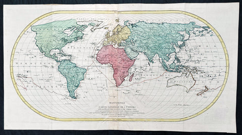
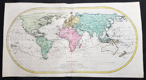
1778 Matthaus Lotter Large Oval World Map showing Capt Cooks 1st Voyage - Rare 1st edition
- Title : Mappe Monde ou carte generale de l`Univers sur une projection nouvelle d`une sphere ovale pour mieux entendre les distances entre l`Europe et Amerique avec le tour du monde du Lieut Cook et Tous Les Decouvertes Nouvelles...MDCCLXXVIII
- Date : 1778 (1st edition)
- Condition: (A+) Fine Condition
- Ref: 35629
- Size: 39in x 21in (990mm x 535mm)
Description:
This very large, impressive original copper-plate engraved antique World Map, on an Ortelius Oval Projection, showing the tracks of Captain Cooks 1st Voyage to the South Seas, was engraved and published by Matthäus Albrecht Lotter in 1778, dated in title. The map was re-issued in 1782 & 1787 to include the tracks of Cooks 2nd & 3rd voyages of discovery.
This 1st edition Lotter Oval map is scarce with only a small few available on the open market.
This map was one of the first world maps published to cash in on the publicity over Captain James Cooks Circumnavigation of the world and the first European survey of New Zealand and the East Coast of Australia. Beautifully executed and dominated by New Holland, Australia, for the first time almost complete on a world map.
General Definitions:
Paper thickness and quality: - Heavy and stable
Paper color : - off white
Age of map color: - Original
Colors used: - Yellow, green, pink
General color appearance: - Authentic
Paper size: - 39in x 21in (990mm x 535mm)
Plate size: - 37 1/2in x 19 1/4in (955mm x 495mm)
Margins: - Min 1in (25mm)
Imperfections:
Margins: - None
Plate area: - Folds as issued
Verso: - None
Background:
This large world map was one of the first to show the discoveries of the east coast of Australia and New Zealand by James Cook on his first voyage of Discovery. The shadow line from Tasmania west to Western Australia was not filled in until the later discoveries of Bass Strait by Bass and Matthew Flinders in 1797 and the southern coast by Baudin and Flinders in 1803. Also included along the New Holland coastline is the earlier Dutch discoveries of Hartog 1616, the van Leeuwin 1619, Nuyts 1627, de Wit 1628 and Tasman 1642-44. The Trial Islands near present-day Dampier, named after the English ship the Trial, which were incorrectly charted by Gerritsz after the false reports provided by Captain Brookes, are also noted.
Cooks First Voyage (1768-1771)
The first voyage under Captain James Cooks command was primarily of a scientific nature. The expedition on HMS Endeavour initially sailed to Tahiti to observe the transit of the planet Venus in order to calculate the earths distance from the sun. Cook landed on the South Pacific island in April of 1769 and in June of that year the astronomical observations were successfully completed. In addition to these labors, very good relations with the Tahitians were maintained and the naturalists Joseph Banks and Daniel C. Solander conducted extensive ethnological and botanical research.
Another purpose of the voyage was to explore the South Seas to determine if an inhabitable continent existed in the mid-latitudes of the Southern Hemisphere. Upon leaving Tahiti, Cook named and charted the Society Islands and then continued southwest to New Zealand. His circumnavigation and exploration of that country also resulted in a detailed survey. Cook proceeded to Australia, where he charted the eastern coast for 2,000 miles, naming the area New South Wales. As a result of these surveys, both Australia and New Zealand were annexed by Great Britain. In addition to these explorations, the HMS Endeavour returned to England without a single death from scurvy among its men, an historic feat at the time. The combination of these accomplishments brought Cook prominence, promotion, and the opportunity to lead further expeditions.
The Ortelius Oval Projection is a map projection used for world maps largely in the late 16th and early 17th century. It is neither conformal nor equal-area but instead offers a compromise presentation. It is similar in structure to a pseudocylindrical projection but does not qualify as one because the meridians are not equally spaced along the parallels. The projection\'s first known use was by Battista Agnese (flourished 1535–1564) around 1540, although whether the construction method was truly identical to Ortelius\'s or not is unclear because of crude drafting and printing. The front hemisphere is identical to Petrus Apianus\'s 1524 globular projection.
The projection reached a wide audience via the popular map Typus Orbis Terrarum by Abraham Ortelius beginning in 1570. The projection (and indeed Ortelius maps) were widely copied by other mapmakers such as Giovanni Pietro Maffei, Fernando de Solis, and Matteo Ricci.
1778 Matthäus Lotter Large Oval World Map showing Capt Cooks 1st Voyage - Rare 1st edition
- Title : Mappe Monde ou carte generale de l`Univers sur une projection nouvelle d`une sphere ovale pour mieux entendre les distances entre l`Europe et Amerique avec le tour du monde du Lieut Cook et Tous Les Decouvertes Nouvelles...MDCCLXXVIII
- Date : 1778
- Condition: (A+) Fine Condition
- Ref: 93515
- Size: 39in x 21in (990mm x 535mm)
- Price: $2499US
Description:
This very large, impressive original copper-plate engraved antique World Map, on an Ortelius Oval Projection, showing the tracks of Captain Cooks 1st Voyage to the South Seas, was engraved and published by Matthäus Albrecht Lotter in 1778, dated in title. The map was re-issued in 1782 & 1787 to include the tracks of Cooks 2nd & 3rd voyages of discovery.
This 1st edition Lotter Oval map is scarce with only a small few available on the open market.
This map was one of the first world maps published to cash in on the publicity over Captain James Cooks Circumnavigation of the world and the first European survey of New Zealand and the East Coast of Australia. Beautifully executed and dominated by New Holland, Australia, for the first time almost complete on a world map.
General Definitions:
Paper thickness and quality: - Heavy and stable
Paper color : - off white
Age of map color: - Original
Colors used: - Yellow, green, pink
General color appearance: - Authentic
Paper size: - 39in x 21in (990mm x 535mm)
Plate size: - 37 1/2in x 19 1/4in (955mm x 495mm)
Margins: - Min 1in (25mm)
Imperfections:
Margins: - None
Plate area: - None
Verso: - None
Background:
This large world map was one of the first to show the discoveries of the east coast of Australia and New Zealand by James Cook on his first voyage of Discovery. The shadow line from Tasmania west to Western Australia was not filled in until the later discoveries of Bass Strait by Bass and Matthew Flinders in 1797 and the southern coast by Baudin and Flinders in 1803. Also included along the New Holland coastline is the earlier Dutch discoveries of Hartog 1616, the van Leeuwin 1619, Nuyts 1627, de Wit 1628 and Tasman 1642-44. The Trial Islands near present-day Dampier, named after the English ship the Trial, which were incorrectly charted by Gerritsz after the false reports provided by Captain Brookes, are also noted.
Cooks First Voyage (1768-1771)
The first voyage under Captain James Cooks command was primarily of a scientific nature. The expedition on HMS Endeavour initially sailed to Tahiti to observe the transit of the planet Venus in order to calculate the earths distance from the sun. Cook landed on the South Pacific island in April of 1769 and in June of that year the astronomical observations were successfully completed. In addition to these labors, very good relations with the Tahitians were maintained and the naturalists Joseph Banks and Daniel C. Solander conducted extensive ethnological and botanical research.
Another purpose of the voyage was to explore the South Seas to determine if an inhabitable continent existed in the mid-latitudes of the Southern Hemisphere. Upon leaving Tahiti, Cook named and charted the Society Islands and then continued southwest to New Zealand. His circumnavigation and exploration of that country also resulted in a detailed survey. Cook proceeded to Australia, where he charted the eastern coast for 2,000 miles, naming the area New South Wales. As a result of these surveys, both Australia and New Zealand were annexed by Great Britain. In addition to these explorations, the HMS Endeavour returned to England without a single death from scurvy among its men, an historic feat at the time. The combination of these accomplishments brought Cook prominence, promotion, and the opportunity to lead further expeditions.
The Ortelius Oval Projection is a map projection used for world maps largely in the late 16th and early 17th century. It is neither conformal nor equal-area but instead offers a compromise presentation. It is similar in structure to a pseudocylindrical projection but does not qualify as one because the meridians are not equally spaced along the parallels. The projection\'s first known use was by Battista Agnese (flourished 1535–1564) around 1540, although whether the construction method was truly identical to Ortelius\'s or not is unclear because of crude drafting and printing. The front hemisphere is identical to Petrus Apianus\'s 1524 globular projection.
The projection reached a wide audience via the popular map Typus Orbis Terrarum by Abraham Ortelius beginning in 1570. The projection (and indeed Ortelius maps) were widely copied by other mapmakers such as Giovanni Pietro Maffei, Fernando de Solis, and Matteo Ricci.
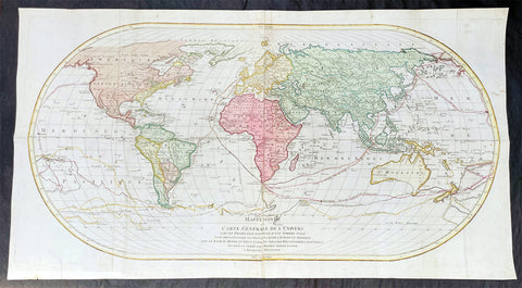
1782 Matthaus Lotter Large World Map Tracking of Cooks Voyages 1768, 1772 & 1776
- Title : Mappe Monde ou carte generale de l`Univers sur une projection nouvelle d`une sphere ovale pour mieux entendre les distances entre l`Europe et Amerique avec le tour du monde du Lieut Cook et Tous Les Decouvertes Nouvelles...MDCCLXXXII
- Date : 1782 (2nd edition)
- Condition: (A) Very Good Condition
- Ref: 35646
- Size: 38 1/2in x 21in (985mm x 535mm)
Description:
This very large, impressive original copper-plate engraved antique World Map, on an Ortelius Oval Projection, was engraved and published by Matthäus Albrecht Lotter in 1782, dated in title.
The map was first issued in 1778 and re-issued in 1782 & 1787 and included all three of Cooks voyages of discovery.
This map was one of the first world maps published to cash in on the publicity over Captain James Cooks Circumnavigation of the world and the first European survey of New Zealand and the East Coast of Australia. Beautifully executed and dominated by New Holland, Australia, for the first time almost complete on a world map.
General Definitions:
Paper thickness and quality: - Heavy and stable
Paper color : - off white
Age of map color: - Original
Colors used: - Yellow, green, pink
General color appearance: - Authentic
Paper size: - 38 1/2in x 21in (985mm x 535mm)
Plate size: - 37 1/2in x 19 1/4in (955mm x 495mm)
Margins: - Min 1in (25mm)
Imperfections:
Margins: - Folds as issue, light soiling
Plate area: - Folds as issue, light soiling
Verso: - Folds as issue, light soiling
Background:
This large world map was one of the first to show the discoveries of the east coast of Australia and New Zealand by James Cook on his first voyage of Discovery. The shadow line from Tasmania west to Western Australia was not filled in until the later discoveries of Bass Strait by Bass and Matthew Flinders in 1797 and the southern coast by Baudin and Flinders in 1803. Also included along the New Holland coastline is the earlier Dutch discoveries of Hartog 1616, the van Leeuwin 1619, Nuyts 1627, de Wit 1628 and Tasman 1642-44. The Trial Islands near present-day Dampier, named after the English ship the Trial, which were incorrectly charted by Gerritsz after the false reports provided by Captain Brookes, are also noted.
Cooks First Voyage (1768-1771)
The first voyage under Captain James Cook\\\\\\\'s command was primarily of a scientific nature. The expedition on the Endeavour initially sailed to Tahiti to observe the transit of the planet Venus in order to calculate the earth\\\\\\\'s distance from the sun. Cook landed on the South Pacific island in April of 1769 and in June of that year the astronomical observations were successfully completed. In addition to these labors, very good relations with the Tahitians were maintained and the naturalists Joseph Banks and Daniel C. Solander conducted extensive ethnological and botanical research.
Another purpose of the voyage was to explore the South Seas to determine if an inhabitable continent existed in the mid-latitudes of the Southern Hemisphere. Upon leaving Tahiti, Cook named and charted the Society Islands and then continued southwest to New Zealand. His circumnavigation and exploration of that country also resulted in a detailed survey. Cook proceeded to Australia, where he charted the eastern coast for 2,000 miles, naming the area New South Wales. As a result of these surveys, both Australia and New Zealand were annexed by Great Britain. In addition to these explorations, the Endeavour returned to England without a single death from scurvy among its men, an historic feat at the time. The combination of these accomplishments brought Cook prominence, promotion, and the opportunity to lead further expeditions.
Cooks Second Voyage (1772-1775)
Based on the success of his first voyage, Cook was appointed by the Admiralty to lead a second expedition. Two ships were employed with Cook commanding the Resolution and Captain Tobias Furneaux in charge of the Adventure. The purpose was to circumnavigate the globe as far south as possible to confirm the location of a southern continent. Cook proved that there was no Terra Australis, which supposedly was located between New Zealand and South America. Cook was convinced, however, that there was land beyond the southern ice fields. In his pursuit of this idea, this expedition was the first European voyage to cross the Antarctic Circle. In addition, in two great sweeps through the Southern latitudes, Cook made an incredible number of landfalls including New Zealand, Easter Island, the Marquesas, Tahiti and the Society Islands, the Tonga Islands, the New Hebrides, New Caledonia, and a number of smaller islands.
In addition to these navigational accomplishments and the accompanying expansion of geographical knowledge, the expedition also recorded a vast amount of information regarding the Pacific islands and peoples, proved the value of the chronometer as an instrument for calculating longitude, and improved techniques for preventing scurvy.
Cooks Third Voyage (1776-1779)
In the course of his first two voyages, Cook circumnavigated the globe twice, sailed extensively into the Antarctic, and charted coastlines from Newfoundland to New Zealand. Following these achievements, Cooks third voyage was organized to seek an efficient route from England to southern and eastern Asia that would not entail rounding the Cape of Good Hope. The search for such a Northwest (or Northeast) Passage had been on the agenda of northern European mariners and merchants since the beginning of European expansion in the late fifteenth century. England\\\\\\\'s growing economic and colonial interests in India in the later eighteenth century provided the stimulus for the latest exploration for this route.
Cook, again in command of the Resolution, was to approach the Northwest Passage from the Pacific accompanied by a second ship, the Discovery, captained by Charles Clerke. The ships left England separately, regrouped at Cape Town, and continued on to Tasmania, New Zealand, and Tahiti. The expedition then sailed north and made landfall at Christmas Island and the Hawaiian Islands. Cook continued northward and charted the west coast of North America from Northern California as far as the Bering Strait. He returned to Hawaii for the winter and was killed in a skirmish with natives on February 14, 1779. Upon Cooks death, Clerke took command of the expedition but died six months later. The ships returned to England in 1780 under John Gore, who had commanded the Discovery after Cooks death. From start to finish, the voyage had lasted more than four years. (Ref Tooley; M&B; Clancy)
The Ortelius Oval Projection is a map projection used for world maps largely in the late 16th and early 17th century. It is neither conformal nor equal-area but instead offers a compromise presentation. It is similar in structure to a pseudocylindrical projection but does not qualify as one because the meridians are not equally spaced along the parallels. The projection\'s first known use was by Battista Agnese (flourished 1535–1564) around 1540, although whether the construction method was truly identical to Ortelius\'s or not is unclear because of crude drafting and printing. The front hemisphere is identical to Petrus Apianus\'s 1524 globular projection.
The projection reached a wide audience via the popular map Typus Orbis Terrarum by Abraham Ortelius beginning in 1570. The projection (and indeed Ortelius maps) were widely copied by other mapmakers such as Giovanni Pietro Maffei, Fernando de Solis, and Matteo Ricci.