Robert De Vaugondy (1688 - 1766) & Didier Robert de Vaugondy (c.1723–1786)
Profile :
Gilles and Didier Robert De Vaugondy were father and son, respectively, and produced their atlas, globes and maps in concert with others such as Sanson, Jaillot and Bonne amongst others. In many cases they did not use the initials of their first names when signing their maps, so it can be unclear at times who made a given map. On some maps fils. or filio. follows the name, designating its author as the son. In other instances, the authorship can be determined by the distinctive way each signed his maps: the father normally used "M.Robert," leaving off the last name, and the son, "Robert de Vaugondy." The Atlas Universal [Paris, 1757] was one of the most important 18th century atlases and one of the great achievements of the French Enlightenment.
The Vaugondy's employed strict standards for including maps in this atlas and in many cases subjected them to astronomically derived readings for latitude and longitude. Moreover, 'their frequent use of eighteenth century sources, often from the 1740s, provided their atlas with up-to-date information. While their preference was for maps that bad been surveyed in the field and maps published in the region itself, they did not hesitate to turn to older sources when more recent maps were found to be lacking." (Pedley, p. 61)
For their maps of Canada and South America, the Vaugondy's had access to sources held by the Depot de la Marine, the official French repository for maritime-related information. Like Ortelius and Mercator before them, the Vaugondy`s listed the sources of their maps, which is of incalculable benefit to anyone seeking to understand not only their maps but also those of the period.
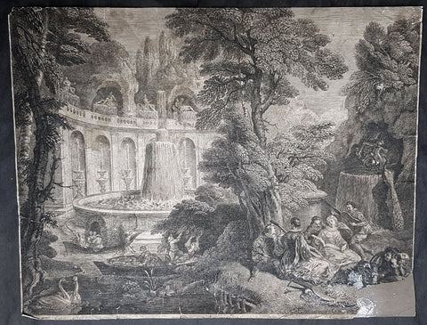
"A feature of the maps of the Atlas Universel which attracted unanimous praise from critics was the cartouches." (Pedley, p. 64) A number of artisans worked on their design and engraving; several cartouches were engraved and signed by the Haussard sisters. Among the most pictorial cartouches are the four found on maps showing the postal routes of Great Britain, France, Germany, Spain and Portugal. They depict postal carriers en route in richly detailed settings.
Robert De Vaugondy (14)
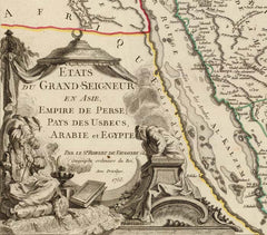
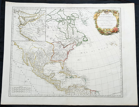
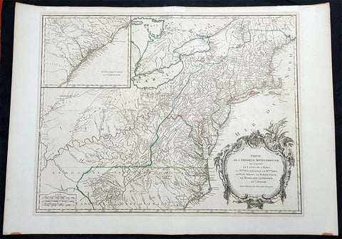
1755 Robert De Vaugondy Large Antique 1st edition Map of Colonial United States
- Title : Partie De L Amerique Septentrionale, qui Comprend Le Cours De L Ohio...1755
- Ref #: 93003
- Size: 28in x 21 1/2in (710mm x 550mm)
- Date : 1755
- Condition: (A+) Fine Condition
Description:
This large, beautifully hand coloured, scarce 1st state, original antique map of the east coast of the United States, illustrating the course of the Ohio River and stretching from New England to the Carolinas, west to the Great Lakes and south to the Mississippi - with an inset map of The Carolinas, was engraved in 1755 - the date is engraved in the title cartouche - and published by Robert Du Vaugondy in his Atlas Universal, Paris 1757.
This is one of the finest examples of this map I have seen to date. Beautiful hand colour on age toned heavy paper with original margins with a heavy dark ink denoting a very early pressing.
At the time of listing there are 2 examples of this 1st state map for sale on the web at $1600 & 1800 respectively.
General Definitions:
Paper thickness and quality: - Heavy and stable
Paper color : - off white
Age of map color: - Original
Colors used: - Blue, pink, red, green, yellow
General color appearance: - Authentic
Paper size: - 28in x 21 1/2in (710mm x 550mm)
Plate size: - 24 1/2in x 19 1/2in (620mm x 495mm)
Margins: - Min 1in (25mm)
Imperfections:
Margins: - None
Plate area: - None
Verso: - None
Background:
First state of the beautiful and early de Vaugondy map of the British colonies, based upon John Mitchell\'s great map of North America from the same year, also drawing from Lewis, Evans on the Middle British Colonies and Joshua Fry\'s and Peter Jefferson\'s map of Virginia and Maryland. The Mitchell map was the culmination of many years of British surveying in the North American Colonies and was considered one of the best maps of the continent available to Europeans and Americans in the mid-eighteenth century.
De Vaugondy\'s rendition does not copy the full scope of Mitchell\'s map but instead focuses on the colonies stretching from southern Maine to the Carolinas. In the top left corner is an inset of South Carolina and Georgia. De Vaugondy also pays special attention to the river systems and settlements. This map shows some of the earliest accurate information of the trans-Allegheny regions (the Ohio River, Kentucky, Tennessee and Parts of Ohio) and inland areas to the southeast of the Great Lakes and interior of New England. The dotted lines and outline color designate pre-Treaty of Paris (1763) information about the Ohio country.
Maine is still part of the Massachusetts Bay Colony. During this era, a dispute arose between New Hampshire and New York over who controlled the area which is now Vermont. Here, New York is shown as to contain Vermont within its borders. The outbreak of the French & Indian War (Seven Years War) briefly suspended interest in the disputed area, and it was not until 1764 that the British crown upheld New York\'s claim to Vermont. The western borders of the British Colonies extend only to the Appalachians, with the exception of \"Caroline, \"which extends slightly further west. This shows the strong French presence along the western frontier in the days leading up to the French & Indian conflict. Pennsylvania is shown to stretch north almost to Lake Ontario and encompass much of western New York.
Included is a beautiful title cartouche in the Rococo style. (Ref: Tooley; M&B)
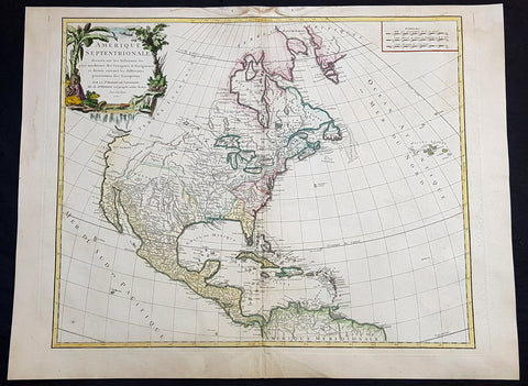
1750 Robert De Vaugondy Large Antique Map of Colonial North America, 1st Edition
- Title : Amérique Septentrionale, dressée, sur les Relations les plus modernes des Voyageurs et Navigateurs, et divisée suivant les differentes possessions des Européens...Par Le Sr Robert De Vaugondy 1750 [North America, drawn from the most recent accounts of the Voyagers and Navigators, and divided according to the different possessions of the Europeans...Robert De Vaugondy 1750
- Date : 1750
- Condition: (A+) Fine Condition
- Ref: 93048
- Size: 30 1/2in x 21 1/2in (775mm x 545mm)
Description:
This large beautifully hand coloured original 1st edition antique map of North America by Robert De Vaugondy in 1750 - dated in cartouche - was published in the 1757 edition of Atlas Universel, one of the most important atlases of the 18th century.
A beautifully executed & iconic mid 18th century antique map of the entire continent of North America, from Arctic Canada to Central America.
This map is a must for any American map collection. Beautiful original hand colour, a heavy impression (denoting an early pressing) on heavy sturdy paper with original margins, an exciting map .
General Definitions:
Paper thickness and quality: - Heavy and stable
Paper color : - off white
Age of map color: - Original
Colors used: - Yellow, green, blue, pink
General color appearance: - Authentic
Paper size: - 30 1/2in x 21 1/2in (775mm x 545mm)
Plate size: - 25in x 19 1/2in (635mm x 495mm)
Margins: - Min 1in (25mm)
Imperfections:
Margins: - None
Plate area: - None
Verso: - None
Background:
This attractive map depicts a fascinating period time in the history of North America, immediately before the French and Indian War. The British Thirteen Colonies hug the Atlantic seaboard, while the immense Gallic empire, embracing both New France (Canada) and Louisiana (the Mississippi Basin) occupy the majority of the interior of the continent. This highly detailed map labels numerous native villages and European forts in the interior of the continent. Spanish Mexico reaches all the way north to modern-day Colorado, and Baja California is shown accurately to be a peninsula, and not an island as previously thought. The Pacific Northwest remains entirely enigmatic, labelled as the Terres Inconnues. The map also depicts the islands of the Caribbean, which are shown to be in the possession of the various European powers. Vaugondy consulted several sources in devising his map including Bellins excellent rendering of the Great Lakes, and Guillame De L Isles and Jean-Baptiste D\'Anvilles maps of the Mississippi Basin. The composition is graced by an elegant title cartouche featuring a waterfall inhabited by a cayman, and framed by coulisses of palm trees accompanied by native Americans.
1785 De Vaugondy & Jefferson Antique Early Map of The United States of America
- Title : Etats-Unis de l'Amerique Septentrionale avec les Isles Royale, de Terre Neuve de St. Jean, l'Acadie &c. 1785 M. Robert de Vaugondy....Boudet....
- Date : 1785
- Condition: (A+) Fine Condition
- Ref: 93513
- Size: 26in x 20 1/2in (660mm x 520mm)
Description:
This large original hand coloured copper-plate engraved very important, early & scarce antique early map of the United States (Etats-Unis De L Amerique), during what is know as the Confederation Period, by Robert De Vaugondy was published by the French printer Antoine Boudet (1715 - 1787) for the supplement of de Vaugondys Atlas Universal
This scarce first state map is very important to the formation of the United States of America. The map is the first to describe what is know as the Jeffersonian Ordinance, showing the new international borders of the fledgling United States, the inclusion of the original 13 states in the bottom right text box (the first map to do so) along with the inclusion of Michigan, ratified under the Treaty of Paris in 1783.
The successor to De Vaugondy, Charles Francois Delamarche (1740 - 1817) was a known correspondent to Thomas Jefferson and along with the printer Boudet would have played an important part in the publication of this map. The Ordinance of 1784 was a plan to outline the new territories and states, that would eventually make up the foundation of the United States, ratified by the Treaty of Paris. Given that this map was engraved in 1785 or possibly earlier and that Delamarche was a friend of Jefferson, it is not a stretch to believe that he was one of the first, if not the first, to map the new country of the United States (Etats-Unis De L Amerique)
General Definitions:
Paper thickness and quality: - Heavy and stable
Paper color : - off white
Age of map color: - Original
Colors used: - Yellow, green, blue, pink
General color appearance: - Authentic
Paper size: - 26 1/2in x 20 1/2in (670mm x 520mm)
Plate size: - 25 1/2in x 19 1/2in (650mm x 500mm)
Margins: - Min 1/2in (12mm)
Imperfections:
Margins: - Light age toning in margins
Plate area: - Light creasing along centerfold
Verso: - None
Background:
The Confederation Period was the era of United States history in the 1780s after the American Revolution and prior to the ratification of the United States Constitution. In 1781, the United States ratified the Articles of Confederation and prevailed in the Battle of Yorktown, the last major land battle between British and American forces in the American Revolutionary War. American independence was confirmed with the 1783 signing of the Treaty of Paris. The fledgling United States faced several challenges, many of which stemmed from the lack of a strong national government and unified political culture. The period ended in 1789 following the ratification of the United States Constitution, which established a new, more powerful, national government.
The Articles of Confederation established a loose confederation of states with a weak federal government. An assembly of delegates acted on behalf of the states they represented. This unicameral body, officially referred to as the United States in Congress Assembled, had little authority, and could not accomplish anything independent of the states. It had no chief executive, and no court system. Congress lacked the power to levy taxes, regulate foreign or interstate commerce, or effectively negotiate with foreign powers. The weakness of Congress proved self-reinforcing, as the leading political figures of the day served in state governments or foreign posts. The failure of the national government to handle the challenges facing the United States led to calls for reform and frequent talk of secession.
The Treaty of Paris left the United States with a vast territory spanning from the Atlantic Ocean to the Mississippi River. Settlement of the trans-Appalachian territories proved difficult, in part due to the resistance of Native Americans and the neighboring foreign powers of Great Britain and Spain. The British refused to evacuate US territory, while the Spanish used their control of the Mississippi River to stymie Western settlement. In 1787, Congress passed the Northwest Ordinance, which set an important precedent by establishing the first organized territory under the control of the national government.
After Congressional efforts to amend the Articles failed, numerous national leaders met in Philadelphia in 1787 to establish a new constitution. The new constitution was ratified in 1788, and the new federal government began meeting in 1789, marking the end of the Confederation Period. Some historians believe that the 1780s were a bleak, terrible time for the US, while others have argued that the period was actually stable and relatively prosperous.
1750 Robert De Vaugondy Large Antique Map of Colonial North America, 1st Edition
- Title : Amérique Septentrionale, dressée, sur les Relations les plus modernes des Voyageurs et Navigateurs, et divisée suivant les differentes possessions des Européens...Par Le Sr Robert De Vaugondy 1750 [North America, drawn from the most recent accounts of the Voyagers and Navigators, and divided according to the different possessions of the Europeans...Robert De Vaugondy 1750
- Date : 1750
- Condition: (A+) Fine Condition
- Ref: 93358
- Size: 27 1/2in x 21in (700mm x 535mm)
Description:
This large beautifully hand coloured original 1st edition antique map of North America by Robert De Vaugondy in 1750 - dated in cartouche - was published in the 1757 edition of Atlas Universel, one of the most important atlases of the 18th century.
A beautifully executed & iconic mid 18th century antique map of the entire continent of North America, from Arctic Canada to Central America.
This map is a must for any American map collection. Beautiful original hand colour, a heavy impression (denoting an early pressing) on heavy sturdy paper with original margins, an exciting map .
General Definitions:
Paper thickness and quality: - Heavy and stable
Paper color : - off white
Age of map color: - Original
Colors used: - Yellow, green, blue, pink
General color appearance: - Authentic
Paper size: - 27 1/2in x 21in (700mm x 535mm)
Plate size: - 25in x 19 1/2in (635mm x 495mm)
Margins: - Min 1in (25mm)
Imperfections:
Margins: - Soiling in top margin
Plate area: - None
Verso: - Light age toning
Background:
This attractive map depicts a fascinating period time in the history of North America, immediately before the French and Indian War. The British Thirteen Colonies hug the Atlantic seaboard, while the immense Gallic empire, embracing both New France (Canada) and Louisiana (the Mississippi Basin) occupy the majority of the interior of the continent. This highly detailed map labels numerous native villages and European forts in the interior of the continent. Spanish Mexico reaches all the way north to modern-day Colorado, and Baja California is shown accurately to be a peninsula, and not an island as previously thought. The Pacific Northwest remains entirely enigmatic, labelled as the Terres Inconnues. The map also depicts the islands of the Caribbean, which are shown to be in the possession of the various European powers. Vaugondy consulted several sources in devising his map including Bellins excellent rendering of the Great Lakes, and Guillame De L Isles and Jean-Baptiste D\'Anvilles maps of the Mississippi Basin. The composition is graced by an elegant title cartouche featuring a waterfall inhabited by a cayman, and framed by coulisses of palm trees accompanied by native Americans.
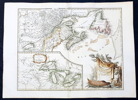
1768 De Vaugondy Large Antique Map Great Lakes of North America & Eastern Canada
- Title : Partie De L Amerique Septent. qui comprend La Nouvelle France ou le Canada...Par le Sr Robert de Vaugondy; Supplement pour Les Lacs du Canada
- Date : 1768
- Condition: (A+) Fine Condition
- Ref: 93128
- Size: 30in x 22in (760mm x 560mm)
Description:
This large original beautifully hand coloured, scarce 2nd edition antique map of The Great Lakes of North America, Eastern Canada & part of New England, with border changes from the 1763 Treaty of Paris, was published in 1768 by Robert Du Vaugondy in his Atlas Universal.
A nice example, beautiful hand colour on age toned heavy paper with original margins with a heavy dark ink denoting an early pressing.
General Definitions:
Paper thickness and quality: - Heavy and stable
Paper color : - off white
Age of map color: - Original & later
Colors used: - Yellow, green, blue, pink
General color appearance: - Authentic
Paper size: - 30in x 22in (760mm x 560mm)
Plate size: - 25in x 19 1/2in (635mm x 495mm)
Margins: - Min 1in (25mm)
Imperfections:
Margins: - Light spotting in top margin
Plate area: - None
Verso: - None
Background:
The mapping of the Great Lakes region began in the early seventeenth century, when the first indications of the lakes appeared on maps made by European cartographers. By the mid-1600s, the maps of French Royal Geographer Nicolas Sanson had recognizable depictions of all five Great Lakes. His map is imprecise—Lake Superior lacks its distinctive shape and is unbounded on the west—but Lakes Ontario, Erie, Huron and Michigan can be discerned without difficulty. The lack of any reference to the Mississippi River in Sansons map reflects how little cartographers really knew about the region at the time.
Until the late eighteenth century, maps were made with information acquired in an irregular and imprecise manner. They were not based on formal surveys, but on written records supplemented with sketches by explorers, missionaries and trappers traveling the Upper Midwest. European cartographers had the task of fitting together this often contradictory information and putting the results into the framework of a geographic map. Instead of being mapped in terms of latitude and longitude, prominent places were usually located in relation to other places, which were, of course, similarly positioned. Distances could not be measured with any accuracy at this time, so these maps were liable to gross errors.
The early maps in the Making Maps, Mapping History exhibit provide a capsulized view of the growth of geographical knowledge of the Great Lakes region. As noted above, Sansons map was the first to display all five of the Great Lakes. Vincenzo Maria Coronelli, the cosmographer of the Republic of Venice, used information supplied by Jesuit missionaries in a 1688 map that was the first accurate depiction of the Great Lakes and the Mississippi River. French cartographer Guillaume De LIsle further refined the image and provided an outline that was not substantially improved until surveyors entered the region in the nineteenth century.
The first official government surveys of the Great Lakes were hydrographic surveys conducted by the British Admiralty under the direction of Capt. Henry W. Bayfield. Bayfield spent his entire career surveying the St. Lawrence River and the Great Lakes, beginning with Lake Superior in 1816. The lake-shore city of Bayfield, Wis., was named in honor of this pioneer surveyor.
One of the first acts of the new government of the United States was to establish a system for the orderly settlement of its western lands. Under the Ordinance of 1785, land surveyors went into the western territories in advance of settlement to divide the land into townships of 36 square- mile sections. Though mapping was not the governments primary aim, the surveys provided ample grist for the mapmakers mill, and the regions were, for the first time, mapped with considerable accuracy. The federal government, however, was not yet in the business of making maps for the public. That was left to enterprising individuals, such as Samuel Morrison, Elisha Dwelle and Joshua Hathaway, who produced one of the first topographical maps of the Wisconsin Territory in 1837.
The surveys of the General Land Office served as the basis for the mapping of much of the Great Lakes region from around 1800, when the surveys began, until about 1890, when the U.S. Geological Survey began to map the region again. In some cases, however, the old surveys were not entirely superseded until the mid-20th century. The distinctive feature of maps based on these surveys is the invariable presence of the township grid.
As population and commerce in the Great Lakes region grew, the federal government assumed responsibility for charting the lakes for navigation. The U.S. Lake Survey began in 1841 with an appropriation of $15,000. Before the Civil War, the work was conducted by officers of the Corps of Topographical Engineers. Its initial survey was completed in 1882, but the need for contin- uous revisions caused it to be reactivated a few years later. The Topographical Engineers merged with the U.S. Army Corps of Engineers in 1863, and the Lake Survey remained in the hands of the Corps of Engineers until 1970, when it became part of the newly formed National Ocean Survey (now known as the National Ocean Service).
The U.S. Lake Survey conducted far more rigorous surveys than those of the General Land Office, which used instruments no more sophisticated than a surveyors compass and a Gunters chain. The Lake Survey used an array of precision instruments and employed triangulation to form the geographic framework of the maps. Triangulation allowed the transfer of geographical coordinates from point to point throughout the system and, for the first time, geographical locations were determined with precision. Inland navigation prompted Congress to order a variety of government surveys. During the era of canal building, surveys like the one for the Portage Canal were common. Most of them were conducted by the Corps of Engineers, as were the surveys of the great rivers, such as the Mississippi.
The degree of accuracy accorded Great Lakes navigators was generally not matched on land for many years to come. The task of precisely mapping the United States by covering it with large-scale topographic quadrangle maps was given to the newly formed U.S. Geological Survey (USGS) in the 1880s. John Wesley Powell, the second director of the USGS, stated that the mapping of the United States could be accomplished in 25 years, but that goal was not accomplished until the 1980s. The first topographic maps of Wisconsin appeared in the 1890s, when much of the southeastern part of the state was surveyed. The surveys were quickly done, however, and most of the sheets needed at least minor revision within the next decade. Despite a rapid start, the topographic mapping of Wisconsin bogged down and ultimately was not completed until 1983. Mapping standards changed entirely with the application of aerial photography around 1930. Following World War II, all Wisconsin topographic sheets were derived from photographs.
Today, polar-orbiting satellites with thematic mappers can, in a single day, record images that reveal Great Lakes water quality and temperature, the streets and large buildings of urban areas, and the general health of forests, wetlands and farmlands, including the identity of such crops as corn, hay and alfalfa. The detailed precision of todays computerized Space Age technology no doubt would have astounded Nicolas Sanson—but the seventeenth-century mapmakers ability to create a fairly accurate map of a world he had only heard and read about is equally astounding to twenty-first-century mapmakers.
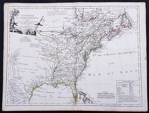
1783 R. De Vaugondy Large Antique 1st Post Revolutionary Map of North America
- Title : Amerique Septentrionale ...Les Etats Unis...1783...Robert De Vaugondy
- Ref #: 93503-1
- Size: 27 1/2in x 21 1/2in (700mm x 540mm)
- Date : 1783
- Condition: (A+) Fine Condition
Description:
This large original beautifully hand coloured copper plate antique map of post revolutionary North America & the newly form United States was engraved in 1783 - dated - and was published by Robert De Vaugondy in his large elephant folio Atlas Universal
This map is in beautiful original condition, original margins, original outline colour on strong sturdy paper with a heavy impression. A must for any collector of maps of historical importance.
General Definitions:
Paper thickness and quality: - Heavy and stable
Paper color : - off white
Age of map color: - Original
Colors used: - Blue, pink, red, green, yellow
General color appearance: - Authentic
Paper size: - 27 1/2in x 21 1/2in (700mm x 540mm)
Plate size: - 25 1/2in x 18 1/2in (650mm x 465mm)
Margins: - Min 1in (25mm)
Imperfections:
Margins: - None
Plate area: - None
Verso: - None
Background:
This is Robert De Vaugondys 5th State of his North America map and one of the first to show the newly liberated American States, after the American Revolutionary War 1775 - 1783.
The maps includes an engraved borderline for the newly founded United States as agreed upon by the Treaty of Paris in 1783. Also, the maps title was altered from earlier states to incorporate the name (in French) for the United States, Etats Unis, which also appears on the map itself. This state includes much other new information along with the place names that were added to the previous state, such as the Newport, New York City, and Bermuda. Florida is shown as an archipelago and the coastline of California is quite curious, with a continuation of the coastline in the inset map of the Northwest showing some of the mythical cartography, such as the Sea of the West and River of the West, which were debated among map scholars and explorers until Captain James Cook dispelled these myths in his three Voyages to the Pacific.
The map also locates the area identified as Fou-sang, reflecting the belief that Chinese mariners may have reached America, the location of the mythical colony of Fou-sang. According to some historians such as Charles Godfrey Leland and Joseph de Guignes ( Le Fou-Sang des Chinois est-il lAmérique Mémoires de lAcadémie des Inscriptions et Belles Lettres, tome 28, Paris, 1761), the distances given by Hui Shen (20,000 Chinese li) would locate Fou-sang on the west coast of the American continent, near British Columbia.
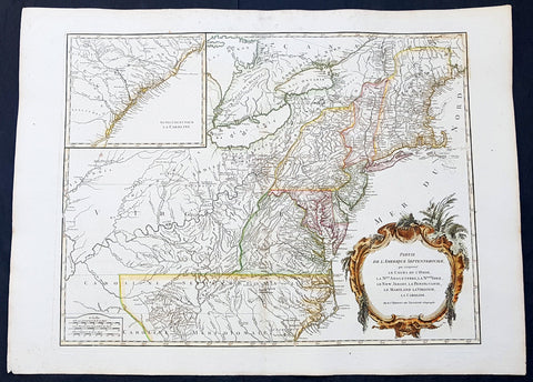
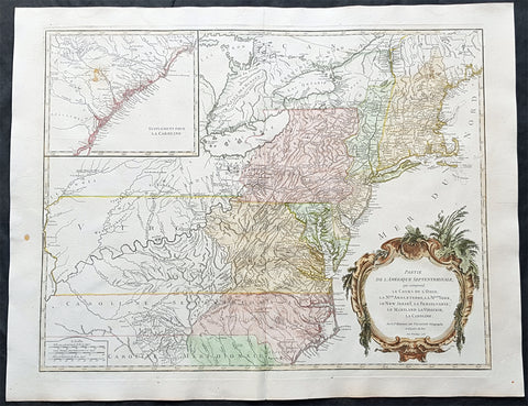
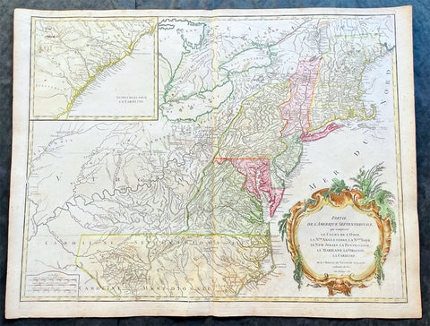
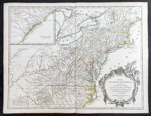
1768 Robert De Vaugondy Large Antique 2nd edition Map of Colonial United States
- Title : Partie De L Amerique Septentrionale, qui Comprend Le Cours De L Ohio...Par le Sr Robert de Vaugondy
- Date : 1768
- Condition: (A+) Fine Condition
- Ref: 93129
- Size: 30in x 22in (760mm x 560mm)
Description:
This large original beautifully hand coloured, scarce 2nd edition antique map of the east coast of the United States, illustrating the course of the Ohio River and stretching from New England to the Carolinas, north to the Great Lakes and south to the Mississippi - with an inset map of The Carolinas - was published in 1768 by Robert Du Vaugondy in his Atlas Universal.
This is one of the best examples of this map I have seen, beautiful hand colour on age toned heavy paper with original margins with a heavy dark ink denoting an early pressing.
General Definitions:
Paper thickness and quality: - Heavy and stable
Paper color : - off white
Age of map color: - Original & later
Colors used: - Yellow, green, blue, pink
General color appearance: - Authentic
Paper size: - 30in x 22in (760mm x 560mm)
Plate size: - 25in x 19 1/2in (635mm x 495mm)
Margins: - Min 1in (25mm)
Imperfections:
Margins: - Light spotting in top margin
Plate area: - None
Verso: - None
Background:
Second state of the early de Vaugondy map of the British colonies, with changes after the 1763 Treaty of Paris, with Virginia & Carolina extended to the Mississippi and Pennsylvania extended to Lake Erie. The majority of geographical information is based upon John Mitchells great map of North America from the mid 1750s, also drawing from Lewis, Evans on the Middle British Colonies and Joshua Frys and Peter Jeffersons map of Virginia and Maryland. The Mitchell map was the culmination of many years of British surveying in the North American Colonies and was considered one of the best maps of the continent available to Europeans and Americans in the mid-eighteenth century.
De Vaugondys rendition does not copy the full scope of Mitchells map but instead focuses on the colonies stretching from southern Maine to the Carolinas. In the top left corner is an inset of South Carolina and Georgia. De Vaugondy also pays special attention to the river systems and settlements. This map shows some of the earliest accurate information of the trans-Allegheny regions (the Ohio River, Kentucky, Tennessee and Parts of Ohio) and inland areas to the southeast of the Great Lakes and interior of New England.
Maine is still part of the Massachusetts Bay Colony. During this era. The dispute between New Hampshire and New York over who controlled the area which is now Vermont has been resolved. The outbreak of the French & Indian War (Seven Years War) briefly suspended interest in the disputed area, and it was not until 1764 that the British crown upheld New Yorks claim to Vermont. Included is a beautiful title cartouche in the Rococo style. (Ref: Tooley; M&B)
1768 Robert De Vaugondy Large Antique 2nd edition Map of Colonial United States
- Title : Partie De L Amerique Septentrionale, qui Comprend Le Cours De L Ohio...Par le Sr Robert de Vaugondy
- Date : 1768
- Condition: (A+) Fine Condition
- Ref: 93504
- Size: 30in x 21in (760mm x 550mm)
Description:
This large original beautifully hand coloured, scarce 2nd edition antique map of the east coast of the United States, illustrating the course of the Ohio River and stretching from New England to the Carolinas, north to the Great Lakes and south to the Mississippi - with an inset map of The Carolinas - was published in 1768 by Robert Du Vaugondy in his Atlas Universal.
This is one of the best examples of this map I have seen, beautiful hand colour on age toned heavy paper with original margins with a heavy dark ink denoting an early pressing.
General Definitions:
Paper thickness and quality: - Heavy and stable
Paper color : - off white
Age of map color: - Original & later
Colors used: - Yellow, green, blue, pink
General color appearance: - Authentic
Paper size: - 30in x 22in (760mm x 560mm)
Plate size: - 25in x 19 1/2in (635mm x 495mm)
Margins: - Min 1in (25mm)
Imperfections:
Margins: - None
Plate area: - None
Verso: - None
Background:
Second state of the early de Vaugondy map of the British colonies, with changes after the 1763 Treaty of Paris, with Virginia & Carolina extended to the Mississippi and Pennsylvania extended to Lake Erie. The majority of geographical information is based upon John Mitchells great map of North America from the mid 1750s, also drawing from Lewis, Evans on the Middle British Colonies and Joshua Frys and Peter Jeffersons map of Virginia and Maryland. The Mitchell map was the culmination of many years of British surveying in the North American Colonies and was considered one of the best maps of the continent available to Europeans and Americans in the mid-eighteenth century.
De Vaugondys rendition does not copy the full scope of Mitchells map but instead focuses on the colonies stretching from southern Maine to the Carolinas. In the top left corner is an inset of South Carolina and Georgia. De Vaugondy also pays special attention to the river systems and settlements. This map shows some of the earliest accurate information of the trans-Allegheny regions (the Ohio River, Kentucky, Tennessee and Parts of Ohio) and inland areas to the southeast of the Great Lakes and interior of New England.
Maine is still part of the Massachusetts Bay Colony. During this era. The dispute between New Hampshire and New York over who controlled the area which is now Vermont has been resolved. The outbreak of the French & Indian War (Seven Years War) briefly suspended interest in the disputed area, and it was not until 1764 that the British crown upheld New Yorks claim to Vermont. Included is a beautiful title cartouche in the Rococo style. (Ref: Tooley; M&B)
1768 Robert De Vaugondy Large Antique 2nd edition Map of Colonial United States
- Title : Partie De L Amerique Septentrionale, qui Comprend Le Cours De L Ohio...Par le Sr Robert de Vaugondy
- Date : 1755 (1768)
- Condition: (A) Very Good Condition
- Ref: 17057
- Size: 26in x 20 1/2in (660mm x 520mm)
Description:
This large original beautifully hand coloured, scarce 2nd edition antique map of the east coast of the United States, illustrating the course of the Ohio River and stretching from New England to the Carolinas, north to the Great Lakes and south to the Mississippi - with an inset map of The Carolinas - was published in 1768 - dated 1755 in the cartouche - by Robert Du Vaugondy in his Atlas Universal.
This map is all original with hand colour on age toned heavy paper with original margins with a heavy dark ink denoting an early pressing.
General Definitions:
Paper thickness and quality: - Heavy and stable
Paper color : - off white
Age of map color: - Original & later
Colors used: - Yellow, green, blue, pink
General color appearance: - Authentic
Paper size: - 26in x 20 1/2in (660mm x 520mm)
Plate size: - 25in x 19 1/2in (635mm x 495mm)
Margins: - Min 1/2in (12mm)
Imperfections:
Margins: - Age toning and spotting
Plate area: - Age toning and spotting
Verso: - Age toning and spotting
Background:
Second state of the early de Vaugondy map of the British colonies, with changes after the 1763 Treaty of Paris, with Virginia & Carolina extended to the Mississippi and Pennsylvania extended to Lake Erie. The majority of geographical information is based upon John Mitchells great map of North America from the mid 1750s, also drawing from Lewis, Evans on the Middle British Colonies and Joshua Frys and Peter Jeffersons map of Virginia and Maryland. The Mitchell map was the culmination of many years of British surveying in the North American Colonies and was considered one of the best maps of the continent available to Europeans and Americans in the mid-eighteenth century.
De Vaugondys rendition does not copy the full scope of Mitchells map but instead focuses on the colonies stretching from southern Maine to the Carolinas. In the top left corner is an inset of South Carolina and Georgia. De Vaugondy also pays special attention to the river systems and settlements. This map shows some of the earliest accurate information of the trans-Allegheny regions (the Ohio River, Kentucky, Tennessee and Parts of Ohio) and inland areas to the southeast of the Great Lakes and interior of New England.
Maine is still part of the Massachusetts Bay Colony. During this era. The dispute between New Hampshire and New York over who controlled the area which is now Vermont has been resolved. The outbreak of the French & Indian War (Seven Years War) briefly suspended interest in the disputed area, and it was not until 1764 that the British crown upheld New Yorks claim to Vermont. Included is a beautiful title cartouche in the Rococo style. (Ref: Tooley; M&B)
1755 (1768) Robert De Vaugondy Large Antique 2nd edition Map of Colonial United States
- Title : Partie De L Amerique Septentrionale, qui Comprend Le Cours De L Ohio...Par le Sr Robert de Vaugondy
- Date : 1755 (1768)
- Condition: (A+) Fine Condition
- Ref: 93514
- Size: 26in x 20 1/2in (660mm x 520mm)
Description:
This large original beautifully hand coloured, scarce 2nd edition antique map of the east coast of the United States, illustrating the course of the Ohio River and stretching from New England to the Carolinas, north to the Great Lakes and south to the Mississippi - with an inset map of The Carolinas - was published in 1768 - dated 1755 in the cartouche - by Robert Du Vaugondy in his Atlas Universal.
This map is all original with hand colour on age toned heavy paper with original margins with a heavy dark ink denoting an early pressing.
General Definitions:
Paper thickness and quality: - Heavy and stable
Paper color : - off white
Age of map color: - Original & later
Colors used: - Yellow, green, blue, pink
General color appearance: - Authentic
Paper size: - 26in x 20 1/2in (660mm x 520mm)
Plate size: - 25in x 19 1/2in (635mm x 495mm)
Margins: - Min 1/2in (12mm)
Imperfections:
Margins: - Light age toning in margins
Plate area: - None
Verso: - None
Background:
Second state of the early de Vaugondy map of the British colonies, with changes after the 1763 Treaty of Paris, with Virginia & Carolina extended to the Mississippi and Pennsylvania extended to Lake Erie. The majority of geographical information is based upon John Mitchells great map of North America from the mid 1750s, also drawing from Lewis, Evans on the Middle British Colonies and Joshua Frys and Peter Jeffersons map of Virginia and Maryland. The Mitchell map was the culmination of many years of British surveying in the North American Colonies and was considered one of the best maps of the continent available to Europeans and Americans in the mid-eighteenth century.
De Vaugondys rendition does not copy the full scope of Mitchells map but instead focuses on the colonies stretching from southern Maine to the Carolinas. In the top left corner is an inset of South Carolina and Georgia. De Vaugondy also pays special attention to the river systems and settlements. This map shows some of the earliest accurate information of the trans-Allegheny regions (the Ohio River, Kentucky, Tennessee and Parts of Ohio) and inland areas to the southeast of the Great Lakes and interior of New England.
Maine is still part of the Massachusetts Bay Colony. During this era. The dispute between New Hampshire and New York over who controlled the area which is now Vermont has been resolved. The outbreak of the French & Indian War (Seven Years War) briefly suspended interest in the disputed area, and it was not until 1764 that the British crown upheld New Yorks claim to Vermont. Included is a beautiful title cartouche in the Rococo style. (Ref: Tooley; M&B)
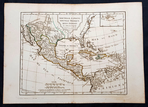
1795 Didier De Vaugondy Antique Map of Texas, Mexico, California, United States
- Title : Nouvelle Espagne Nouveau Mexique Isles Antilles Par Robert De Vaugondy ..L A 3 e
- Ref #: 93503
- Size: 16 1/2in x 11 1/2in (405mm x 295mm)
- Date : 1795
- Condition: (A+) Fine Condition
Description:
This original copper plate engraved map of North and Central America, with the Caribbean, by Didier De Vaugondy was published in the 1795 (L an 3e Post Revolution Year) edition of Nouvel Atlas Portatif
General Definitions:
Paper thickness and quality: - Heavy and stable
Paper color : - off white
Age of map color: - Original
Colors used: - Yellow, green, blue, pink
General color appearance: - Authentic
Paper size: - 16 1/2in x 11 1/2in (405mm x 295mm)
Plate size: - 12 1/2in x 10in (320mm x 255mm)
Margins: - Min 1in (25mm)
Imperfections:
Margins: - Light soiling
Plate area: - None
Verso: - None
Background:
The French Republican calendar also commonly called the French Revolutionary calendar (calendrier révolutionnaire français), was a calendar created and implemented during the French Revolution, and used by the French government for about 12 years from late 1793 to 1805, and for 18 days by the Paris Commune in 1871.
De Vaugondy, Didier Robert 1723 - 1786
Didier Robert de Vaugondy was the son of prominent geographer Gilles Robert de Vaugondy and Didier carried on his fathers impressive work. Together, they published their best-known work, the Atlas Universel (1757). The atlas took fifteen years to create and was released in a folio and ¾ folio edition; both are rare and highly sought-after today. Together and individually, father and son were known for their exactitude and depth of research.
Like his father, Didier served as geographer to King Louis XV. He was especially recognized for his skills in globe making; for example, a pair of his globes made for the Marquise de Pompadour are today in the collection of the Municipal Museum of Chartres. Didier was also the geographer to the Duke of Lorraine. In 1773, he was appointed royal censor in charge of monitoring the information published in geography texts, navigational tracts, and travel accounts.
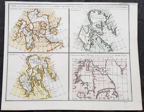
1773 Robert De Vaugondy & Denis Diderot Antique Maps x 4 of Hudson Bay, Canada
- Title : Carte qui represente les differentes connoissances que l on a eues des Terres Arctiques...Robert De Vaugondy...1773
- Size: 16 1/2in x 13in (420mm x 330mm)
- Condition: (A+) Fine Condition
- Date : 1773
- Ref #: 60048
Description:
This magnificent original hand coloured copper-plate engraved antique maps of 4 different time based views of Hudsons Bay & Eastern Canada by Robert De Vaugondy was engraved in 1773 - the date is engraved in the title - and published in the 1775 edition of Denis Diderots (1713-84) Encyclopédie, ou dictionnaire raisonné des sciences, des arts et des métiers (Encyclopedia, or a Systematic Dictionary of the Sciences, Arts, and Crafts).
The four historical views of Hudsons Bay, Canada are 2 x maps by Claude Delisle in 1700 & 1703, one map by Nicolas Sanson in 1750 and the fourth map by Henry Ellis in 1747.
Denis Diderot 1713 – 1784 was a French philosopher, art critic, and writer, best known for serving as co-founder, chief editor, and contributor to the Encyclopédie along with Jean le Rond d Alembert. He was a prominent figure during the Enlightenment.
Diderot began his education by obtaining a Master of Arts degree in philosophy at a Jesuit college in 1732. He considered working in the church clergy before briefly studying law. When he decided to become a writer in 1734, his father disowned him for not entering one of the learned professions. He lived a bohemian existence for the next decade. He befriended philosopher Jean-Jacques Rousseau in 1742.
Though his work was broad as well as rigorous, it did not bring Diderot riches. He secured none of the posts that were occasionally given to needy men of letters; he could not even obtain the bare official recognition of merit that was implied by being chosen a member of the Académie française. He saw no alternative to selling his library to provide a dowry for his daughter. Empress Catherine II of Russia heard of his financial troubles and commissioned an agent in Paris to buy the library. She then requested that the philosopher retain the books in Paris until she required them, and act as her librarian with a yearly salary. Between October 1773 and March 1774, the sick Diderot spent a few months at the empress\'s court in Saint Petersburg.
Diderot died of pulmonary thrombosis in Paris on 31 July 1784, and was buried in the city\'s Église Saint-Roch. His heirs sent his vast library to Catherine II, who had it deposited at the National Library of Russia. He has several times been denied burial in the Panthéon with other French notables. The French government considered memorializing him in this fashion on the 300th anniversary of his birth, but this did not come to pass.
Diderot\'s literary reputation during his lifetime rested primarily on his plays and his contributions to the Encyclopédie; many of his most important works, including Jacques the Fatalist, Rameaus Nephew, Paradox of the Actor, and D Alembert\'s Dream, were published only after his death.
General Definitions:
Paper thickness and quality: - Heavy and stable
Paper color : - off white
Age of map color: - Original
Colors used: - Yellow, green, blue, pink
General color appearance: - Authentic
Paper size: - 16 1/2in x 13in (420mm x 330mm)
Plate size: - 16in x 12 1/2in (405mm x 315mm)
Margins: - Min 1/2in (10mm)
Imperfections:
Margins: - None
Plate area: - None
Verso: - None
Background:
Hudson Bay (sometimes called Hudsons Bay, usually historically) is a large body of saltwater in northeastern Canada.
The Eastern Cree name for Hudson and James Bay is Wînipekw (Southern dialect) or Wînipâkw (Northern dialect), meaning muddy or brackish water. Lake Winnipeg is similarly named by the local Cree, as is the location for the city of Winnipeg.
English explorers and colonists named Hudson Bay after Sir Henry Hudson who explored the bay beginning August 2, 1610 on his ship Discovery. 170 On his fourth voyage to North America, Hudson worked his way around Greenlands west coast and into the bay, mapping much of its eastern coast. Discovery became trapped in the ice over the winter, and the crew survived onshore at the southern tip of James Bay. When the ice cleared in the spring, Hudson wanted to explore the rest of the area, but the crew mutinied on June 22, 1611. They left Hudson and others adrift in a small boat. No one knows the fate of Hudson or the crew members stranded with him, but historians see no evidence that they survived for long afterwards.
In 1668, Nonsuch reached the bay and traded for beaver pelts, leading to the creation of the Hudson\'s Bay Company (HBC) which still bears the historic name. The HBC negotiated a trading monopoly from the English crown for the Hudson Bay watershed, called Rupert\'s Land. France contested this grant by sending several military expeditions to the region, but abandoned its claim in the Treaty of Utrecht (April 1713).
During this period, the Hudsons Bay Company built several factories (forts and trading posts) along the coast at the mouth of the major rivers (such as Fort Severn, Ontario; York Factory and Churchill, Manitoba). The strategic locations were bases for inland exploration. More importantly, they were trading posts with the indigenous peoples who came to them with furs from their trapping season. The HBC shipped the furs to Europe and continued to use some of these posts well into the 20th century. (Ref: Tooley; M&B)

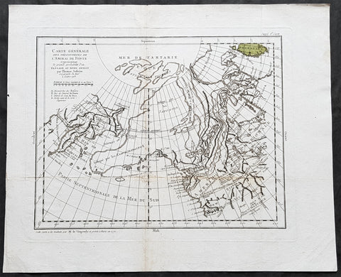
1772 De Vaugondy Visscher Large Antique Map of California & SW America
- Title : Carte De La Californie Et Des Pays Nord Ouest separes de L'Asie par le Detroit d'Anian…1772
- Date : 1772
- Ref # : 50674
- Size : 20in x 15 3/4in (510mm x 400mm)
Description:
Fascinating study in the comparative cartography of the West Coast of North America, from the Straits of Anian to Cabo San Lucas and the southern tip of Baja California. The work consists of extracts from two maps, both reportedly done by Visscher in the 1612 and 1641 respectively and with information derived from Mercator and Plancius. The larger map prominently shows the Strait of Anian, Anian Regnum, Quivira Regnum, the Sierra Nevada, Nova Albion, Tontonteac Regnum, Tolm Regnum and a coastal detail which includes over 30 coastal place names, including Mendocino, San Miguel (San Diego), Cape Fortuna, I. De Paxaros (Catalina?), and many mythical/ephemeral place names. The smaller map also shows the Straits of Anian, but depicts an open sea above, clearly portending a NW Passage in the Arctic Circle. The NW Coastline differs radically, and only Anian Regnum and Quivira Regnum are located, that later considerably south of the location on the larger map. The smaller map includes a similar number of coastal placenames, but includes several important ones not listed on the larger map, including C. Blanco (3 times), C. de San Francisco and los Farilones, but ommits any significant effort to depict bays.
General Description:
Paper thickness and quality: - Heavy and stable
Paper color: - off white
Age of map color: - Later
Colors used: - Yellow
General color appearance: - Authentic
Paper size: - 20in x 15 3/4in (510mm x 400mm)
Plate size: - 16in x 12 1/2in (410mm x 320mm)
Margins: - Min 2in (50mm)
Imperfections:
Margins: - None
Plate area: - None
Verso: - None
Encyclopaedie Raisonee des Sciences des Artes:
At the time of publication these maps of Encyclopedie were some of the most in-depth and accurate maps published of Asia, Canada, California and the NW region of America.
Diderot's maps were intended to further an understanding of the Western Coast of America, and NE Asia, during a time period immediately prior to Cook's voyage to the region - less than a decade later- where numerous theories abounded on the NW Coast of America. A nice dark impression of this essential map for American map collectors. (Ref: Tooley; M&B)
1772 Robert De Vaugondy & Diderot Antique Map of America - California to Alaska
- Title : Carte Generale Des Decouvertes De L Amiral De Fonte representant la grande probabilite d\'un Passage au Nord Ouestg par Thomas Jefferys . . . 1768
- Size: 19in x 15 3/4in (480mm x 400mm)
- Condition: (A) Very Good Condition
- Date : 1772
- Ref #: 30844
Description:
This magnificent original copper-plate engraved antique map of the NW coast of America based upon the Thomas Jefferys map of 1768, by Robert De Vaugondy in 1772, by Robert De Vaugondy was engraved in 1772 - the date is engraved at the foot of the map - and published in the 1775 edition of Denis Diderots (1713-84) Encyclopédie, ou dictionnaire raisonné des sciences, des arts et des métiers (Encyclopedia, or a Systematic Dictionary of the Sciences, Arts, and Crafts).
Denis Diderot 1713 – 1784 was a French philosopher, art critic, and writer, best known for serving as co-founder, chief editor, and contributor to the Encyclopédie along with Jean le Rond d Alembert. He was a prominent figure during the Enlightenment.
Diderot began his education by obtaining a Master of Arts degree in philosophy at a Jesuit college in 1732. He considered working in the church clergy before briefly studying law. When he decided to become a writer in 1734, his father disowned him for not entering one of the learned professions. He lived a bohemian existence for the next decade. He befriended philosopher Jean-Jacques Rousseau in 1742.
Though his work was broad as well as rigorous, it did not bring Diderot riches. He secured none of the posts that were occasionally given to needy men of letters; he could not even obtain the bare official recognition of merit that was implied by being chosen a member of the Académie française. He saw no alternative to selling his library to provide a dowry for his daughter. Empress Catherine II of Russia heard of his financial troubles and commissioned an agent in Paris to buy the library. She then requested that the philosopher retain the books in Paris until she required them, and act as her librarian with a yearly salary. Between October 1773 and March 1774, the sick Diderot spent a few months at the empress\'s court in Saint Petersburg.
Diderot died of pulmonary thrombosis in Paris on 31 July 1784, and was buried in the city\'s Église Saint-Roch. His heirs sent his vast library to Catherine II, who had it deposited at the National Library of Russia. He has several times been denied burial in the Panthéon with other French notables. The French government considered memorializing him in this fashion on the 300th anniversary of his birth, but this did not come to pass.
Diderot\'s literary reputation during his lifetime rested primarily on his plays and his contributions to the Encyclopédie; many of his most important works, including Jacques the Fatalist, Rameaus Nephew, Paradox of the Actor, and D Alembert\'s Dream, were published only after his death.
General Definitions:
Paper thickness and quality: - Heavy and stable
Paper color : - off white
Age of map color: - Original
Colors used: - Yellow, green, blue, pink
General color appearance: - Authentic
Paper size: - 16 1/2in x 13in (420mm x 330mm)
Plate size: - 16in x 12 1/2in (405mm x 315mm)
Margins: - Min 1/2in (10mm)
Imperfections:
Margins: - None
Plate area: - None
Verso: - None
Background:
Interesting map of the NW Coast of America and the NE Coast of Asia, based upon the Thomas Jefferys map of 1768.
Prior to Cooks 1st Voyage, the English, French and Russians were actively debating the cartography of the region in the North Pacific between Asia and North America. The Russian explorations of the first half of the 18th Century, including those by Behring, Tchirikow and others, had been reported by JN De L Isle, who had worked with the Russians and was privy to their latest discoveries. The mythical voyages of De Fuca, d Aguilar and De Font were still very much in evidence in contemporary cartography, as were concepts of a NW Passage, the Sea of the West, River of the West and other vestiges of 16th and 17th Century conjectural/mythical cartography.
Following the publication by Buache of his maps on the region, the debate between the French and English was quite fertile, so much so that Diderot dedicated most of his 10 map supplments to the region.
This map shows the Jefferys model, including a wide De Fuca based River from Puget Sound to the Atlantic over Hudson\'s Bay, several significant rivers flowing from the Pacific to the middle of North America, and Jesuit based water passages from the Pacific to the Arctic Seas. A marvelous approximation of Alaskan Archipelago is shown, along with the Russian discoveries. (Ref: Tooley; M&B)