Military (2)
1804 J Marshall Original Antique American Revolutionary War Map Battle of Quebec
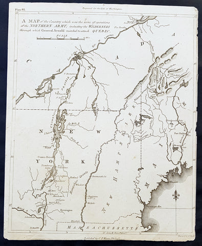
- Title : A Map of the Country which was the scene of operations of the Northern Army; including the Wilderness through which General Arnold marched to attack Quebec
- Size: 11in x 9in (280mm x 225mm)
- Ref #: 35091
- Date : 1804
- Condition: (A) Very Good Condition
Description:
This fine original copper-plate engraved antique map of the Battle of Quebec - covering New York, New Hampshire and Quebec Canada - in December 1775 during the American Revolutionary War, was published in the first 1804 edition of John Marshalls The Life of George Washington, Commander in Chief of the American Forces, during the War which established the Independence of his Country.............
General Definitions:
Paper thickness and quality: - Heavy and stable
Paper color : - off white
Age of map color: -
Colors used: -
General color appearance: -
Paper size: - 11in x 9in (280mm x 225mm)
Plate size: - 11in x 9in (280mm x 225mm)
Margins: - Min 1/8in (2mm)
Imperfections:
Margins: - Right margin cropped close to border
Plate area: - Light vertical crease as issued
Verso: - None
Background:
The Battle of Quebec was fought on December 31, 1775, between American Continental Army forces and the British defenders of Quebec City early in the American Revolutionary War. The battle was the first major defeat of the war for the Americans, and it came with heavy losses. General Richard Montgomery was killed, Benedict Arnold was wounded, and Daniel Morgan and more than 400 men were taken prisoner. The city\'s garrison, a motley assortment of regular troops and militia led by Quebec\'s provincial governor, General Guy Carleton, suffered a small number of casualties.
Montgomery\'s army had captured Montreal on November 13, and early in December they joined a force led by Arnold, whose men had made an arduous trek through the wilderness of northern New England. Governor Carleton had escaped from Montreal to Quebec, the Americans\' next objective, and last-minute reinforcements arrived to bolster the city\'s limited defenses before the attacking force\'s arrival. Concerned that expiring enlistments would reduce his force, Montgomery made the end-of-year attack in a blinding snowstorm to conceal his army\'s movements. The plan was for separate forces led by Montgomery and Arnold to converge in the lower city before scaling the walls protecting the upper city. Montgomery\'s force turned back after he was killed by cannon fire early in the battle, but Arnold\'s force penetrated further into the lower city. Arnold was injured early in the attack, and Morgan led the assault in his place before he became trapped in the lower city and was forced to surrender. Arnold and the Americans maintained an ineffectual blockade of the city until spring, when British reinforcements arrived.
In the battle and the following siege, French-speaking Canadians were active on both sides of the conflict. The American forces received supplies and logistical support from local residents, and the citys defenders included locally raised militia. When the Americans retreated, they were accompanied by a number of their supporters; those who remained behind were subjected to a variety of punishments after the British re-established control over the province.
1865 James Wyld Large Antique Folding American Civil War Map - Extremely Rare
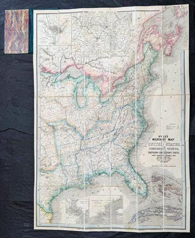
- Title : Wyld's Military Map Of The United States, The Northern States, And The Southern Confederate States: With The Forts, Harbours, Arsenals And Military Positions. James Wyld, 457 Strand; Charing Cross East And 2, Royal Exchange London. ......London, Published By James Wyld, Geographer To The Queen
- Date : 1865
- Size: 34 1/2in x 24in (875mm x 610mm)
- Condition: (A+) Fine Condition
- Ref: 35660
Description:
A very rare map of the United States first issued in 1861, during the Secession Crises that preceded the outbreak of the American Civil War, with this rare edition issued in January 1865 - dated at the foot of the map, only 4 months before the end of the war..
There are a few 1861 editions of this map for sale, currently on the market, but I have been unable to find an 1865 edition, either currently on the market or sold in the past.
General Definitions:
Paper thickness and quality: - Heavy and stable
Paper color : - off white
Age of map color: - Original
Colors used: - Yellow, green, blue, pink
General color appearance: - Authentic
Paper size: - 34 1/2in x 24in (875mm x 610mm)
Plate size: - 34 1/2in x 24in (875mm x 610mm)
Margins: - Min 1/2in (12mm)
Imperfections:
Margins: - None
Plate area: - None
Verso: - None
Background:
Wyld was particularly masterful at capturing political events throughout the world as they happened and leveraging his impressive publishing operation to quickly produce and distribute pertinent to the invested public. In this case, the map distinguishes between the 'Northern States' (orange border) and the 'Southern Confederate States' (blue border). Wyld here erroneously conflates slaveholding states with Confederate secessionist states - in particular, Missouri, Kentucky, Delaware, and Maryland, which allowed slavery but remained loyal to the Union. Arsenals, forts, and military posts highlighted and keyed, underscoring that 'war' was very much in the air. The map is also noteworthy for recognizes the apocryphal territory 'Chippewa', roughly corresponding to modern-day North Dakota.
This map is scarce to the market. Known institutions holdings at the Boston Public Library, the Library of Congress, Bibliothèque nationale de France, the David Rumsey Collection, among others. (Ref: M&B; Tooley; Clancy) (Ref: Tooley, Koeman, Burden)
Please note all items auctioned are genuine, we do not sell reproductions. A Certificate of Authenticity (COA) can be issued on request.