Military (7)
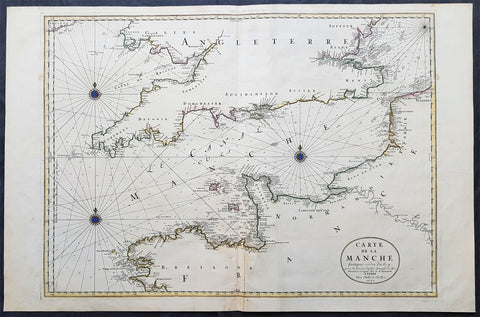
1692 Jaillot Large Antique Map Sea Chart The English Channel during 9 Years War
- Title : Carte De La Manche faite par ordre du Roy. pour le Service de les Armees de Mer.....a Paris...1692
- Size: 38in x 25in (960m x 635mm)
- Condition: (A+) Fine Condition
- Date : 1692
- Ref #: 16371
Description:
This very large, beautifully hand coloured original copper-plate engraved antique map, a large Sea Chart of The English Channel - produced for the French Navy during the Nine Years War and specifically the Battle of Beachy Head - was engraved in 1692, dated in the cartouche, and was published for Alexis Hubert Jaillots 1698 edition of his monumental Atlas Nouveau.
General Definitions:
Paper thickness and quality: - Heavy and stable
Paper color : - off white
Age of map color: - Original
Colors used: - Yellow, pink, green, blue
General color appearance: - Authentic
Paper size: - 38in x 25in (960m x 635mm)
Plate size: - 32 1/2in x 23 1/2in (825mm x 595mm)
Margins: - Min 1in (25mm)
Imperfections:
Margins: - None
Plate area: - None
Verso: - None
Background:
The Nine Years War (1688–97)—often called the War of the Grand Alliance or the War of the League of Augsburg—was a conflict between Louis XIV of France and a European coalition of the Holy Roman Empire, led by Austria, the Dutch Republic, Spain, England and Savoy. It was fought in Europe and the surrounding seas, North America and in India. It is sometimes considered the first global war. The conflict encompassed the Williamite war in Ireland and Jacobite risings in Scotland, where William III and James II struggled for control of England and Ireland, and a campaign in colonial North America between French and English settlers and their respective Indigenous allies, today called King Williams War by Americans.
Louis XIV of France had emerged from the Franco-Dutch War in 1678 as the most powerful monarch in Europe, an absolute ruler who had won numerous military victories. Using a combination of aggression, annexation, and quasi-legal means, Louis XIV set about extending his gains to stabilize and strengthen France\'s frontiers, culminating in the brief War of the Reunions (1683–84). The Truce of Ratisbon guaranteed France\'s new borders for twenty years, but Louis XIV\'s subsequent actions—notably his Edict of Fontainebleau (the revocation of the Edict of Nantes) in 1685— led to the deterioration of his military and political dominance. Louis XIVs decision to cross the Rhine in September 1688 was designed to extend his influence and pressure the Holy Roman Empire into accepting his territorial and dynastic claims. Leopold I and the German princes resolved to resist, and when the States General and William III brought the Dutch and the English into the war against France, the French King faced a powerful coalition aimed at curtailing his ambitions.
The main fighting took place around Frances borders in the Spanish Netherlands, the Rhineland, the Duchy of Savoy and Catalonia. The fighting generally favoured Louis XIV\'s armies, but by 1696 his country was in the grip of an economic crisis. The Maritime Powers (England and the Dutch Republic) were also financially exhausted, and when Savoy defected from the Alliance, all parties were keen to negotiate a settlement. By the terms of the Treaty of Ryswick (1697) Louis XIV retained the whole of Alsace but was forced to return Lorraine to its ruler and give up any gains on the right bank of the Rhine. Louis XIV also accepted William III as the rightful King of England, while the Dutch acquired a Barrier fortress system in the Spanish Netherlands to help secure their borders. With the ailing and childless Charles II of Spain approaching his end, a new conflict over the inheritance of the Spanish Empire embroiled Louis XIV and the Grand Alliance in the War of the Spanish Succession.
The Battle of Beachy Head (Bévéziers) was a naval engagement fought on 10 July 1690 during the Nine Years\' War. The battle was the greatest French tactical naval victory over their English and Dutch opponents during the war. The Dutch lost six ships of the line (sources vary) and three fireships; their English allies also lost one ship of the line, whereas the French did not lose a vessel. Control of the English Channel temporarily fell into French hands but Vice-Admiral Tourville failed to pursue the Allied fleet with sufficient vigour, allowing it to escape to the River Thames.
Tourville was criticised for not following up his victory and was relieved of his command. The English Admiral Arthur Herbert, 1st Earl of Torrington – who had advised against engaging the superior French fleet but had been overruled by Queen Mary and her ministers – was court-martialled for his performance during the battle. Although he was acquitted, King William dismissed him from the service.
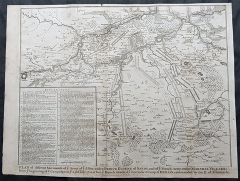
1745 Tindal Large Original Antique Map Battle Plan of Denain, France in 1712
- Title : Plan of the movements of ye Armies of ye Allies under Prince Eugene of Savoy and of ye French Army under Marshal Villars; from ye beginning of ye campaign to ye 24th July 1712, when ye French attacked ye intrenchement Camp at Denain commanded by the E. of Albemarle
- Size: 19 1/2in x 15 1/2in (495mm x 395mm)
- Condition: (A+) Fine Condition
- Date : 1745
- Ref #: 15655
Description:
This original copper-plate engraved antique map, battle plan of the Battle of Denain - during the Spanish War of Succession (1701-13) - centering on the cities of Douai & Bouchain in northern France, was published in the 1745 edition of Nicholas Tindals Continuation of Mr. Rapin\'s History of England.
General Definitions:
Paper thickness and quality: - Heavy and stable
Paper color : - off white
Age of map color: -
Colors used: -
General color appearance: -
Paper size: - 19 1/2in x 15 1/2in (495mm x 395mm)
Plate size: - 19 1/2in x 15 1/2in (495mm x 395mm)
Margins: - Min 1/2in (12mm)
Imperfections:
Margins: - Age toning
Plate area: - Age toning
Verso: - Age toning
Background:
The Battle of Denain was fought on 24 July 1712, as part of the War of the Spanish Succession. It resulted in a French victory under Marshal Villars against Dutch and Austrian forces under Prince Eugene of Savoy.
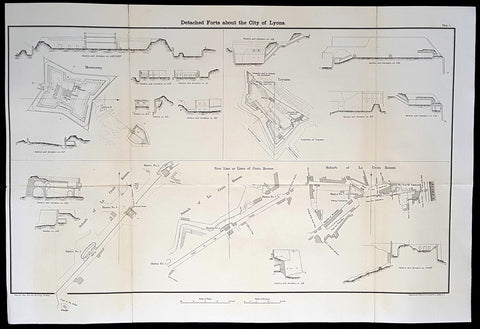
1856 Capt Delafield Large Antique Schematics Forts City of Lyons, France
- Title : Detached Forts about the City of Lyons
- Date : 1856
- Condition: (A) Very Good Condition
- Ref: 90193
- Size: 29in x 20in (735mm x 515mm)
This large original lithograph print, schematics of the forts or Belts of Lyon, France - during the time of the Crimean War and just prior to the American Civil War - was engraved by John T Bowen & co. of Philadelphia and was published in the 1856 edition of Captain Richard Delafields Report on the Art of War in Europe in 1854, 1855, and 1856.
In early 1855, Captain Richard Delafield was appointed by the Secretary of War, Jefferson Davis, a head of the board of officers, later called The Delafield Commission, and sent to Europe to study the European military. The board included Captain George B. McClellan and Major Alfred Mordecai. They inspected the state of the military in Great Britain, Germany, the Austrian Empire, France, Belgium, and Russia, and served as military observers during the Crimean War. After his return in April 1856, Delafield submitted a report which was later published as a book by Congress, Report on the Art of War in Europe in 1854, 1855, and 1856. The book was suppressed during the American Civil War due to fears that it would be instructive to Confederate engineers as it contained multiple drawings and descriptions of military fortifications.
General Definitions:
Paper thickness and quality: - Light and stable
Paper color : - off white
Age of map color: -
Colors used: -
General color appearance: -
Paper size: - 29in x 20in (735mm x 515mm)
Plate size: - 29in x 20in (735mm x 515mm)
Margins: - Min 1/2in (12mm)
Imperfections:
Margins: - None
Plate area: - Folds as issued
Verso: - Folds re-enforced with archival tape
Background:
The ceintures de Lyon (Belts of Lyon) were a series of fortifications built between 1830 and 1890 around the city of Lyon, France to protect the city from foreign invasion.
The belts comprised two defensive barriers that included forts, lunettes, ramparts, batteries, and other defensive structures. Many of these structures proved to be ineffective in war due to advancement in weapon technology and the evolution of attack strategies at the time. Some of the fortifications of the ceintures de Lyon have been destroyed, though many remain today.
In 1830 the maréchal de camp, Hubert Rohault de Fleury, commenced a project designed by military engineer Baron Haxo. With a budget of 10,000,000 francs (approximately €67,000,000 as of 2015) allocated for Lyon between 1831 and 1839, this first project included the restoration of the fortifications between Croix Rousse and Fourvière; the construction of two forts on the plateau of Caluire (Fort de Montessuy and Fort de Caluire, connected by the Enceinte de Caluire), facing the Dombes; closing access to the Presquîle by the construction of a south-facing building; building two forts – Fort de la Duchère and Fort de Grange Blanche – to protect access routes towards Paris and Auvergne.
The fortification of the city is divided into three sectors: The north was protected by the wall of Croix-Rousse and the structures between the Rhône and the Saône. The command was situated at fort de Montessuy. The west was covered by the hillfort of Fourvière and the associated forts of Vaise at Sainte-Foy. The command was situated at fort Saint-Irénée. The east was defended by the Redoute du Haut-Rhône and Fort de la Vitriolerie on the left bank of the Rhône. The command was situated at Fort Lamothe.
The work required almost 20,000 workers, which were locally sourced in an attempt to avoid insurrection such as the ongoing unrest of the Lyon silk workers (Canuts) over increased capitalism. Work began in 1831 to build seven structures, each structure requiring between 400 and 500 workers. The scope of this project included the construction of Fort de Montessuy and Fort de Caluire to the north; Fort des Brotteaux, Fort Montluc and Fort du Colombier to the east; the Redoute de la Part-Dieu to the west; and Fort Saint-Irénée, to protect the entire area.
In January 1831, an uprising began at a work site in Charpennes, however it was quickly stopped by the army. Other insurrections took place the same year, a series of Canut revolts, which succeeded in rallying soldiers on the side of the Canuts, resulting in the death of captain Viquesnel, aide-de-camp of Fleury, and the temporary withdrawal of the 20,000 soldiers who eventually retook the city in December 1831.
In 1832, three other structures were built to reinforce the defenses to the east: The Redoute de la Tête dor, Fort La Motte, and the Redoute des Hirondelles. A treaty was signed between the city of Lyon and the War Department, which stipulated that the city had to cede the land necessary for the construction of military buildings to the War Department, while the forts themselves would still belong to the city if the military decided to abandon them. It is thanks to this treaty that the forts of Croix Rousse, Fourvière, Loyasse, Vaise, and Saint-Jean would later be returned to the city.
Construction resumed in 1840. First the Fort de la Vitriolerie in 1840, then Fort de Sainte-Foy-lès-Lyon and the Lunette des Charpennes in 1842, Fort de la Duchère in 1844, the Redoute du Petit Sainte-Foy-lès-Lyon in 1852, and finally the Redoute du haut-Rhône in 1854.
A law was voted in on 10 July 1851, which defined the methods of destruction of these buildings or construction on their land. By 1854, 19 structures including 10 forts had been built around Lyon, creating a nearly 14-kilometre (8.7 mi) fortified perimeter.
Delafield, Richard Major General 1798 - 1873
Delafield was a United States Army officer for 52 years. He served as superintendent of the United States Military Academy for 12 years. At the start of the American Civil War, then Colonel Delafield helped equip and send volunteers from New York to the Union Army. He also was in command of defences around New York harbor from 1861 to April 1864. On April 22, 1864, he was promoted to Brigadier General in the Regular Army of the United States and Chief of Engineers. On March 8, 1866, President Andrew Johnson nominated Delafield for appointment to the grade of brevet major general in the Regular Army, to rank from March 13, 1865, and the United States Senate confirmed the appointment on May 4, 1866, reconfirmed due to a technicality on July 14, 1866. He retired from the US Army on August 8, 1866. He later served on two commissions relating to improvements to Boston Harbor and to lighthouses. He also served as a regent of the Smithsonian Institution.
Delafield served as assistant engineer in the construction of Hampton Roads defences from 1819–1824 and was in charge of fortifications and surveys in the Mississippi River delta area in 1824-1832. While superintendent of repair work on the Cumberland Road east of the Ohio River, he designed and built Dunlaps Creek Bridge in Brownsville, Pennsylvania, the first cast-iron tubular-arch bridge in the United States. Commissioned a major of engineers in July 1838, he was appointed superintendent of the Military Academy after the fire of 1838 and served till 1845. He designed the new buildings and the new cadet uniform that first displayed the castle insignia. He superintended the construction of coast defences for New York Harbor from 1846 to 1855.
In the beginning of 1855, Delafield was appointed by the Secretary of War, Jefferson Davis a head of the board of officers, later called The Delafield Commission, and sent to Europe to study the European military. The board included Captain George B. McClellan and Major Alfred Mordecai. They inspected the state of the military in Great Britain, Germany, the Austrian Empire, France, Belgium, and Russia, and served as military observers during the Crimean War. After his return in April 1856, Delafield submitted a report which was later published as a book by Congress, Report on the Art of War in Europe in 1854, 1855, and 1856. The book was suppressed during the American Civil War due to fears that it would be instructive to Confederate engineers as it contained multiple drawings and descriptions of military fortifications.
Delafield served as superintendent of the Military Academy again in 1856-1861. In January 1861, he was succeeded by Captain Pierre G. T. Beauregard, who was dismissed shortly after Beauregards home state of Louisiana seceded from the Union, and Delafield returned as superintendent serving until March 1, 1861. In the beginning of the Civil War he advised the governor of New York Edwin D. Morgan during the volunteer force creation. Then, in 1861–1864, he was put in charge of New York Harbor defences, including Governors Island and Fort at Sandy Hook. On May 19, 1864, he was commissioned a brigadier-general after replacing Joseph Gilbert Totten, who had died, as the Chief of Engineers, United States Army Corps of Engineers, on April 22, 1864. He stayed in charge of the Bureau of Engineers of the War Department until his retirement on August 8, 1866. On March 8, 1866, President Andrew Johnson nominated Delafield for appointment to the grade of brevet major general in the Regular Army of the United States, to rank from March 13, 1865, and the United States Senate confirmed the appointment on May 4, 1866 and reconfirmed it due to a technicality on July 14, 1866.After retirement Delafield served as a regent of the Smithsonian Institution and a member of the Lighthouse Board. He died in Washington, D.C. on November 5, 1873.
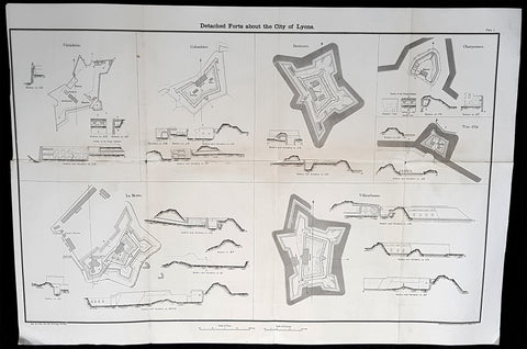
1856 Capt Delafield Large Antique Schematics Forts City of Lyons, France
- Title : Detached Forts about the City of Lyons
- Date : 1856
- Condition: (A) Very Good Condition
- Ref: 90123
- Size: 29in x 20in (735mm x 515mm)
Description:
This large original lithograph print, schematics of various forts in and around the French city of Lyons - during the time of the Crimean War and just prior to the American Civil War - was engraved by John T Bowen & co. of Philadelphia and was published in the 1856 edition of Captain Richard Delafields Report on the Art of War in Europe in 1854, 1855, and 1856.
In early 1855, Captain Richard Delafield was appointed by the Secretary of War, Jefferson Davis, a head of the board of officers, later called The Delafield Commission, and sent to Europe to study the European military. The board included Captain George B. McClellan and Major Alfred Mordecai. They inspected the state of the military in Great Britain, Germany, the Austrian Empire, France, Belgium, and Russia, and served as military observers during the Crimean War. After his return in April 1856, Delafield submitted a report which was later published as a book by Congress, Report on the Art of War in Europe in 1854, 1855, and 1856. The book was suppressed during the American Civil War due to fears that it would be instructive to Confederate engineers as it contained multiple drawings and descriptions of military fortifications.
General Definitions:
Paper thickness and quality: - Light and stable
Paper color : - off white
Age of map color: -
Colors used: -
General color appearance: -
Paper size: - 29in x 20in (735mm x 515mm)
Plate size: - 29in x 20in (735mm x 515mm)
Margins: - Min 1/2in (12mm)
Imperfections:
Margins: - None
Plate area: - Folds as issued
Verso: - Folds re-enforced with archival tape
Background:
The ceintures de Lyon (Belts of Lyon) were a series of fortifications built between 1830 and 1890 around the city of Lyon, France to protect the city from foreign invasion.
The belts comprised two defensive barriers that included forts, lunettes, ramparts, batteries, and other defensive structures. Many of these structures proved to be ineffective in war due to advancement in weapon technology and the evolution of attack strategies at the time. Some of the fortifications of the ceintures de Lyon have been destroyed, though many remain today.
In 1830 the maréchal de camp, Hubert Rohault de Fleury, commenced a project designed by military engineer Baron Haxo. With a budget of 10,000,000 francs (approximately €67,000,000 as of 2015) allocated for Lyon between 1831 and 1839, this first project included the restoration of the fortifications between Croix Rousse and Fourvière; the construction of two forts on the plateau of Caluire (Fort de Montessuy and Fort de Caluire, connected by the Enceinte de Caluire), facing the Dombes; closing access to the Presquîle by the construction of a south-facing building; building two forts – Fort de la Duchère and Fort de Grange Blanche – to protect access routes towards Paris and Auvergne.
The fortification of the city is divided into three sectors: The north was protected by the wall of Croix-Rousse and the structures between the Rhône and the Saône. The command was situated at fort de Montessuy. The west was covered by the hillfort of Fourvière and the associated forts of Vaise at Sainte-Foy. The command was situated at fort Saint-Irénée. The east was defended by the Redoute du Haut-Rhône and Fort de la Vitriolerie on the left bank of the Rhône. The command was situated at Fort Lamothe.
The work required almost 20,000 workers, which were locally sourced in an attempt to avoid insurrection such as the ongoing unrest of the Lyon silk workers (Canuts) over increased capitalism. Work began in 1831 to build seven structures, each structure requiring between 400 and 500 workers. The scope of this project included the construction of Fort de Montessuy and Fort de Caluire to the north; Fort des Brotteaux, Fort Montluc and Fort du Colombier to the east; the Redoute de la Part-Dieu to the west; and Fort Saint-Irénée, to protect the entire area.
In January 1831, an uprising began at a work site in Charpennes, however it was quickly stopped by the army. Other insurrections took place the same year, a series of Canut revolts, which succeeded in rallying soldiers on the side of the Canuts, resulting in the death of captain Viquesnel, aide-de-camp of Fleury, and the temporary withdrawal of the 20,000 soldiers who eventually retook the city in December 1831.
In 1832, three other structures were built to reinforce the defenses to the east: The Redoute de la Tête dor, Fort La Motte, and the Redoute des Hirondelles. A treaty was signed between the city of Lyon and the War Department, which stipulated that the city had to cede the land necessary for the construction of military buildings to the War Department, while the forts themselves would still belong to the city if the military decided to abandon them. It is thanks to this treaty that the forts of Croix Rousse, Fourvière, Loyasse, Vaise, and Saint-Jean would later be returned to the city.
Construction resumed in 1840. First the Fort de la Vitriolerie in 1840, then Fort de Sainte-Foy-lès-Lyon and the Lunette des Charpennes in 1842, Fort de la Duchère in 1844, the Redoute du Petit Sainte-Foy-lès-Lyon in 1852, and finally the Redoute du haut-Rhône in 1854.
A law was voted in on 10 July 1851, which defined the methods of destruction of these buildings or construction on their land. By 1854, 19 structures including 10 forts had been built around Lyon, creating a nearly 14-kilometre (8.7 mi) fortified perimeter.
Delafield, Richard Major General 1798 - 1873 - Delafield was a United States Army officer for 52 years. He served as superintendent of the United States Military Academy for 12 years. At the start of the American Civil War, then Colonel Delafield helped equip and send volunteers from New York to the Union Army. He also was in command of defences around New York harbor from 1861 to April 1864. On April 22, 1864, he was promoted to Brigadier General in the Regular Army of the United States and Chief of Engineers. On March 8, 1866, President Andrew Johnson nominated Delafield for appointment to the grade of brevet major general in the Regular Army, to rank from March 13, 1865, and the United States Senate confirmed the appointment on May 4, 1866, reconfirmed due to a technicality on July 14, 1866. He retired from the US Army on August 8, 1866. He later served on two commissions relating to improvements to Boston Harbor and to lighthouses. He also served as a regent of the Smithsonian Institution.
Delafield served as assistant engineer in the construction of Hampton Roads defences from 1819–1824 and was in charge of fortifications and surveys in the Mississippi River delta area in 1824-1832. While superintendent of repair work on the Cumberland Road east of the Ohio River, he designed and built Dunlaps Creek Bridge in Brownsville, Pennsylvania, the first cast-iron tubular-arch bridge in the United States. Commissioned a major of engineers in July 1838, he was appointed superintendent of the Military Academy after the fire of 1838 and served till 1845. He designed the new buildings and the new cadet uniform that first displayed the castle insignia. He superintended the construction of coast defences for New York Harbor from 1846 to 1855.
In the beginning of 1855, Delafield was appointed by the Secretary of War, Jefferson Davis a head of the board of officers, later called The Delafield Commission, and sent to Europe to study the European military. The board included Captain George B. McClellan and Major Alfred Mordecai. They inspected the state of the military in Great Britain, Germany, the Austrian Empire, France, Belgium, and Russia, and served as military observers during the Crimean War. After his return in April 1856, Delafield submitted a report which was later published as a book by Congress, Report on the Art of War in Europe in 1854, 1855, and 1856. The book was suppressed during the American Civil War due to fears that it would be instructive to Confederate engineers as it contained multiple drawings and descriptions of military fortifications.
Delafield served as superintendent of the Military Academy again in 1856-1861. In January 1861, he was succeeded by Captain Pierre G. T. Beauregard, who was dismissed shortly after Beauregards home state of Louisiana seceded from the Union, and Delafield returned as superintendent serving until March 1, 1861. In the beginning of the Civil War he advised the governor of New York Edwin D. Morgan during the volunteer force creation. Then, in 1861–1864, he was put in charge of New York Harbor defences, including Governors Island and Fort at Sandy Hook. On May 19, 1864, he was commissioned a brigadier-general after replacing Joseph Gilbert Totten, who had died, as the Chief of Engineers, United States Army Corps of Engineers, on April 22, 1864. He stayed in charge of the Bureau of Engineers of the War Department until his retirement on August 8, 1866. On March 8, 1866, President Andrew Johnson nominated Delafield for appointment to the grade of brevet major general in the Regular Army of the United States, to rank from March 13, 1865, and the United States Senate confirmed the appointment on May 4, 1866 and reconfirmed it due to a technicality on July 14, 1866.After retirement Delafield served as a regent of the Smithsonian Institution and a member of the Lighthouse Board. He died in Washington, D.C. on November 5, 1873.
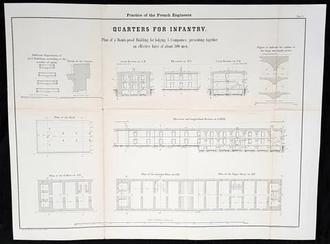
1856 Capt Delafield Large Antique Schematics French Infantry Barracks & Quarters
- Title : Theory and Practice of the French Engineers....Quaters for Infantry..Plan of the Bob Proof Building for lodging 5 Companies presenting together an effective force of about 500 men.
- Date : 1856
- Condition: (A+) Fine Condition
- Ref: 90126
- Size: 26in x 20in (660mm x 500mm)
Description:
This large original lithograph print, schematics of barracks and quarters for infantry in France - during the time of the Crimean War and just prior to the American Civil War - was engraved by John T Bowen & co. of Philadelphia and was published in the 1856 edition of Captain Richard Delafields Report on the Art of War in Europe in 1854, 1855, and 1856.
In early 1855, Captain Richard Delafield was appointed by the Secretary of War, Jefferson Davis, a head of the board of officers, later called The Delafield Commission, and sent to Europe to study the European military. The board included Captain George B. McClellan and Major Alfred Mordecai. They inspected the state of the military in Great Britain, Germany, the Austrian Empire, France, Belgium, and Russia, and served as military observers during the Crimean War. After his return in April 1856, Delafield submitted a report which was later published as a book by Congress, Report on the Art of War in Europe in 1854, 1855, and 1856. The book was suppressed during the American Civil War due to fears that it would be instructive to Confederate engineers as it contained multiple drawings and descriptions of military fortifications.
General Definitions:
Paper thickness and quality: - Light and stable
Paper color : - off white
Age of map color: -
Colors used: -
General color appearance: -
Paper size: - 26in x 20in (660mm x 500mm)
Plate size: - 26in x 20in (660mm x 500mm)
Margins: - Min 1/2in (12mm)
Imperfections:
Margins: - None
Plate area: - Folds as issued
Verso: - Folds re-enforced with archival tape
Background:
The arrival of explosive shells in the 19th century led to yet another stage in the evolution of fortification. Star forts did not fare well against the effects of high explosive and the intricate arrangements of bastions, flanking batteries and the carefully constructed lines of fire for the defending cannon could be rapidly disrupted by explosive shells.
Worse, the large open ditches surrounding forts of this type were an integral part of the defensive scheme, as was the covered way at the edge of the counter scarp. The ditch was extremely vulnerable to bombardment with explosive shells.
In response, military engineers evolved the polygonal style of fortification. The ditch became deep and vertically sided, cut directly into the native rock or soil, laid out as a series of straight lines creating the central fortified area that gives this style of fortification its name.
Wide enough to be an impassable barrier for attacking troops, but narrow enough to be a difficult target for enemy shellfire, the ditch was swept by fire from defensive blockhouses set in the ditch as well as firing positions cut into the outer face of the ditch itself.
The profile of the fort became very low indeed, surrounded outside the ditch covered by caponiers by a gently sloping open area so as to eliminate possible cover for enemy forces, while the fort itself provided a minimal target for enemy fire. The entrypoint became a sunken gatehouse in the inner face of the ditch, reached by a curving ramp that gave access to the gate via a rolling bridge that could be withdrawn into the gatehouse.
Much of the fort moved underground. Deep passages and tunnels now connected the blockhouses and firing points in the ditch to the fort proper, with magazines and machine rooms deep under the surface. The guns, however, were often mounted in open emplacements and protected only by a parapet; both in order to keep a lower profile and also because experience with guns in closed casemates had seen them put out of action by rubble as their own casemates were collapsed around them.
Gone were citadels surrounding towns: forts were to be moved to the outside of the cities some 12 km to keep the enemy at a distance so their artillery could not bombard the city center. From now on a ring of forts were to be built at a spacing that would allow them to effectively cover the intervals between them.
The new forts abandoned the principle of the bastion, which had also been made obsolete by advances in arms. The outline was a much simplified polygon, surrounded by a ditch. These forts, built in masonry and shaped stone, were designed to shelter their garrison against bombardment. One organizing feature of the new system involved the construction of two defensive curtains: an outer line of forts, backed by an inner ring or line at critical points of terrain or junctions (see, for example, Séré de Rivières system in France).
Traditional fortification however continued to be applied by European armies engaged in warfare in colonies established in Africa against lightly armed attackers from amongst the indigenous population. A relatively small number of defenders in a fort impervious to primitive weaponry could hold out against high odds, the only constraint being the supply of ammunition.
Delafield, Richard Major General 1798 - 1873 - Delafield was a United States Army officer for 52 years. He served as superintendent of the United States Military Academy for 12 years. At the start of the American Civil War, then Colonel Delafield helped equip and send volunteers from New York to the Union Army. He also was in command of defences around New York harbor from 1861 to April 1864. On April 22, 1864, he was promoted to Brigadier General in the Regular Army of the United States and Chief of Engineers. On March 8, 1866, President Andrew Johnson nominated Delafield for appointment to the grade of brevet major general in the Regular Army, to rank from March 13, 1865, and the United States Senate confirmed the appointment on May 4, 1866, reconfirmed due to a technicality on July 14, 1866. He retired from the US Army on August 8, 1866. He later served on two commissions relating to improvements to Boston Harbor and to lighthouses. He also served as a regent of the Smithsonian Institution.
Delafield served as assistant engineer in the construction of Hampton Roads defences from 1819–1824 and was in charge of fortifications and surveys in the Mississippi River delta area in 1824-1832. While superintendent of repair work on the Cumberland Road east of the Ohio River, he designed and built Dunlaps Creek Bridge in Brownsville, Pennsylvania, the first cast-iron tubular-arch bridge in the United States. Commissioned a major of engineers in July 1838, he was appointed superintendent of the Military Academy after the fire of 1838 and served till 1845. He designed the new buildings and the new cadet uniform that first displayed the castle insignia. He superintended the construction of coast defences for New York Harbor from 1846 to 1855.
In the beginning of 1855, Delafield was appointed by the Secretary of War, Jefferson Davis a head of the board of officers, later called The Delafield Commission, and sent to Europe to study the European military. The board included Captain George B. McClellan and Major Alfred Mordecai. They inspected the state of the military in Great Britain, Germany, the Austrian Empire, France, Belgium, and Russia, and served as military observers during the Crimean War. After his return in April 1856, Delafield submitted a report which was later published as a book by Congress, Report on the Art of War in Europe in 1854, 1855, and 1856. The book was suppressed during the American Civil War due to fears that it would be instructive to Confederate engineers as it contained multiple drawings and descriptions of military fortifications.
Delafield served as superintendent of the Military Academy again in 1856-1861. In January 1861, he was succeeded by Captain Pierre G. T. Beauregard, who was dismissed shortly after Beauregards home state of Louisiana seceded from the Union, and Delafield returned as superintendent serving until March 1, 1861. In the beginning of the Civil War he advised the governor of New York Edwin D. Morgan during the volunteer force creation. Then, in 1861–1864, he was put in charge of New York Harbor defences, including Governors Island and Fort at Sandy Hook. On May 19, 1864, he was commissioned a brigadier-general after replacing Joseph Gilbert Totten, who had died, as the Chief of Engineers, United States Army Corps of Engineers, on April 22, 1864. He stayed in charge of the Bureau of Engineers of the War Department until his retirement on August 8, 1866. On March 8, 1866, President Andrew Johnson nominated Delafield for appointment to the grade of brevet major general in the Regular Army of the United States, to rank from March 13, 1865, and the United States Senate confirmed the appointment on May 4, 1866 and reconfirmed it due to a technicality on July 14, 1866.After retirement Delafield served as a regent of the Smithsonian Institution and a member of the Lighthouse Board. He died in Washington, D.C. on November 5, 1873.
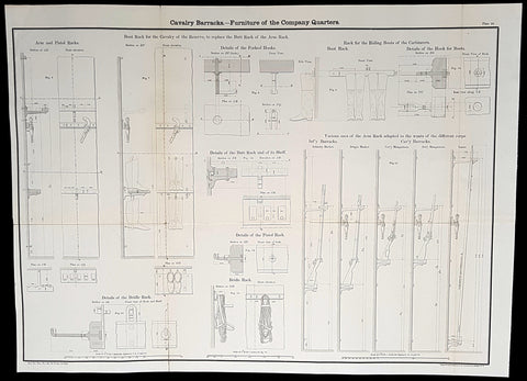
1856 Capt Delafield Large Antique Schematics of Calvary Barracks Rifles, Pistols
- Title : Cavalry Barracks - Furniture of the Company Quarters...
- Date : 1856
- Condition: (A+) Fine Condition
- Ref: 90133
- Size: 26in x 20in (660mm x 500mm)
Description:
This large original lithograph print, schematics of the internals of cavalry barracks and quarters (guns, boots, pistols etc) - during the time of the Crimean War and just prior to the American Civil War - was engraved by John T Bowen & co. of Philadelphia and was published in the 1856 edition of Captain Richard Delafields Report on the Art of War in Europe in 1854, 1855, and 1856.
In early 1855, Captain Richard Delafield was appointed by the Secretary of War, Jefferson Davis, a head of the board of officers, later called The Delafield Commission, and sent to Europe to study the European military. The board included Captain George B. McClellan and Major Alfred Mordecai. They inspected the state of the military in Great Britain, Germany, the Austrian Empire, France, Belgium, and Russia, and served as military observers during the Crimean War. After his return in April 1856, Delafield submitted a report which was later published as a book by Congress, Report on the Art of War in Europe in 1854, 1855, and 1856. The book was suppressed during the American Civil War due to fears that it would be instructive to Confederate engineers as it contained multiple drawings and descriptions of military fortifications.
General Definitions:
Paper thickness and quality: - Light and stable
Paper color : - off white
Age of map color: -
Colors used: -
General color appearance: -
Paper size: - 26in x 20in (660mm x 500mm)
Plate size: - 26in x 20in (660mm x 500mm)
Margins: - Min 1/2in (12mm)
Imperfections:
Margins: - None
Plate area: - Folds as issued
Verso: - Folds re-enforced with archival tape
Background:
The arrival of explosive shells in the 19th century led to yet another stage in the evolution of fortification. Star forts did not fare well against the effects of high explosive and the intricate arrangements of bastions, flanking batteries and the carefully constructed lines of fire for the defending cannon could be rapidly disrupted by explosive shells.
Worse, the large open ditches surrounding forts of this type were an integral part of the defensive scheme, as was the covered way at the edge of the counter scarp. The ditch was extremely vulnerable to bombardment with explosive shells.
In response, military engineers evolved the polygonal style of fortification. The ditch became deep and vertically sided, cut directly into the native rock or soil, laid out as a series of straight lines creating the central fortified area that gives this style of fortification its name.
Wide enough to be an impassable barrier for attacking troops, but narrow enough to be a difficult target for enemy shellfire, the ditch was swept by fire from defensive blockhouses set in the ditch as well as firing positions cut into the outer face of the ditch itself.
The profile of the fort became very low indeed, surrounded outside the ditch covered by caponiers by a gently sloping open area so as to eliminate possible cover for enemy forces, while the fort itself provided a minimal target for enemy fire. The entrypoint became a sunken gatehouse in the inner face of the ditch, reached by a curving ramp that gave access to the gate via a rolling bridge that could be withdrawn into the gatehouse.
Much of the fort moved underground. Deep passages and tunnels now connected the blockhouses and firing points in the ditch to the fort proper, with magazines and machine rooms deep under the surface. The guns, however, were often mounted in open emplacements and protected only by a parapet; both in order to keep a lower profile and also because experience with guns in closed casemates had seen them put out of action by rubble as their own casemates were collapsed around them.
Gone were citadels surrounding towns: forts were to be moved to the outside of the cities some 12 km to keep the enemy at a distance so their artillery could not bombard the city center. From now on a ring of forts were to be built at a spacing that would allow them to effectively cover the intervals between them.
The new forts abandoned the principle of the bastion, which had also been made obsolete by advances in arms. The outline was a much simplified polygon, surrounded by a ditch. These forts, built in masonry and shaped stone, were designed to shelter their garrison against bombardment. One organizing feature of the new system involved the construction of two defensive curtains: an outer line of forts, backed by an inner ring or line at critical points of terrain or junctions (see, for example, Séré de Rivières system in France).
Traditional fortification however continued to be applied by European armies engaged in warfare in colonies established in Africa against lightly armed attackers from amongst the indigenous population. A relatively small number of defenders in a fort impervious to primitive weaponry could hold out against high odds, the only constraint being the supply of ammunition.
Delafield, Richard Major General 1798 - 1873 - Delafield was a United States Army officer for 52 years. He served as superintendent of the United States Military Academy for 12 years. At the start of the American Civil War, then Colonel Delafield helped equip and send volunteers from New York to the Union Army. He also was in command of defences around New York harbor from 1861 to April 1864. On April 22, 1864, he was promoted to Brigadier General in the Regular Army of the United States and Chief of Engineers. On March 8, 1866, President Andrew Johnson nominated Delafield for appointment to the grade of brevet major general in the Regular Army, to rank from March 13, 1865, and the United States Senate confirmed the appointment on May 4, 1866, reconfirmed due to a technicality on July 14, 1866. He retired from the US Army on August 8, 1866. He later served on two commissions relating to improvements to Boston Harbor and to lighthouses. He also served as a regent of the Smithsonian Institution.
Delafield served as assistant engineer in the construction of Hampton Roads defences from 1819–1824 and was in charge of fortifications and surveys in the Mississippi River delta area in 1824-1832. While superintendent of repair work on the Cumberland Road east of the Ohio River, he designed and built Dunlaps Creek Bridge in Brownsville, Pennsylvania, the first cast-iron tubular-arch bridge in the United States. Commissioned a major of engineers in July 1838, he was appointed superintendent of the Military Academy after the fire of 1838 and served till 1845. He designed the new buildings and the new cadet uniform that first displayed the castle insignia. He superintended the construction of coast defences for New York Harbor from 1846 to 1855.
In the beginning of 1855, Delafield was appointed by the Secretary of War, Jefferson Davis a head of the board of officers, later called The Delafield Commission, and sent to Europe to study the European military. The board included Captain George B. McClellan and Major Alfred Mordecai. They inspected the state of the military in Great Britain, Germany, the Austrian Empire, France, Belgium, and Russia, and served as military observers during the Crimean War. After his return in April 1856, Delafield submitted a report which was later published as a book by Congress, Report on the Art of War in Europe in 1854, 1855, and 1856. The book was suppressed during the American Civil War due to fears that it would be instructive to Confederate engineers as it contained multiple drawings and descriptions of military fortifications.
Delafield served as superintendent of the Military Academy again in 1856-1861. In January 1861, he was succeeded by Captain Pierre G. T. Beauregard, who was dismissed shortly after Beauregards home state of Louisiana seceded from the Union, and Delafield returned as superintendent serving until March 1, 1861. In the beginning of the Civil War he advised the governor of New York Edwin D. Morgan during the volunteer force creation. Then, in 1861–1864, he was put in charge of New York Harbor defences, including Governors Island and Fort at Sandy Hook. On May 19, 1864, he was commissioned a brigadier-general after replacing Joseph Gilbert Totten, who had died, as the Chief of Engineers, United States Army Corps of Engineers, on April 22, 1864. He stayed in charge of the Bureau of Engineers of the War Department until his retirement on August 8, 1866. On March 8, 1866, President Andrew Johnson nominated Delafield for appointment to the grade of brevet major general in the Regular Army of the United States, to rank from March 13, 1865, and the United States Senate confirmed the appointment on May 4, 1866 and reconfirmed it due to a technicality on July 14, 1866.After retirement Delafield served as a regent of the Smithsonian Institution and a member of the Lighthouse Board. He died in Washington, D.C. on November 5, 1873.
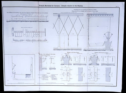
1856 Capt Delafield Large Antique Schematics of French Calvary Barracks, Stables
- Title : French Barracks for Cavalry - Details relative to the Stables
- Date : 1856
- Condition: (A) Very Good Condition
- Ref: 90125
- Size: 26in x 20in (660mm x 500mm)
Description:
This large original lithograph print, internal schematics of the French Cavalry Barracks & Stables - during the time of the Crimean War and just prior to the American Civil War - was engraved by John T Bowen & co. of Philadelphia and was published in the 1856 edition of Captain Richard Delafields Report on the Art of War in Europe in 1854, 1855, and 1856.
In early 1855, Captain Richard Delafield was appointed by the Secretary of War, Jefferson Davis, a head of the board of officers, later called The Delafield Commission, and sent to Europe to study the European military. The board included Captain George B. McClellan and Major Alfred Mordecai. They inspected the state of the military in Great Britain, Germany, the Austrian Empire, France, Belgium, and Russia, and served as military observers during the Crimean War. After his return in April 1856, Delafield submitted a report which was later published as a book by Congress, Report on the Art of War in Europe in 1854, 1855, and 1856. The book was suppressed during the American Civil War due to fears that it would be instructive to Confederate engineers as it contained multiple drawings and descriptions of military fortifications.
General Definitions:
Paper thickness and quality: - Light and stable
Paper color : - off white
Age of map color: -
Colors used: -
General color appearance: -
Paper size: - 26in x 20in (660mm x 500mm)
Plate size: - 26in x 20in (660mm x 500mm)
Margins: - Min 1/2in (12mm)
Imperfections:
Margins: - None
Plate area: - Light age toning along folds as issued
Verso: - Folds re-enforced with archival tape
Background:
The arrival of explosive shells in the 19th century led to yet another stage in the evolution of fortification. Star forts did not fare well against the effects of high explosive and the intricate arrangements of bastions, flanking batteries and the carefully constructed lines of fire for the defending cannon could be rapidly disrupted by explosive shells.
Worse, the large open ditches surrounding forts of this type were an integral part of the defensive scheme, as was the covered way at the edge of the counter scarp. The ditch was extremely vulnerable to bombardment with explosive shells.
In response, military engineers evolved the polygonal style of fortification. The ditch became deep and vertically sided, cut directly into the native rock or soil, laid out as a series of straight lines creating the central fortified area that gives this style of fortification its name.
Wide enough to be an impassable barrier for attacking troops, but narrow enough to be a difficult target for enemy shellfire, the ditch was swept by fire from defensive blockhouses set in the ditch as well as firing positions cut into the outer face of the ditch itself.
The profile of the fort became very low indeed, surrounded outside the ditch covered by caponiers by a gently sloping open area so as to eliminate possible cover for enemy forces, while the fort itself provided a minimal target for enemy fire. The entrypoint became a sunken gatehouse in the inner face of the ditch, reached by a curving ramp that gave access to the gate via a rolling bridge that could be withdrawn into the gatehouse.
Much of the fort moved underground. Deep passages and tunnels now connected the blockhouses and firing points in the ditch to the fort proper, with magazines and machine rooms deep under the surface. The guns, however, were often mounted in open emplacements and protected only by a parapet; both in order to keep a lower profile and also because experience with guns in closed casemates had seen them put out of action by rubble as their own casemates were collapsed around them.
Gone were citadels surrounding towns: forts were to be moved to the outside of the cities some 12 km to keep the enemy at a distance so their artillery could not bombard the city center. From now on a ring of forts were to be built at a spacing that would allow them to effectively cover the intervals between them.
The new forts abandoned the principle of the bastion, which had also been made obsolete by advances in arms. The outline was a much simplified polygon, surrounded by a ditch. These forts, built in masonry and shaped stone, were designed to shelter their garrison against bombardment. One organizing feature of the new system involved the construction of two defensive curtains: an outer line of forts, backed by an inner ring or line at critical points of terrain or junctions (see, for example, Séré de Rivières system in France).
Traditional fortification however continued to be applied by European armies engaged in warfare in colonies established in Africa against lightly armed attackers from amongst the indigenous population. A relatively small number of defenders in a fort impervious to primitive weaponry could hold out against high odds, the only constraint being the supply of ammunition.
Delafield, Richard Major General 1798 - 1873 - Delafield was a United States Army officer for 52 years. He served as superintendent of the United States Military Academy for 12 years. At the start of the American Civil War, then Colonel Delafield helped equip and send volunteers from New York to the Union Army. He also was in command of defences around New York harbor from 1861 to April 1864. On April 22, 1864, he was promoted to Brigadier General in the Regular Army of the United States and Chief of Engineers. On March 8, 1866, President Andrew Johnson nominated Delafield for appointment to the grade of brevet major general in the Regular Army, to rank from March 13, 1865, and the United States Senate confirmed the appointment on May 4, 1866, reconfirmed due to a technicality on July 14, 1866. He retired from the US Army on August 8, 1866. He later served on two commissions relating to improvements to Boston Harbor and to lighthouses. He also served as a regent of the Smithsonian Institution.
Delafield served as assistant engineer in the construction of Hampton Roads defences from 1819–1824 and was in charge of fortifications and surveys in the Mississippi River delta area in 1824-1832. While superintendent of repair work on the Cumberland Road east of the Ohio River, he designed and built Dunlaps Creek Bridge in Brownsville, Pennsylvania, the first cast-iron tubular-arch bridge in the United States. Commissioned a major of engineers in July 1838, he was appointed superintendent of the Military Academy after the fire of 1838 and served till 1845. He designed the new buildings and the new cadet uniform that first displayed the castle insignia. He superintended the construction of coast defences for New York Harbor from 1846 to 1855.
In the beginning of 1855, Delafield was appointed by the Secretary of War, Jefferson Davis a head of the board of officers, later called The Delafield Commission, and sent to Europe to study the European military. The board included Captain George B. McClellan and Major Alfred Mordecai. They inspected the state of the military in Great Britain, Germany, the Austrian Empire, France, Belgium, and Russia, and served as military observers during the Crimean War. After his return in April 1856, Delafield submitted a report which was later published as a book by Congress, Report on the Art of War in Europe in 1854, 1855, and 1856. The book was suppressed during the American Civil War due to fears that it would be instructive to Confederate engineers as it contained multiple drawings and descriptions of military fortifications.
Delafield served as superintendent of the Military Academy again in 1856-1861. In January 1861, he was succeeded by Captain Pierre G. T. Beauregard, who was dismissed shortly after Beauregards home state of Louisiana seceded from the Union, and Delafield returned as superintendent serving until March 1, 1861. In the beginning of the Civil War he advised the governor of New York Edwin D. Morgan during the volunteer force creation. Then, in 1861–1864, he was put in charge of New York Harbor defences, including Governors Island and Fort at Sandy Hook. On May 19, 1864, he was commissioned a brigadier-general after replacing Joseph Gilbert Totten, who had died, as the Chief of Engineers, United States Army Corps of Engineers, on April 22, 1864. He stayed in charge of the Bureau of Engineers of the War Department until his retirement on August 8, 1866. On March 8, 1866, President Andrew Johnson nominated Delafield for appointment to the grade of brevet major general in the Regular Army of the United States, to rank from March 13, 1865, and the United States Senate confirmed the appointment on May 4, 1866 and reconfirmed it due to a technicality on July 14, 1866.After retirement Delafield served as a regent of the Smithsonian Institution and a member of the Lighthouse Board. He died in Washington, D.C. on November 5, 1873.