
John Senex (1690- 1740)
Profile : Publisher and engraver, Senex, was a contemporary of the cartographer Herman Moll and no doubt, to some extent, a rival although his output was rather smaller. In conjunction with Charles Price and James Maxwell he produced some fine maps of the world and the continents as well as loose maps of various countries (1708-14).
Apart from these maps he seems to have had a particular interest in road maps and in 1719 he issued a corrected edition of Ogilby's Britannia in miniature with updated road maps of England and Wales.
John Senex (2)
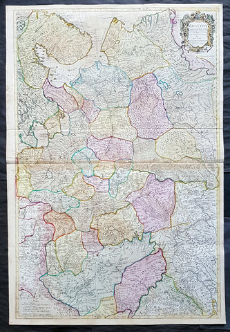
1712 Senex Large Original Antique Map of Europe Russia, Moscow - Finland to Azov
- Title : Moscovy Corrected from ye Observations Communicated to the Royal Society of London and Paris By John Senex & John Maxwell. Sold by them at the Globe.....1712
- Ref #: 82074
- Size: 39 1/2in x 26 1/2in (980mm x 675mm)
- Date : 1712
- Condition: (A) Very Good Condition
Description:
This extraordinary, very large & beautifully hand coloured original antique map of European Russia - Moscovy - including parts of Scandinavia, the Baltic States & The Ukraine by John Senex & John Maxwell in 1712 - dated in title - and was published for Senex's large Elephant Folio General Atlas.
These large scale maps are scarce as damage and loss over time was frequent from both handling and difficulty storing safely.
Background: It is scarcely necessary to look at a map of Russia - with which we must include Siberia - to visualize the daunting task facing Russian map makers. Indeed, considering the vastness of their territory and the lack of skilled cartographers, it is surprising that relatively good maps were available for engraving and printing in most of the well known sixteenth and seventeenth century atlases. Generally, maps of that time were based on material brought back from Moscow by visitors from the West. (Ref: Tooley; M&B)
General Description:
Paper thickness and quality: - Heavy and stable
Paper color: - white
Age of map color: - Original & later
Colors used: - Yellow, green, blue, red
General color appearance: - Authentic
Paper size: - 39 1/2in x 26 1/2in (980mm x 675mm)
Plate size: - 37in x 25in (930mm x 635mm)
Margins: - min. 1/2in (12mm)
Imperfections:
Margins: - None
Plate area: - Light age toning along centerfold & top of image
Verso: - Folds re-enforced on verso
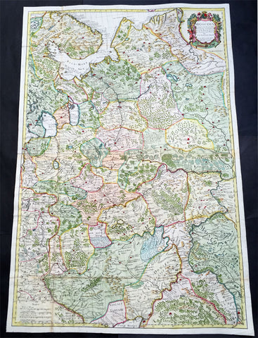
1712 Senex Very Large Antique Map of European Russia - Moscovy Corrected
- Title : Moscovy Corrected from ye Observations Communicated to the Royal Society of London and Paris By John Senex & John Maxwell. Sold by them at the Globe.....1712
- Ref #: 61030
- Size: 38in x 27in (990mm x 665mm)
- Date : 1712
- Condition: (A) Very Good Condition
Description:
This extraordinary, very large & beautifully hand coloured original antique map of European Russia - Moscovy - including parts of Scandinavia, the Baltic States & The Ukraine by John Senex & John Maxwell in 1712 - dated in title - and was published for Senex's large Elephant Folio General Atlas.
These large scale maps are scarce as damage and loss over time was frequent from both handling and difficulty storing safely.
General Description:
Paper thickness and quality: - Heavy and stable
Paper color: - white
Age of map color: - Original & later
Colors used: - Yellow, green, blue, red
General color appearance: - Authentic
Paper size: - 38in x 27in (990mm x 665mm)
Plate size: - 37in x 25in (930mm x 635mm)
Margins: - min. 1/2in (12mm)
Imperfections:
Margins: - None
Plate area: - Folds as issued
Verso: - Folds re-enforced on verso
Background: It is scarcely necessary to look at a map of Russia - with which we must include Siberia - to visualize the daunting task facing Russian map makers. Indeed, considering the vastness of their territory and the lack of skilled cartographers, it is surprising that relatively good maps were available for engraving and printing in most of the well known sixteenth and seventeenth century atlases. Generally, maps of that time were based on material brought back from Moscow by visitors from the West. (Ref: Tooley; M&B)