
John Senex (1690- 1740)
Profile : Publisher and engraver, Senex, was a contemporary of the cartographer Herman Moll and no doubt, to some extent, a rival although his output was rather smaller. In conjunction with Charles Price and James Maxwell he produced some fine maps of the world and the continents as well as loose maps of various countries (1708-14).
Apart from these maps he seems to have had a particular interest in road maps and in 1719 he issued a corrected edition of Ogilby's Britannia in miniature with updated road maps of England and Wales.
John Senex (2)
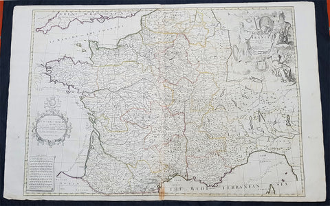
1720 John Senex Large Antique Map of France in Provinces
- Title : France corrected from ye Observations by the Royal Academy Society at Paris by John Senex
- Size: 41 1/2in x 26 1/2in (1.040m x 660mm)
- Condition: (A) Very Good Condition
- Date : 1878
- Ref #: 24903
Description:
This large hand coloured original copper plate engraved antique map of France by John Senex, was published in the 1720 edition of his Elephant Folio Atlas.
This map is in VG condition. These large scale maps are scarce due mainly to their size, with damage and loss over time inevitable.
General Definitions:
Paper thickness and quality: - Heavy and stable
Paper color : - off white
Age of map color: - Original
Colors used: - Yellow, green, blue, pink
General color appearance: - Authentic
Paper size: - 41 1/2in x 26 1/2in (1.040m x 660mm)
Plate size: - 36in x 24 1/2in (915mm x 615mm)
Margins: - Min 1/2in (12mm)
Imperfections:
Margins: - Light chipping to margin edges
Plate area: - Discouloration to bottom centerfold
Verso: - None
Background:
The history of French cartography can be traced to developments in the Middle Ages. This period was marked by improvements in measuring instruments and also by an upgrade of work in registers of all types.
The first map of France was drawn by Oronce Finé and printed in woodcuts in 1525. It testifies to the will of the political power to mark its presence on the territory; to affirm, to build limits, borders, to arrange its territory, and to consolidate the internal economic markets.
In the sixteenth century, Dieppe appeared as an important school of cartography. Pierre Desceliers allowed the realization of many maps. At the same time, the Portolan maps of the Portuguese sailors had the most recent knowledge obtained by the Dieppois sailors in their exploration of Canada.
Then, cartography progressed more and more, through the development of new techniques and by the will of the political powers to control their territories. Very powerful companies testify support to some of the cartographic missions at the end of the nineteenth century.
There were two decisive stages in cartography. One was determining longitude and latitude. Florence Trystram, 2001, the lawsuit of the stars is an account of the research of three French scientists that was done in South America, 1735-1771.
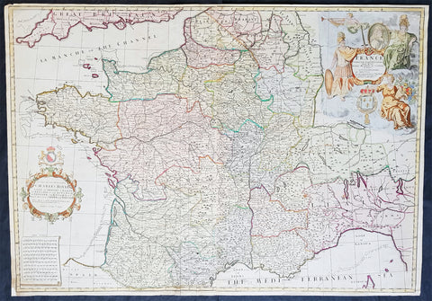
1720 John Senex Large Antique Pre Revolutionary Map of France in Provinces
- Title : France Corrected from ye Observations made by the Royal Academy of Sciences at Paris by John Senex
- Size: 37in x 26in (940m x 660mm)
- Condition: (A) Very Good Condition
- Date : 1720
- Ref #: 81078
Description:
This large beautifully hand coloured original antique map of France was engraved for John Senex for publication in his Elephant Folio Atlas 1720.
These large scale maps are scarce due mainly to their size. Damage and loss over time is inevitable.
General Definitions:
Paper thickness and quality: - Heavy and stable
Paper color : - off white
Age of map color: - Original & later
Colors used: - Yellow, green, blue, pink
General color appearance: - Authentic
Paper size: - 37in x 26in (940m x 660mm)
Plate size: - 36 1/2in x 25 1/2in (930m x 650mm)
Margins: - Min 1/4in (8mm)
Imperfections:
Margins: - Bottom left corner extended from plate-mark
Plate area: - Folds as issued
Verso: - None
Background:
The history of French cartography can be traced to developments in the Middle Ages. This period was marked by improvements in measuring instruments and also by an upgrade of work in registers of all types.
The first map of France was drawn by Oronce Finé and printed in woodcuts in 1525. It testifies to the will of the political power to mark its presence on the territory; to affirm, to build limits, borders, to arrange its territory, and to consolidate the internal economic markets.
In the sixteenth century, Dieppe appeared as an important school of cartography. Pierre Desceliers allowed the realization of many maps. At the same time, the Portolan maps of the Portuguese sailors had the most recent knowledge obtained by the Dieppois sailors in their exploration of Canada.
Then, cartography progressed more and more, through the development of new techniques and by the will of the political powers to control their territories. Very powerful companies testify support to some of the cartographic missions at the end of the nineteenth century.
There were two decisive stages in cartography. One was determining longitude and latitude. Florence Trystram, 2001, the lawsuit of the stars is an account of the research of three French scientists that was done in South America, 1735-1771.