
Johannes Jansson (1588 - 1664)
Profile :
Johannes Janssonius, more commonly known to us as Jan Jansson, was born in Arnhem where his father was a bookseller and publisher (Jan Janszoon the Elder).
In 1612 he married the daughter of the cartographer and publisher Jodocus Hondius, and then set up in business in Amsterdam as a book publisher. In 1616 he published his first maps of France and Italy and from then onwards he produced a very large number of maps, perhaps not quite rivaling those of the Blaeu family but running a very close second in quantity and quality.
From about 1630 to 1638 he was in partnership with his brother-in-law, Henricus Hondius, issuing further editions of the Mercator/Hondius atlases to which his name was added. On the death of Henricus he took over the business, expanding the atlas still further, until eventually he published an 11-volume Atlas Major on a scale similar to Blaeu's Atlas Major.
The first full edition of Jansson's English County Maps was published in 1646 but some years earlier he issued a number of British maps in the Mercator/Hondius/Jansson series of atlases (1636-44); the maps were printed from newly engraved plates and are different from the later 1646 issue and are now rarely seen (see Appendix B for further details). In general appearance Jansson's maps are very similar to those of Blaeu and, in fact, were often copied from them, but they tend to be more flamboyant and decorative.
After Jansson's death his heirs published a number of maps in an Atlas Contractus in 1666, later still many of the plates of his British maps were acquired by Pieter Schenk and Gerard Valck who published them again in 1683 as separate maps
Jan Jansson (2)
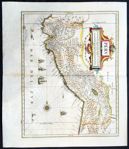
1639 Jan Jansson Antique Map of Peru, South America
- Title : Peru
- Date : 1639
- Condition: (A+) Fine Condition
- Ref: 43147
- Size: 22 1/2in x 20in (570mm x 500mm)
Description:
This finely engraved beautifully hand coloured original antique map of the ancient South American country of Peru was published in the 1639 French edition of Jan Jansson's Atlas Nouvs.
General Description:
Paper thickness and quality: - Heavy and stable
Paper color: - off white
Age of map color: - Original
Colors used: - Green, pink, yellow, blue
General color appearance: - Authentic
Paper size: - 22 1/2in x 20in (570mm x 500mm)
Plate size: - 20in x 15 1/2in (535mm x 395mm)
Margins: - Min 1in (25mm)
Imperfections:
Margins: - Light toning on margin edges
Plate area: - Light creasing along centerfold
Verso: - None
Background:
Jansson in this map shows the Pacific coast of South America from Ecuador - at the left hand side - as far south as the Atacama desert in the northern reaches of Chile.
Although the interior terrain is not mapped with any particular degree of accuracy, this map nevertheless conveys a vivid impression of the difficult terrain of the Andes in Peru.
As early as 1520, Spanish settlers in Panama had heard tales of a powerful civilisation rich in gold that lay to the south, and in 1522 an expedition was organised to find this land and the people called Biru or Piru in the south. In 1524 Francisco Pizarro led the first of his expeditions that led ultimately to the discovery & conquest of the Inca Empire which extended over wide areas of modern Ecuador, Peru, Bolivia and part of Chile. Pizarro obtained from Atahuallpa, the head of the Inca Empire, a huge ransom of silver and gold that made Spain rich almost beyond the most inventive dreams of the Spanish conquerors, and once the mountain city of Cuzco was captured in 1533, the Spanish hold over much of South America was virtually complete.
A beautiful map with a fine impression on clean heavy paper with beautiful hand colouring. (Ref: Tooley, Koeman)
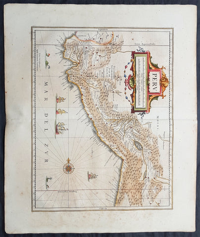
1639 Jan Jansson Original Antique Map of Peru, South America
- Title : Peru
- Date : 1639
- Condition: (A+) Fine Condition
- Ref: 70709
- Size: 24in x 20in (610mm x 510mm)
Description:
This fine, beautifully hand coloured original antique and very important map of Peru, South America by Jan Jansson was published in the 1639 French edition of Gerard Mercators Atlantis Novi Atlas.
General Definitions:
Paper thickness and quality: - Heavy and stable
Paper color : - off white
Age of map color: - Original
Colors used: - Yellow, green, blue, pink
General color appearance: - Authentic
Paper size: - 24in x 20in (610mm x 510mm)
Plate size: - 19 1/2in x 15in (495mm x 390mm)
Margins: - Min 2in (50mm)
Imperfections:
Margins: - Light age toning
Plate area: - Light age toning
Verso: - Light age toning
Background:
Jansson in this map shows the Pacific coast of South America from Ecuador - at the left hand side - as far south as the Atacama desert in the northern reaches of Chile.
Although the interior terrain is not mapped with any particular degree of accuracy, this map nevertheless conveys a vivid impression of the difficult terrain of the Andes in Peru.
As early as 1520, Spanish settlers in Panama had heard tales of a powerful civilisation rich in gold that lay to the south, and in 1522 an expedition was organised to find this land and the people called Biru or Piru in the south. In 1524 Francisco Pizarro led the first of his expeditions that led ultimately to the discovery & conquest of the Inca Empire which extended over wide areas of modern Ecuador, Peru, Bolivia and part of Chile. Pizarro obtained from Atahuallpa, the head of the Inca Empire, a huge ransom of silver and gold that made Spain rich almost beyond the most inventive dreams of the Spanish conquerors, and once the mountain city of Cuzco was captured in 1533, the Spanish hold over much of South America was virtually complete.
A beautiful map with a fine impression on clean heavy paper with beautiful hand colouring. (Ref: Tooley, Koeman)