
Johannes Jansson (1588 - 1664)
Profile :
Johannes Janssonius, more commonly known to us as Jan Jansson, was born in Arnhem where his father was a bookseller and publisher (Jan Janszoon the Elder).
In 1612 he married the daughter of the cartographer and publisher Jodocus Hondius, and then set up in business in Amsterdam as a book publisher. In 1616 he published his first maps of France and Italy and from then onwards he produced a very large number of maps, perhaps not quite rivaling those of the Blaeu family but running a very close second in quantity and quality.
From about 1630 to 1638 he was in partnership with his brother-in-law, Henricus Hondius, issuing further editions of the Mercator/Hondius atlases to which his name was added. On the death of Henricus he took over the business, expanding the atlas still further, until eventually he published an 11-volume Atlas Major on a scale similar to Blaeu's Atlas Major.
The first full edition of Jansson's English County Maps was published in 1646 but some years earlier he issued a number of British maps in the Mercator/Hondius/Jansson series of atlases (1636-44); the maps were printed from newly engraved plates and are different from the later 1646 issue and are now rarely seen (see Appendix B for further details). In general appearance Jansson's maps are very similar to those of Blaeu and, in fact, were often copied from them, but they tend to be more flamboyant and decorative.
After Jansson's death his heirs published a number of maps in an Atlas Contractus in 1666, later still many of the plates of his British maps were acquired by Pieter Schenk and Gerard Valck who published them again in 1683 as separate maps
Jan Jansson (1)
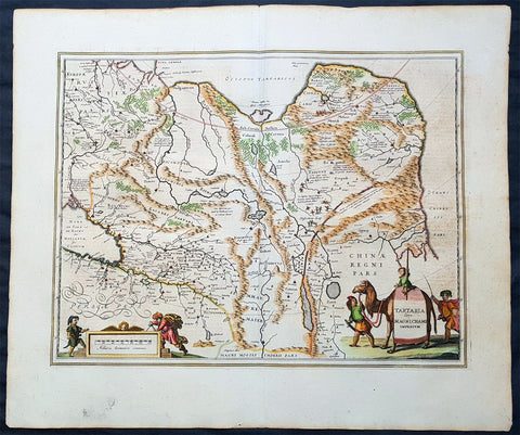
1652 Jan Jansson Antique Map of East & Central Asia, China to Russia - Tartary
- Title : Tartaria sive Magni Chami Imperium
- Date : 1652
- Size: 24in x 20in (610mm x 510mm)
- Ref #: 61166
- Condition: (A+) Fine Condition
Description:
This handsome beautifully hand coloured original antique map of huge region of east & central Asia from China, to Central Asia, The Caspian Sea & parts of European Russia was published by Jan Jansson in the 1652 French edition of Atlas Novus.
Background: This handsome map maps the whole of eastern Central Asia from the Caspian Sea to the Great Wall, Northern China and Manchuria.
This map is dated from a time when Tartaria vaguely meant those regions to the north of Persia, west of China & to the east of Russia. The name Siberia only began to be applied with the gradual eastward expansion of the Russian Cossacks into those areas hinted at in the accounts of Marco Polo from three centuries earlier.
The Mythical and legendary nature of the geography of this vast interior is emphasised by the inclusion of devils and dragons in the Desertum Lop to the left of the Great Wall.
The rest of the map is full of detail both real and myth, some of which is no doubt borrowed from the writings of Marco Polo considered at the time one of the foremost expert on China and Central Asia.
The newly discovered northern coastline of Nova Zembla is shown with a notation concerning the Dutch expedition led by Willem Barents in 1594-96. Interesting in Siberia, Ung quae Gog and Sumongul quae Mogog, which refers to the mythological lands of Gog and Magog. These lands, noted in the Bible as being situated in the remotest parts of the earth, were originally depicted on maps just north of Israel. The map extends west to include the Caspien Sea and Russia, but the primary focus of the map is Tartaria, Central Asia, China and Asiatic Russia. (Ref Tooley M&B)
General Description:
Paper thickness and quality: - Heavy and stable
Paper color: - off white
Age of map color: - Original
Colors used: - Green, red, orange, yellow, blue
General color appearance: - Authentic
Paper size: - 24in x 20in (610mm x 510mm)
Plate size: - 20in x 15 1/4in (510mm x 395mm)
Margins: - Min 1in (25mm)
Imperfections:
Margins: - None
Plate area: - None
Verso: - None