
Johann Baptist Homann (1663 – 1724)
Profile :
Following the long period of Dutch domination in the field of Cartography, the Homann family became the most important map publishers in Germany in the eighteenth century. The business being founded by J.B. Homann in Nuremberg about the year 1702.
Soon after publishing his first atlas in 1707 he became a member of the Berlin academy of Sciences and in 1715 he was appointed Geographer to the Emperor. After the founder’s death in 1724, the firm was continued under the direction of his son until 1730 and was then bequeathed to his heirs on the condition that it trades under the name of Homann Heirs. The firm remained in being until the next century and had a wide influence on map publishing in Germany. Apart from the atlases the firm published a very large number of individual maps.
The Homman’s produced a Neuer Atlas in 1714, a Grosser Atlas in 1737, and an Atlas Maior with about 300 maps in 1780. They also issued a special Atlas of Germany with full sized plans of principal cities, school atlases and an Atlas of Silesia in 1750 with 20 maps.
Johann Baptist Homann (2)
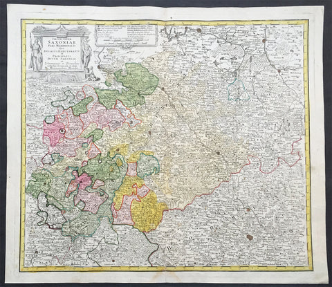
1735 J B Homann Large Antique Map of Old Saxony, Germany - Berlin to Prague
- Title : Circuli Super Saxoniae pars Meridionalis sive Ducatus...Homannianos
- Date : 1735
- Condition: (A+) Fine Condition
- Ref # : 30832
- Size : 23in x 19in (600mm x 520mm)
Description:
This large original hand coloured copper plate engraved antique map of the Saxony region of central Germany. The map stretches from Berlin in the north to Prague in the Czech Republic to the south, by J B Homann was published by the Homann Heirs firm in 1735. (Ref: Tooley; M&B)
General Definitions:
Paper thickness and quality: - Heavy and stable
Paper color : - off white
Age of map color: - Original
Colors used: - Blue, pink, red, green, yellow
General color appearance: - Authentic
Paper size: - 23in x 19in (600mm x 520mm)
Plate size: - 24in x 19 1/2in (565mm x 495mm)
Margins: - Min 1in (25mm)
Imperfections:
Margins: - None
Plate area: - None
Verso: - None
Background:
Saxony is a landlocked federal state of Germany, bordering the federal states of Brandenburg, Saxony Anhalt, Thuringia, and Bavaria, as well as the countries of Poland and the Czech Republic.
The history of the state of Saxony spans more than a millennium. It has been a medieval duchy, an electorate of the Holy Roman Empire, a kingdom, and twice a republic.
The area of the modern state of Saxony should not be confused with Old Saxony, the area inhabited by Saxons. Old Saxony corresponds roughly to the modern German states of Lower Saxony, Saxony-Anhalt, and the Westphalian part of North Rhine-Westphalia.
The territory of the Free State of Saxony became part of the Holy Roman Empire by the 10th century, when the dukes of Saxony were also kings (or emperors) of the Holy Roman Empire, comprising the Ottonian, or Saxon, Dynasty. Around this time, the Billungs, a Saxon noble family, received extensive fields in Saxony. The emperor eventually gave them the title of dukes of Saxony. After Duke Magnus died in 1106, causing the extinction of the male line of Billungs, oversight of the duchy was given to Lothar of Supplinburg, who also became emperor for a short time.
In 1137, control of Saxony passed to the Guelph dynasty, descendants of Wulfhild Billung, eldest daughter of the last Billung duke, and the daughter of Lothar of Supplinburg. In 1180 large portions west of the Weser were ceded to the Bishops of Cologne, while some central parts between the Weser and the Elbe remained with the Guelphs, becoming later the Duchy of Brunswick-Lüneburg. The remaining eastern lands, together with the title of Duke of Saxony, passed to an Ascanian dynasty (descended from Eilika Billung, Wulfhild\\\\\\\'s younger sister) and were divided in 1260 into the two small states of Saxe-Lauenburg and Saxe-Wittenberg. The former state was also named Lower Saxony, the latter Upper Saxony, thence the later names of the two Imperial Circles Saxe-Lauenburg and Saxe-Wittenberg. Both claimed the Saxon electoral privilege for themselves, but the Golden Bull of 1356 accepted only Wittenberg\\\\\\\'s claim, with Lauenburg nevertheless continuing to maintain its claim. In 1422, when the Saxon electoral line of the Ascanians became extinct, the Ascanian Eric V of Saxe-Lauenburg tried to reunite the Saxon duchies.
However, Sigismund, King of the Romans, had already granted Margrave Frederick IV the Warlike of Meissen (House of Wettin) an expectancy of the Saxon electorate in order to remunerate his military support. On 1 August 1425 Sigismund enfeoffed the Wettinian Frederick as Prince-Elector of Saxony, despite the protests of Eric V. Thus the Saxon territories remained permanently separated. The Electorate of Saxony was then merged with the much bigger Wettinian Margraviate of Meissen, however using the higher-ranking name Electorate of Saxony and even the Ascanian coat-of-arms for the entire monarchy. Thus Saxony came to include Dresden and Meissen. In the 18th and 19th centuries Saxe-Lauenburg was colloquially called the Duchy of Lauenburg, which in 1876 merged with Prussia as the Duchy of Lauenburg district.
Saxony-Wittenberg, in modern Saxony-Anhalt, became subject to the margravate of Meissen, ruled by the Wettin dynasty in 1423. This established a new and powerful state, occupying large portions of the present Free State of Saxony, Thuringia, Saxony-Anhalt and Bavaria (Coburg and its environs). Although the centre of this state was far to the southeast of the former Saxony, it came to be referred to as Upper Saxony and then simply Saxony, while the former Saxon territories were now known as Lower Saxony.
In 1485, Saxony was split. A collateral line of the Wettin princes received what later became Thuringia and founded several small states there (see Ernestine duchies). The remaining Saxon state became still more powerful and was known in the 18th century for its cultural achievements, although it was politically weaker than Prussia and Austria, states which oppressed Saxony from the north and south, respectively.
Between 1697 and 1763, the Electors of Saxony were also elected Kings of Poland in personal union.
In 1756, Saxony joined a coalition of Austria, France and Russia against Prussia. Frederick II of Prussia chose to attack preemptively and invaded Saxony in August 1756, precipitating the Third Silesian War (part of the Seven Years\\\\\\\' War). The Prussians quickly defeated Saxony and incorporated the Saxon army into the Prussian army. At the end of the Seven Years\\\\\\\' War, Saxony recovered its independence in the 1763 Treaty of Hubertusburg.
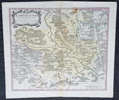
1749 Homann Antique Map Limpurg County, Schwabisch-Hall Baden-Wurtemberg Germany
- Title : Comitatus Limpurgensis Mandato Speciali imperantium mensuratus & hac Tabula geographica comprehensus / In lucem prodit Curis Homannianorum Heredum / Norimb 1749
- Date : 1749
- Condition: (A+) Fine Condition
- Ref: 20428
- Size: 23 1/2in x 20in (595mm x 510mm)
Description:
This large original copper-plate engraved antique map of Limpurg County in the district of Schwäbisch-Hallin in the state of Baden-Wurtemberg, SW Germany by the Homann Heirs was engraved in 1749 - dated in cartouche - and published in the Homanns 1750 German Atlas.
Limpurg is situated in the present-day district of Schwäbisch-Hall or Ostalbkreis between Schwäbisch-Hall, Schwäbisch Gmünd, Aalen and Ellwangen.
The map centers on the river Kocher, with towns marked such as Schwäbisch-Hall (Comburg), Gaildorf, Abstgemünd and Bühlertann.
General Definitions:
Paper thickness and quality: - Heavy and stable
Paper color : - off white
Age of map color: - Original
Colors used: - Yellow, Green, pink
General color appearance: - Authentic
Paper size: - 23 1/2in x 20in (595mm x 510mm)
Plate size: - 21in x 18in (535mm x 460mm)
Margins: - Min 1/4in (5mm)
Imperfections:
Margins: - None
Plate area: - Light soiling
Verso: - None
Background:
Baden-Württemberg is formed from the historical territories of Baden, Prussian Hohenzollern, and Württemberg, and also parts of Swabia.
In 100 AD, the Roman Empire invaded and occupied Württemberg, constructing a limes (fortified boundary zone) along its northern borders. Over the course of the third century AD, the Alemanni forced the Romans to retreat west beyond the Rhine and Danube rivers. In 496 AD the Alemanni were defeated by a Frankish invasion led by Clovis I.
The Holy Roman Empire was later established. The majority of people in this region continued to be Roman Catholics, even after the Protestant Reformation influenced populations in northern Germany. In the late-nineteenth and early-twentieth centuries, numerous people emigrated from this mostly rural area to the United States for economic reasons.