

Joducus Hondius (1563 - 1612) Henricus Hondius, (1587 - 1638)
Joducus Hondius - son (1594 - 1629)
Jodocus Hondius, one of the most notable engravers of his time, is known for his work in association with many of the cartographers and publishers prominent at the end of the sixteenth and the beginning of the seventeenth century.
A native of Flanders, he grew up in Ghent, apprenticed as an instrument and globe maker and map engraver. In 1584, to escape the religious troubles sweeping the Low Countries at that time, he fled to London where he spent some years before finally settling in Amsterdam about 1593. In the London period he came into contact with the leading scientists and geographers of the day and engraved maps in The Mariner's Mirrour, the English edition of Waghenaer's Sea Atlas, as well as others with Pieter van den Keere, his brother-in-law. No doubt his temporary exile in London stood him in good stead, earning him an international reputation, for it could have been no accident that Speed chose Hondius to engrave the plates for the maps in The Theatre of the Empire of Great Britaine in the years between 1605 and 1610.
In 1604 Hondius bought the plates of Mercator's Atlas which, in spite of its excellence, had not competed successfully with the continuing demand for the Ortelius Theatrum Orbis Terrarum. To meet this competition Hondius added about 40 maps to Mercator's original number and from 16o6 published enlarged editions in many languages, still under Mercator's name but with his own name as publisher. These atlases have become known as the Mercator/Hondius series. The following year the maps were re-engraved in miniature form and issued as a pocket Atlas Minor. After the death of Jodocus Hondius the Elder in 1611, work on the two atlases, folio and miniature, was carried on by his widow and sons, Jodocus II and Henricus, and eventually in conjunction with Jan Jansson in Amsterdam. In all, from 1606 onwards, nearly 50 editions with increasing numbers of maps with texts in the main European languages were printed.
Joducus & Henricus Hondius (1)
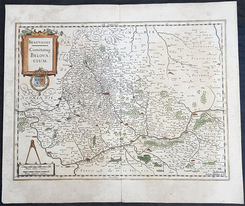
1628 Henricus Hondius Antique Map Beauvais Region of Northern France, Oise River
- Title : Beauvaisis Comitatus Belovacium
- Size: 22in x 18 1/2in (560mm x 470mm)
- Condition: (A) Very Good Condition
- Date : 1628
- Ref #: 50230
Description:
This original hand coloured copper plate engraved antique map of the Beauvais region of Northern France - centering on the city of Beauvais & the Oise River running through the cities of Noyon, Compiègne, Creil, by Henricus Hondius was published by Henricus Hondius & Jan Jansson in the 1628 French edition of Gerard Mercators Atlas.
General Definitions:
Paper thickness and quality: - Heavy and stable
Paper color : - off white
Age of map color: - Original
Colors used: - Blue, pink, red, green, yellow
General color appearance: - Authentic
Paper size: - 22in x 18 1/2in (560mm x 470mm)
Plate size: - 20in x 15in (510mm x 380mm)
Margins: - Min 1in (25mm)
Imperfections:
Margins: - Age toning
Plate area: - Age toning
Verso: - Age toning
Background:
Beauvais is a city and commune in northern France. It serves as the capital of the Oise département, in the Hauts-de-France region. Beauvais is located approximately 75 kilometres from Paris.
Beauvais was known to the Romans by the Gallo-Roman name of Caesaromagus (magos is Common Celtic for field). The post-Renaissance Latin rendering is Bellovacum from the Belgic tribe the Bellovaci, whose capital it was. In the ninth century it became a countship, which about 1013 passed to the bishops of Beauvais, who became peers of France from the twelfth century. At the coronations of kings the Bishop of Beauvais wore the royal mantle and went, with the Bishop of Langres, to raise the king from his throne to present him to the people.
De Bello Gallico II 13 reports that as Julius Caesar was approaching a fortified town called Bratuspantium in the land of the Bellovaci, its inhabitants surrendered to him when he was about 5 Roman miles away. Its name is Gaulish for place where judgements are made, from *bratu-spantion. Some say that Bratuspantium is Beauvais. Others theorize that it is Vendeuil-Caply or Bailleul sur Thérain.
From 1004 to 1037, the Count of Beauvais was Odo II, Count of Blois.
In a charter dated 1056/1060, Eudo of Brittany granted land in pago Belvacensi (Beauvais, Picardy) to the Abbey of Angers Saint-Aubin
In 1346 the town had to defend itself against the English, who again besieged it in 1433. The siege which it endured in 1472 at the hands of the Duke of Burgundy, was rendered famous by the heroism of the towns women, under the leadership of Jeanne Hachette, whose memory is still celebrated by a procession on 27 June (the feast of Sainte Angadrême), during which women take precedence over men.
An interesting hoard of coins from the High Middle Ages became known as the Beauvais Hoard, because some of the British and European coins found with the lot were from the French abbey located in Beauvais. The hoard, which contained a variety of rare and extremely rare Anglo-Norman pennies, English and foreign coins, was reputed to have been found in or near Paris.
Please note all items auctioned are genuine, we do not sell reproductions. A Certificate of Authenticity (COA) can be issued on request.