

Joducus Hondius (1563 - 1612) Henricus Hondius, (1587 - 1638)
Joducus Hondius - son (1594 - 1629)
Jodocus Hondius, one of the most notable engravers of his time, is known for his work in association with many of the cartographers and publishers prominent at the end of the sixteenth and the beginning of the seventeenth century.
A native of Flanders, he grew up in Ghent, apprenticed as an instrument and globe maker and map engraver. In 1584, to escape the religious troubles sweeping the Low Countries at that time, he fled to London where he spent some years before finally settling in Amsterdam about 1593. In the London period he came into contact with the leading scientists and geographers of the day and engraved maps in The Mariner's Mirrour, the English edition of Waghenaer's Sea Atlas, as well as others with Pieter van den Keere, his brother-in-law. No doubt his temporary exile in London stood him in good stead, earning him an international reputation, for it could have been no accident that Speed chose Hondius to engrave the plates for the maps in The Theatre of the Empire of Great Britaine in the years between 1605 and 1610.
In 1604 Hondius bought the plates of Mercator's Atlas which, in spite of its excellence, had not competed successfully with the continuing demand for the Ortelius Theatrum Orbis Terrarum. To meet this competition Hondius added about 40 maps to Mercator's original number and from 16o6 published enlarged editions in many languages, still under Mercator's name but with his own name as publisher. These atlases have become known as the Mercator/Hondius series. The following year the maps were re-engraved in miniature form and issued as a pocket Atlas Minor. After the death of Jodocus Hondius the Elder in 1611, work on the two atlases, folio and miniature, was carried on by his widow and sons, Jodocus II and Henricus, and eventually in conjunction with Jan Jansson in Amsterdam. In all, from 1606 onwards, nearly 50 editions with increasing numbers of maps with texts in the main European languages were printed.
Joducus & Henricus Hondius (1)
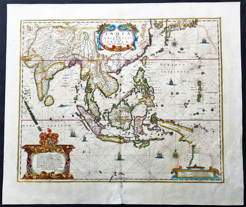
1639 Hondius Antique Map of Australia, East Indies, India to China - Duyfken
- Title : India quae Orientalis dicitur et Insulae Adiacentes
- Date : 1639
- Condition: (A+) Fine Condition
- Ref: 43140
- Size: 22 1/2in x 19 1/4in (570mm x 485mm)
Description:
This fine beautifully hand coloured original antique and very important map of the East Indies, India, SE Asia, China, Japan Philippines and Australia - the first to map the west coast of Cape York Peninsular northern Queensland as well as parts of the SW coast of Western Australia, with place names, was published in the 1639 French edition of Mercators Atlas by Jan Jansson and Henricus Hondius.
An important Dutch map of South East Asia, noteworthy for including the discoveries made in New Guinea and northern Queensland, Australia by the Dutch vessel Duyfken in 1605-06. Under the command of Willem Janzoon, the Duyfken explored the eastern shore of the Gulf of Carpentaria, just below the Cape York Peninsula, a venture which was famously the first recorded European contact with Australia.
Condition Report
Paper thickness and quality: - Heavy and stable
Paper color: - off white
Age of map color: - Original
Colors used: - Red, yellow, green
General color appearance: - Authentic
Paper size: - 22 1/2in x 19 1/4in (570mm x 485mm)
Plate size: - 19 1/4in x 15 1/2in (485mm x 395mm)
Margins: - Min 1in (25mm)
Imperfections:
Margins: - Light age toning
Plate area: - Light offsetting, light age toning
Verso: - Light age toning
Background:
This map of the East Indies extending from India to Japan and south to Australia, shows some of the Dutch discoveries along the West Australian coastline like the Swan River, Nassau River, Coen River and the Batavia River borrows heavily from the exact map by Joan Blaeu. On the eastern part lower right of the map is a small section of Cape York Peninsular. This map is one of the first printed maps to show any part of the Australian coastline. It continued to be an issued unchanged from 1635 up until the 1660's, long after some of the information it contained had been superseded. This was despite the fact that Joan Blaeu as cartographer to the Dutch East India Company from 1638 to 1673 had access to the latest information concerning the extension of the Dutch maritime power in the East Indies, publishing the results of such discoveries (especially of Australia) on large World maps, such as that of 1648. In other words, atlas map's of the East Indies and part of Australia ignores the results of Abel Tasman's discoveries made during the voyage of 1642-44. In 1642, Tasman was appointed commander of an expedition to the South Seas, during which he discovered the Island later named after him as well as part of the coast of New Zealand. His voyage 1644 coasted along the shore of the Gulf of Carpentaria and along the northern coast of Australia as far as the Tropic of Capricorn.
Tasman's discoveries were published very soon afterwards on Blaeu's large World Maps, rendering it all the more curious that the atlas map was never revised. In affect, this map remained an historical map of the archipelago, showing discoveries made. albeit in a rather haphazard and fortuitous manner by the Dutch, between 1606 and 1623.. The design of the map emphasises the importance of the commercial interests in the East Indies, centred as it is on the heart of what was to become The Netherlands East Indies and later Indonesia. (Ref: Koeman; M&B)