

Willem Blaeu (1571 - 1638) Joan Blaeu 1596-1673
Profile :
At the beginning of the seventeenth century Amsterdam was becoming one of the wealthiest trading cities in Europe, the base of the Dutch East India Company and a center of banking and the diamond trade, its people noted for their intellectual skills and splendid craftsmanship.
At this propitious time in the history of the Northern Provinces, Willem Janszoon Blaeu, who was born at Alkmaar in 1571 and trained in astronomy and the sciences by Tycho Brahe, the celebrated Danish astronomer, founded a business in Amsterdam in 1599 as a globe and instrument maker. It was not long before the business expanded, publishing maps, topographical works and books of sea charts as well as constructing globes. His most notable early work was a map of Holland (1604), a fine World Map (1605-06) and Het Licht der Zeevaerdt (The Light of Navigation), a marine atlas, which went through many editions in different languages and under a variety of titles. At the same time Blaeu was planning a major atlas intended to include the most up-to-date maps of the whole of the known world but progress on so vast a project was slow and not until he bought between 30 and 40 plates of the Mercator Atlas from Jodocus Hondius II to add to his own collection was he able to publish, in 1630, a 60-map volume with the title Atlantis Appendix. It was another five years before the first two volumes of his planned world atlas, Atlas Novus or the Theatrum Orbis Terrarum were issued. About this time he was appointed Hydrographer to the East India Company.
In 1638 Blaeu died and the business passed into the hands of his sons, Joan and Cornelis, who continued and expanded their father's ambitious plans. After the death of Cornelis, Joan directed the work alone and the whole series of 6 volumes was eventually completed about 1655. As soon as it was finished he began the preparation of the even larger work, the Atlas Major, which reached publication in 1662 in II volumes (later editions in 9-12 volumes) and contained nearly 6oo double-page maps and 3,000 pages of text. This was, and indeed remains, the most magnificent work of its kind ever produced; perhaps its geographical content was not as up-to-date or as accurate as its author could have wished, but any deficiencies in that direction were more than compensated for by the fine engraving and colouring, the elaborate cartouches and pictorial and heraldic detail and especially the splendid calligraphy.
In 1672 a disastrous fire destroyed Blaeu's printing house in the Gravenstraat and a year afterwards Joan Blaeu died. The firm's surviving stocks of plates and maps were gradually dispersed, some of the plates being bought by F. de Wit and Schenk and Valck, before final closure in about 1695.
It ought to be mentioned here that there is often confusion between the elder Blaeu and his rival Jan J ansson (Johannes Janssonius). Up to about 1619 Blaeu often signed his works Guilielmus Janssonius or Willems Jans Zoon but after that time he seems to have decided on Guilielmus or G. Blaeu.
Willem & Joan Blaeu (4)
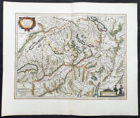
1647 Willem Blaeu Large Antique Map of Switzerland - Helvetia
- Title : Helvetia cum sinitimis regionibus confoederatis
- Ref #: 61109
- Size: 24in x 20in (610mm x 510mm)
- Date : 1647
- Condition: (A+) Fine Condition
Description:
This fine, beautifully hand coloured original antique map* of Switzerland by Willem Blaeu was published in the 1647 Dutch edition of Atlas Novus.
This map, engraved by Blaeu but attributed to Gerard Mercator, is in fine condition with fine original margins, clean stable paper and original colour. A beautiful example of this map by Blaeu after Mercator.
General Description:
Paper thickness and quality: - Heavy and stable
Paper color: - off white
Age of map color: - Original
Colors used: - Yellow, pink, red, blue, green
General color appearance: - Authentic
Paper size: - 24in x 20in (610mm x 510mm)
Plate size: - 20in x 15 1/4in (510mm x 390mm)
Margins: - Min 2in (50mm)
Imperfections:
Margins: - None
Plate area: - None
Verso: - None
Background: The first printed map of Switzerland was published in Martin Waldseemuller's edition of Ptolemy in Strasbourg in 1513, but the manuscript map by Konrad Turst (1497) drawn to scale was a splendid first achievement for its time. Also the research of Vadianus at St Gallen University produced notable work, and along with the Germanic influence in Basle, which became part of the Swiss Confederation in 1501, and the highly developed wood engraving skills there, were important factors in European map publishing.
The almost endless editions of Sebastian Munster's Cosmographia were published in Basle from 1540 for nearly a century and Zurich can claim to have published the first national atlas produced anywhere -that of Johann Stumpf in 1548-52.
By comparison with her larger neighbours, Germany and Italy, Switzerland is considered not to have made a major contribution to Cartographic history. But over the years this has been contradicted, especially starting in the sixteenth century. In the second half of the sixteenth century many maps of the Swiss Cantons, in manuscript or woodcuts appeared, but the mountainous nature of the country produced its own mapping problems and imposed a need for large-scale surveys as well as practical and effective methods of showing land surfaces in relief. Early in the seventeenth century Hans Gyger perfected new ways of doing this but although he published a wide range of very large-scale maps of the cantons and of Switzerland as a whole his techniques did not receive the credit they deserved. On the other hand, his countrymen followed his example of compiling large-scale maps for which they have always been noted for up until the present day. (Ref: Koeman; M&B)
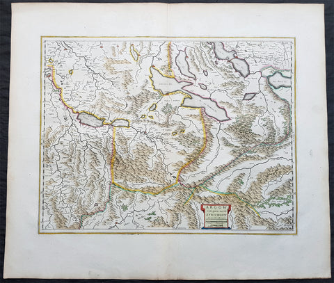
1650 Joan Blaeu Antique Map of The Cantons of Aargau & Zurich, Switzerland
- Title : Argow cum Parte Merid. Zurchgow
- Ref #: 40331
- Size: 24in x 21in (610mm x 535mm)
- Date : 1650
- Condition: (A+) Fine Condition
Description:
This beautifully hand coloured original antique map of the Cantons of Zurich & Aargau in North West Switzerland was published in the 1650 Dutch edition of Joan Blaeus Atlas Novusafter Gerard Mercator.
General Definitions:
Paper thickness and quality: - Heavy and stable
Paper color : - off white
Age of map color: - Original
Colors used: - Blue, pink, red, green, yellow
General color appearance: - Authentic
Paper size: - 24in x 21in (610mm x 535mm)
Plate size: - 21in x 16 1/2in (535mm x 420mm)
Margins: - Min 1in (25mm)
Imperfections:
Margins: - None
Plate area: - None
Verso: - None
Background:
The 26 cantons of Switzerland are the member states of the Swiss Confederation. The nucleus of the Swiss Confederacy in the form of the first three confederate allies used to be referred to as the Waldstätte. Two further major steps in the development of the Swiss cantonal system are referred to by the terms Acht Orte (Eight Cantons; between 1353 and 1481) and Dreizehn Orte (Thirteen Cantons,during 1513–1798); they were important intermediate periods of the Ancient Swiss Confederacy.
Each canton, formerly also Ort (from before 1450), or Stand (estate, from c. 1550), was a fully sovereign state with its own border controls, army, and currency from at least the Treaty of Westphalia (1648) until the establishment of the Swiss federal state in 1848; with a brief period of centralized government during the Helvetic Republic (1798–1803). With the Napoleonic period of the Helvetic Republic the term Kanton was also fully established in German-speaking region.
From 1833, there were 25 cantons, increasing to 26 after the secession of the canton of Jura from Bern in 1979.
The canton of Aargau is one of the more northerly cantons of Switzerland. It is situated by the lower course of the Aare, which is why the canton is called Aar-gau (meaning Aare province). It is one of the most densely populated regions of Switzerland.
The canton of Zürich is a Swiss canton in the northeastern part of the country. It is the most populated canton in the country. Its capital is the city of Zürich. The official language is German. The local Swiss German dialect, called Züritüütsch, is commonly spoken. In English the name of the canton and its capital is often written without an umlaut.
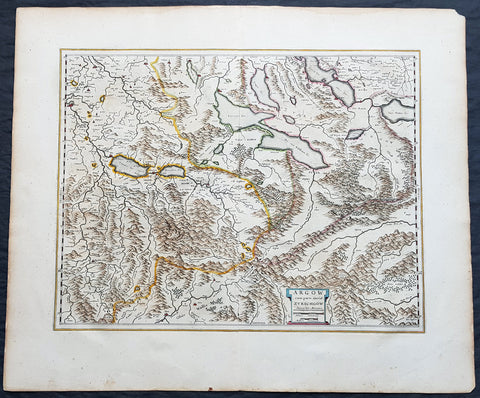
1659 Joan Blaeu Antique Map of The Cantons of Aargau & Zurich, Switzerland
- Title : Argow cum Parte Merid. Zurchgow
- Ref #: 30282
- Size: 24in x 21in (610mm x 535mm)
- Date : 1659
- Condition: (A+) Fine Condition
Description:
This beautifully hand coloured original antique map of the Cantons of Zurich & Aargau in North West Switzerland was published in the 1659 Spanish edition of Joan Blaeus Atlas Novusafter Gerard Mercator.
General Definitions:
Paper thickness and quality: - Heavy and stable
Paper color : - off white
Age of map color: - Original
Colors used: - Blue, pink, red, green, yellow
General color appearance: - Authentic
Paper size: - 24in x 21in (610mm x 535mm)
Plate size: - 21in x 16 1/2in (535mm x 420mm)
Margins: - Min 1in (25mm)
Imperfections:
Margins: - None
Plate area: - None
Verso: - None
Background:
The 26 cantons of Switzerland are the member states of the Swiss Confederation. The nucleus of the Swiss Confederacy in the form of the first three confederate allies used to be referred to as the Waldstätte. Two further major steps in the development of the Swiss cantonal system are referred to by the terms Acht Orte (Eight Cantons; between 1353 and 1481) and Dreizehn Orte (Thirteen Cantons,during 1513–1798); they were important intermediate periods of the Ancient Swiss Confederacy.
Each canton, formerly also Ort (from before 1450), or Stand (estate, from c. 1550), was a fully sovereign state with its own border controls, army, and currency from at least the Treaty of Westphalia (1648) until the establishment of the Swiss federal state in 1848; with a brief period of centralized government during the Helvetic Republic (1798–1803). With the Napoleonic period of the Helvetic Republic the term Kanton was also fully established in German-speaking region.
From 1833, there were 25 cantons, increasing to 26 after the secession of the canton of Jura from Bern in 1979.
The canton of Aargau is one of the more northerly cantons of Switzerland. It is situated by the lower course of the Aare, which is why the canton is called Aar-gau (meaning Aare province). It is one of the most densely populated regions of Switzerland.
The canton of Zürich is a Swiss canton in the northeastern part of the country. It is the most populated canton in the country. Its capital is the city of Zürich. The official language is German. The local Swiss German dialect, called Züritüütsch, is commonly spoken. In English the name of the canton and its capital is often written without an umlaut.
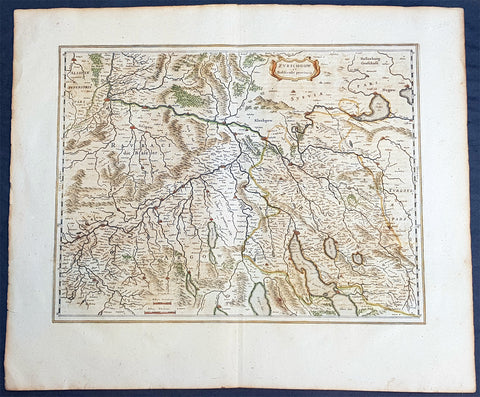
1659 Joan Blaeu Large Antique Map of The Swiss Cantons of Zurich, Aargau & Basel
- Title : Zurichgow et Basiliensis Provincia
- Size: 24 1/2in x 20in (625mm x 510mm)
- Condition: (A+) Fine Condition
- Date : 1659
- Ref #: 30280
Description:
This beautiful original copper plate engraved antique map of the Swiss Canton of Zurich with parts of Aargau & Basel Cantons was published by Joan Blaeu in the rare 1659 Spanish edition of Atlas major
Atlas Major or Great Atlas During the early hours of the 23rd of February 1672, a fire broke out and engulfed a building on Gravenstraat, in the centre of Amsterdam. Such an event at the time was unremarkable, until it was recognised that the fire had brought to an end of one of the greatest publishing houses of all time. Dr Joan Blaeus family were responsible for printing and publishing some of the most important maps, atlases, religious and philosophical books, that are recognised even today, as remarkable. The fire was described in suitably vivid terms in the annual review publication, De Hollandtse Mercurius for 1672-1673
.............the disaster occurred at 3.30 on the morning of the 23rd of February because of the dryness of the timbers, or perhaps the carelessness of the apprentices; the magnificent establishment caught fire, and with it printing type, presses, plates and paper, were all burnt and sparks were sent flying as far as the Tol-heck (Toll Gate). One report put the financial cost of the damage at fl. 27, 000 for the buildings and some fl 355,000 for the plate-stock in the printing works and shop premises, to give total estimated losses of fl. 382, 000 (or about $25milUS in modern terms) together with some four or five thousand reams of paper, five or six thousand sheets, 88 thousand kg. printing type and so on...................
The fire precipitated the end of a publishing house established over 40 years before, and very probably contributed to the death of its proprietor, Alderman Dr Joan Blaeu, a year later, effectively ending the reign of one of the greatest producers of printed maps and atlases in publishing history. Only 10 years previously, in 1662, the house had reached its zenith with the publication of its greatest achievement, the Atlas Major or Great Atlas, containing 11 volumes with geographical detail reflecting many of the achievements of the Golden Age of the United Netherlands.
General Definitions:
Paper thickness and quality: - Heavy and stable
Paper color : - off white
Age of map color: - Original
Colors used: - Blue, pink, red, green, yellow
General color appearance: - Authentic
Paper size: - 24 1/2in x 20in (625mm x 510mm)
Plate size: - 19 1/2in x 15in (500mm x 385mm)
Margins: - Min 2in (50mm)
Imperfections:
Margins: - Light age toning to margin edges
Plate area: - None
Verso: - None
Background:
Switzerland
By comparison with her larger neighbours, Germany and Italy, it may not be considered that Switzerland has made a major contribution to the history of cartography, but in the sixteenth century especially Swiss influence was by no means negligible. Certainly the first printed map of Switzerland was published in Martin Waldseemuller\'s edition of Ptolemy at Strasburg in 1513, but the manuscript map by Konrad Turst (1497) drawn to scale was a splendid achievement for its time and the researches of Vadianus at St Gallen University produced notable work; the Germanic influence in Basle, which became part of the Swiss Confederation in 1501, and the highly developed wood engraving skills there were important factors in European map publishing. The almost endless editions of Munster were published there from 1540 onwards for nearly a century and Zurich can claim to have published the first national atlas produced anywhere -that of Johann Stumpf in 1548-52.
In the second half of the sixteenth century many maps of the cantons in manuscript or woodcut appeared but the mountainous nature of the country produced its own mapping problems and imposed a need for large-scale suAbraham Orteliusbrveys as well as practical and effective methods of showing land surfaces in relief. Early in the seventeenth century Hans Gyger perfected new ways of doing this but although he published a wide range of very large-scale maps of the cantons and of Switzerland as a whole his techniques did not receive the acceptance they deserved. On the other hand his countrymen followed his precedent of compiling large-scale maps for which they have always been noted until the present day. (Ref:Koeman; Tooley)
Please note all items auctioned are genuine, we do not sell reproductions. A Certificate of Authenticity (COA) can be issued on request.