

Willem Blaeu (1571 - 1638) Joan Blaeu 1596-1673
Profile :
At the beginning of the seventeenth century Amsterdam was becoming one of the wealthiest trading cities in Europe, the base of the Dutch East India Company and a center of banking and the diamond trade, its people noted for their intellectual skills and splendid craftsmanship.
At this propitious time in the history of the Northern Provinces, Willem Janszoon Blaeu, who was born at Alkmaar in 1571 and trained in astronomy and the sciences by Tycho Brahe, the celebrated Danish astronomer, founded a business in Amsterdam in 1599 as a globe and instrument maker. It was not long before the business expanded, publishing maps, topographical works and books of sea charts as well as constructing globes. His most notable early work was a map of Holland (1604), a fine World Map (1605-06) and Het Licht der Zeevaerdt (The Light of Navigation), a marine atlas, which went through many editions in different languages and under a variety of titles. At the same time Blaeu was planning a major atlas intended to include the most up-to-date maps of the whole of the known world but progress on so vast a project was slow and not until he bought between 30 and 40 plates of the Mercator Atlas from Jodocus Hondius II to add to his own collection was he able to publish, in 1630, a 60-map volume with the title Atlantis Appendix. It was another five years before the first two volumes of his planned world atlas, Atlas Novus or the Theatrum Orbis Terrarum were issued. About this time he was appointed Hydrographer to the East India Company.
In 1638 Blaeu died and the business passed into the hands of his sons, Joan and Cornelis, who continued and expanded their father's ambitious plans. After the death of Cornelis, Joan directed the work alone and the whole series of 6 volumes was eventually completed about 1655. As soon as it was finished he began the preparation of the even larger work, the Atlas Major, which reached publication in 1662 in II volumes (later editions in 9-12 volumes) and contained nearly 6oo double-page maps and 3,000 pages of text. This was, and indeed remains, the most magnificent work of its kind ever produced; perhaps its geographical content was not as up-to-date or as accurate as its author could have wished, but any deficiencies in that direction were more than compensated for by the fine engraving and colouring, the elaborate cartouches and pictorial and heraldic detail and especially the splendid calligraphy.
In 1672 a disastrous fire destroyed Blaeu's printing house in the Gravenstraat and a year afterwards Joan Blaeu died. The firm's surviving stocks of plates and maps were gradually dispersed, some of the plates being bought by F. de Wit and Schenk and Valck, before final closure in about 1695.
It ought to be mentioned here that there is often confusion between the elder Blaeu and his rival Jan J ansson (Johannes Janssonius). Up to about 1619 Blaeu often signed his works Guilielmus Janssonius or Willems Jans Zoon but after that time he seems to have decided on Guilielmus or G. Blaeu.
Willem & Joan Blaeu (2)

1638 Joan Blaeu Antique Map of America - Americae nova Tabula
- Title : Americae nova Tabula Auct: Guiljesino Blaeuw
- Date : 1638
- Condition: (A) Very Good Condition
- Ref # : 50685
- Size : 23in x 18 1/2in (585mm x 450mm)
Description:
This magnificent, classic hand coloured original antique map of America 2nd State - the quintessential image of 17th America - was published in the 1638 French edition of Joan Blaeus Atlas Novus. This map is in wonderful condition with a few minor repairs as mentioned below.
General Condition:
Paper thickness and quality: - Heavy and stable
Paper color: - White
Age of map color: - Original color
Colors used: - Pink, green, yellow, blue, red
General color appearance: - Authentic & beautiful
Paper size: - 23in x 18 1/2in (585mm x 450mm)
Plate size: - 22in x 16 1/2in (555mm x 415mm)
Margins: - Min 1in (25mm)
Imperfections:
Margins: - Professional repair to centerfold, no loss.
Plate area: - Small professional repair to below Atlantic monster. Center-fold creases & re-joined at bottom, slight separation
Verso: - Creasing and restoration to center-fold, top & left margin, no loss
Background:
Originally issued by Joan Blaeus father, Willem, as early as 1617, this general map of the Americas was one of the longest lived plates in the atlas, having been used as an atlas map since 1630.
Here is the general seventeenth century European view of the Western Hemisphere: the delineation of the coasts and the nomenclature of the Pacific as well as the Atlantic coasts are basically Spanish in origin and follow the maps of the Fleming Abraham Ortelius and his countryman Cornelis Wytfliet. To these, Willem Blaeu inserted, on the east coast, the English names given by the Roanoke colonists in Virginia, and by Martin Frobisher, John Davis and Henry Hudson in the far north. In Florida and along the St Lawrence, Blaeu added the names given by the French settlers, almost the only memorials to their ill-fated venture in Florida during the latter part of the sixteenth century.
When Blaeu first made his map in the early years of the seventeenth century, Europeans still had no real knowledge of the nature of the Mississippi system. From the expedition journals of Hernando de Soto (1539 - 1543) they had inferred an extensive range of mountains trending eastwards to the north of the Gulf of Mexico in la Florida apparently precluding a great river system. The Great Lakes were as yet unknown although by the time Blaeu issued this map in its atlas form in the Huron region together with the hearsay accounts from Coral Indians were becoming well known through his 1632 map of the region. Evidently, this appears to have been unknown to Blaeu at the time, but surprisingly, he never incorporated the information on later printings of the map. The same applies to Manhattan and Long Island as well, despite the fact that only a short distance from Amsterdam, the Leiden academic Johannes D Late had published the first edition of his monumental work on the Americas which provided source material for any number of maps of the Americas throughout the remainder of the century and beyond.
In common with the other general continental maps in Blaeus atlas's, he has provided perspective plans or views of settlements in the Americas, including Havana, St Domingo, Cartagena, Mexico, Cusco, Potisi, I.la Moca in Chile, Rio Janeiro and Olianda in Pharnambucco, as well as the vignette illustrations of native figures taken from the accounts of John White (Virginia) or Hans Staden (Brazil) and others. (Ref: Burden; RGS; Koeman; Tooley)
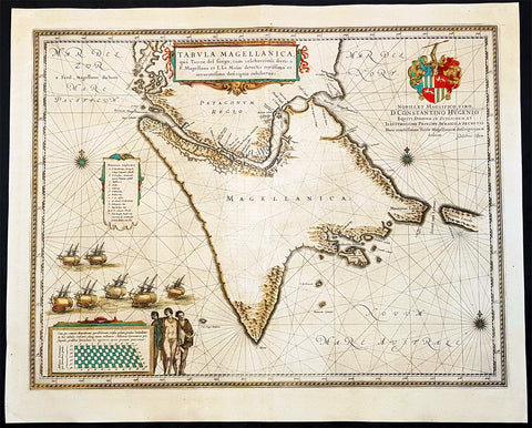
1642 Joan Blaeu Large Antique Map of Tierra Del Fuego & the Magellan Straits, South America
- Title : Tabula Magellanica qua Tierrae del Fuego
- Size: 23in x 19in (585mm x 485mm)
- Condition: (A+) Fine Condition
- Date : 1642
- Ref #: 93352
Description:
This original beautifully hand coloured copper-plate engraved antique map of the Tierra Del Fuego & the Magellan Straits at the very bottom of South America, was published in the 1642 Dutch edition of Joan Blaeus Atlas Nouvs.
General Definitions:
Paper thickness and quality: - Heavy and stable
Paper color : - off white
Age of map color: - Original
Colors used: - Yellow, green, blue, pink
General color appearance: - Authentic
Paper size: - 23in x 19in (585mm x 485mm)
Plate size: - 21in x 16 1/2in (535mm x 420mm)
Margins: - Min 1in (25mm)
Imperfections:
Margins: - Age toning
Plate area: - Age toning
Verso: - Age toning
Background:
Ferdinand Magellan became the first European to navigate the strait in 1520, during his global circumnavigation voyage. Because Magellan\'s ships entered it on November 1, All Saints\' Day, it was originally named Estrecho de Todos los Santos (Strait of All Saints). Later the Spanish king changed the name to Estrecho de Magallanes in honor of Magellan. Since its discovery the Spanish Empire and the Kingdom of Chile saw it as its southern boundary. The first Spanish colonization attempt was led by Pedro Sarmiento de Gamboa who founded Nombre de Jesús and Rey Don Felipe on its northern shores. The cities suffered severe food shortages, and years afterwards in 1587 the English navigator Sir Thomas Cavendish landed at the site of Rey Don Felipe and found only ruins of the settlement. He renamed the place Port Famine. Other early explorers included Francis Drake among others.