
Jean-François de Galaup La Perouse (1741-1788)
La Perouse was born in Albi, France. He entered the navy at 15 and when serving in the Formidable in the battle with Admiral Hawke off Belle-Isle in November 1759 was wounded and captured. Repatriated from England he was posted again to sea duties, where he perfected his techniques as a seaman and navigator and pursued his interest in oceanography. Promoted lieutenant in April 1775 and captain in 1780 after France joined the American war, he had opportunities to distinguish himself as a naval commander. His campaign against the British in Hudson Bay in August 1782 was a signal success, and he demonstrated his humanity by leaving with the remnants of the settlements enough arms and provisions to enable them to preserve themselves during the oncoming winter.
In 1783 the French government resolved to send an expedition to the Pacific to complete Captain James Cook's unfinished work, and in particular to explore the passages in the Bering Sea, which had been a mystery to Europeans since the sixteenth century. King Louis XVI himself took a hand in drafting the plan and itinerary, a copy of which is in the Municipal Library at Rouen, France, and when La Pérouse was selected to lead the fleet gave him an audience before he sailed. In command of two ships, La Boussole and L'Astrolabe (Commandant de Langle), he left Brest on 1 August 1785 making for Brazil. Doubling Cape Horn he refitted in Chile, then sailed to the Sandwich Islands and thence to Alaska, where he turned south exploring and surveying the coast as far as California. After a short refit at Monterey, he sailed across the Pacific, discovered uncharted islands, and visited Macao and Manila. After six weeks reprovisioning and refreshing he left on 10 April 1787 to survey the coasts and territories north of Korea, which had been described and commented on by Christian missionaries. He sailed up the Gulf of Tartary, naming several points on both its shores and learned that Sakhalin was an island. In September he put in to Kamchatka to replenish his supplies. From there he dispatched an officer, Lesseps, overland to Paris with accounts of his discoveries, while he turned south making for New Holland. In December, at Tutuila, Samoa, which Bougainville had called the Navigator Islands when he explored them in 1768, natives suddenly attacked a party from L'Astrolabe seeking water and killed de Langle and eleven others. La Pérouse left without taking reprisals and sailed through the Pacific Islands to Norfolk Island and to Botany Bay. He was sighted off the coast there on 24 January 1788 but bad weather prevented his entering the bay for two days. By then Governor Arthur Phillip had sailed to Port Jackson, but John Hunter had remained with the Sirius and the transports, and assisted La Pérouse to anchor. He established a camp on the northern shore, now called after him, and maintained good relations with the English during his six-week stay. He sailed on 10 March and was not heard of again. His disappearance led the French government in 1791 to equip another expedition under Bruny d'Entrecasteaux to look for him, but the search was fruitless.
As Franco-British relations deteriorated during the revolution unfounded rumours spread in France blaming the British for the tragedy which had occurred in the vicinity of the new colony. It was not until 1828 that the mystery was solved, when Dumont d'Urville ascertained that the La Pérouse expedition was wrecked at Vanikoro, Santa Cruz, north of the New Hebrides. In the meantime the revolutionary government had published the records of the voyage as far as Kamchatka: Voyage De La Pérouse Autour du Monde, 1-4 (Paris, 1797). These volumes are still mines of cartographic and scientific information about the Pacific. Three English translations were published during 1798-99. An anonymous pamphlet Fragmens du Dernier Voyage de la Pérouse (Quimper, 1797), may have been the work of Pére Receveur, a scientist on the expedition who died at Botany Bay on 17 February 1788.
On 17 June 1783 La Pérouse had married Louise-Eléonore Brander of Nantes. They had no children but since his name was taken in 1815 by the husbands of his two sisters, Dalmas and Barthez, it still survives in France.
Jean Francois La Perouse (1)
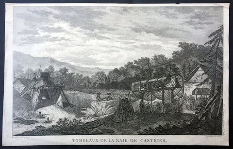
1797 Laperouse Antique Print View De Kastri Bay, Ulchsky Khabarovsk Kai, Russia
- Title : Tombeaux de la Baie de Castries
- Ref : 21436
- Size: 17in x 11in (435mm x 280mm)
- Date : 1797
- Condition: (A+) Fine Condition
Description:
This large original copper plate engraved antique print, a view of the very early settlement at De Kastri Bay, in the Ulchsky District of Khabarovsk Kai, Eastern Russia - opposite the Sakhalin Islands - by Jean-François de Galaup, Comte de la Pérouse was published in the 1st edition of the Atlas du voyage de La Perouse, Paris 1797.
General Definitions:
Paper thickness and quality: - Heavy and stable
Paper color : - off white
Age of map color: -
Colors used: -
General color appearance: -
Paper size: - 17in x 11in (435mm x 280mm)
Plate size: - 17in x 11in (435mm x 280mm)
Margins: - Min 1/2in (12mm)
Imperfections:
Margins: - Small repairs to margins, no loss
Plate area: - None
Verso: - None
Background:
De-Kastri was named for the former name of the bay on which it stands. The bay was discovered by La Pérouse on July 25, 1787 and named after the sponsor of the expedition—the then Secretary of State of the French Navy, the Marquis de Castries. The bay is a convenient natural refuge for vessels, giving it strategic importance from a military viewpoint.
The settlement was officially founded in 1853, although the land where it was situated would not officially be Russian territory until the signing of the Treaty of Aigun five years later.
In 1854, the difficult task of defending Petropavlovsk-Kamchatsky when it came under siege from the British and French forces during the Crimean War brought to attention the difficulties of supply and defense of the Kamchatka Peninsula, where a large section of the Russian Pacific Fleet was based. It was decided to move the port from Kamchatka without waiting for another attack. In the spring of 1855, the Russian navy\'s weapons and sailors under the leadership of Rear Admiral Vasily Zavoyko headed toward the mouth of the Amur River; however, the river mouth was still covered with ice. It was decided to wait for the break-up, hiding in the Bay of de Castries from the superior forces of French and English. Russian ships were discovered there, but managed to escape to the Amur River in the Strait of Tartary before the arrival of enemy reinforcements. The British and French did not know that Sakhalin was an island, and spent the later years of the war waiting in vain for the Russian fleet at its southern coast.