
Jean Baptiste Bourguignon D'Anville (1697-1782)
Profile :
Following the death of Guillaume Delisle, D'Anville continued the line of progressive French cartographers which had begun with Nicolas Sanson in the previous century.
He is said to have designed his first map at the age of fifteen and in a long and active life he produced a great number of elegantly engraved maps, noted for their scholarship and accuracy. If anything, he was even more critical of the work of his predecessors than Delisle and his exacting standards soon brought him international recognition as the finest cartographer of his time. In fact, during his whole life he never travelled outside Paris but he built up a vast collection of cartographic material which eventually was passed to the Bibliotheque Nationale.
He was specially interested in the geography of the East and he designed maps for a Description geographique de Ia Chine by Pere J. B. du Halde (1735), a notable work of the day based on surveys and reports of Jesuit missionaries. These maps were also issued in Nouvel Atlas de Ia Chine in 1737 and were the first to give a reasonably accurate picture of that remote land. From about 1740 onwards he published collections of maps under the title Atlas Generate which went through numerous expanding editions in various languages; English editions were printed by Robert Sayer, Laurie and Whittle, and others into the next century
Jean Baptiste Bourguignon d' Anville (1)
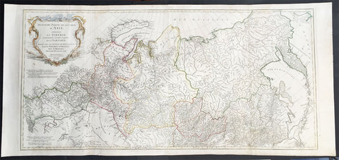
1762 D Anville Very Large Antique Map of Russia, Siberia, Mongolia, China, Japan
- Title : Troisieme Partie De La Carte D' Asia Contenant La Siberie...MDCCLII
- Ref #: 50604
- Size: 55in x 22 1/2in (1.25m x 570mm)
- Date : 1762
- Condition: (A+) Fine Condition
Description:
This very large beautifully engraved hand coloured original antique map of Russia, Siberia and Central Asia was engraved by Jean-Baptiste Bourguinon D'Anville in 1762 - the date is engraved in the title - and was published in the large elephant folio atlas Atlas Generale.
These maps are hard to find in such good condition and make fantastic historical reference tools due to the size and high level of detail as with all D'Anvilles work. (Ref: Tooley, M&B)
General Description:
Paper thickness and quality: - Heavy and stable
Paper color: - White
Age of map color: - Original
Colors used: - Yellow, pink, green
General color appearance: - Authentic
Paper size: - 55in x 22 1/2in (1.25m x 570mm)
Plate size: - 43in x 21in (1.10mm x 535mm)
Margins: - Min 1in (25mm)
Imperfections:
Margins: - None
Plate area: - Light creasing & soiling along L&R folds
Verso: - None