
Herman Moll (1678 – 1732)
A Dutch emigre who came to London about 1680 following the Scanian Wars, he first worked as an engraver for Moses Pitt, later setting up his own business and becoming, after the turn of the century, the foremost map publisher in England.
As his fame grew he became a well known figure at in the group of Intelligencia who gathered at Jonathon's Coffee House in Exchange Alley or Change Alley. This narrow alleyway connecting shops and coffeehouses in an old neighbourhood of the City of London, served as a convenient shortcut from the Royal Exchange on Cornhill to the Post Office on Lombard Street. Shops once located in Exchange Alley included ship chandlers, makers of navigation instruments such as telescopes, and goldsmiths from Lombardy in Italy. The coffeehouses of Exchange Alley, especially Jonathan's and Garraway's, became an early venue for the lively trading of shares and commodities. Moll was able to obtain crucial information from the lively commercial scene in the area.
Moll was at the forefront of mapmaking during his working life and his maps reflect his ever inquisitive nature.
Herman Moll (1)
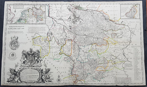
1720 Moll Large Antique Map Brunswick Luneburg, NW Germany - Dedicated to George I
- Title : A New & Exact Map of the Electorate of Brunswick-Lunenburg and ye rest of ye Kings Dominions in Germany, very much Improved by ye kind Assistance of severall Curious Gentlemen . . . To His Most Sacred Majesty George King of Great Britain, France and Ireland, Elector of Brunswick-Lunenburg &c
- Size: 41in x 24 1/2in (1.015m x 620mm)
- Condition: (A+) Fine Condition
- Date : 1720
- Ref #: 93043
Description:
This very large beautifully hand coloured original superbly executed copper-plate engraved antique map of the Electorate of Brunswick Luneburg in NW Germany, by Herman Moll, was published in 1720 in the atlas The World Described, or a New and Correct Sett of Maps by John Bowles, Thomas Bowles, Philip Overton & John King of London.
In the 18th century many large-scale maps were published by the likes of John Senex and Herman Moll, this trend continued until the end of private mapping in the early 19th century when it was replaced by Ordnance Survey maps.
General Definitions:
Paper thickness and quality: - Heavy and stable
Paper color : - off white
Age of map color: - Original
Colors used: - Yellow, green, blue, pink
General color appearance: - Authentic
Paper size: - 41in x 24 1/2in (1.015m x 620mm)
Plate size: - 41in x 24 1/2in (1.015m x 620mm)
Margins: - Min 1/2in (12mm)
Imperfections:
Margins: - Age toning along top margin
Plate area: - Folds as issued
Verso: - Backed onto original haevy paper
Background:
Fine decorative map of Brunswick-Lunenburg and environs, dedicated to King George I, of Great Britain, who was also an Elector of the Holy Roman Empire, and Ruler of the Duchy and Electorate of Brunswick-Luneburg.
At top center is the estuarial northern part of the Elbe River facing Hamburg, while Hanover appears near the center of the map.
Molls depiction of the royal arms and other embellishments surrounding the cartouche display his considerable engraving talents.
Published shortly after King George I ascendancy to the throne as King of England, in 1714, the map marks one of the more fascinating chapters in British History and a turning point in the history and power structure of the British Monarchy.
The Inset maps show:
1. Part of England
2. Netherlands
3. Part of Germany (showing route of the King from Hannover to Greenwich)
4. Duchy of Saxon Lauwenburg
King George I
George I (1660 - 1727), was King of Great Britain and Ireland from August 1, 1714, until his death, and ruler of the Duchy and Electorate of Brunswick-Lüneburg (Hanover) in the Holy Roman Empire, from 1698.
George was born in Hanover and inherited the titles and lands of the Duchy of Brunswick-Lüneburg from his father and uncles. A succession of European wars expanded his German domains during his lifetime and in 1708 he was ratified as prince-elector of Hanover.
At the age of 54, after the death of Queen Anne of Great Britain, George ascended the British throne as the first monarch of the House of Hanover. Although over fifty Roman Catholics bore closer blood relationships to Anne, the Act of Settlement 1701 prohibited Catholics from inheriting the British throne.
George was Anne\'s closest living Protestant relative. In reaction, Jacobites attempted to depose George and replace him with Anne\'s Catholic half-brother, James Francis Edward Stuart, but their attempts failed.
During George\'s reign, the powers of the monarchy diminished and Britain began a transition to the modern system of cabinet government, led by a prime minister. Towards the end of his reign, actual power was held by Sir Robert Walpole, now recognized as Britain\'s first de facto prime minister.