Fries was a French physician and mathematician born in Mulhouse, Germany. He was instrumental in publishing four edition of the Claude Ptolemy Atlas, from text, in 1522 reissued in 1525 which resulted in two further editions, after his death, in 1535 and 1541.
After having successfully completed his education Fries established himself as a physician in the Alsace region and after a short spell in Switzerland, settled in Strasbourg in 1519.
By this time, he had also established a reputation as a writer of medical publications. It was through these publications that Fries met the Strasbourg printer and publisher Johann Grüninger. Gruninger was associated with a group of scholars including, Walter Lud, Martin Ringmann and Martin Waldseemuller.
By the time they met, Gruninger was responsible for printing several of the maps prepared by Waldseemuller for the 1513 edition of Ptolemy.
This meeting was an important digression into Fries' life. From about 1520 to about 1525, he worked in some capacity as a cartographic editor for or with Gruninger, exploiting the copious amount of material that Waldseemuller had created.
Fries' first venture into map-making was in 1520 helping to produce a reduced version of Waldseemuller's 1507 Ptolemaic World map, which bore Fries monogram. While it would appear that Fries was the editor of the map, credit is actually given in the title to Peter Apian. There is no evidence of Fries being the engraver either, which might have offered an alternative explanation for the appearance of his monogram. The two other monograms that appear are of Johann Camers, editor of the book containing the map, and Luca Alantse, the publisher. The map is entitled Tipus Orbis Universalis Iuxta Ptolomei Cosmographi Traditionem Et Americ Vespucii Aliorque Lustrationes A Petro Apiano Leysnico Elucubrat. An.o Dni MDXX and was issued in Caius Julius Solinus' Enarrationes, edited by Camers, published in Vienna in 1520. In view of Fries' connection with Gruninger, it seems likely that the map was cut in Grüninger's workshop.
In 1522 Fries and Gruninger worked on a new edition of Geographia which was published by Johann Koberger. Here again, Fries evidently edited the maps reducing maps from the 1513 edition of the Geographie Opus Novissima, printed by Johann Schott. Fries also prepare three new maps for this publication, South-East Asia & the East Indies, China and the World. Again though, the geography for the three maps, were derived from Waldseemuller's 1507 world map.
Karrow noted "Grüninger had high hopes for this edition, one of the grandest publications from his press, in a period when it was not known for producing grand books. The edition suffered, however, from a great many textual errors ... Nevertheless, the book sold well enough to justify a new edition three years later..."
In fact, the comparative rarity of the 1522 edition would actually seem to suggest the opposite - that the edition was not well received, and that sales were poor. For example, A.E Nordenskiold, who attempted to collect examples of each edition of Ptolemy's text illustrated with maps, was not able to secure an example of this 1522 edition for his collection (in spite of his willingness to buy defective examples of volumes that he sought)
Instead, it would appear that Grüninger sought to recoup his investment by preparing an improved edition, and to this end, he sought the assistance of Wilibald Pirkheimer to re-edit the text, using the notes of Johannes Regiomontanus. The new edition was ready in 1525. As Karrow notes, the press-work was not of a high standard, and Pirckheimer was generally dissatisfied with the finished book.
After Grüninger's death in 1531, the business was continued by his son Christoph, who seems to have sold the materials for the Ptolemy to two Lyons publishers, the brothers Melchior and Gaspar Trechsel, who published a joint edition in 1535, before Gaspar Trechsel published an edition in his own right in 1541.
These two editions were edited by Michael Servetus (or Villanovus), a Spanish doctor resident in Lyons. In those difficult times, Servetus was accused of heresy. One piece of evidence used against him was a passage on the reverse of the modern map of the Holy Land, which said that "Palestine was not such a fertile land as was generally believed, since modern travellers reported it barren". Unfortunately, this not Servetus' original view, but was a passage repeated from the 1522 edition.
This charge seems to have counted against Servetus for, when he was burnt at the stake, Calvin ordered that copies of the book should be burnt with him. This has often been cited as a justification to describe examples of the 1535 and 1541 editions as the rarest of the four. However, it should be remembered that Servetus was executed in 1553, twelve years after publication of the final edition, so images of the entire print-run being destroyed are exaggerated. In fact, the 1535 and 1541 editions are the two editions most commonly encountered, both in libraries and on the market, which would suggest the Calvinist authorities may only have burnt a few token copies.
Having completed the 1522 edition of Ptolemy, Fries turned his attention to the last of Waldseemuller's great cartographic works, his wall-map of the world, published in 1516. Once again, Fries worked on preparing a reduction of that map, although his copy is only slightly smaller than the original. Fries' version was apparently ready in 1525, but no example of that first printing is known today, although fragments are to be found at Leiden University Library.
A complete example of a 1530 printing, bearing the imprint 'Carta Marina Universalis Emendata Et Veritati Resauarat Laurentio Frisio Anno 1530' is to be found in the Bayerische Staatsbibliotek, Munich , while a 1531 printing was issued by Grüninger's son, Christoph.
To accompany the map, Fries prepared a booklet Uslegung der Mercarthen oder Carta Marina..., of which the earliest example known is dated 1525. The existence of other editions, dated 1527 and 1530, may imply parallel editions of the map, but are unknown today.
In 1525, Fries was forced to leave Metz. It would seem likely, as his known output is so derivative of Waldseemuller, that the arrangement with Grüninger had reached a natural conclusion. During the five years, Fries had exhausted the existing body of Waldseemuller's works. For whatever reason this departure marked the end of his cartographic work, and he again turned to writing medical text books, which occupied him until his death in 1531 or 1532.
Laurent Fries (3)
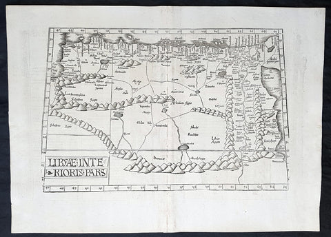
1525 Laurent Fries Antique Map NE Africa Red Sea, Egypt, Nile River Delta, Libya
- Title : Libyae Interioris Pars....Tabula III Aphricae
- Ref #: 93378
- Size: 22 1/2in x 16 1/2in (565mm x 420mm)
- Date : 1525
- Condition: (A+) Fine Condition
Description:
This rare very early original wood-block engraved antique Ptolemaic map of North East Africa from The Red Sea, Egypt, The Nile Delta & Libya by Laurent Fries was published by in the 1525 Strasbourg edition of Ptolemys Geographia
Striking early map of North Africa and Egypt, from the Red Sea, the Nile and Egypt to the Gulf of Libya. Extends up rivers along the Nile to Aden.
Latin text and elaborate decorations on the verso. A nice example, from the 1525 edition of Fries Atlas. First published in Strasbourg by Johannes Gruninger in 1522, Fries map is based upon Waldseemullers map of 1513.
Lorenz (Laurent) Fries was born in Alsace in about 1490. He studied medicine, apparently spending time at the universities of Pavia, Piacenza, Montpellier and Vienna. After completing his education, Fries worked as a physician in several places, before settling in Strassburg, in about 1519. While n Strassburg, Fries met the Strasbourg printer and publisher Johann Grüninger, an associate of the St. Die group of scholars formed by, among others, Walter Lud, Martin Ringmann and Martin Waldseemuller.
From 1520 to 1525, Fries worked with Gruninger as a cartographic editor, exploiting the corpus of material that Waldseemuller had created. Fries first venture into mapmaking was in 1520, when he executed a reduction of Martin Waldseemullers wall-map of the World, published in 1507. While it would appear that Fries was the editor of the map, credit is actually given in the title to Peter Apian. The map, Tipus Orbis Universalis Iuxta Ptolomei Cosmographi Traditionem Et America Vespucii Aliorque Lustrationes A Petro Apiano Leysnico Elucubrat. An.o Dni MDXX, and was issued in Caius Julius Solinus Enarrationes, edited by Camers, and published in Vienna in 1520.
Fries next project that Fries was a new edition of the Geographia of Claudius Ptolemy, which was published by Johann Koberger in 1522. Fries evidently edited the maps, in most cases simply producing a reduction of the equivalent map from Waldseemullers 1513 edition of the Geographie Opus Novissima, printed by Johann Schott. Fries also prepare three new maps for the Geographie: maps of South-East Asia and the East Indies, China and the World, but the geography of these derives from Waldseemullers world map of 1507.
The 1522 edition of Fries work is very rare, suggesting that the work was not commercially successful. In 1525, an improved edition was issued, with a re-edit of the text by Wilibald Pirkheimer, from the notes of Johannes Regiomontanus. After Grüningers death in 1531, the business was continued by his son Christoph, who seems to have sold the materials for the Ptolemy to two Lyon publishers, the brothers Melchior and Gaspar Trechsel, who published a joint edition in 1535, before Gaspar Trechsel published an edition in his own right in 1541.
General Definitions:
Paper thickness and quality: - Heavy and stable
Paper color : - off white
Age of map color: -
Colors used: -
General color appearance: -
Paper size: - 22 1/2in x 16 1/2in (565mm x 420mm)
Plate size: - 18 1/2in x 12 1/2in (475mm x 320mm)
Margins: - Min 1 1/2in (20mm)
Imperfections:
Margins: - None
Plate area: - Light soiling along centerfold
Verso: - None
Background:
Claude Ptolemy - a Greek mathematician, astronomer and geographer, living in Alexandria, assembled and codified his predecessors\' cartographic theories including those of Strabo & Marinus of Tyre (c. AD 120) to whom he was especially indebted. In about AD 150 he published his Geographia, a work in 8 volumes, supposedly illustrated with a world map, 26 regional maps and a profusion of smaller maps. Although the text of the Geographia survived, no maps older than about the twelfth century have come down to us and, in consequence, we have no means of knowing whether the \'Ptolemy\' maps on which we set so much store were, in fact, drawn by him or were the interpretations of later map makers using his text as a basis.
In Europe the initial awakening of interest in geography arose from the revival of knowledge of Ptolemy\'s Geographia soon after the year 1400. Greek manuscript copies made in the twelfth to fourteenth centuries were brought by scholars to Italy from Constantinople and were subsequently translated into Latin and widely studied. This work coincided with, and was much influenced by, the development of printing techniques, particularly, of course, by the invention of movable-type printing by Gutenberg about 1450, which made possible for the first time the production of printed books in quantity. Apart from this factor, other more far-reaching influences were compelling the peoples of Western Europe to look beyond the horizon they had known for so many centuries. With the conquest of Constantinople in 1453 the Turks effectively closed Europe\'s trade routes to the East and shut off access to traditional sources of luxuries and precious metals from Asia and, above all, denied the supply of the spices which had become so important in the lives of ordinary people. Other factors often based on long-believed myths and legends added to the urge to break out into the unknown world.
The interpretation of Ptolemy\'s text began mainly with the Italians Angelus, Beroaldus & Vadius in 1477 and was re-interpreted and re-issued by many over the next century by the likes Waldseemuller 1513, Gastaldi 1548, Mercator 1578 & Magini 1596. (Ref: Tooley; M&B; Dover)
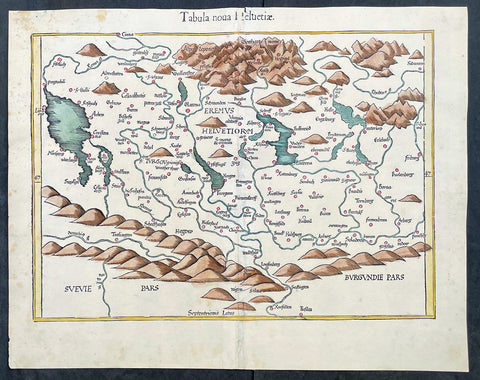
1541 Laurent Fries Very Early, Rare Antique Map of Switzerland
- Title : Tabula noua Helvetiae
- Ref #: 17008
- Size: 18 1/2in x 15in (475mm x 380mm)
- Date : 1541
- Condition: (A+) Fine Condition
Description:
This rare, very early original hand coloured wood-block engraved antique Ptolemaic map of Switzerland by Laurent Fries was published by Trechsel, Gaspar; Vienne, Dauphine in the 1541 Lyon edition of Ptolemys Geographia, Claudii Ptolemaei Alexandrini Geographicae Enarrationis, Libri Octo
General Definitions:
Paper thickness and quality: - Heavy and stable
Paper color : - off white
Age of map color: - Early
Colors used: - Yellow, orange
General color appearance: - Authentic
Paper size: - 18 1/2in x 15in (475mm x 380mm)
Plate size: - 18 1/2in x 15in (475mm x 380mm)
Margins: - Min 1in (25mm)
Imperfections:
Margins: - Small repair to top margin in title
Plate area: - None
Verso: - None
Background:
The first printed map of Switzerland was published in Martin Waldseemuller's edition of Ptolemy in Strasbourg in 1513, but the manuscript map by Konrad Turst (1497) drawn to scale was a splendid first achievement for its time. Also the research of Vadianus at St Gallen University produced notable work, and along with the Germanic influence in Basle, which became part of the Swiss Confederation in 1501, and the highly developed wood engraving skills there, were important factors in European map publishing.
The almost endless editions of Sebastian Munster's Cosmographia were published in Basle from 1540 for nearly a century and Zurich can claim to have published the first national atlas produced anywhere -that of Johann Stumpf in 1548-52.
By comparison with her larger neighbours, Germany and Italy, Switzerland is considered not to have made a major contribution to Cartographic history. But over the years this has been contradicted, especially starting in the sixteenth century. In the second half of the sixteenth century many maps of the Swiss Cantons, in manuscript or woodcuts appeared, but the mountainous nature of the country produced its own mapping problems and imposed a need for large-scale surveys as well as practical and effective methods of showing land surfaces in relief. Early in the seventeenth century Hans Gyger perfected new ways of doing this but although he published a wide range of very large-scale maps of the cantons and of Switzerland as a whole his techniques did not receive the credit they deserved. On the other hand, his countrymen followed his example of compiling large-scale maps for which they have always been noted for up until the present day. (Ref: Koeman; M&B)
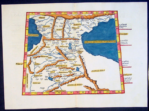
1541 Fries Ptolemaic Antique Map of the Caucasus - Georgia, Armenia, Azerbaijan
- Title : Tabula Tertia Asiae complectitur Colchidem, Iberiam, Alberiam & Armeniam maiorem
- Date : 1541
- Condition: (A+) Fine Condition
- Ref: 92814
- Size: 20 1/2in x 15in (520mm x 380mm)
Description:
This beautifully hand coloured original antique Ptolemaic map by Laurent Fries of the Caucasus region of central Asia - straddling the Black & Caspian Seas (what is today part of the Russian Federation and includes the countries of Georgia, Armenia, Azerbaijan, north-western Iran & north-eastern Turkey) - was published by in the 1541 Vienna edition of Ptolemy's Geographia
General Definitions:
Paper thickness and quality: - Heavy and stable
Paper color : - off white
Age of map color: - Early
Colors used: - Yellow, green, red, blue.
General color appearance: - Authentic
Paper size: - 20 1/2in x 15in (520mm x 380mm)
Plate size: - 20 1/2in x 15in (520mm x 380mm)
Margins: - Min 1in (25mm)
Imperfections:
Margins: - None
Plate area: - None
Verso: - None
Background:
Claude Ptolemy - a Greek mathematician, astronomer and geographer, living in Alexandria, assembled and codified his predecessors' cartographic theories including those of Strabo & Marinus of Tyre (c. AD 120) to whom he was especially indebted. In about AD 150 he published his Geographia, a work in 8 volumes, supposedly illustrated with a world map, 26 regional maps and a profusion of smaller maps. Although the text of the Geographia survived, no maps older than about the twelfth century have come down to us and, in consequence, we have no means of knowing whether the 'Ptolemy' maps on which we set so much store were, in fact, drawn by him or were the interpretations of later map makers using his text as a basis.
In Europe the initial awakening of interest in geography arose from the revival of knowledge of Ptolemy's Geographia soon after the year 1400. Greek manuscript copies made in the twelfth to fourteenth centuries were brought by scholars to Italy from Constantinople and were subsequently translated into Latin and widely studied. This work coincided with, and was much influenced by, the development of printing techniques, particularly, of course, by the invention of movable-type printing by Gutenberg about 1450, which made possible for the first time the production of printed books in quantity. Apart from this factor, other more far-reaching influences were compelling the peoples of Western Europe to look beyond the horizon they had known for so many centuries. With the conquest of Constantinople in 1453 the Turks effectively closed Europe's trade routes to the East and shut off access to traditional sources of luxuries and precious metals from Asia and, above all, denied the supply of the spices which had become so important in the lives of ordinary people. Other factors often based on long-believed myths and legends added to the urge to break out into the unknown world.
The interpretation of Ptolemy's text began mainly with the Italians Angelus, Beroaldus & Vadius in 1477 and was re-interpreted and re-issued by many over the next century by the likes Waldseemuller 1513, Gastaldi 1548, Mercator 1578 & Magini 1596. (Ref: Tooley; M&B; Dover)