
Claude Ptolemy (150AD)
Background:
"Geographia," written by Claudius Ptolemy in the 2nd century AD, is a landmark work in the history of geography and cartography. The book is divided into eight volumes, with the first two providing an introduction and a discussion of map projection techniques. The remaining six volumes contain detailed descriptions of the geography of the known world, as well as instructions for constructing maps using Ptolemy's system of projections and coordinate systems.
One of the most important aspects of "Geographia" is Ptolemy's use of a system of latitude and longitude to create a grid of the earth's surface. This system allowed for the accurate plotting of locations and the creation of maps that accurately represented the earth's surface. Ptolemy's coordinate system was based on the division of the earth into 360 degrees of longitude and 180 degrees of latitude, with the equator serving as the starting point for measuring latitude and the meridian passing through Alexandria as the starting point for measuring longitude.
Another important contribution of "Geographia" is Ptolemy's use of map projections to create accurate maps of the earth's surface. Ptolemy used several different projections, including the conical projection and the cylindrical projection, which allowed for accurate depiction of different regions of the world.
The "Geographia" also contains a wealth of information about the known world at the time of Ptolemy's writing, including descriptions of major cities, rivers, mountain ranges, and other geographic features. Ptolemy's work was based on the work of earlier Greek geographers, as well as on his own observations and calculations.
While some of Ptolemy's measurements and calculations were later found to be inaccurate, "Geographia" remains an important work in the history of geography and cartography. His system of projections and coordinate systems were used by later cartographers, and his contributions to the field have been celebrated for centuries.
Re-discovery of the Ptolemy Texts:
In the early 15th century, a copy of "Geographia" was discovered in Constantinople (modern-day Istanbul) by the Byzantine scholar Maximus Planudes, who translated the work into Greek. This Greek translation became the basis for many later translations into European languages.
In the 16th century, the rediscovery of Ptolemy's texts played a major role in the development of cartography and geography. The Italian scholar and cartographer Giacomo Gastaldi published an Italian edition of "Geographia" in 1548, which was followed by a French edition by André Thevet in 1575. These editions included maps based on Ptolemy's system of projections and coordinate systems, which were highly accurate and widely used.
In the 17th century, the Dutch cartographer Willem Blaeu produced a highly influential edition of "Geographia" that included new maps and updated information about the known world. Blaeu's edition was widely used and highly regarded, and it helped to establish Ptolemy's work as a cornerstone of modern cartography.
Today, the "Geographia" remains an important work in the history of geography and cartography, and it continues to be studied and used by scholars and researchers around the world. The rediscovery of Ptolemy's texts played a key role in the development of modern cartography, and it is a testament to the enduring importance of classical knowledge and scholarship.
The first printed versions of Ptolemy’s Text:
The first modern printed edition of Ptolemy's "Geographia" was produced in Bologna, Italy, in 1477 by the printer and publisher Dominicus de Lapis. This edition, known as the "Bologna Ptolemy," was based on a manuscript that had been brought to Italy from Constantinople. It included maps based on Ptolemy's system of projections and coordinate systems, but also included updates and revisions based on new geographic and cartographic knowledge.
Other notable 15th and 16th century editions of Ptolemy's "Geographia" include:
-
-
"Geographia," Bologna edition (1477): This was the first printed edition of Ptolemy's "Geographia," produced by the printer Dominicus de Lapis in Bologna, Italy. It was based on a Greek manuscript brought from Constantinople, and included maps based on Ptolemy's system of projections and coordinate systems.
-
"Geographia," Rome edition (1478-79): This edition was produced by the printers Conrad Sweynheym and Arnold Buckinck in Rome, Italy. It was largely based on the Bologna edition, but included a number of corrections and improvements.
-
"Geographia," Ulm edition (1482): This edition was produced by Lienhart Holle in Ulm, Germany. It was the first edition to include woodcut maps, and is notable for its decorative woodcut borders.
-
"Geographia," Naples edition (1486): This edition was produced by Sixtus Riessinger in Naples, Italy. It included updated maps and information, as well as a new set of coordinates based on the Canary Islands.
-
"Geographia," Vicenza edition (1486): This edition was produced by Hermann Liechtenstein in Vicenza, Italy. It included woodcut maps based on the Bologna edition, as well as a number of corrections and improvements.
-
"Geographia," Rome edition (1490): This edition was produced by Johannes Andreas de Breda in Rome, Italy. It was largely based on the 1478-79 Rome edition, but included a number of new maps and updated information.
-
These editions, and others like them, played an important role in the development of modern geography and cartography. They helped to disseminate new geographic knowledge and advances in map-making techniques, and they helped to establish the importance of Ptolemy's work as a foundational text in the field.
After the initial printing of Ptolemy's "Geographia" in the 15th century, there were numerous later editions that were printed over the course of the following centuries. Some of the more notable editions include:
-
1511: The first printed edition of the "Geographia" in Greek was published in Venice. It was edited by Marcus Beneventanus and printed by Bernardinus de Vitalibus.
-
1522: Johannes Schott, a professor of mathematics in Strasbourg, published an edition of the "Geographia" with maps that were printed from woodblocks.
-
1533: Another edition of the "Geographia" was published in Venice, with updated maps based on the latest information available at the time.
-
1540: Sebastian Münster, a German cartographer, published a new edition of the "Geographia" in Basel. His edition included updated maps and commentary.
-
1578: The Dutch cartographer Abraham Ortelius published an edition of the "Geographia" with updated maps that were based on the latest discoveries of the time.
-
1597: Gerard Mercator, a famous Flemish cartographer, published an edition of the "Geographia" with updated maps that were based on his own observations and the latest discoveries of the time.
These later editions of the "Geographia" continued to be influential in the field of cartography and geography, and helped to disseminate Ptolemy's ideas and concepts to a wider audience.
Claude Ptolemy (1)
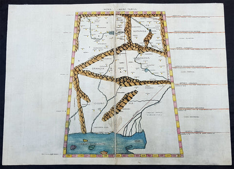
1478 Ptolemy & Buckink Antique Map of Afghanistan, Pakistan, India - Oldest Map on the Market
Antique Map
- Title : Nona Asiae Tabula
- Ref #: 92609
- Size: 22 1/4in x 16 1/2in (565mm x 420mm)
- Date : 1478
- Condition: (A+) Fine Condition
Description:
The first printed book, with maps, was published in Bologna, Italy in 1477. The maps were engraved by Taddeo Crivelli (active 1451 - 1479) after the text of the famous 1st century Alexandrian cartographer Claude Ptolemy. Only 26 editions of this atlas were printed with all remaining editions, today, in institutional hands.
In the following year 1478, the second atlas was printed, again after Ptolemy, in Rome by Konrad Sweynheym & completed by Arnold Buckink. These maps are considered far superior in detail and quality to the 1477 1st edition and are the earliest maps available to the modern day collector.
This map of what is today Pakistan, Afghanistan and parts of India, the 9th in the Asian series of Ptolems 27 maps, was published by Arnold Buckinck in Claudii Ptolemaei Alexandrini philosophi Geographiam Romae after the death of his predecessor Conrad Sweynheym.
Considering this is one of the earliest books ever published the typeface and characteristics of these maps and text are extraordinary. Of the engraved editions of Ptolemys Geographia the maps in the Rome edition are some of the finest and only beaten a 100 years later by Gerard Mercator in his 1578 edition of Geographia.
This large map is in fine condition, on strong sturdy and stable paper the printing is heavy and clear. The colour is original, clear and bright. There is some light discolouration to the paper, along with some light soiling two thirds down the center of the map with some show-through on the verso. Overall in fantastic condition and a unique addition to any collection.
General Definitions:
Paper thickness and quality: - Heavy and stable
Paper color : - off white
Age of map color: - Original
Colors used: - Yellow, green, blue, pink
General color appearance: - Authentic
Paper size: - 22 1/4in x 16 1/2in (565mm x 420mm)
Plate size: - 22 1/4in x 16 1/2in (565mm x 420mm)
Margins: - Min 1/2in (12mm)
Imperfections:
Margins: - Light soiling, age toning, old neutralised tape mark bottom right
Plate area: - Neutralised tape mark bottom right
Verso: - Soiling, age toning, old neutralised tape mark
Background:
The first published edition of Ptolemys Geographia with maps, engraved by Taddeo Crivelli, in Bologna, 1477. Unusually, this edition contained 26 maps, with one of the Asia maps divided up among three neighbouring sheets. With the exception of Palestine, these are the first regional maps of any of these various countries.
Unfortunately for the publishers, this atlas was not a commercial success, and today only twenty-six examples of the atlas are recorded.
One explanation of the failure, is that the publishers do not seem to have been fully mastered the intricacies and problems of engraving, and printing from, copper-plates, an art, which, after all, was very new and experimental. These problems were more successfully addressed by a German printer, Conrad Sweynheym, who was working on an edition of Ptolemy in Rome in the same period. Unfortunately, he did not live to see the volume appear, but his successor, Arnold Buckinck, saw the atlas through the press, in 1478.
The Rome Ptolemy contained 27 maps, with the same geographical coverage as the 1477 Ptolemy. Of the engraved editions of Ptolemys Cosmographia the maps in the Rome edition are the finest fifteenth century examples, and second only to Mercators maps, from his 1578 edition. One explanation for this was the use of individual punches to stamp letters onto the printing plates, rather than engraving them. This allowed much greater uniformity than lettering-engravers were able to achieve, and gives a very pleasing overall effect. The atlas proved popular, and three successive editions (to 1508) followed, although only about forty examples of the first edition are recorded today.
Ptolemy, Claudius 90 A.D.-168 A.D.
Claude Ptolemy was a celebrated astronomer, mathematician, and geographer who lived in Alexandria in the 2nd century AD. Although his thinking influenced contemporary Arab geographers, little was known of his work in the West until manuscripts from Constantinople reached Italy in about 1400. These manuscripts were written in Greek and contained the names of every city, island, mountain and river known to the many travellers interviewed by Ptolemy. In addition, the latitude and longitude of each of the resulting eight thousand locations were also recorded. They were translated into Latin by 1401 and appeared in print by 1475. The earliest Byzantine manuscript maps, drawn by analysing the Ptolemy figures, date from the twelfth century. A number of hand-drawn copies were made in Italy throughout the early fifteenth century to accompany Ptolemys text.
Ptolemy stressed the importance of accurate observations in order to calculate latitude and longitude, and laid down the principals of systematic cartography that remain to this day. Obviously there are many errors in Ptolemys maps, due to the limited extent of basic geographic information at that time and the lack of a method of determining accurate longitudes. Judged by modern standards, the basic shortcoming of the Ptolemy world map is the small area it portrays. The Mediterranean is fairly well depicted, but is greatly exaggerated in length (Longitudinally). The effect of this, combined with Ptolemys disregard for Eratosthenes extremely accurate estimate of the earths circumference (c. 200 B.C.) and the use of a Posidonius much smaller flawed estimate (c.50 B.C.) implied a much shorter distance across that part of the unknown earths surface not drawn on the map. Columbus and his contemporaries based their exploratory ventures on Ptolemys calculations and, like him, had no idea of the vast New World to the west, interposed between Europe and Asia.
Work on the first printed atlas from the text of Ptolemy was started in 1473 and finally published in 1478. A crude copy of this atlas was produced and published by some dissident workers in 1477 in order to be first. However, the plates for the 1478 were done prior to the pirated issue and thus the 1478 atlas holds the title of the first Atlas of the world. There are very few surviving examples of this atlas and individual maps.
Ptolemys Geographia The first published edition of Ptolemys Geographia with maps, engraved by Taddeo Crivelli, was issued in Bologna in 1477. Unusually, this edition contained 26 maps, with one of the Asia maps divided up among three neighbouring sheets. With the exception of Palestine, these are the first regional maps of any of these various countries.
Unfortunately for the undertakers, this atlas seems not to have been a commercial success, and today only twenty-six examples of the atlas are recorded, with all but one in institutional libraries.
One explanation of the failure is that the publishers do not seem to have been fully mastered the intricacies and problems of engraving, and printing from, copper-plates, an art, which, after all, was very new and experimental. These problems were more successfully addressed by a German printer, Conrad Sweynheym, who was working on an edition of Ptolemy in Rome in the same period. Unfortunately, he did not live to see the volume appear, but his successor, Arnold Buckinck, saw the atlas through the press, in 1478.
The Rome Ptolemy contained 27 maps, with the same geographical coverage as the 1477 Ptolemy. Of the engraved editions of Ptolemy Cosmographia the maps in the Rome edition are the finest fifteenth century examples, and second only to Mercators maps, from his 1578 edition. One explanation for this was the use of individual punches to stamp letters onto the printing plates, rather than engraving them. This allowed much greater uniformity than lettering-engravers were able to achieve, and gives a very pleasing overall effect. The atlas proved popular, and three successive editions (to 1508) followed, although only about forty examples of the first edition are recorded today.
Konrad Sweynheim & Arnold Pannartz were two printers of the 15th century.
Pannartz died about 1476, Sweynheym in 1477. Pannartz was, perhaps, a native of Prague, and Sweynheym of Eltville near Mainz. Gottfried Zedler believed (Gutenberg-Forschungen, 1901) that Sweynheym worked at Eltville with Gutenberg in 1461-1464. Whether Pannartz had been connected with Sweynheym in Germany is not known. It is certain that the two brought Gutenbergs invention to Italy.
The Benedictine abbey of Subiaco was the cradle of Italian printing. Probably Cardinal Giovanni of Turrecremata, who was Abbot in commendam of Subiaco, summoned the two printers there. They came in 1464. The first book that they printed at Subiaco was a Donatus; it has not, however, been preserved. The first book printed in Italy that is extant was a Cicero, De oratore (now in the Buchgewerbehaus at Leipzig), issued in September, 1465. It was followed by Lactantius, De divinis institutionibus, in October, 1465, and Augustines De civitate Dei (1467). These four impressions from Subiaco are of particular importance, because they abandon the Blackletter of the early German books. In Italy, Roman characters were demanded. Pannartz and Sweynheym, however, did not produce a pure but only a half Roman type with Blackletter-like characteristics.
In 1467, the two printers left Subiaco and settled at Rome, where the brothers Pietro and Francesco Massimo placed a house at their disposal. The same year, they published an edition of Ciceros letters that gave its name to the cicero, the Continental equivalent of the pica. Their proof and manuscript reader was Giovan de Bussi, since 1469 Bishop of Aleria in Corsica.
The works they printed are given in two lists of their publications, issued in 1470 and 1472. Up to 1472, they had published twenty-eight theological and classical volumes, namely, the Bible, Lactantius, Cyprian, Augustine, Jerome, Leo the Great, Thomas Aquinas, Cicero, Apuleius, Gellius, Virgil, Livy, Strabo, Pliny, Quintilian, Suetonius, Ovid, etc., in editions varying from 275 to 300 copies each, in all 12,475 volumes. But the printers shared the fate of their master, Gutenberg; they could not sell their books, and fell into want.
In 1472, they applied to Pope Sixtus IV for Church benefices. From this we know that both were ecclesiastics: Pannartz of Cologne and Sweynheym of Mainz. The pope had a reversion drawn up for them, a proof of his great interest in printing. In 1474, Sweynheym was made a canon at St. Victor at Mainz. It is not known whether Pannartz also obtained benefice. Perhaps the pope also aided them; at any rate, they printed eighteen more works in 1472 and 1473. After this they separated. Pannartz printed by himself thirteen further volumes. Sweynheym took up engraving on metal and executed the fine maps for the Cosmography of Ptolemy, the first work of this kind, but died before he had finished his task.
Please note all items auctioned are genuine, we do not sell reproductions. A Certificate of Authenticity (COA) can be issued on request.