
Claude Delisle (1644-1720)
Profile :
Claude Delisle, also known as Guillaume Delisle, was one of the most important and influential cartographers of the 18th century. His innovative approach to cartography, which was grounded in the latest scientific knowledge and measurement techniques, revolutionized the field and set a new standard for accuracy and precision in mapmaking.
Delisle's maps were known for their exceptional accuracy and detail, and they were widely used by governments, scholars, and explorers throughout Europe. He drew upon the latest astronomical and mathematical data to create maps that were more precise and reliable than those that had come before.
One of Delisle's most important contributions to cartography was his development of the "Delisle Method," which involved the use of triangulation to measure distances between points on the earth's surface. This method allowed for more accurate mapping of large areas and was widely adopted by other cartographers.
Delisle's maps were also notable for their use of shaded relief, which helped to convey a sense of three-dimensionality and depth. He was one of the first cartographers to incorporate this technique into his maps, and it became a hallmark of his work.
Delisle produced a number of important maps and atlases during his career, including the Atlas Nouveau, which was considered one of the finest atlases of the 18th century. He also produced maps of many regions of Europe, Africa, and the Americas, including detailed maps of France, Spain, Portugal, and the British Isles.
Delisle's work had a profound impact on the field of cartography, and his legacy as one of the greatest cartographers of all time continues to be felt today. His maps and atlases are highly valued by collectors and scholars, and his contributions to the field of geography and mapmaking have been recognized and celebrated for centuries.
Claude Delisle (4)
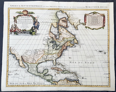
1708 Delisle & Mortier Large 1st edition Antique Map of North America - Landmark Map
- Title : L Amerique Septentrionale dressee sur les Observations de Mrs. De L Academie Royale des Sciences & quelques autres..., par N. Sanson, Amsterdam,
- Size: 23 1/2in x 19in (595mm x 485mm)
- Condition: (A+) Fine Condition
- Date : 1708 (1st ed)
- Ref #: 93008
Description:
This is without doubt one of the most important foundation maps, of North America, published in the early to mid 18th century.
A large 1st edition, original hand coloured copper-plate engraved antique map of North America, by Pierre Mortier, after Guillaume Delisle, that was published in 1708 in Atlas nouveau de dicerses cartes choisies des Meilleurs Geographes comme Sanson, G De Lisle &c....A Amsterdam.....
A rare map with the mistaken dedication to Nicolas Sanson, in the title. This oversight was removed in all other subsequent editions.
General Definitions:
Paper thickness and quality: - Heavy and stableAntonio Zattadelisle
Paper color : - off white
Age of map color: - Original & later
Colors used: - Blue, pink, red, green, yellow
General color appearance: - Authentic
Paper size: - 23 1/2in x 19in (595mm x 485mm)
Plate size: - 23in x 17 3/4in (580mm x 450mm)
Margins: - Min 1/2in (15mm)
Imperfections:
Margins: - None
Plate area: - None
Verso: - None
Background:
There are many reasons why this rare 1st edition foundation map is important. It contains detail of radical changes both to the interior of North America and helps debunk many fundamentally held ideas of the coastlines. Some of these ideas included The Great lakes, California as an island and previously invented ideas of the interior, NW & NE coastlines.
Specifically the shape of the Great Lakes are changed based on information from the great Italian cartographer Vincenzo Coronelli.
The Mississippi valley is well developed with recent French settlement of d\'Iberville at Bilochy and the forts at Bon Secours and St Louis. The map also corrects the error of the western swing of the lower part of the Mississippi River, moving its mouth to essentially its correct position on the Gulf of Mexico.
Delisle has also corrected longitude positions and was the first to revert to a peninsular form for California. He stops his western coast at Cape Mendocin and is the first map to show the Saragossa Sea.
The map also illustrates the routes of explorers such as Cortez, Drake, D\'Olivier, Gaeten and Mendana, and indicates the locates of a number of Indian tribes, including the Apaches.
As this is a French map we see many of the French strong points in the NE such as Tadousac, Quebec, Fort Sorel, Montreal & Fort Frontenac included. The English settlements are confined to the east of the Alleghenies, with Fort and River Kinibeki as the border between New England and Arcadia.
Such was the improvement of this map, and the sterling reputation of Delisle, that within a few years other publishers issued their own copies of the map, which continued to appear until the 1780s. The importance of this map cannot be overstated in the progression of American cartography. (Ref: M&B; Tooley)
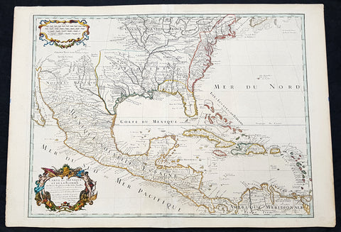
1708 Guillaume Delisle Large Antique Map of North America - 4th State, rare
- Title : Carte Du Mexique et de la Floride des Terres Angloises et des Isles Antilles du Cours et des Environs de la Riviere Mississipi . . .Chez L Auteur sue le Quaide de l Horlage Privilege du Roy po. 20 ana 1703
- Date : 1708
- Condition: (A+) Fine Condition
- Ref: 93525
- Size: 29 1/4in x 20 1/2in (750mm x 520mm)
Description:
In the world of early 18th century American cartography, no one published as many landmark maps of North America as the French family firm of Delisle. This large original copper-plate engraved scarce map of North America became one of the most copied map of the next 100 years by the likes of Homann, Seutter, Lotter, Sanson and many others. Engraved by Charles Simoneau, this map is the 4th state of seven (identified with the date 1703 in the cartouche with Delisles address in Paris erased) was published by Guillaume Delisle in the <i>Atlas Nouveau.</i>
The 7 states outlined by Tooley are:
- State 1 (1703): De LIsles first address on Rue Des Canettes.
- State 2 (1703): address changed to Quai de lHorloge Couronne de Diamans and the imprint of Renard.
- State 3 (1708): Couronne de Diamans is erased and <i>se trouve a Amsterdam chez L. Renard Libraire prez de la Bourse</i> is added
- State 4 (1708): <i>A Paris Chez L Auteur sur le Quai de l Horloge</i> is added and <i>Couronne de Diamans and Renards</i> imprint are removed and the engravers name (Simoneau) appears below the cartouche.
- State 5 (1722): <i>A Amsterdam Chez Jean Covens & Corneille Mortier avec Privilege 1722</i> Re-engraved and published by Covens & Mortier in Atlas Nouveau
- State 6 (1745): Philippe Buache imprint added below neatline at right.
- State 7 (1783): Title altered to Carte du Mexique et des Etas Unis dAmerique, Partie Meridionale, issued by Dezauche, showing US States and boundaries.
General Definitions:
Paper thickness and quality: - Heavy and stable
Paper color : - off white
Age of map color: - Original & later
Colors used: - Yellow, green, blue, pink
General color appearance: - Authentic
Paper size: - 29 1/4in x 20 1/2in (750mm x 520mm)
Plate size: - 26in x 19 1/2in (660mm x 495mm)
Margins: - Min 1in (20mm)
Imperfections:
Margins: - None
Plate area: - None
Verso: - None
Background:
This map, which is one of the three great maps of regional North America conceived by Delisle during the first quarter of the eighteenth century, identifies the colonial affiliations that defined the destiny of North America by the end of the century. As is often the case, the British North American Colonies are shown hemmed in by the Appalachians and crowding the Atlantic coast. The status of present-day South Carolina is dubious, the coloring implying that it may belong to Spain. To the north and west of New England, Canada confines the British colonies even further. In the Southwest, French Floride extends to the Rio Grande and south to present-day Brownsville. The northern boundary of Floride is indicated, except that it abuts Canada, thereby giving France possession of the entire middle part of the continent. Various remarks and locations for Native American tribes are shown, indicating, for example, the locations of the Apache Vaqueros, the Apache Navaio, and the Tiguas. In the French possessions many tribes and their villages are indicated, for example, the famous Cenis in Texas, the Apalache in Georgia and Florida, and the Kicapou near the Great Lakes (their original location before they were pushed all the way to Mexico). Delisles debts to Ibervilles explorations are frequently shown on this map.
The map was compiled from the reports brought back to France from the survivors of the La Salle expedition into the interior of North America and from the information derived from the explorations of Bienville and dIberville. In the year preceding the publication of the map, De LIsle utilized his position with the King of France to gain access to the best available information from the new world. During this time period he assiduously compiled the geographical data from the reports of the French Jesuit Missionaries and Explorers in North America, along with Spanish manuscript maps (often copied by the Missionaries while they were acting in the service of the Spanish as spiritual guides and gaining their confidence).
The result of this work were a series of landmark maps of the North America, including his map of North America ( LAmerique Septentrionale, 1700), Canada and the Great Lakes ( Carte du Canada ou de la Nouvelle France 1703), and the Mississippi Valley & Gulf Coast ( Carte de la Louisiane et du Cours du Mississipi 1708).
The map has been a towering landmark along the path of Western cartographic development. De LIsles map also includes greater accuracy in the Great Lakes region and in its depiction of English settlements along the East Coast. Excellent detail of the Indian villages in East Texas, based upon the reports of dIberville and the Spanish missionaries. The best depiction of the Southwest to date, with early trails & Indian tribes. Cumming described the map as profoundly influential.
Many have suggested that Claude Delisle, father of Guillaume, was the one who conducted the research on the maps, whereas Guillaume was the one who actually drew the maps and engraved the plates. Obviously the maps were a collaborative effort of the Delisle firm.
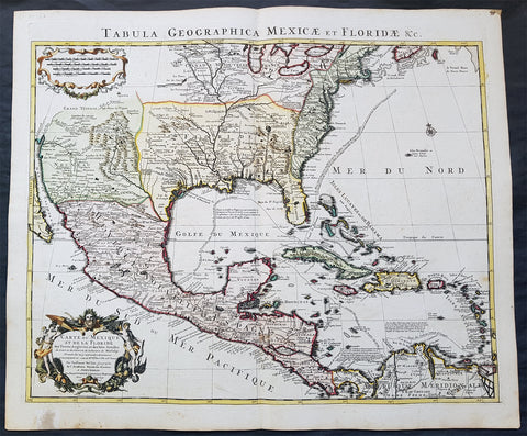
1722 G. Delisle and Covens & Mortier Antique Map of North America - 5th State
- Title : Carte Du Mexique et de la Floride des Terres Angloises et des Isles Antilles du Cours...1722
- Date : 1722
- Condition: (A+) Fine Condition
- Ref: 70814
- Size: 25 1/2in x 21 1/2in (650mm x 545mm)
Description:
In the world of early 18th century American cartography, no one published as many landmark maps of North America as the French family firm of Delisle. This large original copper-plate engraved scarce map of North America became one of the most copied map of the next 100 years by the likes of Homann, Seutter, Lotter, Sanson and many others.
Re-engraved and published by Covens & Mortier in Amsterdam, this map is the 5th state of seven, published in the Atlas Nouveau.
The 7 states outlined by Tooley are:
- State 1 (1703): De LIsles first address on Rue Des Canettes.
- State 2 (1703): address changed to Quai de lHorloge Couronne de Diamans and the imprint of Renard.
- State 3 (1708): Couronne de Diamans is erased and se trouve a Amsterdam chez L. Renard Libraire prez de la Bourse is added
- State 4 (1708): A Paris Chez L Auteur sur le Quai de l Horloge is added and Couronne de Diamans and Renards imprint are removed and the engravers name (Simoneau) appears below the cartouche.
- State 5 (1722): A Amsterdam Chez Jean Covens & Corneille Mortier avec Privilege 1722 Re-engraved and published by Covens & Mortier in Atlas Nouveau
- State 6 (1745): Philippe Buache imprint added below neatline at right.
- State 7 (1783): Title altered to Carte du Mexique et des Etas Unis d Amerique, Partie Meridionale, issued by Dezauche, showing US States and boundaries.
Condition Report
Paper thickness and quality: - Very heavy and stable
Paper colour: - Off white
Age of map colour: - Original & later
Colours used: - Yellow, green, pink, blue
General colour appearance: - Fresh
Paper size: - 25 1/2in x 21 1/2in (650mm x 545mm)
Plate size: - 24in x 19 1/2in (610mm x 495mm)
Margins: - Min 1/2in (10mm)
Imperfections:
Margins: - Light age toning in bottom margin
Plate area: - None
Verso: - None
Background:
The importance of this landmark map by Guillaume Delisle cannot be overstated. It was the first map to accurately depict the course and mouth of the Mississippi River. Much of the map was drawn from reports brought back to France from the survivor's of the La Salle expedition into the interior of North America and from information derived from the explorations of Bienville and d'Iberville. In the year preceding the publication of the map, Delisle utilised his position with the King of France to gain access to the best available information from the new world.
During this time, he compiled the geographical data from the reports of the French Jesuit Missionaries and explorer's in North America, along with Spanish manuscript maps (often copied by the Missionaries while they were acting in the service of the Spanish as spiritual guides and gaining their confidence). The result of this work were a series of 4 landmark maps of America, including his map of North America (L'Amerique Septentrionale, 1700), Canada and the Great Lakes (Carte du Canada ou de la Nouvelle France 1703) and the Mississippi Valley & Gulf Coast (Carte de la Louisiane et du Cours du Mississipi 1708) and of course this map.
Carl Wheat called this map a "towering landmark along the path of Western cartographic development." De L'Isle's map also inlcuded greater accuracy in the Great Lakes region and in its depiction of English settlements along the East Coast. Excellent detail of the Indian villages in East Texas, based upon the reports of Iberville and the Spanish missionaries. The best depiction of the Southwest to date, with early trails & Indian tribes. Cumming described the map as "profoundly influential. This is a beautifully engraved and hand coloured map by one of the finest French cartographers of the 18th century. (Ref: Cummings; M&B; Tooley)

1730 Delisle and Covens & Mortier Foundation Antique Map of North America
- Title : L Amerique Septentrionale dressee sur les Observations de Mrs. De L Academie Royale des Sciences & quelques autres & sur les Memoires les plus recens Par G De L Isle A. Amsterdam Chez I Covens & C Mortier Avec Privilege.
- Ref #: 93501-1
- Size: 25 1/2in x 21 1/2in (650mm x 540mm)
- Date : 1700 (1730)
- Condition: (A+) Fine Condition
Description:
This is without doubt one of the most important foundation maps, of North America, published in the early to mid 18th century. This large original hand coloured copper-plate engraved antique map by Johannes Covens & Pierre Mortier, after Guillaume Delisle, that was published in 1730 in Atlas nouveau de dicerses cartes choisies des Meilleurs Geographes comme Sanson, G De Lisle &c....A Amsterdam.....
The first edition of this map was mistakenly dedicated to Nicolas Sanson, in the title. This oversight was corrected to Delisle in this 1730 edition.
This map is beautiful with original borders beautiful hand colouring on heavy stable paper.
Covens & Mortier (fl 1721-1866) was an eighteenth century cartographic publishing house. The company was founded by Johannes Covens (1697-1774) and Cornelis Mortier (1699-1783) and was located in Vijgendam in Amsterdam .
The collaboration between the two men began after the death of Pieter Mortier (1661-1711), son of a French political refugee. In 1690, Mortier obtained the privilege of distributing maps and atlases from French publishers, in the Netherlands . His widow continued business until his death in 1719 . His son Cornelis took over the business, under the name of his father.
In November 1721 Cornelis Mortier founded a company with Johannes Covens I. He was married in the same year to Corneliss sister. Thus the company of Covens & Mortier was born.
General Definitions:
Paper thickness and quality: - Heavy and stable
Paper color : - off white
Age of map color: - Original & later
Colors used: - Yellow, green, blue, pink
General color appearance: - Authentic
Paper size: - 25 1/2in x 21 1/2in (650mm x 540mm)
Plate size: - 23in x 19in (585mm x 490mm)
Margins: - Min 1in (25mm)
Imperfections:
Margins: - None
Plate area: - None
Verso: - None
Background:
There are many reasons why this rare 1st edition foundation map is important. It contains detail of radical changes both to the interior of North America and helps debunk many fundamentally held ideas of the coastlines. Some of these ideas included The Great lakes, California as an island and previously invented ideas of the interior, NW & NE coastlines.
Specifically the shape of the Great Lakes are changed based on information from the great Italian cartographer Vincenzo Coronelli.
The Mississippi valley is well developed with recent French settlement of d\\\'Iberville at Bilochy and the forts at Bon Secours and St Louis. The map also corrects the error of the western swing of the lower part of the Mississippi River, moving its mouth to essentially its correct position on the Gulf of Mexico.
Delisle has also corrected longitude positions and was the first to revert to a peninsular form for California. He stops his western coast at Cape Mendocin and is the first map to show the Saragossa Sea.
The map also illustrates the routes of explorers such as Cortez, Drake, D\\\'Olivier, Gaeten and Mendana, and indicates the locates of a number of Indian tribes, including the Apaches.
As this is a French map we see many of the French strong points in the NE such as Tadousac, Quebec, Fort Sorel, Montreal & Fort Frontenac included. The English settlements are confined to the east of the Alleghenies, with Fort and River Kinibeki as the border between New England and Arcadia.
Such was the improvement of this map, and the sterling reputation of Delisle, that within a few years other publishers issued their own copies of the map, which continued to appear until the 1780s. The importance of this map cannot be overstated in the progression of American cartography. (Ref: M&B; Tooley)