
Claes Jansz Visscher (1587-1652)
Profile :
Claes Jansz Visscher was a prominent Dutch engraver, cartographer, and publisher of the Golden Age of Dutch cartography and printmaking. He was born in Amsterdam in 1587 into a family of engravers and publishers. He learned his craft under his father, Jan Claesz Visscher, and went on to establish his own successful publishing business in Amsterdam.
Visscher is particularly well-known for his contributions to the field of cartography. He produced a number of maps of the Netherlands and other European countries that were characterized by their accuracy and attention to detail. His maps were highly regarded during his time and are still considered some of the finest examples of Dutch cartography.
Visscher was also a skilled engraver, and he produced a large number of prints, including portraits, landscapes, and religious scenes. He was particularly known for his use of intricate, detailed engraving techniques that allowed him to capture the subtle nuances of light and shadow.
Throughout his career, Visscher was commissioned by many leading patrons and collectors, including the Prince of Orange and the Dutch East India Company. His work was highly valued for its technical skill, attention to detail, and beauty, and it continues to be admired by art lovers and collectors today.
Visscher's legacy as a leading figure in Dutch cartography and printmaking can still be seen today. His maps and prints are highly collectible and sought after by art lovers and collectors around the world. His influence on the field of cartography and printmaking continues to be felt, and he is widely regarded as one of the most important figures in the Golden Age of Dutch art and culture.
Claes Jansz Visscher (10)
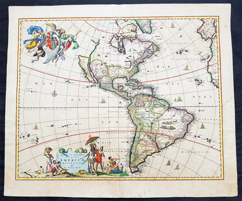
1658 Visscher Large Antique Map of America
- Title : Novissima et Accuratissima Totius Americae Descriptio per N. Visscher
- Ref #: 50683
- Size: 24in x 20 1/4in (610mm x 515mm)
- Date : 1658
- Condition: (A) Very Good Condition
Description:
This large rare beautifully hand coloured original antique 1st edition map of America was published by Nicholas Visscher in ca 1658.
This is an important map, derived from Blaeu's earlier wall map, that would prove influential to many future maps of the western hemisphere, with similar maps issued by De Wit, Danckerts, Allard, and Ottens to the end of the 17th century.
Background:
Various dates have been attributed to this map from 1658 to 1680. The earliest date derives from its presence in the third volume of Jan Jansson's Novus Atlas dated 1658. However, it is not present in all examples and other maps have borne dates as late as 1680. The heirs of Jan Jansson who died in 1664, appear to have issued the volumes with old title pages on a continuous basis.
Although the map did not provide much in the way of cartographic advances after Blaeu, it had a large influence on future cartographers drawing upon either its geography or the distinctive cartouches. One of the most recognisable features is the large open lake in the place of the western Great Lakes. The single lake to its east most probably represents that of Ontario, but is named Lac Contenant. This like much of the map is derived from Joan Blaeu's wall map of the world, 1648. The use of Real de Nueva Mogulcorrectly placed on the east bank of the Rio del Norte is taken directly from Blaeu. One are where Visscher breaks from this is his depiction of the west coast. He uses an older model, that of Briggs, 1625 although with a broader north coast to California as an Island, a feature that was not found in any of Viscchers earlier works. He continues the mainland coastline north-north -east towards the Strait of Anian, which separates it from ANIAN.
The title is decorated with a scene showing the panning of gold or silver, with a native standing by under an umbrella. The cartouche top left bears a dedication to Cornelis Witsen, mayor of Amsterdam who financed many trips to the New World and depicts three angels helping a native Indian to heaven while the devil is fading away. (Burden; M&B; Tooley)
General Description:
Paper thickness and quality: - Heavy and stable
Paper color: - off white
Age of map color: - Original
Colors used: - Red, yellow, green, blue
General color appearance: - Authentic
Paper size: - 24in x 20 1/4in (610mm x 515mm)
Plate size: - 21 1/2in x 17 1/4in (545mm x 440mm)
Margins: - Min 1in (25mm)
Imperfections:
Margins: - Uniform age toning
Plate area: - Uniform age toning, center-fold re-joined, no loss
Verso: - Uniform age toning, light spotting
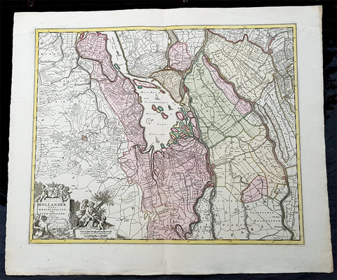
1670 Nicolas Visscher Large Antique Map of South Holland Dordrecht, Gouda, Breda
- Title : Hollandiae Pars Merionalior Vulgo Zuyd-Holland Auctore Nic. Visscher
- Ref #: 93481
- Size: 26 1/2in x 21in (675mm x 515mm)
- Date : 1670
- Condition: (A+) Fine Condition
Description:
This original large beautifully hand coloured copper plate engraved antique map of South Holland, from the city of Gouda in the North to Breda in the South and centering on the city of Dordrecht, was published by Nicolas Visscher in 1670.
General Definitions:
Paper thickness and quality: - Heavy and stable
Paper color : - off white
Age of map color: - Original
Colors used: - Green, yellow, brown, pink
General color appearance: - Authentic
Paper size: - 26 1/2in x 21in (675mm x 515mm)
Plate size: - 22 1/2in x 18in (565mm x 460mm)
Margins: - Min 1in (25mm)
Imperfections:
Margins: - None
Plate area: - None
Verso: - None
Background:
The first city in South Holland to receive city rights was Dordrecht, which did so in 1220. The city retained a dominant position in the area until it was struck by a series of floods in the late 14th century. The same century also saw a series of civil wars, the Hook and Cod wars, concerning the succession of count William IV. Both his daughter Jacqueline and his brother John, the latter supported by Philip the Good, Duke of Burgundy, claimed the throne. The conflict ended in 1490, with John victorious.
Overall, the area of South Holland remained largely agrarian throughout the late Middle Ages. This changed around 1500, when Holland became Europes most urbanised area. During the Eighty Years War, the area of South Holland was the scene of the Capture of Brielle, the Siege of Leiden and the assassination of William the Silent.
The United Netherlands declared their independence in 1581, and Holland quickly emerged as the countrys dominant province, with important trading cities such as Leiden, Delft, Gouda and Dordrecht. In 1575, the Netherlands first university was founded in Leiden by William the Silent. The Hague, which had originated around the castle of the counts of Holland, became its new political centre. Both the States of Holland and the States General seated in the Binnenhof. The Dutch Golden Age blossomed in the 17th century. The south of Holland, back then often referred to as the Zuiderkwartier (literally South Quarter), was the birthplace and residence of many scientists such as Antoni van Leeuwenhoek and Christiaan Huygens, philosophers such as Baruch Spinoza and Pierre Bayle, as well as painters such as Johannes Vermeer, Rembrandt van Rijn and Jan Steen.
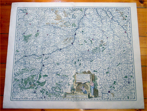
1670 Visscher Large Antique Map of The Liege Region of Belgium - Maastricht
- Title : Leodiensis Episcopatus...Nicolaum Visscher
- Ref #: 60013
- Size: 25in x 21in (635mm x 535mm)
- Date : 1670
- Condition: (A+) Fine Condition
Description:
This large beautifully hand coloured original antique map of Liege Region of Belgium - centering on the Meusa River and the cities of Liege, Maastricht, Namur & Tienen was published by Nicholas Visscher in 1670. (M&B; Tooley)
General Description:
Paper thickness and quality: - Heavy and stable
Paper color: - off white
Age of map color: - Original
Colors used: - Red, yellow, green, blue
General color appearance: - Authentic
Paper size: - 25in x 21in (635mm x 535mm)
Plate size: - 22 1/2in x 18 1/2in (570mm x 470mm)
Margins: - Min 1in (25mm)
Imperfections:
Margins: - None
Plate area: - None
Verso: - None
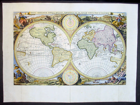
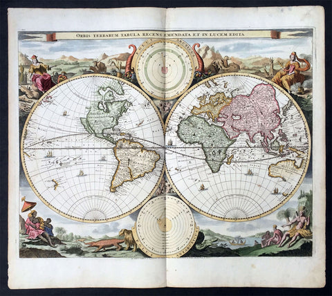
1677 Nicolas Visscher Antique Twin Hemisphere World Map
- Title : Orbis Terrarum Tabula Recens Emendata Et In Lucem Edita Per N. Visscher
- Date : 1677
- Size: 22in x 16in (560mm x 410mm)
- Condition: (A+) Fine Condition
- Ref: 30005
This beautiful, original map is the second state of the second world map prepared by Nicolas Visscher in 1677 for insertion in a Dutch Bible. The first state of this second world map was published in 1663.
General Condition:
Paper thickness and quality: - Heavy & sturdy
Paper color: - off white
Age of map color: - Later
Colors used: - Blue, yellow, green, red, pink
General color appearance: - Authentic
Paper size: - 22in x 16in (560mm x 410mm)
Plate size: - 18 3/4in x 12 1/4in (475mm x 310mm)
Margins: - Min 1in (25mm)
Imperfections:
Margins: - None
Plate area: - Left & right folds as issued, small professional repair along centerfold
Verso: - None
Background: A number of bibles published in the Netherlands contain world maps, those from 1657 onwards contained this map by Visscher. The maps tend to be conservative in form, with certain areas such as California (as a peninsular) being represented more correctly than current theories at the time. On Visschers map parts of Australia and Van Diemens land are marked, but not the north coast of Australia discovered by Tasman's second voyage in 1644.
In the corners the four continents are shown in allegorical form with examples of their animal life and inhabitants. Two circular diagrams depict the heavens.
There were later edition s of the Ravesteyn Bible in at least 1660, 1662, 1667 and 1670. Editions prior to 1657 did not contain maps, although Nicolas Visscher's farther Claes Visscher and another engraver from Amsterdam, Jacob Savry, prepared regional biblical maps in the 1640's. Maps were often added to bibles at a later date. (Ref: Shirley; Tooley)
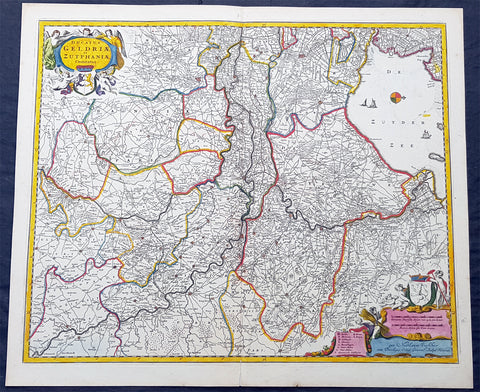
1690 N. Visscher Large Antique Map Northern Holland Guelders & Zutphen Amsterdam
- Title : Ducatus Geldriae et Zutphaniae Comitatus...per Nicolaum Visscher
- Ref #: 93482
- Size: 24in x 20 1/2in (610mm x 520mm)
- Date : 1690
- Condition: (A+) Fine Condition
Description:
This large rare hand coloured original antique map of the Duchy of Guelders and the County of Zutphen was published by Nicholas Visscher II in the 1690 edition of Atlas minor sive totius orbis terrarum contracta delinea ex conatibus Nico. Visscher.
A rare and decorative map of Geldern oriented to the west, covering an area from Amsterdam to the west to Vreden in the east and from Montfoort in the south to Campden in the north.
General Definitions:
Paper thickness and quality: - Heavy and stable
Paper color : - off white
Age of map color: - Original
Colors used: - Yellow, green, blue, pink
General color appearance: - Authentic
Paper size: - 24in x 20 1/2in (610mm x 520mm)
Plate size: - 22 1/2in x 18 1/2in (565mm x 470mm)
Margins: - Min 1/2in (12mm)
Imperfections:
Margins: - None
Plate area: - None
Verso: - None
Background:
Guelders or Gueldres is a historical county, later duchy of the Holy Roman Empire, located in the Low Countries.
The County of Zutphen, located in modern-day Gelderland, a province of the Netherlands, was formed in the eleventh century as a fief of the Bishop of Utrecht. It was ruled by the Counts of Zutphen between 1018 and 1182, and then formed a personal union with Guelders. Later, it became one of the 4 quarters of Guelders. The name Graafschap (county) is still used for the Achterhoek, the region east of Zutphen, and for the football club De Graafschap from this region.
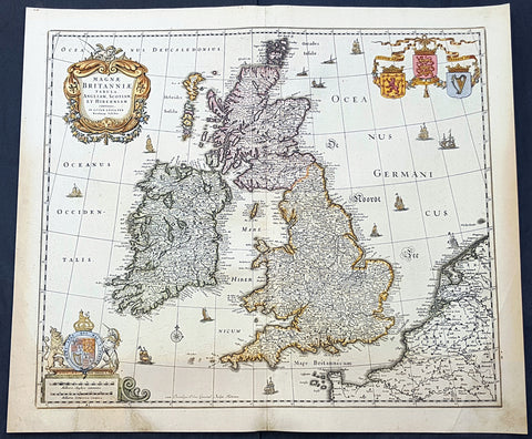
1690 Nicolas Visscher Antique Map of Great Britain & Ireland
- Title : Magnae Britanniae Tabula Angliam, Scotiam, et Hiberniam Continens in Lucem Edita Fer Nicolaum Visscher
- Size: 23in x 19 1/2in (585mm x 490mm)
- Condition: (A) Very Good Condition
- Date : 1690
- Ref #: 93002
Description:
This large original hand coloured copper-plate engraved antique map of Great Britain & Ireland was published by Nicholas Visscher II in 1690.
General Definitions:
Paper thickness and quality: - Heavy and stable
Paper color : - off white
Age of map color: - Original
Colors used: - Yellow, green, blue, pink
General color appearance: - Authentic
Paper size: - 23in x 19 1/2in (585mm x 490mm)
Plate size: - 21in x 18 1/2in (535mm x 485mm)
Margins: - Min 1/2in (12mm)
Imperfections:
Margins: - Small bottom left section of margin into scale restored
Plate area: - Light age toning
Verso: - Age toning
Background:
In 1558 Queen Elizabeth came to the throne in the midst of a fast changing world. In 1563 a nineteen sheet map, copies of which survive only in manuscript form, was completed by Laurence Nowell, and no doubt, the issue of Mercator\'s large-scale map of the British Isles in 1564 had an important influence on the thought of the period. A few years later a national survey was commissioned privately, although probably at the instigation of Lord Burghley, the Lord Treasurer, but subsequently was completed with royal encouragement. The outcome was Christopher Saxton\'s Atlas of EngIand and Wales, started about 1570 and published in 1579 - the first printed set of county maps and the first countrywide atlas on such a splendid scale produced anywhere. A Welsh antiquarian, Humphrey Lhuyd completed a set of surveys that were even more successful than Saxton in which he had produced fine manuscript maps of England and Wales which were used by Ortelius in editions of his Atlas from 1573 onwards.
The earliest maps of the 17th century, attributed to William Smith of the College of Heralds, covered only twelve counties based on Saxton/Norden and were presumably intended to be part of a complete new atlas. They were printed in the Low Countries in 1602-3 and were soon followed by maps for the Latin edition of Camden\'s Britannia dated 1607. In 1610-11 the first edition of John Speed\'s famous county Atlas The Theatre of the Empire of Great Britaine was published and immediately replaced Saxton\'s in popular appeal. Although Speed assembled much of his material from the earlier works of Saxton, Norden and others, a considerable part of the up-to-date information, especially relating to the inset town plans depicted on his maps, was obtained first hand. The maps undoubtedly owed much of their popularity to the splendid engravings of high quality made in the workshops in Amsterdam of Jodocus Hondius to whom Speed sent his manuscripts, the plates subsequently being returned to London for printing.
In 1645, Volume IV of the famous Blaeu World Atlas covering the counties of England and Wales was published in Amsterdam. These maps have always been esteemed as superb examples of engraving and design, the calligraphy being particularly splendid, but nevertheless they were nearly all based on Saxton and Speed and added little to geographical knowledge.
Not until the latter part of the century do we find an English map maker of originality with the capacity to put new ideas into practice. John Ogilby, one of the more colourful figures associated with cartography, started life as a dancing master and finished as King\'s Cosmographer and Geographic Printer. After publishing a small number of county maps, somewhat on the lines of John Norden he issued in 1675 the Britannia, the first practical series of detailed maps of the post roads of England and Wales on a standard scale of 1,760 yards to the mile. Up to the end of the century and beyond, reprints and revisions of Saxton\'s and Speed\'s atlases continued to appear and the only other noteworthy county maps were Richard Blome\'s Britannia (1673), John Overton\'s Atlas (c. 1670) and Robert Morden\'s maps for an English translation of Camden\'s Britannia published in 1695.
Another noted cartographer of the day was Captain Greenvile Collins, and of his work in surveying the coasts of Great Britain culminating in the issue in 1693 of the Great Britain\'s Coasting Pilot. Apart from these charts, English cartographers published during the century a number of world atlases. Speed was the first Englishman to produce a world atlas with the issue in 1627 of his A Prospect of the Most Famous Parts of the World. Other atlases appeared later in the century by Peter Heylin, John Seller, William Berry, Moses Pitt and Richard Blome, whilst Ogilby found time to issue maps of Africa, America and Asia. Far more important, from the purely scientific point of view, was the work of Edmund Halley, Astronomer Royal, who compiled and issued meteorological and magnetic charts in 1688 and 1701 respectively.
At the beginning of the eighteenth century the Dutch map trade was finally in decline, the French in the ascendant and the English to a great extent still dominated by Saxton and Speed except, as we have shown, in the spheres of sea charts and road maps. There were atlases by John Senex, the Bowles family, Emanuel and Thomas Bowen, Thomas Badeslade and the unique bird\'s-eye perspective views of the counties, The British Monarchy by George Bickham. In 1750-60 Bowen and Kitchin\'s The Large English Atlas containing maps on a rather larger scale than hitherto was published.
In 1759 the Society for the encouragement of Arts, Manufactures and Commerce offered an award of £100 for the best original surveys on this scale and by the end of the century about thirty counties had been re-surveyed. These maps, many of which formed, in later years, the basis for the first issues of county maps by the Ordnance Survey Office were not only decorative but a tremendous improvement geographically on earlier local maps. As a consequence, the skills and expertise of the new-style cartographers soon enabled them to cover the world as well as the domestic market. Thomas Jefferys was such a man; he was responsible for a number of the new 1 in. to 1 mile county surveys and he issued an edition of Saxton\'s much battered 200-year-old plates of the county maps, but he is better known for many fine maps of North America and the West Indies. His work was continued on the same lines by William Faden, trading as Faden and Jefferys. Other publishers such as Sayer and Bennett and their successors Laurie and Whittle published a prodigious range of maps, charts and atlases in the second half of the century. A major influence at this time was John Cary who, apart from organizing the first re-survey of post roads since Ogilby and subsequently printing the noted Travellers\' Companion, was a prolific publisher of atlases and maps of every kind of all parts of the world. After starting work with Cary, and taking part in the new road survey, Aaron Arrowsmith set up in his own business and went on to issue splendid large-scale maps of many parts of the world. Both Cary\'s and Arrowsmith\'s plates were used by other publishers until far into the next century and, in turn, their work was taken up and developed by James Wyld (Elder and Younger) and Tallis and Co.
Later into the 19th century some of the better known cartographers and publishers were by Henry Teesdale (1829-30), Christopher and John Greenwood, surveyors, Thomas Moule, a writer on heraldry and antiques (1830-36) and John Walker (1837) but by about the middle of the century few small-scale publishers survived and their business passed into the hands of large commercial concerns such as Bartholomews of Edinburgh and Philips of London who continue to this day. (Ref: Shirley; Tooley; M&B)
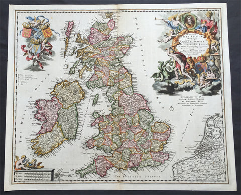
1690 Nicolas Visscher Large Old, Antique Map of Great Britain & Ireland
- Title : Magnae Britanniae Tabula...Angliae, Scotiae, Ac Hiberniae Regna...Per Nicol. Visscher...Guilielmo III D.G.
- Ref #: 61110
- Size: 24in x 20in (610mm x 515mm)
- Date : 1690
- Condition: (A+) Fine Condition
Description: This large rare beautifully hand coloured original antique map of Great Britain & Ireland was published by Nicholas Visscher in 1690
This is a very beautiful map with rich deep colour and heavy engraving on clean and stable paper. It is also an important map, dedicated to William III of Orange (King Billy) who ruled GB & Ireland between 1689 & 1702, a time of great change both in Europe and the New World.
Background: In 1558 Queen Elizabeth came to the throne in the midst of a fast changing world. In 1563 a nineteen sheet map, copies of which survive only in manuscript form, was completed by Laurence Nowell, and no doubt, the issue of Mercator's large-scale map of the British Isles in 1564 had an important influence on the thought of the period. A few years later a national survey was commissioned privately, although probably at the instigation of Lord Burghley, the Lord Treasurer, but subsequently was completed with royal encouragement. The outcome was Christopher Saxton's Atlas of EngIand and Wales, started about 1570 and published in 1579 - the first printed set of county maps and the first countrywide atlas on such a splendid scale produced anywhere. A Welsh antiquarian, Humphrey Lhuyd completed a set of surveys that were even more successful than Saxton in which he had produced fine manuscript maps of England and Wales which were used by Ortelius in editions of his Atlas from 1573 onwards.
The earliest maps of the 17th century, attributed to William Smith of the College of Heralds, covered only twelve counties based on Saxton/Norden and were presumably intended to be part of a complete new atlas. They were printed in the Low Countries in 1602-3 and were soon followed by maps for the Latin edition of Camden's Britannia dated 1607. In 1610-11 the first edition of John Speed's famous county Atlas The Theatre of the Empire of Great Britaine was published and immediately replaced Saxton's in popular appeal. Although Speed assembled much of his material from the earlier works of Saxton, Norden and others, a considerable part of the up-to-date information, especially relating to the inset town plans depicted on his maps, was obtained first hand. The maps undoubtedly owed much of their popularity to the splendid engravings of high quality made in the workshops in Amsterdam of Jodocus Hondius to whom Speed sent his manuscripts, the plates subsequently being returned to London for printing.
In 1645, Volume IV of the famous Blaeu World Atlas covering the counties of England and Wales was published in Amsterdam. These maps have always been esteemed as superb examples of engraving and design, the calligraphy being particularly splendid, but nevertheless they were nearly all based on Saxton and Speed and added little to geographical knowledge.
Not until the latter part of the century do we find an English map maker of originality with the capacity to put new ideas into practice. John Ogilby, one of the more colourful figures associated with cartography, started life as a dancing master and finished as King's Cosmographer and Geographic Printer. After publishing a small number of county maps, somewhat on the lines of John Norden he issued in 1675 the Britannia, the first practical series of detailed maps of the post roads of England and Wales on a standard scale of 1,760 yards to the mile. Up to the end of the century and beyond, reprints and revisions of Saxton's and Speed's atlases continued to appear and the only other noteworthy county maps were Richard Blome's Britannia (1673), John Overton's Atlas (c. 1670) and Robert Morden's maps for an English translation of Camden's Britannia published in 1695.
Another noted cartographer of the day was Captain Greenvile Collins, and of his work in surveying the coasts of Great Britain culminating in the issue in 1693 of the Great Britain's Coasting Pilot. Apart from these charts, English cartographers published during the century a number of world atlases. Speed was the first Englishman to produce a world atlas with the issue in 1627 of his A Prospect of the Most Famous Parts of the World. Other atlases appeared later in the century by Peter Heylin, John Seller, William Berry, Moses Pitt and Richard Blome, whilst Ogilby found time to issue maps of Africa, America and Asia. Far more important, from the purely scientific point of view, was the work of Edmund Halley, Astronomer Royal, who compiled and issued meteorological and magnetic charts in 1688 and 1701 respectively.
At the beginning of the eighteenth century the Dutch map trade was finally in decline, the French in the ascendant and the English to a great extent still dominated by Saxton and Speed except, as we have shown, in the spheres of sea charts and road maps. There were atlases by John Senex, the Bowles family, Emanuel and Thomas Bowen, Thomas Badeslade and the unique bird's-eye perspective views of the counties, The British Monarchy by George Bickham. In 1750-60 Bowen and Kitchin's The Large English Atlas containing maps on a rather larger scale than hitherto was published.
In 1759 the Society for the encouragement of Arts, Manufactures and Commerce offered an award of £100 for the best original surveys on this scale and by the end of the century about thirty counties had been re-surveyed. These maps, many of which formed, in later years, the basis for the first issues of county maps by the Ordnance Survey Office were not only decorative but a tremendous improvement geographically on earlier local maps. As a consequence, the skills and expertise of the new-style cartographers soon enabled them to cover the world as well as the domestic market. Thomas Jefferys was such a man; he was responsible for a number of the new 1 in. to 1 mile county surveys and he issued an edition of Saxton's much battered 200-year-old plates of the county maps, but he is better known for many fine maps of North America and the West Indies. His work was continued on the same lines by William Faden, trading as Faden and Jefferys. Other publishers such as Sayer and Bennett and their successors Laurie and Whittle published a prodigious range of maps, charts and atlases in the second half of the century. A major influence at this time was John Cary who, apart from organizing the first re-survey of post roads since Ogilby and subsequently printing the noted Travellers' Companion, was a prolific publisher of atlases and maps of every kind of all parts of the world. After starting work with Cary, and taking part in the new road survey, Aaron Arrowsmith set up in his own business and went on to issue splendid large-scale maps of many parts of the world. Both Cary's and Arrowsmith's plates were used by other publishers until far into the next century and, in turn, their work was taken up and developed by James Wyld (Elder and Younger) and Tallis and Co.
Later into the 19th century some of the better known cartographers and publishers were by Henry Teesdale (1829-30), Christopher and John Greenwood, surveyors, Thomas Moule, a writer on heraldry and antiques (1830-36) and John Walker (1837) but by about the middle of the century few small-scale publishers survived and their business passed into the hands of large commercial concerns such as Bartholomews of Edinburgh and Philips of London who continue to this day. (Ref: Shirley; Tooley; M&B)
General Description:
Paper thickness and quality: - Heavy and stable
Paper color: - off white
Age of map color: - Original
Colors used: - Red, yellow, green, blue
General color appearance: - Authentic
Paper size: - 24in x 20in (610mm x 515mm)
Plate size: - 23in x 19in (585mm x 460mm)
Margins: - Min 1/2in (12mm)
Imperfections:
Margins: - None
Plate area: - None
Verso: - None
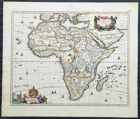
1690 Nicolas Visscher Large Original Antique Map of Africa
- Title : Africae Accurata Tabula ex officina...Nic Visscher
- Date : 1690
- Size: 24 1/2in x 21in (620mm x 535mm)
- Ref #: 61158
- Condition: (A+) Fine Condition
Description:
This large beautifully hand coloured original antique map of Africa was published by Nicholas Visscher in 1690.
This is a fine map with beautiful hand colouring on strong sturdy paper with original margins & a fresh deep impression denoting an early pressing.
General Description:
Paper thickness and quality: - Heavy and stable
Paper color: - off white
Age of map color: - Original
Colors used: - Red, yellow, green, blue
General color appearance: - Authentic
Paper size: - 24 1/2in x 21in (620mm x 535mm)
Plate size: - 21 1/2in x 17 1/4in (540mm x 435mm)
Margins: - Min 1in (25mm)
Imperfections:
Margins: - Top margin repair, no loss
Plate area: - None
Verso: - Old tape top & bottom margin not affecting the image
Background: The first separately printed map of Africa (as with the other known continents) appeared in Munster's Geographia from 1540 onwards and the first atlas devoted to Africa only was published in 1588 in Venice by Livio Sanuto, but the finest individual map of the century was that engraved on 8 sheets by Gastaldi, published in Venice in 1564. Apart from maps in sixteenth-century atlases generally there were also magnificent marine maps of 1596 by Jan van Linschoten (engraved by van Langrens) of the southern half of the continent with highly imaginative and decorative detail in the interior. In the next century there were many attractive maps including those of Mercator/Hondius (1606), Speed (1627), Blaeu (1 630), Visscher (1636), de Wit (c. 1670), all embellished with vignettes of harbours and principal towns and bordered with elaborate and colourful figures of their inhabitants, but the interior remained uncharted with the exception of that part of the continent known as Ethiopia, the name which was applied to a wide area including present-day Abyssinia. Here the legends of Prester John lingered on and, as so often happened in other remote parts of the world, the only certain knowledge of the region was provided by Jesuit missionaries. Among these was Father Geronimo Lobo (1595-1678), whose work A Voyage to Abyssinia was used as the basis for a remarkably accurate map published by a German scholar, Hiob Ludolf in 1683. Despite the formidable problems which faced them, the French cartographers G. Delisle (c. 1700-22), J. B. B. d'Anville (1727-49) and N. Bellin (1754) greatly improved the standards of mapping of the continent, improvements which were usually, although not always, maintained by Homann, Seutter, de Ia Rochette, Bowen, Faden and many others in the later years of the century. (M&B; Tooley)
1714 Visscher & Stoopendaal Large Antique Twin Hemisphere World Map
- Title : Orbis Terrarum Tabula Recens Emendata Et In Lucem Edita
- Ref #: 35492
- Size: 19 ½in x 17in (495mm x 430mm)
- Date : 1714
- Condition: (A) Very Good Condition
Description:
This beautifully engraved hand coloured original twin Hemisphere Antique World map by Nicolas Visscher was engraved by Daniel Stoopendaal and published by Pieter Keur, Rotterdam in 1716.
Background:
Nicolas Visschers Twin Hemisphere World Map is regarded as the forerunner of a number of highly decorative Dutch world maps produced throughout the latter part of the 17th & early 18th centuries.
Essentially based on Blaeu's large world map of 1648, Visscher introduced no substantial new geographical features, however there were minor variations in the still unknown coastline of North America.
The northern part of California (as an Island) has now been flattened and is now called New Albion; still further north a small piece of land or an island "Anian" appears adjacent to a strait leading within striking distance of the west shores of Hudson Bay, a possible early guess at a NW passage.
The distinctive attractiveness of many 17th century Dutch world maps is to be found in their border decorations and this one is no exception. The original artist assisting Visscher, Nicolas Berchem, introduced dramatic classical scenes. Daniel Stoopendaal carried on this tradition by representing each of the 4 know continents in allographical form in the 4 corners Europe, Asia, Africa & The America's. Another small change was the inclusion of astronomical diagrams replacing the north & south polar projections located at the top and bottom of the map.
The Keur family produced a number of fine maps from their presses at Dordrecht and later from Rotterdam in the 17th & 18th centuries. This finely executed twin hemisphere world map is a classic example being first released by Nicolas Visscher and Nicolas Berchem in 1658. (Ref: Shirley; Tooley)
General Description:
Paper thickness and quality: - Heavy and stable
Paper colour: - off white
Age of map colour: - Early colour
Colours used: - Yellow, pink, green, orange
General colour appearance: - Beautifully applied
Plate size: - 19 ½in x 17in (495mm x 430mm)
Plate size: - 18 ½in x 14 ½in (470mm x370mm)
Margins: - Min 1/2in (12mm)
Imperfections:
Margins: - Light age toning in margins
Plate area: - Several small worm holes professionally repaired
Verso: - Light age toning