
Jacques Nicholas Bellin (1703 - 1772)
Profile :
A French hydrographer, geographer, and member of the French intellectual group called the philosophes.
Bellin was born in Paris. He was hydrographer of France's hydrographic office, member of the Académie de Marine and of the Royal Society of London. Over a 50-year career, he produced a large number of maps of particular interest to the Ministère de la Marine. His maps of Canada and of French territories in North America (New France, Acadia, Louisiana) are particularly valuable. He died at Versailles.
In 1721, at age 18, he was appointed hydrographer (chief cartographer) to the French Navy. In August 1741, he became the first Ingénieur de la Marine of the Depot des cartes et plans de la Marine (the French Hydrographical Office) and was named Official Hydrographer of the French King.
During his reign the Depot came out with prodigious amount of charts and maps among which was a large folio format sea-charts of France, the Neptune Francois. He also produced a number of sea-atlases of the world, e.g., the Atlas Maritime and the Hydrographie Francaise. These gained fame, distinction and respect all over Europe and were republished throughout the 18th and even in the succeeding century.
Bellin also came out with smaller format maps such as the 1764 Petit Atlas Maritime (5 vols.) containing 580 finely detailed charts.
Bellin set a very high standard of workmanship and accuracy thus gaining for France a leading role in European cartography and geography. Many of his maps were copied by other mapmakers of Europe
He was one of the Encyclopédistes, a group of 18th century intellectuals in France who compiled the 35-volume Encyclopédie which was edited by Denis Diderot and Jean le Rond d'Alembert. Bellin contributed 994 articles.
The Encyclopédistes, were part of the group called philosophes among whose members were the great minds of the Age of Enlightenment, e.g., Montesquieu, Voltaire, Rousseau, Baron d'Holbach.
Bellin contributed a number of maps to 15-vol. Histoire Generale des Voyages of Antoine François Prévost or simply known l'Abbe Prevost. One of these maps led to a geographical blunder whose impact reverberates to this day. This was the map of the Philippines which Bellin copied from a world-famous chart produced in 1734 by the Spanish missionary to the Philippines, Fr. Pedro Murillo Velarde.
Unlike many other European mapmakers of the time who outright appropriated Murillo's map, Bellin had the intellectual integrity to fully credit Murillo as his source, an open acknowledgement shown in the title cartouche of Bellin's map which came out the same year as the original work by Murillo.
Shown in Bellin's map was an island named "Limasava", a word invented in 1667 by Spanish friar, Fr. Francisco Combés, S.J., to refer to the way station of the Armada de Molucca under the command of the Portuguese captain-general Fernao de Magalhaes during its navigation in Philippine waters. Combés, who had not read a single eyewitness account of the Magellan expedition relied on two sources, the hopelessly garbled Italian translation of the Antonio Pigafetta account by Giovanni Battista Ramusio and the secondhand account by Antonio de Herrera y Tordesillas. Ramusio wrote the fleet anchored in March–April 1521 in Butuan in Mindanao, and from there sailed for Cebu with a brief stopover at "Messana". In the authentic Pigafetta account, the port was an isle named Mazzaua while the stopover isle was named Gatighan. Antonio de Herrera y Tordesillas gave a faithful narration of the Mazzaua anchorage.
Combés disregarded de Herrera's version and adopted Ramusio's. He wrote that Magellan's fleet had anchored at Butuan and from their sailed for Cebu making a stop at a way station he named Limasaua.
Five years earlier than Combés, Fr. Francisco Colín wrote the Armada moored at Butuan from March–April 1521 where Magellan and his men together with the natives celebrated an Easter Sunday mass on 31 March 1521. From Butuan the fleet sailed for Cebu making a brief stop at a way station he called "Dimasaua", an invented word meaning "this is not the Mazagua of Antonio de Herrera where supposedly an Easter Sunday mass was held which I already said happened in Butuan."
This episode was projected in the 1734 map made by Murillo who used Combés name, "Limassava" not "Dimasaua" which map Bellin copied
In 1789, Augustinian Carlo Amoretti, Italian Encyclopedist and librarian of Biblioteca Ambrosiana in Milan, discovered the authentic Italian manuscript of Antonio Pigafetta among the scattered holdings of the library. Here it came out that the port of March–April 1521 was not Butuan but Mazaua. Amoretti, who himself had not read any of five eyewitness reports of the incident including two French versions of Pigafetta's account, asserted in a footnote that Mazaua was probably the isle named Limasava in Bellin's map, thus interchanging the real port of Mazaua with the way station Gatighan.
Largely with the appearance of the eyewitness account of Ginés de Mafra, the only seaman in Magellan's fleet to return to Mazaua, whose testimony reveals a concrete, measurable description of Mazaua, the skein starting from the garbled version of Pigafetta by Ramusio to the mishandling by Combés to Bellin and finally to Amoretti has been unraveled: Pigafetta's Gatighan is Bellin's Limasava.
Published Works:
- Hydrographie française (1753)
- Carte de l'Amérique septentrionale (Map of Northern America) (1755)
- Le petit Atlas François. Recueil de Cartes et Plans des quatre parties du Monde (1758)
- Petit Atlas Maritime (1764)
- Nouvelle méthode pour apprendre la géographie (1769)
Jacques Nicholas Bellin (9)

1744 Bellin & de Maurepas Large Antique Map North America Colonial United States
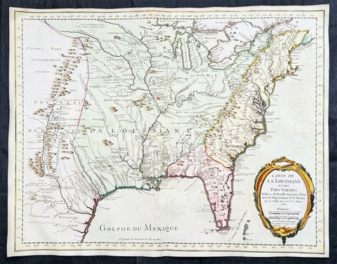
- Title : Carte De La Louisiane Cours Du Mississipi et Pais Voisins...N Bellin 1744
- Date : 1744
- Size: 23in x 16 1/4in (585mm x 415mm)
- Condition: (A) Very Good Condition
- Ref: 27094
Description:
This important, original hand coloured copper plate engraved antique map of North America and the colonial states by Nicolas Bellin in conjunction with Jean-Frédéric Phélypeaux, the Comte de Maurepas, was engraved and published in 1744, dated.
This detailed map depicts the region of Louisiana and the Mississippi River, as well as neighboring territories such as Florida, the Great Lakes, and the Gulf of Mexico. The map is richly decorated with a detailed cartouche featuring a Native American figure, various animals, and a scale bar.
The map is highly detailed and accurate, with the major waterways, coastlines, and settlements clearly marked. The topographical features such as mountains, forests, and swamps are also depicted in great detail. The map includes annotations in French, indicating the locations of various Native American tribes and European settlements.
One interesting feature of the map is the depiction of the river system, with numerous tributaries branching out from the Mississippi River. The map also includes illustrations of the mouth of the Mississippi River and various settlements along its banks.
Overall, Carte De La Louisiane Cours Du Mississipi et Pais Voisins is a beautiful and informative example of 18th-century cartography. Bellin's map reflects the geopolitical tensions of the era, as France and England were competing for control over the region, and it remains a valuable resource for historians and collectors alike.
General Definitions:
Paper thickness and quality: - Heavy and stable
Paper color : - off white
Age of map color: - Original
Colors used: - Yellow, green, blue, pink
General color appearance: - Authentic
Paper size: - 23in x 16 1/4in (585mm x 415mm)
Plate size: - 23in x 16 1/4in (585mm x 415mm)
Margins: - Min 1/2in (12mm)
Imperfections:
Margins: - Right margin extended from border
Plate area: - Folds as issued
Verso: - Folds as issued
Background:
The Comte de Maurepas and Nicolas Bellin were both influential figures in the French Navy during the 18th century, and they worked closely together on several important projects.
Jean-Frédéric Phélypeaux, the Comte de Maurepas, was a French statesman who served as Secretary of State for the Navy under Louis XV. He was a strong supporter of naval exploration and cartography, and he played a key role in promoting the work of cartographers such as Nicolas Bellin.
Nicolas Bellin, as mentioned earlier, was a French cartographer, hydrographer, and engineer who produced numerous maps and atlases that were highly regarded for their accuracy and detail. Bellin worked closely with the Comte de Maurepas on several projects, including the creation of the Neptune François, a collection of maps and nautical charts of the world's oceans.
The Neptune François was a major undertaking that involved the collaboration of numerous cartographers and hydrographers, including Bellin. The project was overseen by the Comte de Maurepas and was intended to provide French sailors with the most up-to-date and accurate information about the world's oceans.
Bellin's contributions to the Neptune François were extensive, and he was responsible for creating numerous maps and charts that covered a wide range of regions, including the Mediterranean, the Caribbean, and North America. His work on the project helped establish him as one of the leading cartographers of his time.
Overall, the Comte de Maurepas and Nicolas Bellin were both instrumental in advancing the field of cartography during the 18th century. Through their collaboration on projects such as the Neptune François, they helped to establish the French Navy as a leading authority on maritime exploration and mapping.
Please note all items auctioned are genuine, we do not sell reproductions. A Certificate of Authenticity (COA) can be issued on request.

1744 Nicolas Bellin Large Important Antique Map of North America, Charlevoix
- Title : Carte De La Louisiane Cours Du Mississipi et Pais Voisions Dediee a M la Comte de Maurepas...Par N Bellin Ingenieur de la Marine, 1744
- Date : 1744
- Condition: (A+) Fine Condition
- Ref: 93108
- Size: 29in x 20in (735mm x 515mm)
Description:
This large original hand coloured copper-plate engraved antique map of North America by Nicolas Bellin, in 1744 - dated - was engraved by Guillaume Dheulland (1700-1770) & published in Pierre Francois Xavier Charlevoix book on Canada & North America Histoire et Description Generale de la Nouvelle France avec Le Journal Historique d\'un Voyage fait par Ordre du Roi dans L\'Amérique Septentrionnale
Extremely important, large and much overlooked map of North America, extending from New England, The Great Lakes to Florida and west to the Rio Grande River, New Mexico, east to Santa Fe, Taos, and the known regions of the Missouri Valley. Charlevoix map provides a remarkable overview of the regions of the future United, in the first half of the 18th Century.
The map tracks to the sources of the Mississippi River and depicts 4 of the 5 Great providing the most up to date information on the Mississippi River Basin, Ohio River and the major river systems between the Mississippi River and the Appalachians.
The map is one of Bellins earliest of North America and was published map the regions described in Charlevoix Histoire et description générale de la Nouvelle France and was also compiled in part from the Chaussegros de Lery manuscripts. The map is noteworthy for the mountain range in Michigan that did not exist, with detailed text on American Indian locations and lands and notes on French forts and other early settlements and towns.
In 1720 the Duke of Orleans sent the Jesuit scholar and explorer Pierre François-Xavier de Charlevoix to America to record events in New France and Louisiana and determine the best route to the Pacific Ocean. Charlevoix gathered geographic information from fur traders in Quebec and travelled through the Great Lakes and down the Mississippi River. After he returned to France, Charlevoix published his views on North America, which has become one of the most important works on North America prior to the French & Indian, 7 years, war.
It is recorded that Thomas Jefferson owned a copy of Charlevoix book and recommended it, along with the accounts of Hennepin and Lahontan, as a particularly useful for detail in the largely unexplored regions of North America. He referred to Charlevoix book & Bellins map as he developed his own ideas of Louisiana and the Northwest.
General Definitions:
Paper thickness and quality: - Heavy and stable
Paper color : - off white
Age of map color: -
Colors used: -
General color appearance: -
Paper size: - 29in x 20in (735mm x 515mm)
Plate size: - 23in x 16 1/2in (590mm x 420mm)
Margins: - Min 1in (25mm)
Imperfections:
Margins: - Light soiling
Plate area: - None
Verso: - Light soiling
Background:
Pierre-François-Xavier de Charlevoix 1682 - 1761 was a French Jesuit priest who wrote one of the earliest descriptive accounts of North America.
Sent from France on a scientific and exploratory mission to Canada, where he had previously stayed, he traveled up the St. Lawrence River in 1720, passed through the Great Lakes, made the portage to the Mississippi River, survived shipwreck in the Gulf of Mexico, and visited the island of Santo Domingo. Returning home, he wrote Histoire de Saint-Domingue and Histoire et description générale de la Nouvelle-France the latter of much historical value.
1750 (1755) Nicolas Bellin Very Scarce Large Antique Map of North America
- Title : Carte de La Louisiane et Des Pays Voisins Dediee a M. Rouille Secretairr 'd Etat ayant le Departement de la Marine . . . 1750 . . . Sur de Nouvelle Observations on a corrigee les Lacs, et leurs Enviorns. 1755.
- Date : 1750 (1755)
- Size: 25in x 19 1/2in (635mm x 495mm)
- Condition: (A) Very Good Condition
- Ref: 35661
Description:
This large original very scarce hand coloured copper-plate engraved antique map of North America by Nicolas Bellin, in 1750 - dated - and updated in 1755, was published as a single map by Nicolas Bellin in Paris.
Extremely important, large and scarce 1755 map of North America issued at the outbreak of the French and Indian War (1754 - 1763). Centered on the vast Mississippi Valley, the map covers from the Rio Grande to the Atlantic Seaboard and from Lake Superior to the Florida Keys. While first issued in 1750, the present map has been updated considerably to represent French, English, and Spanish claims at the outbreak of the French and Indian War. Most of the most important battle sites are forts are noted, including Fort Duquesne, Fort Necessity, Fr. Le Boeuf, Fort Presqu'Isle, and Fort St. Frederic, among others.
General Definitions:
Paper thickness and quality: - Heavy and stable
Paper color : - off white
Age of map color: - Early & later
Colors used: - Green, yellow, pink
General color appearance: - Authentic
Paper size: - 25in x 19 1/2in (635mm x 495mm)
Plate size: - 25in x 19 1/2in (635mm x 495mm)
Margins: - Min 1/2in (12mm)
Imperfections:
Margins: - None
Plate area: - Small professional restoration in GOM
Verso: - None
Background:
The map presents the much of the modern United States as the French understood it at the outbreak of the war. Spanish territory is red, English territory is yellow, and French territory is green. The British are here restricted to the coastal lands east of the Appalachian Mountains, and bounded on the south by the Altamaha River, which forms the boundary with Spanish Florida. French Territorial claims are expansive, encompassing roughly 2/3rds of the land and controlling the most valuable waterways, including the Great Lakes, the Ohio, and the Mississippi. Forts, mission settlements, mines, and trading posts dot the Mississippi Valley, but in truth, most of these were, by this time, only loosely manned or altogether abandoned - hardly an argument for effective occupation.
This map features a wealth of cartographic information drawn in part from the Guilaume de L'Isle map of 1718, but has been expanded considerably with new information from the the Chaussegros de Lery manuscripts and Pierre-Francois-Xavier de Charlevoix s Histoire et description generale de la Nouvelle France. Of note is the curious mountain range running through Michigan.
The inclusion of Fort Necessity is significant, as it suggests this map was issued just months after the construction of the fort and George Washington's disastrous defeat there. It underscores how quickly information moved - even through the outback of the New World and active war. For this map to have been made, news of the events, as well as cartographic reconnaissance, would have had to move rapidly from Fort Duquesne, down the Ohio River, then down the full length of the Mississippi, then across the Atlantic to Paris. There Bellin would have had to study the work, reconcile it with his older maps, update and re-engrave them accordingly, and then get the map to the presses for distribution. The whole is a remarkable accomplishment, but may explain somewhat this maps scarcity, as in a short time, much of the data he would be irreverent.
The map is dedicated to Antoine-Louis Rouillé, comte de Jouy (1689 - 1761). Rouillé replaced Jean-Frédéric Phélypeaux, 1st Count of Maurepas (1701 - 1781), Bellin's former patron, as Secretary of State for the Navy (Ministère de la Marine) on July 24, 1754, just in time for the French and Indian War. Bellin, who worked under the Navy Department, would have been highly motivated to engender Rouillé patronage and good well, making the dedication unsurprising.
The map was separately published in Paris, France by Jacques-Nicolas Bellin. It is dedicated to M. Rouillé. It represents the second state of the map, 1755, issued during the French and Indian War. Examples are extremely scarce. We have identified only three examples, including this map, in the last 20 years of market history. The map is further not identified in Cumming, Karpinski, Ehrenberg, or Phillips. The OCLC notes examples in 8 institutions, but upon closer inspection many of these appear to be digital resources and do not represent any actual holdings.
Please note all items auctioned are genuine, we do not sell reproductions. A Certificate of Authenticity (COA) can be issued on request.
1756 J N Bellin Antique Map of The City of Boston & Charlestown
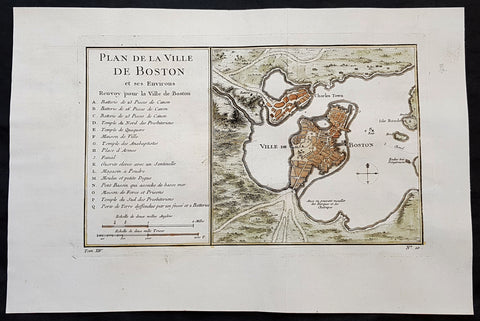
- Title : Plan de la Ville De Boston et ses Environs
- Ref #: 93417
- Size: 14 1/2in x 9 1/2in (350mm x 240mm)
- Date : 1756
- Condition: (A+) Fine Condition
Description:
This original hand coloured copper plate engraved antique map of Boston and surrounding areas - one of the earliest obtainable maps of the city - by Jacques Nicholas Bellin in 1756 - was published in the French edition of Antoine-François Prevosts 20 volume L Histoire Generale des Voyages published by Pierre de Hondt in the Hague between 1747 & 1785.
Beautiful map with great street and building detail in both Boston and Charlestown, showing parts of Ronde Isle and the mainland. Important buildings and areas identified in an idex at the left of the map. Including three cannon batteries, the Presbyterian Church, the Quaker temple, the Anabaptist Church, the City Hall, the Armory, Faneuil Hall (Spelled Fanal), etc. (Ref: Tooley; M&B)
General Definitions:
Paper thickness and quality: - Heavy and stable
Paper color : - off white
Age of map color: - Early
Colors used: - Yellow, green, blue, pink
General color appearance: - Authentic
Paper size: - 14 1/2in x 9 1/2in (350mm x 240mm)
Plate size: - 11 1/2in x 7 1/2in (285mm x 190mm)
Margins: - Min 1in (25mm)
Imperfections:
Margins: - None
Plate area: - Folds as issued
Verso: - None
Background:
Boston is the capital city and most populous municipality of the Commonwealth of Massachusetts in the United States.
Boston is one of the oldest cities in the United States, founded on the Shawmut Peninsula in 1630 by Puritan settlers from England. It was the scene of several key events of the American Revolution, such as the Boston Massacre, the Boston Tea Party, the Battle of Bunker Hill, and the Siege of Boston. Upon U.S. independence from Great Britain, it continued to be an important port and manufacturing hub as well as a center for education and culture.
In the 1820s, Boston\\\\\\\\\\\\\\\'s population grew rapidly, and the city\\\\\\\\\\\\\\\'s ethnic composition changed dramatically with the first wave of European immigrants. Irish immigrants dominated the first wave of newcomers during this period, especially following the Irish Potato Famine; by 1850, about 35,000 Irish lived in Boston. In the latter half of the 19th century, the city saw increasing numbers of Irish, Germans, Lebanese, Syrians, French Canadians, and Russian and Polish Jews settling in the city. By the end of the 19th century, Boston\\\\\\\\\\\\\\\'s core neighborhoods had become enclaves of ethnically distinct immigrants. Italians inhabited the North End, Irish dominated South Boston and Charlestown, and Russian Jews lived in the West End. Irish and Italian immigrants brought with them Roman Catholicism. Currently, Catholics make up Boston\\\\\\\\\\\\\\\'s largest religious community and the Irish have played a major role in Boston politics since the early 20th century; prominent figures include the Kennedys, Tip O\\\\\\\\\\\\\\\'Neill, and John F. Fitzgerald.
Between 1631 and 1890, the city tripled its area through land reclamation by filling in marshes, mud flats, and gaps between wharves along the waterfront. The largest reclamation efforts took place during the 19th century; beginning in 1807, the crown of Beacon Hill was used to fill in a 50-acre mill pond that later became the Haymarket Square area. The present-day State House sits atop this lowered Beacon Hill. Reclamation projects in the middle of the century created significant parts of the South End, the West End, the Financial District, and Chinatown.
After the Great Boston Fire of 1872, workers used building rubble as landfill along the downtown waterfront. During the mid- to-late 19th century, workers filled almost 600 acres of brackish Charles River marshlands west of Boston Common with gravel brought by rail from the hills of Needham Heights. The city annexed the adjacent towns of South Boston (1804), East Boston (1836), Roxbury (1868), Dorchester (including present day Mattapan and a portion of South Boston) (1870), Brighton (including present day Allston) (1874), West Roxbury (including present day Jamaica Plain and Roslindale) (1874), Charlestown (1874), and Hyde Park (1912). Other proposals were unsuccessful for the annexation of Brookline, Cambridge and Chelsea.
1756 J N Bellin Antique Map Virginia, Chesapeake Bay, Maryland & parts NJ & PA
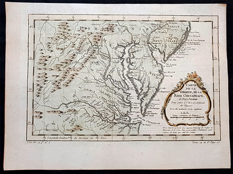
- Title : Carte de la Virginiae, De la Baye Chesapeack, et pays Voisins...
- Ref #: 93416-1
- Size: 13 1/2in x 10in (345mm x 245mm)
- Date : 1757
- Condition: (A+) Fine Condition
Description:
This original hand coloured copper plate engraved antique map of Virginia, Chesapeake Bay, Maryland & parts of New Jersey & Pennsylvania - by Jacques Nicholas Bellin in 1757 - was published in the French edition of Antoine-François Prevosts 20 volume L Histoire Generale des Voyages published by Pierre de Hondt in the Hague between 1747 & 1785.
General Definitions:
Paper thickness and quality: - Heavy and stable
Paper color : - off white
Age of map color: - Early
Colors used: - Yellow, green, blue, pink
General color appearance: - Authentic
Paper size: - 13 1/2in x 10in (345mm x 245mm)
Plate size: - 13in x 8 1/2in (330mm x 210mm)
Margins: - Min 1/2in (12mm)
Imperfections:
Margins: - Light age toning in margins
Plate area: - None
Verso: - None
Background:
In 1524, Italian explorer Giovanni da Verrazzano, (1485–1528), in service of the French crown, (famous for sailing through and thereafter naming the entrance to New York Bay as the Verrazzano Narrows, including now in the 20th century, a suspension bridge also named for him) sailed past the Chesapeake, but did not enter the Bay. Spanish explorer Lucas Vásquez de Ayllón sent an expedition out from Hispaniola in 1525 that reached the mouths of the Chesapeake and Delaware Bays. It may have been the first European expedition to explore parts of the Chesapeake Bay, which the Spaniards called Bahía de Santa María (Bay of St. Mary) or Bahía de Madre de Dios.(Bay of the Mother of God) De Ayllón established a short-lived Spanish mission settlement, San Miguel de Gualdape, in 1526 along the Atlantic coast. Many scholars doubt the assertion that it was as far north as the Chesapeake; most place it in present-day Georgias Sapelo Island. In 1573, Pedro Menéndez de Márquez, the governor of Spanish Florida, conducted further exploration of the Chesapeake. In 1570, Spanish Jesuits established the short-lived Ajacan Mission on one of the Chesapeake tributaries in present-day Virginia.
The arrival of English colonists under Sir Walter Raleigh and Humphrey Gilbert in the late 16th century to found a colony, later settled at Roanoke Island (off the present-day coast of North Carolina) for the Virginia Company, marked the first time that the English approached the gates to the Chesapeake Bay between the capes of Cape Charles and Cape Henry. Three decades later, in 1607, Europeans again entered the Bay. Captain John Smith of England explored and mapped the Bay between 1607 and 1609, resulting in the publication in 1612 back in the British Isles of A Map of Virginia. Smith wrote in his journal: Heaven and earth have never agreed better to frame a place for mans habitation. The new laying out of the Captain John Smith Chesapeake National Historic Trail, the United States first designated all-water National Historic Trail, was created in July 2006, by the National Park Service of the U.S. Department of the Interior following the route of Smiths historic 17th-century voyage. Because of economic hardships and civil strife in the Mother Land, there was a mass migration of southern English Cavaliers and their servants to the Chesapeake Bay region between 1640 and 1675, to both of the new colonies of the Province of Virginia and the Province of Maryland.
The Chesapeake Bay was the site of the Battle of the Chesapeake (also known as the Battle of the Capes, Cape Charles and Cape Henry) in 1781, during which the French fleet defeated the Royal Navy in the decisive naval battle of the American Revolutionary War. The British defeat enabled General George Washington and his French allied armies under Comte de Rochambeau to march down from New York and bottle up the rampaging southern British Army of Lord Cornwallis from the North and South Carolinas at the siege of Battle of Yorktown in Yorktown, Virginia. Their marching route from Newport, Rhode Island through Connecticut, New York State, Pennsylvania, New Jersey and Delaware to the Head of Elk by the Susquehanna River along the shores and also partially sailing down the Bay to Virginia. It is also the subject of a designated National Historic Trail under the National Park Service as the Washington-Rochambeau Revolutionary Route.
The Bay would again see conflict during War of 1812. During the year of 1813, from their base on Tangier Island, British naval forces under the command of Admiral George Cockburn raided and plundered several towns on the shores of the Chesapeake, treating the Bay as if it were a British Lake. The Chesapeake Bay Flotilla, a fleet of shallow-draft armed barges under the command of U.S. Navy Commodore Joshua Barney, was assembled to stall British shore raids and attacks. After months of harassment by Barney, the British landed on the west side of the Patuxent at Benedict, Maryland, the Chesapeake Flotilla was scuttled, and the British trekked overland to burn the U.S. Capitol in August 1814. A few days later in a pincer attack, they also sailed up the Potomac River to attack Fort Washington below the National Capital and demanded a ransom from the nearby port town of Alexandria, Virginia.
There were so-called Oyster Wars in the late 19th and early 20th centuries. Until the mid-20th century, oyster harvesting rivaled the crab industry among Chesapeake watermen, a dwindling breed whose skipjacks and other workboats were supplanted by recreational craft in the latter part of the century.
In the 1960s, the Calvert Cliffs Nuclear Power Plant on the historic Calvert Cliffs in Calvert County on the Western Shore of Maryland began using water from the Bay to cool its reactor.
1756 Nicolas Bellin Antique Map of the City of Boston & Charlestown, Harbor
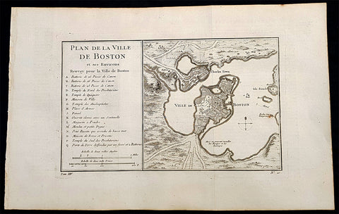
- Title : Plan De La Ville De Boston Et Ses Environs Renvoy pour la Ville de Boston...
- Date : 1756
- Condition: (A+) Fine Condition
- Ref: 93360
- Size: 16in x 10in (405mm x 255mm)
Description:
This original antique map of Boston and surrounding areas - one of the earliest obtainable maps of the city - by Jacques Nicholas Bellin in 1756 - was published in the French edition of Antoine-François Prevosts 20 volume L Histoire Generale des Voyages published by Pierre de Hondt in the Hague between 1747 & 1785.
Beautiful map with great street and building detail in both Boston and Charlestown, showing parts of Ronde Isle and the mainland. Important buildings and areas identified in an idex at the left of the map. Including three cannon batteries, the Presbyterian Church, the Quaker temple, the Anabaptist Church, the City Hall, the Armory, Faneuil Hall (Spelled Fanal), etc. (Ref: Tooley; M&B)
General Definitions:
Paper thickness and quality: - Heavy and stable
Paper color : - off white
Age of map color: -
Colors used: -
General color appearance: -
Paper size: - 16in x 10in (405mm x 255mm)
Plate size: - 11 1/2in x 7 1/2in (285mm x 190mm)
Margins: - Min 1/2in (12mm)
Imperfections:
Margins: - None
Plate area: - Folds as issued
Verso: - None
Background:
Boston is the capital city and most populous municipality of the Commonwealth of Massachusetts in the United States.
Boston is one of the oldest cities in the United States, founded on the Shawmut Peninsula in 1630 by Puritan settlers from England. It was the scene of several key events of the American Revolution, such as the Boston Massacre, the Boston Tea Party, the Battle of Bunker Hill, and the Siege of Boston. Upon U.S. independence from Great Britain, it continued to be an important port and manufacturing hub as well as a center for education and culture.
In the 1820s, Boston\\\'s population grew rapidly, and the city\\\'s ethnic composition changed dramatically with the first wave of European immigrants. Irish immigrants dominated the first wave of newcomers during this period, especially following the Irish Potato Famine; by 1850, about 35,000 Irish lived in Boston. In the latter half of the 19th century, the city saw increasing numbers of Irish, Germans, Lebanese, Syrians, French Canadians, and Russian and Polish Jews settling in the city. By the end of the 19th century, Boston\\\'s core neighborhoods had become enclaves of ethnically distinct immigrants. Italians inhabited the North End, Irish dominated South Boston and Charlestown, and Russian Jews lived in the West End. Irish and Italian immigrants brought with them Roman Catholicism. Currently, Catholics make up Boston\\\'s largest religious community and the Irish have played a major role in Boston politics since the early 20th century; prominent figures include the Kennedys, Tip O\\\'Neill, and John F. Fitzgerald.
Between 1631 and 1890, the city tripled its area through land reclamation by filling in marshes, mud flats, and gaps between wharves along the waterfront. The largest reclamation efforts took place during the 19th century; beginning in 1807, the crown of Beacon Hill was used to fill in a 50-acre mill pond that later became the Haymarket Square area. The present-day State House sits atop this lowered Beacon Hill. Reclamation projects in the middle of the century created significant parts of the South End, the West End, the Financial District, and Chinatown.
After the Great Boston Fire of 1872, workers used building rubble as landfill along the downtown waterfront. During the mid- to-late 19th century, workers filled almost 600 acres of brackish Charles River marshlands west of Boston Common with gravel brought by rail from the hills of Needham Heights. The city annexed the adjacent towns of South Boston (1804), East Boston (1836), Roxbury (1868), Dorchester (including present day Mattapan and a portion of South Boston) (1870), Brighton (including present day Allston) (1874), West Roxbury (including present day Jamaica Plain and Roslindale) (1874), Charlestown (1874), and Hyde Park (1912). Other proposals were unsuccessful for the annexation of Brookline, Cambridge and Chelsea.
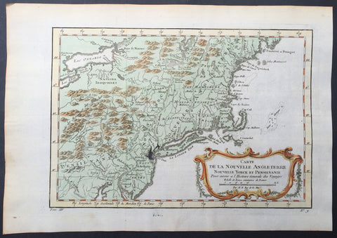
1757 Bellin Antique Map of New England, New York, New Jersey, Pennsylvania
- Title : Carte De La Nouvelle Angleterre...Par M B. 1757
- Ref #: 61097
- Size: 14 1/2in x 10in (370mm x 255mm)
- Date : 1757
- Condition: (A+) Fine Condition
Description:
This beautifully hand coloured original antique map of New England & the NE corridor of the US from Pennsylvania to Maine was engraved in 1757 - the date is engraved in the title - and was published in the 1757 French edition of Antoine-François Prevosts 20 volume L`Histoire Generale des Voyages published by Pierre de Hondt in the Hague between 1747 & 1785.
Antoine François Prévost d'Exiles 1697 - 1763, usually known simply as the Abbé Prévost, was a French author and novelist. (Ref: Tooley; M&B)
General Description:
Paper thickness and quality: - Heavy and stable
Paper color: - white
Age of map color: - Early
Colors used: - Green, yellow, red
General color appearance: - Authentic
Paper size: - 14 1/2in x 10in (370mm x 255mm)
Plate size: - 12 1/2in x 9in (320mm x 225mm)
Margins: - min. 1in (25mm)
Imperfections:
Margins: - None
Plate area: - Folds as issued, ink bleed from original plate
Verso: - None
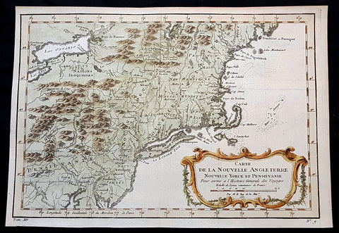
1757 J N Bellin Antique Map of of New England, Pennsylvania to New York to Maine
- Title : Carte De La Nouvelle Angleterre...Par M B. 1757
- Ref #: 92851
- Size: 12in x 9in (305mm x 235mm)
- Date : 1757
- Condition: (A+) Fine Condition
Description:
This original hand coloured copper plate engraved antique map of New England from Pennsylvania to Maine - by Jacques Nicholas Bellin in 1757 - dated - and was published in the French edition of Antoine-François Prevosts 20 volume L Histoire Generale des Voyages published by Pierre de Hondt in the Hague between 1747 & 1785.
General Definitions:
Paper thickness and quality: - Heavy and stable
Paper color : - off white
Age of map color: - Early
Colors used: - Yellow, green, blue, pink
General color appearance: - Authentic
Paper size: - 12in x 9in (305mm x 235mm)
Plate size: - 12in x 9in (305mm x 235mm)
Margins: - Min 1/2in (12mm)
Imperfections:
Margins: - None
Plate area: - Folds as issued
Verso: - None
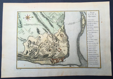
1757 Nicolas Bellin Large Antique Map of the City of Quebec, Canada
- Title : Plan de la Ville Quebec
- Size: 15in x 10in (380mm x 255mm)
- Condition: (A+) Fine Condition
- Date : 1757
- Ref #: 61091
Description:
This original copper-plate engraved beautifully hand colored antique map, a plan of the City of Quebec, by Jacques Nicolas Bellin were engraved in 1757 and were published in the French edition of Antoine-François Prevosts 20 volume L Histoire Generale des Voyages published by Pierre de Hondt in the Hague between 1747 & 1785.
General Definitions:
Paper thickness and quality: - Heavy and stable
Paper color : - off white
Age of map color: - Early
Colors used: - Yellow, green, blue, pink
General color appearance: - Authentic
Paper size: - 15in x 10in (380mm x 255mm)
Plate size: - 11in x 8 1/2in (280mm x 215mm)
Margins: - Min 1/2in (12mm)
Imperfections:
Margins: - None
Plate area: - Folds as issued
Verso: - None
Background:
Quebec City is the capital city of the Canadian province of Quebec.
Quebec City is one of the oldest European settlements in North America. While many of the major cities in Latin America date from the sixteenth century, among cities in Canada and the U.S., few were created earlier than Quebec City (St. John\\\\\\\'s, Harbour Grace, Port Royal, St. Augustine, Santa Fe, Jamestown, and Tadoussac). Also, Quebec\\\\\\\'s Old Town (Vieux-Québec) is the only North American fortified city north of Mexico whose walls still exist.
French explorer Jacques Cartier built a fort at the site in 1535, where he stayed for the winter before going back to France in spring 1536. He came back in 1541 with the goal of building a permanent settlement. This first settlement was abandoned less than one year after its foundation, in the summer 1542, due in large part to the hostility of the natives combined with the harsh living conditions during winter.
Quebec was founded by Samuel de Champlain, a French explorer and diplomat, on 3 July 1608, and at the site of a long abandoned St. Lawrence Iroquoian settlement called Stadacona. Champlain, also called The Father of New France, served as its administrator for the rest of his life.
The name Canada refers to this settlement. Although the Acadian settlement at Port-Royal was established three years earlier, Quebec came to be known as the cradle of the Francophone population of North America. The place seemed favourable to the establishment of a permanent colony.
The population of the settlement remained small for decades. In 1629 it was captured by English privateers, led by David Kirke, during the Anglo-French War. However, Samuel de Champlain argued that the English seizing of the lands was illegal as the war had already ended; he worked to have the lands returned to France. As part of the ongoing negotiations of their exit from the Anglo-French War, in 1632 the English king Charles agreed to return the lands in exchange for Louis XIII paying his wife\\\\\\\'s dowry. These terms were signed into law with the Treaty of Saint-Germain-en-Laye. The lands in Quebec and Acadia were returned to the French Company of One Hundred Associates.
In 1665, there were 550 people in 70 houses living in the city. One-quarter of the people were members of religious orders: secular priests, Jesuits, Ursulines nuns and the order running the local hospital, Hotel-Dieu.
Quebec City was the headquarters of many raids against New England during the four French and Indian Wars. In the last war, the French and Indian War (Seven Years\\\\\\\' War), Quebec City was captured by the British in 1759 and held until the end of the war in 1763. It was the site of three battles during Seven Years\\\\\\\' War - the Battle of Beauport, a French victory (31 July 1759); the Battle of the Plains of Abraham, in which British troops under General James Wolfe defeated the French General Louis-Joseph de Montcalm on 13 September 1759 and shortly thereafter took the city; and the final Battle of Sainte-Foy, a French victory (28 April 1760). France ceded New France, including the city, to Britain in 1763.
At the end of French rule in 1763, forests, villages, fields and pastures surrounded the town of 8,000 inhabitants. The town distinguished itself by its monumental architecture, fortifications, affluent homes of masonry and shacks in the suburbs of Saint-Jean and Saint-Roch. Despite its urbanity and its status as capital, Quebec City remained a small colonial city with close ties to its rural surroundings. Nearby inhabitants traded their farm surpluses and firewood for imported goods from France at the two city markets.
During the American Revolution, revolutionary troops from the southern colonies assaulted the British garrison in an attempt to liberate Quebec City, in a conflict now known as the Battle of Quebec. The defeat of the revolutionaries from the south put an end to the hopes that the peoples of Quebec would rise and join the American Revolution so that Canada would join the Continental Congress and become part of the original United States of America along with the other British colonies of continental North America. In effect, the outcome of the battle would be the effective split of British North America into two distinct political entities. The city itself was not attacked during the War of 1812, when the United States again attempted to annex Canadian lands. Fearing another American attack on Quebec City in the future, construction of the Citadelle of Quebec began in 1820. The Americans never did attack Canada after the War of 1812, but the Citadelle continued to house a large British garrison until 1871. The Citadelle is still in use by the military and is also a tourist attraction.
From the 1840s to 1867, the capital of the Province of Canada rotated between Kingston, Montreal, Toronto, Ottawa and Quebec City (from 1852 to 1856 and from 1859 to 1866).
Long before the Royal Military College of Canada was established in 1876, there were proposals for military colleges in Canada. Staffed by British Regulars, adult male students underwent a 3 month long military course in Quebec City in 1864 at the School of Military Instruction in Quebec City. Established by Militia General Order in 1864, the school enabled Officers of Militia or Candidates for Commission or promotion in the Militia to learn Military duties, drill and discipline, to command a Company at Battalion Drill, to Drill a Company at Company Drill, the internal economy of a Company and the duties of a Company\\\\\\\'s Officer. The school was retained at Confederation, in 1867. In 1868, The School of Artillery was formed in Montreal.
In 1867, Ottawa (which was chosen to be the permanent capital of the Province of Canada) was chosen by Queen Victoria to be the capital of the Dominion of Canada. The Quebec Conference on Canadian Confederation was held in the city in 1864. Throughout its over 400 years of existence, Quebec City has served as the capital for Quebec, and Canada. From 1608 to 1627 and 1632 to 1763, it was the capital of French Canada and all of New France; from 1763 to 1791, it was the capital of the Province of Quebec; from 1791 to 1841, it was the capital of Lower Canada; from 1852 to 1856 and from 1859 to 1866, it was capital of the Province of Canada; and since 1867, it has been capital of the Province of Quebec. The administrative region in which Quebec City is situated is officially referred to as Capitale-Nationale, and the term national capital is used to refer to Quebec City itself at provincial level