
Jacques Nicholas Bellin (1703 - 1772)
Profile :
A French hydrographer, geographer, and member of the French intellectual group called the philosophes.
Bellin was born in Paris. He was hydrographer of France's hydrographic office, member of the Académie de Marine and of the Royal Society of London. Over a 50-year career, he produced a large number of maps of particular interest to the Ministère de la Marine. His maps of Canada and of French territories in North America (New France, Acadia, Louisiana) are particularly valuable. He died at Versailles.
In 1721, at age 18, he was appointed hydrographer (chief cartographer) to the French Navy. In August 1741, he became the first Ingénieur de la Marine of the Depot des cartes et plans de la Marine (the French Hydrographical Office) and was named Official Hydrographer of the French King.
During his reign the Depot came out with prodigious amount of charts and maps among which was a large folio format sea-charts of France, the Neptune Francois. He also produced a number of sea-atlases of the world, e.g., the Atlas Maritime and the Hydrographie Francaise. These gained fame, distinction and respect all over Europe and were republished throughout the 18th and even in the succeeding century.
Bellin also came out with smaller format maps such as the 1764 Petit Atlas Maritime (5 vols.) containing 580 finely detailed charts.
Bellin set a very high standard of workmanship and accuracy thus gaining for France a leading role in European cartography and geography. Many of his maps were copied by other mapmakers of Europe
He was one of the Encyclopédistes, a group of 18th century intellectuals in France who compiled the 35-volume Encyclopédie which was edited by Denis Diderot and Jean le Rond d'Alembert. Bellin contributed 994 articles.
The Encyclopédistes, were part of the group called philosophes among whose members were the great minds of the Age of Enlightenment, e.g., Montesquieu, Voltaire, Rousseau, Baron d'Holbach.
Bellin contributed a number of maps to 15-vol. Histoire Generale des Voyages of Antoine François Prévost or simply known l'Abbe Prevost. One of these maps led to a geographical blunder whose impact reverberates to this day. This was the map of the Philippines which Bellin copied from a world-famous chart produced in 1734 by the Spanish missionary to the Philippines, Fr. Pedro Murillo Velarde.
Unlike many other European mapmakers of the time who outright appropriated Murillo's map, Bellin had the intellectual integrity to fully credit Murillo as his source, an open acknowledgement shown in the title cartouche of Bellin's map which came out the same year as the original work by Murillo.
Shown in Bellin's map was an island named "Limasava", a word invented in 1667 by Spanish friar, Fr. Francisco Combés, S.J., to refer to the way station of the Armada de Molucca under the command of the Portuguese captain-general Fernao de Magalhaes during its navigation in Philippine waters. Combés, who had not read a single eyewitness account of the Magellan expedition relied on two sources, the hopelessly garbled Italian translation of the Antonio Pigafetta account by Giovanni Battista Ramusio and the secondhand account by Antonio de Herrera y Tordesillas. Ramusio wrote the fleet anchored in March–April 1521 in Butuan in Mindanao, and from there sailed for Cebu with a brief stopover at "Messana". In the authentic Pigafetta account, the port was an isle named Mazzaua while the stopover isle was named Gatighan. Antonio de Herrera y Tordesillas gave a faithful narration of the Mazzaua anchorage.
Combés disregarded de Herrera's version and adopted Ramusio's. He wrote that Magellan's fleet had anchored at Butuan and from their sailed for Cebu making a stop at a way station he named Limasaua.
Five years earlier than Combés, Fr. Francisco Colín wrote the Armada moored at Butuan from March–April 1521 where Magellan and his men together with the natives celebrated an Easter Sunday mass on 31 March 1521. From Butuan the fleet sailed for Cebu making a brief stop at a way station he called "Dimasaua", an invented word meaning "this is not the Mazagua of Antonio de Herrera where supposedly an Easter Sunday mass was held which I already said happened in Butuan."
This episode was projected in the 1734 map made by Murillo who used Combés name, "Limassava" not "Dimasaua" which map Bellin copied
In 1789, Augustinian Carlo Amoretti, Italian Encyclopedist and librarian of Biblioteca Ambrosiana in Milan, discovered the authentic Italian manuscript of Antonio Pigafetta among the scattered holdings of the library. Here it came out that the port of March–April 1521 was not Butuan but Mazaua. Amoretti, who himself had not read any of five eyewitness reports of the incident including two French versions of Pigafetta's account, asserted in a footnote that Mazaua was probably the isle named Limasava in Bellin's map, thus interchanging the real port of Mazaua with the way station Gatighan.
Largely with the appearance of the eyewitness account of Ginés de Mafra, the only seaman in Magellan's fleet to return to Mazaua, whose testimony reveals a concrete, measurable description of Mazaua, the skein starting from the garbled version of Pigafetta by Ramusio to the mishandling by Combés to Bellin and finally to Amoretti has been unraveled: Pigafetta's Gatighan is Bellin's Limasava.
Published Works:
- Hydrographie française (1753)
- Carte de l'Amérique septentrionale (Map of Northern America) (1755)
- Le petit Atlas François. Recueil de Cartes et Plans des quatre parties du Monde (1758)
- Petit Atlas Maritime (1764)
- Nouvelle méthode pour apprendre la géographie (1769)
Jacques Nicholas Bellin (22)
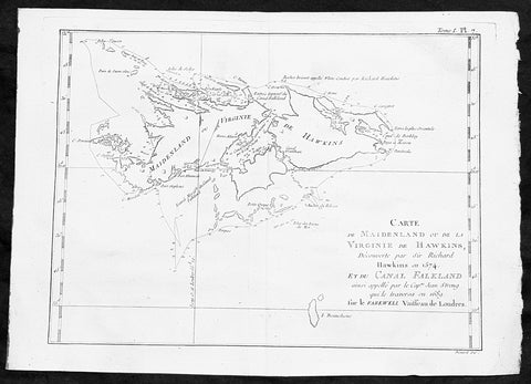
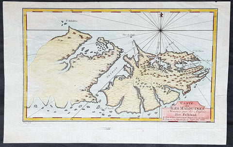
1747 Bellin Antique Map of the Falkland or Maldives Islands Argentina South America
- Title: Carte de Maidenland ou de la Virginie de Hawkins...Richard Hawkins 1574...Cap Jean Strong...1689
- Date: 1747
- Condition : (A+) Fine Condition
- Ref: 35488
- Size: 14in x 10in (360mm x 255mm)
Description:
This fine, original copper-plate engraved antique map of the Falkland Islands by Jacques Nicolas Bellin in 1750 was published in Antoine François Prevosts 15 volumes of Histoire Generale des Voyages written by Prevost & other authors between 1746-1790.
Although Fuegians from Patagonia may have visited the Falkland Islands in prehistoric times, the islands were uninhabited at the time of their discovery by Europeans. Claims of discovery date back to the 16th century, but no consensus exists on whether early explorers discovered the Falklands or other islands in the South Atlantic. The first recorded landing on the islands is attributed to English captain John Strong, who, en route to Peru\'s and Chile\'s littoral in 1690, discovered the Falkland Sound and noted the islands\' water and game.
The Falklands remained uninhabited until the 1764 establishment of Port Louis on East Falkland by French captain Louis Antoine de Bougainville, and the 1766 foundation of Port Egmont on Saunders Island by British captain John MacBride. Whether or not the settlements were aware of each other\'s existence is debated by historians. In 1766, France surrendered its claim on the Falklands to Spain, which renamed the French colony Puerto Soledad the following year. Problems began when Spain discovered and captured Port Egmont in 1770. War was narrowly avoided by its restitution to Britain in 1771.
Both the British and Spanish settlements coexisted in the archipelago until 1774, when Britain\'s new economic and strategic considerations led it to voluntarily withdraw from the islands, leaving a plaque claiming the Falklands for King George III. Spain\'s Viceroyalty of the Río de la Plata became the only governmental presence in the territory. West Falkland was left abandoned, and Puerto Soledad became mostly a prison camp.Amid the British invasions of the Río de la Plata during the Napoleonic Wars in Europe, the islands\' governor evacuated the archipelago in 1806; Spain\'s remaining colonial garrison followed suit in 1811, except for gauchos and fishermen who remained voluntarily.
General Definitions:
Paper thickness and quality: - Heavy and stable
Paper color : - off white
Age of map color: -
Colors used: -
General color appearance: -
Paper size: - 14in x 10in (355mm x 255mm)
Plate size: - 12in x 8in (305mm x 205mm)
Margins: - Min 1/2in (12mm)
Imperfections:
Margins: - None
Plate area: - None
Verso: - None
Background:
One of Antoine Francois Prevosts monumental undertakings was his history of exploration & discovery in 15 volumes titledHistoire Générale des Voyages written between 1746-1759 and was extended to 20 volumes after his death by various authors.
The 20 volumes cover the early explorations & discoveries on 3 continents: Africa (v. 1-5), Asia (v. 5-11), and America (v. 12-15) with material on the finding of the French, English, Dutch, and Portugese.
A number of notable cartographers and engravers contributed to the copper plate maps and views to the 20 volumes including Nicolas Bellin, Jan Schley, Chedel, Franc Aveline, Fessard, and many others.
The African volumes cover primarily coastal countries of West, Southern, and Eastern Africa, plus the Congo, Madagascar, Arabia and the Persian Gulf areas.
The Asian volumes cover China, Korea, Tibet, Japan, Philippines, and countries bordering the Indian Ocean.
Volume 11 includes Australia and Antarctica.
Volumes 12-15 cover voyages and discoveries in America, including the East Indies, South, Central and North America.
Volumes 16-20 include supplement volumes & tables along with continuation of voyages and discoveries in Russia, Northern Europe, America, Asia & Australia.
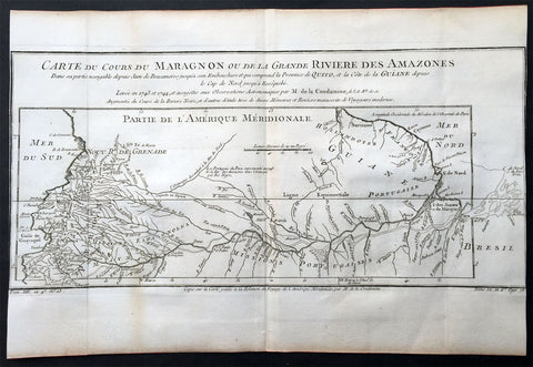
1750 Bellin & Condamine Antique Map The Course of the Amazon River South America
- Title : Carte Du Cours Du Maragnon ou De La Grande Riviere Des Amazones...1743 et 1744...par M de la Condamine
- Ref: 50686
- Size: 15in x 10in (380mm x 255mm)
- Date : 1750
- Condition: (A) Very Good Condition
Description:
This finely engraved original antique map of the course of the Amazon River - according to the discoveries of the French explorer Charles-Marie La Condamine - by Jacques Nicolas Bellin in 1750 was published in Antoine-François Prevost's monumental 20 volume edition of L`Histoire Generale des Voyages published by Pierre de Hondt, The Hague between 1747 & 1780.
Charles-Marie La Condamine (1701 - 1774) was a French mathematician and surveyor who took part in an expedition to South America to measure a degree of latitude.
La Condamine was born in Paris. He was trained for the military profession, but turned his attention to science and geographical exploration. After taking part in a scientific expedition in the Levant (1731), he became a member with Louis Godin and Pierre Bouguer of the expedition sent to Peru in 1735 to determine the length of a degree of the meridian in the neighborhood of the equator.
His associations with his principals were unhappy; the expedition was beset by many difficulties, and finally La Condamine separated from the rest and made his way from Quito down the Amazon, ultimately reaching Cayenne. His was the first scientific exploration of the Amazon. He returned to Paris in 1744 and published the results of his measurements and travels with a map of the Amazon in M' de l'Acadme des Sciences, 1745 (English translation 1745-1747). This included the first descriptions by a European of the Casiquiare canal and the curare arrow poison prepared by the Amerindians.
(Ref: Tooley; M&B)
General Description:
Paper thickness and quality: - Heavy and stable
Paper color: - off white
Age of map color: -
Colors used: -
General color appearance: -
Paper size: - 15in x 10in (380mm x 255mm)
Plate size: - 15in x 10in (380mm x 255mm)
Margins: - Min 0in (0mm)
Imperfections:
Margins: - Margins cropped to margins
Plate area: - Folds as issued
Verso: - None
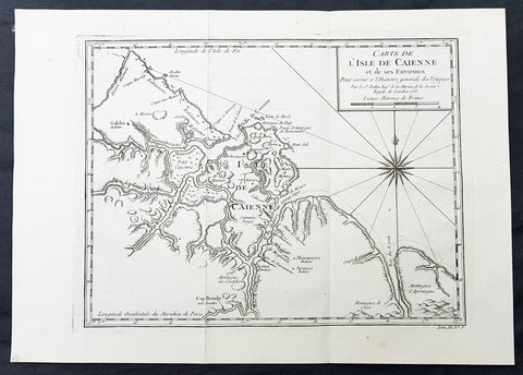
1753 Bellin Antique Map of The Island of Cayenne French Guyana, South America
- Title: Carte de L Isle De Caienne et de ses Environs...1753
- Date: 1753
- Condition : (A+) Fine Condition
- Ref: 92015
- Size: 15in x 11in (390mm x 275mm)
Description:
This fine, original copper-plate engraved antique map of the City Island of Cayenne in French Guyana, South America by Jacques Nicolas Bellin was engraved in 1753 - dated - and was published in Antoine François Prevosts 15 volumes of Histoire Generale des Voyages written by Prevost & other authors between 1746-1790.
Cayenne is the capital city of French Guiana, an overseas region and department of France located in South America. The city stands on a former island at the mouth of the Cayenne River on the Atlantic coast. The city\'s motto is fert aurum industria, which means \"work brings wealth.
Ignored by Spanish explorers, who found the region too hot and poor to be claimed, the region was not colonized until 1604, when a French settlement was founded. However, it was soon destroyed by the Portuguese, who were determined to enforce the provisions of the Treaty of Tordesillas. French colonists returned in 1643 and founded Cayenne, but they were forced to leave once more following Amerindian attacks. In 1664, France finally succeeded at establishing a permanent settlement at Cayenne. Over the next decade the colony changed hands between the French, Dutch, and English, before being restored to France. It was captured by an Anglo-Portuguese force at the invasion of Cayenne in 1809 and administered from Brazil until 1814, when it was returned to French control. It was used as a French penal colony from 1854 to 1938.
General Definitions:
Paper thickness and quality: - Heavy and stable
Paper color : - off white
Age of map color: -
Colors used: -
General color appearance: -
Paper size: - 13in x 10in (330mm x 255mm)
Plate size: - 12in x 9in (305mm x 230mm)
Margins: - Min 1/2in (12mm)
Imperfections:
Margins: - None
Plate area: - None
Verso: - None
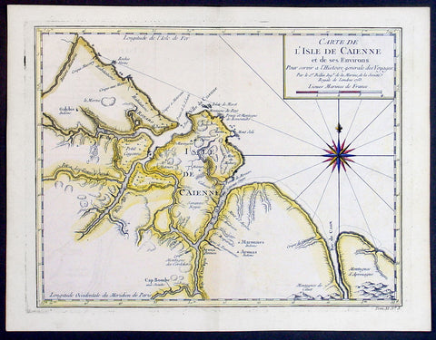
1753 Bellin Antique Map of The Island of Cayenne French Guyana, South America
- Title: Carte de L Isle De Caienne et de ses Environs...1753
- Date: 1753
- Condition : (A+) Fine Condition
- Ref: 16052
- Size: 13in x 10in (330mm x 255mm)
Description:
This fine, original copper-plate engraved antique map of the City Island of Cayenne in French Guyana, South America by Jacques Nicolas Bellin was engraved in 1753 - dated - and was published in Antoine François Prevosts 15 volumes of Histoire Generale des Voyages written by Prevost & other authors between 1746-1790.
Cayenne is the capital city of French Guiana, an overseas region and department of France located in South America. The city stands on a former island at the mouth of the Cayenne River on the Atlantic coast. The city\'s motto is fert aurum industria, which means \"work brings wealth.
Ignored by Spanish explorers, who found the region too hot and poor to be claimed, the region was not colonized until 1604, when a French settlement was founded. However, it was soon destroyed by the Portuguese, who were determined to enforce the provisions of the Treaty of Tordesillas. French colonists returned in 1643 and founded Cayenne, but they were forced to leave once more following Amerindian attacks. In 1664, France finally succeeded at establishing a permanent settlement at Cayenne. Over the next decade the colony changed hands between the French, Dutch, and English, before being restored to France. It was captured by an Anglo-Portuguese force at the invasion of Cayenne in 1809 and administered from Brazil until 1814, when it was returned to French control. It was used as a French penal colony from 1854 to 1938.
General Definitions:
Paper thickness and quality: - Heavy and stable
Paper color : - off white
Age of map color: - Early
Colors used: - Yellow, blue, red
General color appearance: - Authentic
Paper size: - 13in x 10in (330mm x 255mm)
Plate size: - 12in x 9in (305mm x 230mm)
Margins: - Min 1/2in (12mm)
Imperfections:
Margins: - None
Plate area: - None
Verso: - None
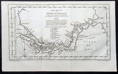
1753 Bellin Antique Map of the Magellan Straits, South America
- Title : Carte Reduite du Detroit De Magellan...1753
- Ref #: 91218
- Size: 15in x 10in (380mm x 255mm)
- Date : 1753
- Condition: (A+) Fine Condition
Description:
This fine hand coloured original antique map of the Magellan Straits between the South American mainland and Tierra Del Fuego - with major points discovered and remarked in a 9 point legend - was engraved by Jacques Nicolas Bellin in 1753 - the date is engraved in the title cartouche - and was published in Antoine-François Prevost's monumental 20 volume edition of L`Histoire Generale des Voyages published by Pierre de Hondt, The Hague between 1747 & 1780. (Ref: Tooley; M&B)
General Description:
Paper thickness and quality: - Heavy and stable
Paper color: - off white
Age of map color: - Later
Colors used: - Yellow, green, red
General color appearance: - Authentic
Paper size: - 15in x 10in (380mm x 255mm)
Plate size: - 14in x 8in (355mm x 205mm)
Margins: - Min 1/2in (12mm)
Imperfections:
Margins: - Light stain bottom right corner
Plate area: - None
Verso: - None
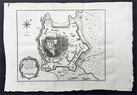
1753 Bellin Antique Map Plan of the City of Cayenne French Guyana, South America
- Title: La Ville De Cayenne...1753
- Date: 1753
- Condition : (A+) Fine Condition
- Ref: 92016
- Size: 15in x 11in (390mm x 275mm)
Description:
This beautifully engraved original antique map a plan of the city of Cayenne capital of French Guyana, South America was engraved by Jacques Nicolas Bellin in 1753 - the date is engraved in the title cartouche - and was published by Jacques Nicolas Bellin for Antoine-François Prevosts 20 volume edition of L`Histoire Generale des Voyages published by Pierre de Hondt, The Hague in 1747. (Ref: Tooley; M&B)
General Description:
Paper thickness and quality: - Heavy and stable
Paper color: - white
Age of map color: -
Colors used: -
General color appearance: -
Paper size: - 15in x 11in (390mm x 275mm)
Plate size: - 11 1/2in x 9 1/2in (290mm x 245mm)
Margins: - min. 1in (25mm)
Imperfections:
Margins: - None
Plate area: - Folds as issued
Verso: - None
Condition : (A+) Fine Condition
1753 Bellin Original Antique Map of Magellan Straits, Argentine Tierra Del Fuego
- Title : Carte Reduite du Detroit De Magellan...1753
- Ref #: 60961
- Size: 15in x 9 1/2in (380m x 240mm)
- Date : 1753
- Condition: (A+) Fine Condition
Description:
This fine, original copper-plate engraved antique map of the Magellan Straits between the South American mainland and Tierra Del Fuego map - with major points of discovery and remarks in a 9 legend points by Jacques Nicolas Bellin was engraved in 1753 - dated - and was published in Antoine-François Prevosts L Histoire Generale des VoyagesPierre de Hondt, The Hague.
General Definitions:
Paper thickness and quality: - Heavy and stable
Paper color : - off white
Age of map color: -
Colors used: -
General color appearance: -
Paper size: - 15in x 9 1/2in (380m x 240mm)
Plate size: - 14 1/2in x 8in (370mm x 205mm)
Margins: - Min 1/2in (12mm)
Imperfections:
Margins: - None
Plate area: - Folds as issued
Verso: - None
Background:
Antoine François Prevost d Exiles 1697 – 1763, usually known simply as the Abbé Prévost, was a French author and novelist.He was born at Hesdin, Artois, and first appears with the full name of Prevost d Exiles, in a letter to the booksellers of Amsterdam in 1731. His father, Lievin Prévost, was a lawyer, and several members of the family had embraced the ecclesiastical estate. Prevost was educated at the Jesuit school of Hesdin, and in 1713 became a novice of the order in Paris, pursuing his studies at the same time at the college in La Flèche.
At the end of 1716 he left the Jesuits to join the army, but soon tired of military life, and returned to Paris in 1719, apparently with the idea of resuming his novitiate. He is said to have travelled in the Netherlands about this time; in any case he returned to the army, this time with a commission. Some biographers have assumed that he suffered some of the misfortunes assigned to his hero Des Grieux. Whatever the truth, he joined the learned community of the Benedictines of St Maur, with whom he found refuge, he himself says, after the unlucky termination of a love affair. He took his vows at Jumièges in 1721 after a year\'s novitiate, and in 1726 took priests orders at St Germer de Flaix. He spent seven years in various houses of the order, teaching, preaching and studying. In 1728 he was sent to the Abbey of Saint-Germain-des-Pres, Paris, where he contributed to the Gallia Christiana, a work of historiographic documentation undertaken communally by the monks in continuation of the works of Denys de Sainte-Marthe, who had been a member of their order. His restless spirit made him seek from the Pope a transfer to the easier rule of Cluny; but he left the abbey without leave (1728), and, learning that his superiors had obtained a lettre de cachet against him, fled to England.
In London he acquired a wide knowledge of English history and literature, as can be seen in his writings. Before leaving the Benedictines Prévost had begun perhaps his most famous novel, Mémoires et aventures d’un homme de qualité qui s’est retiré du monde, the first four volumes of which were published in Paris in 1728, and two years later at Amsterdam. In 1729 he left England for the Netherlands, where he began to publish (Utrecht, 1731) a novel, the material of which, at least, had been gathered in London Le Philosophe anglais, ou Histoire de Monsieur Cleveland, fils naturel de Cromwell, ecrite par lui-même, et traduite de l anglais (Paris 1731-1739, 8 vols., but most of the existing sets are partly Paris and partly Utrecht). A spurious fifth volume (Utrecht, 1734) contained attacks on the Jesuits, and an English translation of the whole appeared in 1734.
Meanwhile, during his residence at the Hague, he engaged on a translation of De Thou\'s Historia, and, relying on the popularity of his first book, published at Amsterdam a Suite in three volumes, forming volumes v, vi, and vii of the original Mémoires et aventures d’un homme de qualite. The seventh volume contained the famous Manon Lescaut, separately published in Paris in 1731 as Histoire du Chevalier des Grieux et de Manon Lescaut. The book was eagerly read, chiefly in pirated copies, being forbidden in France. In 1733 he left the Hague for London in company of a lady whose character, according to Prevosts enemies, was doubtful. In London he edited a weekly gazette on the model of Joseph Addisons Spectator, Le Pour et contre, which he continued to produce in collaboration with the playwright Charles-Hugues Le Febvre de Saint-Marc, with short intervals, until 1740.
In the autumn of 1734 Prevost was reconciled with the Benedictines, and, returning to France, was received in the Benedictine monastery of La Croix-Saint-Leufroy in the diocese of Evreux to pass through a new, though brief, novitiate. In 1735 he was dispensed from residence in a monastery by becoming almoner to the Prince de Conti, and in 1754 obtained the priory of St Georges de Gesnes. He continued to produce novels and translations from the English, and, with the exception of a brief exile (1741–1742) spent in Brussels and Frankfurt, he resided for the most part at Chantilly until his death, which took place suddenly while he was walking in the neighbouring woods. The cause of his death, the rupture of an aneurysm, is all that is definitely known. Stories of crime and disaster were related of Prevost by his enemies, and diligently repeated, but appear to be apocryphal.
Prevosts other works include:
- Le Doyen de Killerine, Killerine, histoire morale composee sur les memoires d une illustre famille d Irlande (Paris, 1735; 2nd part, the Hague, 1739, 3rd, 4th and 5th parts, 1740)
- Tout pour l\'amour (1735), a translation of Drydens tragedy
- Histoire d une Grecque moderne (Amsterdam [Paris] 2 vols., 1740)
- l Histoire de Marguerite d Anjou (Amsterdam [Paris] 2 vols., 1740)
Memoires pour servir a l histoire de Malte (Amsterdam, 1741)
- Campagnes philosophiques, ou memoires ... contenant l histoire de la guerre d Irlande (Amsterdam, 1741)
- Histoire de Guillaume le Conquerant (Paris, 1742)
- Histoire generale des voyages (15 vols., Paris, 1746-1759), continued by other writers
- Manuel Lexique (Paris, 1750), continued by other writers
- Translations from Samuel Richardson:
Lettres anglaises ou Histoire de Miss Clarisse Harlovie (1751), from Richardson\'s Clarissa, and Nouvelles lettres anglaises, ou Histoire du chevalier Grandisson (Sir Charles Grandison, 1755).
- Mémoires pour servir a l\'histoire de la vertu (1762), from Mrs Sheridan\'s
Memoires of Miss Sidney Bidulph
- Histoire de la maison de Stuart (3 vols., 1740) from Hume\'s History of England to 1688
- Le Monde moral, ou Mémoires pour servir a l\'histoire du coeur humain (2 vols., Geneva, 1760)
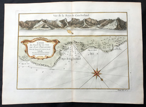
1755 Bellin Antique Map Cumberland Bay Juan Fernandez Is Chile Selkirk & Crusoe
- Title : Carte Du Nord Est de I\'Isle de Juan Fernandez
- Ref #: 25644
- Size: 14in x 10in (355mm x 255mm)
- Date : 1755
- Condition: (A+) Fine Condition
Description:
This fine, original copper-plate engraved antique map of map & view of Cumberland Bay and the Capital San Juan Bautista in the NE of Juan Fernandez Island - off the coast of Chile in the Pacific Ocean - the home of the castaway Alexander Selkirk for 4 years - by Jacques Nicolas Bellin in 1755 was published in Antoine François Prevosts 15 volumes of Histoire Generale des Voyages written by Prevost & other authors between 1746-1790.
Alexander Selkirk (1676 - 1721) was a Scottish sailor who spent four years as a castaway when he was marooned on an uninhabited island, Juan Fernández Island off the coast of Chile. It is his travels that provided the inspiration for Daniel Defoe\'s novel Robinson Crusoe.
At an early period he was engaged in buccaneer expeditions to the South Seas and in 1703 joined in with the expedition of famed privateer and explorer William Dampier. While Dampier was captain of the St. George, Selkirk served on the galley Cinque Ports, the St. George\'s companion, as a sailing master serving under Thomas Stradling.
In October 1704, after the ships had parted ways because of a dispute between Stradling and Dampier, the Cinque Ports was brought by Stradling to the uninhabited archipelago of Juan Fernández off the coast of Chile for a mid-expedition restocking of supplies and fresh water. Selkirk had grave concerns by this time about the seaworthiness of this vessel (indeed, the Cinque Ports later foundered, losing most of its hands). He tried to convince some of his crewmates to desert with him, remaining on the island; he was counting on an impending visit by another ship. No one else agreed to come along with him. Stradling declared that he would grant him his wish and leave him alone on Juan Fernández. Selkirk promptly regretted his decision. He chased and called after the boat, to no avail. Selkirk lived the next four years and four months without any human company. All he had brought with him was a musket, gunpowder, carpenter\'s tools, a knife, a Bible, some clothing and rope.
His long-anticipated rescue occurred on 1 February 1709 by way of the Duke, a privateering ship piloted by the above-mentioned William Dampier. Selkirk was discovered by the Duke\'s captain, Woodes Rogers, who referred to him as Governor of the island. Now rescued, he was almost incoherent in his joy. The agile Selkirk, catching two or three goats a day, helped restore the health of Rogers\' men. Rogers eventually made Selkirk his mate, giving him independent command of one of his ships. Rogers\' A cruising voyage round the world: first to the South-Sea, thence to the East-Indies, and homewards by the Cape of Good Hope was published in 1712 and included an account of Selkirk\'s ordeal. (Ref: Tooley; M&B)
General Definitions:
Paper thickness and quality: - Heavy and stable
Paper color : - off white
Age of map color: - Early
Colors used: - Green, yellow, orange
General color appearance: - Authentic
Paper size: - 14in x 10in (355mm x 255mm)
Plate size: - 12in x 8 1/2in (305mm x 215mm)
Margins: - Min 1/2in (12mm)
Imperfections:
Margins: - None
Plate area: - None
Verso: - None
Background:
One of Antoine Francois Prevosts monumental undertakings was his history of exploration & discovery in 15 volumes titledHistoire Générale des Voyages written between 1746-1759 and was extended to 20 volumes after his death by various authors.
The 20 volumes cover the early explorations & discoveries on 3 continents: Africa (v. 1-5), Asia (v. 5-11), and America (v. 12-15) with material on the finding of the French, English, Dutch, and Portugese.
A number of notable cartographers and engravers contributed to the copper plate maps and views to the 20 volumes including Nicolas Bellin, Jan Schley, Chedel, Franc Aveline, Fessard, and many others.
The African volumes cover primarily coastal countries of West, Southern, and Eastern Africa, plus the Congo, Madagascar, Arabia and the Persian Gulf areas.
The Asian volumes cover China, Korea, Tibet, Japan, Philippines, and countries bordering the Indian Ocean.
Volume 11 includes Australia and Antarctica.
Volumes 12-15 cover voyages and discoveries in America, including the East Indies, South, Central and North America.
Volumes 16-20 include supplement volumes & tables along with continuation of voyages and discoveries in Russia, Northern Europe, America, Asia & Australia.
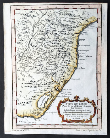
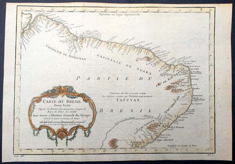
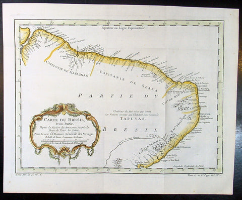
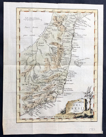
1755 Nicolas Bellin Original Antique Map of Brazil, Camarin to Cape St Marie
- Title : Suite du Bresil.
- Ref #: 61078
- Size: 10in x 7 1/2in (255mm x 190mm)
- Date : 1755
- Condition: (A+) Fine Condition
Description:
This fine, original copper-plate engraved antique map of Southern Brazil from from Camarin to Cape St Marie by Jacques Nicolas Bellin in 1755 was published in Antoine François Prevosts 15 volumes of Histoire Generale des Voyages written by Prevost & other authors between 1746-1790.
The land now called Brazil was claimed for the Portuguese Empire on 22 April 1500, with the arrival of the Portuguese fleet commanded by Pedro Álvares Cabral. The Portuguese encountered indigenous peoples divided into several tribes, most of whom spoke languages of the Tupi–Guarani family, and fought among themselves. Though the first settlement was founded in 1532, colonization effectively began in 1534, when King Dom João III of Portugal divided the territory into the fifteen private and autonomous Captaincy Colonies of Brazil.
However, the decentralized and unorganized tendencies of the captaincy colonies proved problematic, and in 1549 the Portuguese king restructured them into the Governorate General of Brazil, a single and centralized Portuguese colony in South America. In the first two centuries of colonization, Indigenous and European groups lived in constant war, establishing opportunistic alliances in order to gain advantages against each other. By the mid-16th century, cane sugar had become Brazil\'s most important exportation product, and slaves purchased in Sub-Saharan Africa, in the slave market of Western Africa (not only those from Portuguese allies of their colonies in Angola and Mozambique), had become its largest import, to cope with plantations of sugarcane, due to increasing international demand for Brazilian sugar
By the end of the 17th century, sugarcane exports began to decline, and the discovery of gold by bandeirantes in the 1690s would become the new backbone of the colony\'s economy, fostering a Brazilian Gold Rush which attracted thousands of new settlers to Brazil from Portugal and all Portuguese colonies around the world. This increased level of immigration in turn caused some conflicts between newcomers and old settlers.
Portuguese expeditions known as Bandeiras gradually advanced the Portugal colonial original frontiers in South America to approximately the current Brazilian borders. In this era other European powers tried to colonize parts of Brazil, in incursions that the Portuguese had to fight, notably the French in Rio during the 1560s, in Maranhão during the 1610s, and the Dutch in Bahia and Pernambuco, during the Dutch–Portuguese War, after the end of Iberian Union.
The Portuguese colonial administration in Brazil had two objectives that would ensure colonial order and the monopoly of Portugal\'s wealthiest and largest colony: to keep under control and eradicate all forms of slave rebellion and resistance, such as the Quilombo of Palmares, and to repress all movements for autonomy or independence, such as the Minas Conspiracy
General Definitions:
Paper thickness and quality: - Heavy and stable
Paper color : - off white
Age of map color: - Early
Colors used: - Green, Yellow,
General color appearance: - Authentic
Paper size: - 10in x 7 1/2in (255mm x 190mm)
Plate size: - 9 1/2in x 7in (240mm x 180mm)
Margins: - Min 1/2in (12mm)
Imperfections:
Margins: - None
Plate area: - None
Verso: - None
Background:
One of Antoine Francois Prevosts monumental undertakings was his history of exploration & discovery in 15 volumes titledHistoire Générale des Voyages written between 1746-1759 and was extended to 20 volumes after his death by various authors.
The 20 volumes cover the early explorations & discoveries on 3 continents: Africa (v. 1-5), Asia (v. 5-11), and America (v. 12-15) with material on the finding of the French, English, Dutch, and Portugese.
A number of notable cartographers and engravers contributed to the copper plate maps and views to the 20 volumes including Nicolas Bellin, Jan Schley, Chedel, Franc Aveline, Fessard, and many others.
The African volumes cover primarily coastal countries of West, Southern, and Eastern Africa, plus the Congo, Madagascar, Arabia and the Persian Gulf areas.
The Asian volumes cover China, Korea, Tibet, Japan, Philippines, and countries bordering the Indian Ocean.
Volume 11 includes Australia and Antarctica.
Volumes 12-15 cover voyages and discoveries in America, including the East Indies, South, Central and North America.
Volumes 16-20 include supplement volumes & tables along with continuation of voyages and discoveries in Russia, Northern Europe, America, Asia & Australia.
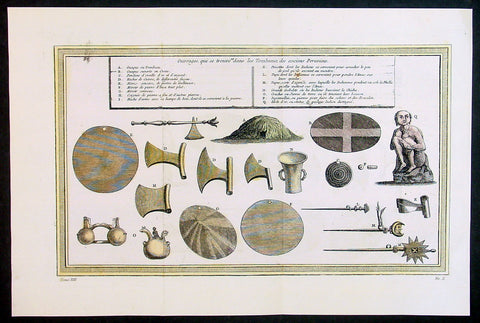
1755 Prevost & Schley Antique Print of Artifacts Recovered from Inca Burial Tomb
- Title: Puvrages qui se trouvent dans les Tombeaux des anciens Peruviens
- Date: 1755
- Condition : (A+) Fine Condition
- Ref: 34132
- Size: 15in x 10in (385mm x 255mm)
Description:
This fine, original copper-plate engraved antique print of artifacts found in an Inca Tomb in Peru by Jakob van Schley in 1755 - after De Bry - was published in Antoine François Prevosts 15 volumes of Histoire Generale des Voyages written by Prevost & other authors between 1746-1790.
The Inca Empire also known as the Incan Empire and the Inka Empire, was the largest empire in pre-Columbian America, and possibly the largest empire in the world in the early 16th century. Its political and administrative structure \"was the most sophisticated found among native peoples\" in the Americas.The administrative, political and military center of the empire was located in Cusco in modern-day Peru. The Inca civilization arose from the highlands of Peru sometime in the early 13th century. Its last stronghold was conquered by the Spanish in 1572.
From 1438 to 1533, the Incas incorporated a large portion of western South America, centered on the Andean Mountains, using conquest and peaceful assimilation, among other methods. At its largest, the empire joined Peru, large parts of modern Ecuador, western and south central Bolivia, northwest Argentina, north and central Chile and a small part of southwest Colombia into a state comparable to the historical empires of Eurasia. Its official language was Quechua.Many local forms of worship persisted in the empire, most of them concerning local sacred Huacas, but the Inca leadership encouraged the worship of Inti – their sun god – and imposed its sovereignty above other cults such as that of Pachamama. The Incas considered their king, the Sapa Inca, to be the \"son of the sun.\"
The Inca Empire was unique in that it lacked many features associated with civilization in the Old World. In the words of one scholar, \"The Incas lacked the use of wheeled vehicles. They lacked animals to ride and draft animals that could pull wagons and plows... [They] lacked the knowledge of iron and steel... Above all, they lacked a system of writing... Despite these supposed handicaps, the Incas were still able to construct one of the greatest imperial states in human history\". Notable features of the Inca Empire include its monumental architecture, especially stonework, extensive road network reaching all corners of the empire, finely-woven textiles, use of knotted strings (quipu) for record keeping and communication, agricultural innovations in a difficult environment, and the organization and management fostered or imposed on its people and their labor.
The Incan economy has been described in contradictory ways by scholars: as \"feudal, slave, socialist (here one may choose between socialist paradise or socialist tyranny)\". The Inca empire functioned largely without money and without markets. Instead, exchange of goods and services was based on reciprocity between individuals and among individuals, groups, and Inca rulers. \"Taxes\" consisted of a labor obligation of a person to the Empire. The Inca rulers (who theoretically owned all the means of production) reciprocated by granting access to land and goods and providing food and drink in celebratory feasts for their subjects.
General Definitions:
Paper thickness and quality: - Heavy and stable
Paper color : - off white
Age of map color: - Early
Colors used: - Yellow, green, red
General color appearance: - Authentic
Paper size: - 15in x 10in (385mm x 255mm)
Plate size: - 14in x 8 1/2in (355mm x 220mm)
Margins: - Min 1in (25mm)
Imperfections:
Margins: - None
Plate area: - Folds as issued
Verso: - None
Background:
One of Antoine Francois Prevosts monumental undertakings was his history of exploration & discovery in 15 volumes titledHistoire Générale des Voyages written between 1746-1759 and was extended to 20 volumes after his death by various authors.
The 20 volumes cover the early explorations & discoveries on 3 continents: Africa (v. 1-5), Asia (v. 5-11), and America (v. 12-15) with material on the finding of the French, English, Dutch, and Portugese.
A number of notable cartographers and engravers contributed to the copper plate maps and views to the 20 volumes including Nicolas Bellin, Jan Schley, Chedel, Franc Aveline, Fessard, and many others.
The African volumes cover primarily coastal countries of West, Southern, and Eastern Africa, plus the Congo, Madagascar, Arabia and the Persian Gulf areas.
The Asian volumes cover China, Korea, Tibet, Japan, Philippines, and countries bordering the Indian Ocean.
Volume 11 includes Australia and Antarctica.
Volumes 12-15 cover voyages and discoveries in America, including the East Indies, South, Central and North America.
Volumes 16-20 include supplement volumes & tables along with continuation of voyages and discoveries in Russia, Northern Europe, America, Asia & Australia.
Jakob van der Schley aka Jakob van Schley (1715 - 1779) was a Dutch draughtsman and engraver. He studied under Bernard Picart (1673-1733) whose style he subsequently copied. His main interests were engraving portraits and producing illustrations for \\\"La Vie de Marianne\\\" by Pierre Carlet de Chamblain de Marivaux (1688-1763) published in The Hague between 1735 and 1747.
He also engraved the frontispieces for a 15-volume edition of the complete works of Pierre de Brantôme (1540-1614), \\\"Oeuvres du seigneur de Brantôme\\\", published in The Hague in 1740.
He is also responsible for most of the plates in the Hague edition of Prévosts Histoire générale des voyages. (Ref: Tooley; M&B)
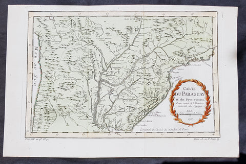
1756 Bellin Antique Map of Paraguay & Brazil, South America
- Title: Carte Du Paraguay...1756
-
Date: 1756
Condition : (A+) Fine Condition - Ref: 60939
- Size: 15in x 10in (380mm x 255mm)
Description:
This fine, original copper-plate engraved antique map of Paraguay South America, by Jacques Nicolas Bellin in 1756 was published in Antoine François Prevosts 15 volumes of Histoire Generale des Voyages written by Prevost & other authors between 1746-1790.
The first Europeansto explore the country were Spanish explorers in 1516. The Spanish explorer Juan de Salazar de Espinosa founded the settlement of Asunción on 15 August 1537. The city eventually became the center of a Spanish colonial province of Paraguay.
An attempt to create an autonomous Christian Indian nation was undertaken by Jesuit missions and settlements in this part of South America in the eighteenth century, which included portions of Uruguay, Argentina, and Brazil. They developed Jesuit reductions to bring Guarani populations together at Spanish missions and protect them from virtual slavery by Spanish settlers and Portuguese slave raiders, the Bandeirantes. In addition to seeking their conversion to Christianity. Catholicism in Paraguay was influenced by the indigenous peoples; the syncretic religion has absorbed native elements. The reducciones flourished in eastern Paraguay for about 150 years, until the expulsion of the Jesuits by the Spanish Crown in 1767. The ruins of two 18th-century Jesuit Missions of La Santísima Trinidad de Paraná and Jesús de Tavarangue have been designated as World Heritage Sites by UNESCO.
In western Paraguay Spanish settlement and Christianity were strongly resisted by the nomadic Guaycuru and other nomads from the 16th century onward. Most of these peoples were absorbed into the mestizo population in the 18th and 19th centuries.
General Definitions:
Paper thickness and quality: - Heavy and stable
Paper color : - off white
Age of map color: - Early
Colors used: - Yellow, green, red
General color appearance: - Authentic
Paper size: - 15in x 10in (380mm x 255mm)
Plate size: - 13in x 8 1/2in (330mm x 215mm)
Margins: - Min 1/2in (12mm)
Imperfections:
Margins: - None
Plate area: - Folds as issued
Verso: - None
Background:
One of Antoine Francois Prevosts monumental undertakings was his history of exploration & discovery in 15 volumes titledHistoire Générale des Voyages written between 1746-1759 and was extended to 20 volumes after his death by various authors.
The 20 volumes cover the early explorations & discoveries on 3 continents: Africa (v. 1-5), Asia (v. 5-11), and America (v. 12-15) with material on the finding of the French, English, Dutch, and Portugese.
A number of notable cartographers and engravers contributed to the copper plate maps and views to the 20 volumes including Nicolas Bellin, Jan Schley, Chedel, Franc Aveline, Fessard, and many others.
The African volumes cover primarily coastal countries of West, Southern, and Eastern Africa, plus the Congo, Madagascar, Arabia and the Persian Gulf areas.
The Asian volumes cover China, Korea, Tibet, Japan, Philippines, and countries bordering the Indian Ocean.
Volume 11 includes Australia and Antarctica.
Volumes 12-15 cover voyages and discoveries in America, including the East Indies, South, Central and North America.
Volumes 16-20 include supplement volumes & tables along with continuation of voyages and discoveries in Russia, Northern Europe, America, Asia & Australia.
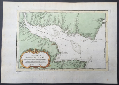
1757 Bellin Antique Map of Rio de la Plata, River Plate, Buenos Aires, Argentina
- Title : Carte de la Riviere de la Plata...
- Ref #: 61103
- Size: 10in x 7 1/2in (255mm x 190mm)
- Date : 1757
- Condition: (A+) Fine Condition
Description:
This fine, original copper-plate engraved antique map of the Río de la Plata of Argentina, by Jacques Nicolas Bellin in 1757 was published in Antoine François Prevosts 15 volumes of Histoire Generale des Voyageswritten by Prevost & other authors between 1746-1790.
The Río de la Plata River Plate in British English and La Plata River (occasionally Plata River) in other English-speaking countries — is the estuary formed by the confluence of the Uruguay and the Paraná rivers. It empties into the Atlantic Ocean, forming a funnel-shaped indentation on the southeastern coastline of South America. Depending on the geographer, the Río de la Plata may be considered a river, an estuary, a gulf or a marginal sea. For those who consider it a river—as is the case mostly in Argentina—it would be the widest river in the world, with a maximum width of about 220 kilometres.
The Río de la Plata was first explored by the Portuguese in 1512–13. The Spanish first explored it in 1516, when the navigator Juan Díaz de Solís traversed it during his search for a passage between the Atlantic and the Pacific Oceans, calling it the Mar Dulce, or \"freshwater sea.\" The Portuguese navigator Ferdinand Magellan briefly explored the estuary in 1520 before his expedition continued its circumnavigation, and in 1521 Cristóvão Jacques also explored the Plate River estuary and ascended the Parana River for the first time, entering it for about 23 leagues (around 140 km) to near the present city of Rosario.[12] The area was also visited by Francis Drake\'s fleet in early 1578, in the early stages of his circumnavigation.
Explorer Sebastian Cabot made a detailed study of the river and its tributaries and gave it its modern name. He explored the Paraná and Uruguay rivers between 1526 and 1529, ascending the Paraná as far as the present-day city of Asunción, and also explored up the Paraguay River. Cabot acquired silver trinkets trading with the Guaraní near today\'s Asunción, and these objects (together with legends of a \"Sierra de la Plata\" in the South American interior brought back by earlier explorers) inspired him to rename the river \"Río de la Plata\" (\"River of Silver\").
The first European colony was the city of Buenos Aires, founded by Pedro de Mendoza on 2 February 1536. This settlement, however, was quickly abandoned; the failure to establish a settlement on the estuary led to explorations upriver and the founding of Asunción in 1537. Buenos Aires was subsequently refounded by Juan de Garay on 11 June 1580.
The city of Buenos Aires sits along the southern coast of the Río de la Plata.
During the colonial era the Río de la Plata was made the center of the Governorate of the Río de la Plata, but the region\'s development was largely neglected by the Spanish Empire until the 1760s, when Portugal and Britain threatened to expand into the estuary. The governorate was elevated to form the Viceroyalty of the Río de la Plata in 1776. In 1806 and 1807 the river was the scene of an important British invasion that aimed to occupy the area.
General Definitions:
Paper thickness and quality: - Heavy and stable
Paper color : - off white
Age of map color: - Early
Colors used: - Green, yellow, orange
General color appearance: - Authentic
Paper size: - 14in x 10in (355mm x 255mm)
Plate size: - 12in x 8in (305mm x 205mm)
Margins: - Min 1/2in (12mm)
Imperfections:
Margins: - Light age toning in margins
Plate area: - Folds as issued
Verso: - None
Background:
One of Antoine Francois Prevosts monumental undertakings was his history of exploration & discovery in 15 volumes titledHistoire Générale des Voyages written between 1746-1759 and was extended to 20 volumes after his death by various authors.
The 20 volumes cover the early explorations & discoveries on 3 continents: Africa (v. 1-5), Asia (v. 5-11), and America (v. 12-15) with material on the finding of the French, English, Dutch, and Portugese.
A number of notable cartographers and engravers contributed to the copper plate maps and views to the 20 volumes including Nicolas Bellin, Jan Schley, Chedel, Franc Aveline, Fessard, and many others.
The African volumes cover primarily coastal countries of West, Southern, and Eastern Africa, plus the Congo, Madagascar, Arabia and the Persian Gulf areas.
The Asian volumes cover China, Korea, Tibet, Japan, Philippines, and countries bordering the Indian Ocean.
Volume 11 includes Australia and Antarctica.
Volumes 12-15 cover voyages and discoveries in America, including the East Indies, South, Central and North America.
Volumes 16-20 include supplement volumes & tables along with continuation of voyages and discoveries in Russia, Northern Europe, America, Asia & Australia.
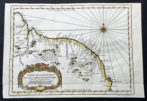
1757 Bellin Large Antique Map of Guyana, South America
- Title: Carte de la Guyana...1757
- Date: 1757
- Condition : (A+) Fine Condition
- Ref: 60940
- Size: 15in x 10in (380mm x 255mm)
Description:
This fine, original copper-plate engraved antique map of Guyana, South America by Jacques Nicolas Bellin was engraved in 1757 - dated - and was published in Antoine François Prevosts 15 volumes of Histoire Generale des Voyages written by Prevost & other authors between 1746-1790.
Guyana officially the Co-operative Republic of Guyana, is a sovereign state on the northern mainland of South America. It is, however, often considered part of the Caribbean region because of its strong cultural, historical, and political ties with other Anglo Caribbean countries and the Caribbean Community (CARICOM). Guyana is bordered by the Atlantic Ocean to the north, Brazil to the south and southwest, Suriname to the east and Venezuela to the west.
There are nine indigenous tribes residing in Guyana: the Wai Wai, Macushi, Patamona, Lokono, Kalina, Wapishana, Pemon, Akawaio and Warao. Historically the Lokono and Kalina tribes dominated Guyana. Although Christopher Columbus sighted Guyana during his third voyage (in 1498), and Sir Walter Raleigh wrote an account of its discovery in 1596, the Dutch were the first to establish colonies: Essequibo (1616), Berbice (1627), and Demerara (1752). After the British assumed control in 1796, the Dutch formally ceded the area in 1814. In 1831 the three separate colonies became a single British colony known as British Guiana.
General Definitions:
Paper thickness and quality: - Heavy and stable
Paper color : - off white
Age of map color: - Early
Colors used: - Green, yellow, orange
General color appearance: - Authentic
Paper size: - 15in x 10in (380mm x 255mm)
Plate size: - 13in x 9 1/2in (330mm x 245mm)
Margins: - Min 1/2in (12mm)
Imperfections:
Margins: - None
Plate area: - Folds as issued
Verso: - None
One of Antoine Francois Prevosts monumental undertakings was his history of exploration & discovery in 15 volumes titledHistoire Générale des Voyages written between 1746-1759 and was extended to 20 volumes after his death by various authors.
The 20 volumes cover the early explorations & discoveries on 3 continents: Africa (v. 1-5), Asia (v. 5-11), and America (v. 12-15) with material on the finding of the French, English, Dutch, and Portugese.
A number of notable cartographers and engravers contributed to the copper plate maps and views to the 20 volumes including Nicolas Bellin, Jan Schley, Chedel, Franc Aveline, Fessard, and many others.
The African volumes cover primarily coastal countries of West, Southern, and Eastern Africa, plus the Congo, Madagascar, Arabia and the Persian Gulf areas.
The Asian volumes cover China, Korea, Tibet, Japan, Philippines, and countries bordering the Indian Ocean.
Volume 11 includes Australia and Antarctica.
Volumes 12-15 cover voyages and discoveries in America, including the East Indies, South, Central and North America.
Volumes 16-20 include supplement volumes & tables along with continuation of voyages and discoveries in Russia, Northern Europe, America, Asia & Australia.
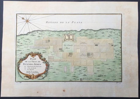
1757 Nicolas Bellin Antique Map, Plan of the City of Buenos Aires, Argentina
- Title : Plan De La Ville de Buenos - Ayres
- Ref #: 61102
- Size: 14in x 10in (355mm x 255mm)
- Date : 1757
- Condition: (A+) Fine Condition
Description:
This beautifully hand coloured original antique map* a plan of the Capital City of Argentina Buenos Aires by Jacques Nicolas Bellin was published in the 1757 French & Dutch edition of Antoine-François Prevosts 20 volume L`Histoire Generale des Voyages published by Pierre de Hondt in the Hague between 1747 & 1785.
Background: Seaman Juan Díaz de Solís, navigating in the name of Spain, was the first European to reach the Río de la Plata in 1516. His expedition was cut short when he was killed during an attack by the native Charrúa tribe in what is now Uruguay.
The city of Buenos Aires was first established as Ciudad de Nuestra Señora Santa María del Buen Ayre (literally "City of Our Lady Saint Mary of the Fair Winds") after Our Lady of Bonaria (Patroness Saint of Sardinia) on 2 February 1536 by a Spanish expedition led by Pedro de Mendoza. The settlement founded by Mendoza was located in what is today the San Telmo district of Buenos Aires, south of the city center.
More attacks by the indigenous people forced the settlers away, and in 1542 the site was abandoned. A second (and permanent) settlement was established in 11 June 1580 by Juan de Garay, who arrived by sailing down the Paraná River from Asunción (now the capital of Paraguay). He dubbed the settlement "Santísima Trinidad" and its port became "Puerto de Santa María de los Buenos Aires.
From its earliest days, Buenos Aires depended primarily on trade. During most of the 17th and 18th centuries, Spanish ships were menaced by pirates, so they developed a complex system where ships with military protection were dispatched to Central America, cross the land, from there to Lima, Peru and from it to the inner cities of the viceroyalty. Because of this, products took a very long time to arrive in Buenos Aires, and the taxes generated by the transport made them prohibitive. This scheme frustrated the traders of Buenos Aires, and a thriving contraband industry developed. This also instilled a deep resentment in porteños towards the Spanish authorities.
Sensing these feelings, Charles III of Spain progressively eased the trade restrictions and finally declared Buenos Aires an open port in the late 18th century. The capture of Porto Bello by British forces also fueled the need to foster commerce via the Atlantic route, to the detriment of Lima-based trade. One of his rulings was to split a region from the Viceroyalty of Perú and create instead the Viceroyalty of the Río de la Plata, with Buenos Aires as the capital. However, Charles's placating actions did not have the desired effect, and the porteños, some of them versed in the ideology of the French Revolution, became even more convinced of the need for independence from Spain. (Ref: Tooley; M&B)
General Description:
Paper thickness and quality: - Heavy and stable
Paper color: - off white
Age of map color: - Early
Colors used: - Yellow, green, red, brown.
General color appearance: - Authentic and fresh
Paper size: - 14in x 10in (355mm x 255mm)
Plate size: - 11 1/2in x 7 1/2in (290mm x 190mm)
Margins: - Min 1in (25mm)
Imperfections:
Margins: - Light age toning
Plate area: - Folds as issued
Verso: - None
1757 Nicolas Bellin Original Antique Map of Brazil, South America
- Title : Carte Du Bresil.....
- Ref #: 61101
- Size: 15in x 10in (380mm x 255mm)
- Date : 1757
- Condition: (A+) Fine Condition
Description:
This fine, original copper-plate engraved antique map of Brazil, South America by Jacques Nicolas Bellin in 1757 was published in Antoine François Prevosts 15 volumes of Histoire Generale des Voyages written by Prevost & other authors between 1746-1790.
The land now called Brazil was claimed for the Portuguese Empire on 22 April 1500, with the arrival of the Portuguese fleet commanded by Pedro Álvares Cabral. The Portuguese encountered indigenous peoples divided into several tribes, most of whom spoke languages of the Tupi–Guarani family, and fought among themselves. Though the first settlement was founded in 1532, colonization effectively began in 1534, when King Dom João III of Portugal divided the territory into the fifteen private and autonomous Captaincy Colonies of Brazil.
However, the decentralized and unorganized tendencies of the captaincy colonies proved problematic, and in 1549 the Portuguese king restructured them into the Governorate General of Brazil, a single and centralized Portuguese colony in South America. In the first two centuries of colonization, Indigenous and European groups lived in constant war, establishing opportunistic alliances in order to gain advantages against each other. By the mid-16th century, cane sugar had become Brazil\'s most important exportation product, and slaves purchased in Sub-Saharan Africa, in the slave market of Western Africa (not only those from Portuguese allies of their colonies in Angola and Mozambique), had become its largest import, to cope with plantations of sugarcane, due to increasing international demand for Brazilian sugar.
By the end of the 17th century, sugarcane exports began to decline, and the discovery of gold by bandeirantes in the 1690s would become the new backbone of the colony\'s economy, fostering a Brazilian Gold Rush which attracted thousands of new settlers to Brazil from Portugal and all Portuguese colonies around the world. This increased level of immigration in turn caused some conflicts between newcomers and old settlers.
Portuguese expeditions known as Bandeiras gradually advanced the Portugal colonial original frontiers in South America to approximately the current Brazilian borders. In this era other European powers tried to colonize parts of Brazil, in incursions that the Portuguese had to fight, notably the French in Rio during the 1560s, in Maranhão during the 1610s, and the Dutch in Bahia and Pernambuco, during the Dutch–Portuguese War, after the end of Iberian Union.
The Portuguese colonial administration in Brazil had two objectives that would ensure colonial order and the monopoly of Portugal\'s wealthiest and largest colony: to keep under control and eradicate all forms of slave rebellion and resistance, such as the Quilombo of Palmares, and to repress all movements for autonomy or independence, such as the Minas Conspiracy.
General Definitions:
Paper thickness and quality: - Heavy and stable
Paper color : - off white
Age of map color: - Early
Colors used: - Green, yellow, orange
General color appearance: - Authentic
Paper size: - 15in x 10in (380mm x 255mm)
Plate size: - 13in x 9 1/2in (330mm x 245mm)
Margins: - Min 1/2in (12mm)
Imperfections:
Margins: - None
Plate area: - Folds as issued
Verso: - None
ackground:
One of Antoine Francois Prevosts monumental undertakings was his history of exploration & discovery in 15 volumes titledHistoire Générale des Voyages written between 1746-1759 and was extended to 20 volumes after his death by various authors.
The 20 volumes cover the early explorations & discoveries on 3 continents: Africa (v. 1-5), Asia (v. 5-11), and America (v. 12-15) with material on the finding of the French, English, Dutch, and Portugese.
A number of notable cartographers and engravers contributed to the copper plate maps and views to the 20 volumes including Nicolas Bellin, Jan Schley, Chedel, Franc Aveline, Fessard, and many others.
The African volumes cover primarily coastal countries of West, Southern, and Eastern Africa, plus the Congo, Madagascar, Arabia and the Persian Gulf areas.
The Asian volumes cover China, Korea, Tibet, Japan, Philippines, and countries bordering the Indian Ocean.
Volume 11 includes Australia and Antarctica.
Volumes 12-15 cover voyages and discoveries in America, including the East Indies, South, Central and North America.
Volumes 16-20 include supplement volumes & tables along with continuation of voyages and discoveries in Russia, Northern Europe, America, Asia & Australia.
1757 Nicolas Bellin Original Antique Map of Brazil, South America
- Title : Carte Du Bresil.....
- Ref #: 60941
- Size: 15in x 10in (380mm x 255mm)
- Date : 1757
- Condition: (A+) Fine Condition
Description:
This fine, original copper-plate engraved antique map of Brazil, South America by Jacques Nicolas Bellin in 1757 was published in Antoine François Prevosts 15 volumes of Histoire Generale des Voyages written by Prevost & other authors between 1746-1790.
The land now called Brazil was claimed for the Portuguese Empire on 22 April 1500, with the arrival of the Portuguese fleet commanded by Pedro Álvares Cabral. The Portuguese encountered indigenous peoples divided into several tribes, most of whom spoke languages of the Tupi–Guarani family, and fought among themselves. Though the first settlement was founded in 1532, colonization effectively began in 1534, when King Dom João III of Portugal divided the territory into the fifteen private and autonomous Captaincy Colonies of Brazil.
However, the decentralized and unorganized tendencies of the captaincy colonies proved problematic, and in 1549 the Portuguese king restructured them into the Governorate General of Brazil, a single and centralized Portuguese colony in South America. In the first two centuries of colonization, Indigenous and European groups lived in constant war, establishing opportunistic alliances in order to gain advantages against each other. By the mid-16th century, cane sugar had become Brazil\'s most important exportation product, and slaves purchased in Sub-Saharan Africa, in the slave market of Western Africa (not only those from Portuguese allies of their colonies in Angola and Mozambique), had become its largest import, to cope with plantations of sugarcane, due to increasing international demand for Brazilian sugar.
By the end of the 17th century, sugarcane exports began to decline, and the discovery of gold by bandeirantes in the 1690s would become the new backbone of the colony\'s economy, fostering a Brazilian Gold Rush which attracted thousands of new settlers to Brazil from Portugal and all Portuguese colonies around the world. This increased level of immigration in turn caused some conflicts between newcomers and old settlers.
Portuguese expeditions known as Bandeiras gradually advanced the Portugal colonial original frontiers in South America to approximately the current Brazilian borders. In this era other European powers tried to colonize parts of Brazil, in incursions that the Portuguese had to fight, notably the French in Rio during the 1560s, in Maranhão during the 1610s, and the Dutch in Bahia and Pernambuco, during the Dutch–Portuguese War, after the end of Iberian Union.
The Portuguese colonial administration in Brazil had two objectives that would ensure colonial order and the monopoly of Portugal\'s wealthiest and largest colony: to keep under control and eradicate all forms of slave rebellion and resistance, such as the Quilombo of Palmares, and to repress all movements for autonomy or independence, such as the Minas Conspiracy.
General Definitions:
Paper thickness and quality: - Heavy and stable
Paper color : - off white
Age of map color: - Early
Colors used: - Green, yellow, orange
General color appearance: - Authentic
Paper size: - 15in x 10in (380mm x 255mm)
Plate size: - 13in x 9 1/2in (330mm x 245mm)
Margins: - Min 1/2in (12mm)
Imperfections:
Margins: - None
Plate area: - Folds as issued
Verso: - None
Background:
One of Antoine Francois Prevosts monumental undertakings was his history of exploration & discovery in 15 volumes titledHistoire Générale des Voyages written between 1746-1759 and was extended to 20 volumes after his death by various authors.
The 20 volumes cover the early explorations & discoveries on 3 continents: Africa (v. 1-5), Asia (v. 5-11), and America (v. 12-15) with material on the finding of the French, English, Dutch, and Portugese.
A number of notable cartographers and engravers contributed to the copper plate maps and views to the 20 volumes including Nicolas Bellin, Jan Schley, Chedel, Franc Aveline, Fessard, and many others.
The African volumes cover primarily coastal countries of West, Southern, and Eastern Africa, plus the Congo, Madagascar, Arabia and the Persian Gulf areas.
The Asian volumes cover China, Korea, Tibet, Japan, Philippines, and countries bordering the Indian Ocean.
Volume 11 includes Australia and Antarctica.
Volumes 12-15 cover voyages and discoveries in America, including the East Indies, South, Central and North America.
Volumes 16-20 include supplement volumes & tables along with continuation of voyages and discoveries in Russia, Northern Europe, America, Asia & Australia.
1760 Nicolas Bellin Antique Map of The Falkland Islands, South America
- Title : Carte des Îles Malouines
- Ref #: 93383
- Size: 15in x 9 1/2in (380mm x 235mm)
- Date : 1760
- Condition: (A+) Fine Condition
Description:
This original hand coloured copper-plate engraved antique map of the Falkland Islands by Jacques Nicolas Bellin in 1760 was published in Antoine François Prevosts 15 volumes of Histoire Generale des Voyages written by Prevost & other authors between 1746-1790.
One of Antoine Francois Prevosts monumental undertakings was his history of exploration & discovery in 15 volumes titled Histoire Générale des Voyages written between 1746-1759 and was extended to 20 volumes after his death by various authors.
The 20 volumes cover the early explorations & discoveries on 3 continents: Africa (v. 1-5), Asia (v. 5-11), and America (v. 12-15) with material on the finding of the French, English, Dutch, and Portugese.
A number of notable cartographers and engravers contributed to the copper plate maps and views to the 20 volumes including Nicolas Bellin, Jan Schley, Chedel, Franc Aveline, Fessard, and many others.
The African volumes cover primarily coastal countries of West, Southern, and Eastern Africa, plus the Congo, Madagascar, Arabia and the Persian Gulf areas.
The Asian volumes cover China, Korea, Tibet, Japan, Philippines, and countries bordering the Indian Ocean.
Volume 11 includes Australia and Antarctica.
Volumes 12-15 cover voyages and discoveries in America, including the East Indies, South, Central and North America.
Volumes 16-20 include supplement volumes & tables along with continuation of voyages and discoveries in Russia, Northern Europe, America, Asia & Australia.
General Definitions:
Paper thickness and quality: - Heavy and stable
Paper color : - off white
Age of map color: - Early
Colors used: - Yellow, green, blue, pink
General color appearance: - Authentic
Paper size: - 15in x 9 1/2in (380mm x 235mm)
Plate size: - 13in x 8in (330mm x 195mm)
Margins: - Min 1/2in (10mm)
Imperfections:
Margins: - None
Plate area: - Folds as issued
Verso: - None
Background:
Although Fuegians from Patagonia may have visited the Falkland Islands in prehistoric times, the islands were uninhabited when Europeans first discovered them. Claims of discovery date back to the 16th century, but no consensus exists on whether early explorers discovered the Falklands or other islands in the South Atlantic. The first recorded landing on the islands is attributed to English captain John Strong, who, en route to Perus and Chiles littoral in 1690, discovered the Falkland Sound and noted the islands water and game.
The Falklands remained uninhabited until the 1764 establishment of Port Louis on East Falkland by French captain Louis Antoine de Bougainville, and the 1766 foundation of Port Egmont on Saunders Island by British captain John MacBride. Whether or not the settlements were aware of each others existence is debated by historians. In 1766, France surrendered its claim on the Falklands to Spain, which renamed the French colony Puerto Soledad the following year. Problems began when Spain discovered and captured Port Egmont in 1770. War was narrowly avoided by its restitution to Britain in 1771.
Both the British and Spanish settlements coexisted in the archipelago until 1774, when Britains new economic and strategic considerations led it to voluntarily withdraw from the islands, leaving a plaque claiming the Falklands for King George III. Spains Viceroyalty of the Río de la Plata became the only governmental presence in the territory. West Falkland was left abandoned, and Puerto Soledad became mostly a prison camp. Amid the British invasions of the Río de la Plata during the Napoleonic Wars in Europe, the islands governor evacuated the archipelago in 1806; Spains remaining colonial garrison followed suit in 1811, except for gauchos and fishermen who remained voluntarily.
Thereafter, the archipelago was visited only by fishing ships; its political status was undisputed until 1820, when Colonel David Jewett, an American privateer working for the United Provinces of the Río de la Plata, informed anchored ships about Buenos Aires 1816 claim to Spains territories in the South Atlantic. Since the islands had no permanent inhabitants, in 1823 Buenos Aires granted German-born merchant Luis Vernet permission to conduct fishing activities and exploit feral cattle in the archipelago. Vernet settled at the ruins of Puerto Soledad in 1826, and accumulated resources on the islands until the venture was secure enough to bring settlers and form a permanent colony. Buenos Aires named Vernet military and civil commander of the islands in 1829, and he attempted to regulate sealing to stop the activities of foreign whalers and sealers. Vernets venture lasted until a dispute over fishing and hunting rights led to a raid by the American warship USS Lexington in 1831, when United States Navy commander Silas Duncan declared the dissolution of the islands government.
Buenos Aires attempted to retain influence over the settlement by installing a garrison, but a mutiny in 1832 was followed the next year by the arrival of British forces who reasserted Britains rule. The Argentine Confederation (headed by Buenos Aires Governor Juan Manuel de Rosas) protested against Britains actions and Argentine governments have continued since then to register official protests against Britain. The British troops departed after completing their mission, leaving the area without formal government. Vernets deputy, the Scotsman Matthew Brisbane, returned to the islands that year to restore the business, but his efforts ended after, amid unrest at Port Louis, gaucho Antonio Rivero led a group of dissatisfied individuals to murder Brisbane and the settlements senior leaders; survivors hid in a cave on a nearby island until the British returned and restored order. In 1840, the Falklands became a Crown colony, and Scottish settlers subsequently established an official pastoral community. Four years later, nearly everyone relocated to Port Jackson, considered a better location for government, and merchant Samuel Lafone began a venture to encourage British colonisation.
Stanley, as Port Jackson was soon renamed, officially became the seat of government in 1845. Early in its history, Stanley had a negative reputation due to cargo-shipping losses; only in emergencies would ships rounding Cape Horn stop at the port. Nevertheless, the Falklands geographic location proved ideal for ship repairs and the Wrecking Trade, the business of selling and buying shipwrecks and their cargoes. Aside from this trade, commercial interest in the archipelago was minimal due to the low-value hides of the feral cattle roaming the pastures. Economic growth began only after the Falkland Islands Company, which bought out Lafones failing enterprise in 1851, successfully introduced Cheviot sheep for wool farming, spurring other farms to follow suit. The high cost of importing materials, combined with the shortage of labour and consequent high wages, meant the ship repair trade became uncompetitive. After 1870, it declined as the replacement of sail ships by steamships was accelerated by the low cost of coal in South America; by 1914, with the opening of the Panama Canal, the trade effectively ended. In 1881, the Falkland Islands became financially independent of Britain. For more than a century, the Falkland Islands Company dominated the trade and employment of the archipelago; in addition, it owned most housing in Stanley, which greatly benefited from the wool trade with the UK.
1765 Nicolas Bellin Original Antique Map of Brazil, San Salvador to Sao Paulo
- Title : Suite du Bresil
- Ref #: 61077
- Size: 10in x 7 1/2in (255mm x 190mm)
- Date : 1765
- Condition: (A+) Fine Condition
Description:
This fine, original copper-plate engraved antique map of Northern Brazil from San Salvador to Sao Paulo in the south by Jacques Nicolas Bellin in 1765 was published in Antoine François Prevosts 15 volumes of Histoire Generale des Voyages written by Prevost & other authors between 1746-1790.
The land now called Brazil was claimed for the Portuguese Empire on 22 April 1500, with the arrival of the Portuguese fleet commanded by Pedro Álvares Cabral. The Portuguese encountered indigenous peoples divided into several tribes, most of whom spoke languages of the Tupi–Guarani family, and fought among themselves. Though the first settlement was founded in 1532, colonization effectively began in 1534, when King Dom João III of Portugal divided the territory into the fifteen private and autonomous Captaincy Colonies of Brazil.
However, the decentralized and unorganized tendencies of the captaincy colonies proved problematic, and in 1549 the Portuguese king restructured them into the Governorate General of Brazil, a single and centralized Portuguese colony in South America. In the first two centuries of colonization, Indigenous and European groups lived in constant war, establishing opportunistic alliances in order to gain advantages against each other. By the mid-16th century, cane sugar had become Brazil\'s most important exportation product, and slaves purchased in Sub-Saharan Africa, in the slave market of Western Africa (not only those from Portuguese allies of their colonies in Angola and Mozambique), had become its largest import, to cope with plantations of sugarcane, due to increasing international demand for Brazilian sugar
By the end of the 17th century, sugarcane exports began to decline, and the discovery of gold by bandeirantes in the 1690s would become the new backbone of the colony\'s economy, fostering a Brazilian Gold Rush which attracted thousands of new settlers to Brazil from Portugal and all Portuguese colonies around the world. This increased level of immigration in turn caused some conflicts between newcomers and old settlers.
Portuguese expeditions known as Bandeiras gradually advanced the Portugal colonial original frontiers in South America to approximately the current Brazilian borders. In this era other European powers tried to colonize parts of Brazil, in incursions that the Portuguese had to fight, notably the French in Rio during the 1560s, in Maranhão during the 1610s, and the Dutch in Bahia and Pernambuco, during the Dutch–Portuguese War, after the end of Iberian Union.
The Portuguese colonial administration in Brazil had two objectives that would ensure colonial order and the monopoly of Portugal\'s wealthiest and largest colony: to keep under control and eradicate all forms of slave rebellion and resistance, such as the Quilombo of Palmares, and to repress all movements for autonomy or independence, such as the Minas Conspiracy
General Definitions:
Paper thickness and quality: - Heavy and stable
Paper color : - off white
Age of map color: - Early
Colors used: - Green, Yellow,
General color appearance: - Authentic
Paper size: - 10in x 7 1/2in (255mm x 190mm)
Plate size: - 9in x 7in (230mm x 180mm)
Margins: - Min 1/2in (12mm)
Imperfections:
Margins: - None
Plate area: - Folds as issued
Verso: - None
Background:
One of Antoine Francois Prevosts monumental undertakings was his history of exploration & discovery in 15 volumes titledHistoire Générale des Voyages written between 1746-1759 and was extended to 20 volumes after his death by various authors.
The 20 volumes cover the early explorations & discoveries on 3 continents: Africa (v. 1-5), Asia (v. 5-11), and America (v. 12-15) with material on the finding of the French, English, Dutch, and Portugese.
A number of notable cartographers and engravers contributed to the copper plate maps and views to the 20 volumes including Nicolas Bellin, Jan Schley, Chedel, Franc Aveline, Fessard, and many others.
The African volumes cover primarily coastal countries of West, Southern, and Eastern Africa, plus the Congo, Madagascar, Arabia and the Persian Gulf areas.
The Asian volumes cover China, Korea, Tibet, Japan, Philippines, and countries bordering the Indian Ocean.
Volume 11 includes Australia and Antarctica.
Volumes 12-15 cover voyages and discoveries in America, including the East Indies, South, Central and North America.
Volumes 16-20 include supplement volumes & tables along with continuation of voyages and discoveries in Russia, Northern Europe, America, Asia & Australia.
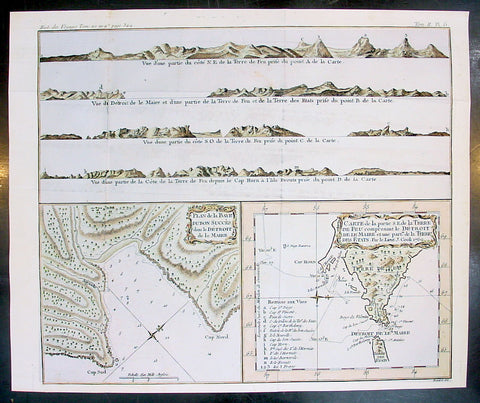
1770 Bellin Antique Map & Views Tierra del Fuego Magellan Straits, South America
- Title : Plan de Baye Dubon Succes dans le Detriot de le Maire: Carte de la Partie de la Terre De Feu comprenant le Detroit de le Marie et une Part de la Terre des Stats Par le Lieut J Cook 1769
- Ref #: 25587
- Size: 15 1/2in x 13in (395m x 330mm)
- Date : 1770
- Condition: (A+) Fine Condition
Description:
This fine, original copper-plate engraved antique map & views of Tierra del Fuego opposite the Magellan Straits as surveyed by Capt James Cook during his 2nd voyage of Discovery in 1769, by Jacques Nicolas Bellin in 1770 was published in Antoine François Prevosts 15 volumes of Histoire Generale des Voyages written by Prevost & other authors between 1746-1790.
Tierra del Fuego Spanish for \"Land of Fire\" is an archipelago off the southernmost tip of the South American mainland, across the Strait of Magellan.
The name Tierra del Fuego derives from the Portuguese explorer Ferdinand Magellan sailing for the Spanish Crown, in 1520 he was the first European to visit these lands. He believed he was seeing the many fires (fuego in Spanish) of the Yaghan, which were visible from the sea, and that the \"Indians\" were waiting in the forests to ambush his armada.
In 1525 Francisco de Hoces was the first to speculate that Tierra del Fuego was one or more islands rather than part of what was then called Terra Australis. Francis Drake in 1578 and a Dutch VOC expedition in 1616 learned more about the geography. The latter expedition named Cape Horn.
On his first voyage with the HMS Beagle in 1830, Robert FitzRoy picked up four native Fuegians, including \"Jemmy Button\" (Orundellico) and brought them to England. The surviving three were taken to London to meet the King and Queen and were, for a time, celebrities. They returned to Tierra del Fuego in the Beagle with FitzRoy and Charles Darwin, who made extensive notes about his visit to the islands.
General Definitions:
Paper thickness and quality: - Heavy and stable
Paper color : - off white
Age of map color: - Early
Colors used: - Yellow, green, red
General color appearance: - Authentic
Paper size: - 15 1/2in x 13in (395m x 330mm)
Plate size: - 15in x 12 /12in (380mm x 315mm)
Margins: - Min 1/2in (12mm)
Imperfections:
Margins: - None
Plate area: - Folds as issued
Verso: - None
Background:
One of Antoine Francois Prevosts monumental undertakings was his history of exploration & discovery in 15 volumes titledHistoire Générale des Voyages written between 1746-1759 and was extended to 20 volumes after his death by various authors.
The 20 volumes cover the early explorations & discoveries on 3 continents: Africa (v. 1-5), Asia (v. 5-11), and America (v. 12-15) with material on the finding of the French, English, Dutch, and Portugese.
A number of notable cartographers and engravers contributed to the copper plate maps and views to the 20 volumes including Nicolas Bellin, Jan Schley, Chedel, Franc Aveline, Fessard, and many others.
The African volumes cover primarily coastal countries of West, Southern, and Eastern Africa, plus the Congo, Madagascar, Arabia and the Persian Gulf areas.
The Asian volumes cover China, Korea, Tibet, Japan, Philippines, and countries bordering the Indian Ocean.
Volume 11 includes Australia and Antarctica.
Volumes 12-15 cover voyages and discoveries in America, including the East Indies, South, Central and North America.
Volumes 16-20 include supplement volumes & tables along with continuation of voyages and discoveries in Russia, Northern Europe, America, Asia & Australia.
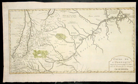
1773 Bellin Antique Map The Course of the Orinoco River South America - Rare
- Title : Cours De L Orenoque...1773
- Ref #: 92803
- Size: 18 1/2in x 11 1/2in (460mm x 295mm)
- Date : 1773
- Condition: (A+) Fine Condition
Description:
This fine, original copper-plate engraved antique map of the Orinoco River, South America, by Jacques Nicolas Bellin in 1750 was published in Antoine François Prevosts 15 volumes of Histoire Generale des Voyageswritten by Prevost & other authors between 1746-1790.
The mouth of the Orinoco River at the Atlantic Ocean was documented by Columbus on 1 August 1498, during his third voyage. Its source at the Cerro Delgado–Chalbaud, in the Parima range, was not explored until 1951, 453 years later. The source, near the Venezuelan–Brazilian border, at 1,047 metres (3,435 ft) above sea level (02°19′05″N 63°21′42″W), was explored in 1951 by a joint Venezuelan–French team.
The Orinoco Delta, and tributaries in the eastern llanos such as the Apure and Meta, were explored in the 16th century by German expeditions under Ambrosius Ehinger and his successors. In 1531 Diego de Ordaz, starting at the principal outlet in the delta, the Boca de Navios, sailed up the river to the Meta. Antonio de Berrio sailed down the Casanare to the Meta, and then down the Orinoco River and back to Coro. In 1595, after capturing de Berrio to obtain information while conducting an expedition to find the fabled city of El Dorado, the Englishman Sir Walter Raleigh sailed down the river, reaching the savannah country.
Alexander von Humboldt explored the basin in 1800, reporting on the pink river dolphins. He published extensively on the river\'s flora and fauna
General Definitions:
Paper thickness and quality: - Heavy and stable
Paper color : - off white
Age of map color: - Early
Colors used: - Yellow, green, red
General color appearance: - Authentic
Paper size: - 18 1/2in x 11 1/2in (460mm x 295mm)
Plate size: - 18in x 10in (455mm x 255mm)
Margins: - Min 1/2in (12mm)
Imperfections:
Margins: - None
Plate area: - None
Verso: - None
Background:
One of Antoine Francois Prevosts monumental undertakings was his history of exploration & discovery in 15 volumes titledHistoire Générale des Voyages written between 1746-1759 and was extended to 20 volumes after his death by various authors.
The 20 volumes cover the early explorations & discoveries on 3 continents: Africa (v. 1-5), Asia (v. 5-11), and America (v. 12-15) with material on the finding of the French, English, Dutch, and Portugese.
A number of notable cartographers and engravers contributed to the copper plate maps and views to the 20 volumes including Nicolas Bellin, Jan Schley, Chedel, Franc Aveline, Fessard, and many others.
The African volumes cover primarily coastal countries of West, Southern, and Eastern Africa, plus the Congo, Madagascar, Arabia and the Persian Gulf areas.
The Asian volumes cover China, Korea, Tibet, Japan, Philippines, and countries bordering the Indian Ocean.
Volume 11 includes Australia and Antarctica.
Volumes 12-15 cover voyages and discoveries in America, including the East Indies, South, Central and North America.
Volumes 16-20 include supplement volumes & tables along with continuation of voyages and discoveries in Russia, Northern Europe, America, Asia & Australia.
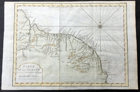
1773 Nicolas Bellin Original Antique Map of Guyana, South America
- Title: Carte De La Guiane.....
- Date: 1773
- Condition : (A+) Fine Condition
- Ref: 92804
- Size: 14in x 10in (355mm x 255mm)
Description:
This fine, original copper-plate engraved antique map of Guyana, South America by Jacques Nicolas Bellin was engraved in 1773 - dated - and was published in Antoine François Prevosts 15 volumes of Histoire Generale des Voyages written by Prevost & other authors between 1746-1790.
Guyana officially the Co-operative Republic of Guyana, is a sovereign state on the northern mainland of South America. It is, however, often considered part of the Caribbean region because of its strong cultural, historical, and political ties with other Anglo Caribbean countries and the Caribbean Community (CARICOM). Guyana is bordered by the Atlantic Ocean to the north, Brazil to the south and southwest, Suriname to the east and Venezuela to the west.
There are nine indigenous tribes residing in Guyana: the Wai Wai, Macushi, Patamona, Lokono, Kalina, Wapishana, Pemon, Akawaio and Warao. Historically the Lokono and Kalina tribes dominated Guyana. Although Christopher Columbus sighted Guyana during his third voyage (in 1498), and Sir Walter Raleigh wrote an account of its discovery in 1596, the Dutch were the first to establish colonies: Essequibo (1616), Berbice (1627), and Demerara (1752). After the British assumed control in 1796, the Dutch formally ceded the area in 1814. In 1831 the three separate colonies became a single British colony known as British Guiana.
General Definitions:
Paper thickness and quality: - Heavy and stable
Paper color : - off white
Age of map color: - Early
Colors used: - Green, yellow, red
General color appearance: - Authentic
Paper size: - 14in x 10in (355mm x 255mm)
Plate size: - 13in x 9 1/2in (330mm x 245mm)
Margins: - Min 1/2in (12mm)
Imperfections:
Margins: - None
Plate area: - Folds as issued
Verso: - None
Background:
One of Antoine Francois Prevosts monumental undertakings was his history of exploration & discovery in 15 volumes titledHistoire Générale des Voyages written between 1746-1759 and was extended to 20 volumes after his death by various authors.
The 20 volumes cover the early explorations & discoveries on 3 continents: Africa (v. 1-5), Asia (v. 5-11), and America (v. 12-15) with material on the finding of the French, English, Dutch, and Portugese.
A number of notable cartographers and engravers contributed to the copper plate maps and views to the 20 volumes including Nicolas Bellin, Jan Schley, Chedel, Franc Aveline, Fessard, and many others.
The African volumes cover primarily coastal countries of West, Southern, and Eastern Africa, plus the Congo, Madagascar, Arabia and the Persian Gulf areas.
The Asian volumes cover China, Korea, Tibet, Japan, Philippines, and countries bordering the Indian Ocean.
Volume 11 includes Australia and Antarctica.
Volumes 12-15 cover voyages and discoveries in America, including the East Indies, South, Central and North America.
Volumes 16-20 include supplement volumes & tables along with continuation of voyages and discoveries in Russia, Northern Europe, America, Asia & Australia.
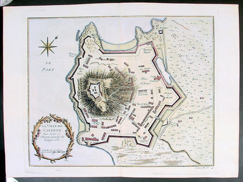
Copy of 1753 Bellin Antique Map Plan of the City of Cayenne French Guyana, South America
- Title: La Ville De Cayenne...1753
- Date: 1753
- Condition : (A+) Fine Condition
- Ref: 25648
- Size: 15in x 11in (390mm x 275mm)
Description:
This beautifully engraved original antique map a plan of the city of Cayenne capital of French Guyana, South America was engraved by Jacques Nicolas Bellin in 1753 - the date is engraved in the title cartouche - and was published by Jacques Nicolas Bellin for Antoine-François Prevosts 20 volume edition of L`Histoire Generale des Voyages published by Pierre de Hondt, The Hague in 1747. (Ref: Tooley; M&B)
General Description:
Paper thickness and quality: - Heavy and stable
Paper color: - white
Age of map color: - Early
Colors used: - Yellow, Green, red
General color appearance: - Authentic
Paper size: - 15in x 11in (390mm x 275mm)
Plate size: - 11 1/2in x 9 1/2in (290mm x 245mm)
Margins: - min. 1in (25mm)
Imperfections:
Margins: - None
Plate area: - Folds as issued
Verso: - None
Condition : (A+) Fine Condition