
Jacques Nicholas Bellin (1703 - 1772)
Profile :
A French hydrographer, geographer, and member of the French intellectual group called the philosophes.
Bellin was born in Paris. He was hydrographer of France's hydrographic office, member of the Académie de Marine and of the Royal Society of London. Over a 50-year career, he produced a large number of maps of particular interest to the Ministère de la Marine. His maps of Canada and of French territories in North America (New France, Acadia, Louisiana) are particularly valuable. He died at Versailles.
In 1721, at age 18, he was appointed hydrographer (chief cartographer) to the French Navy. In August 1741, he became the first Ingénieur de la Marine of the Depot des cartes et plans de la Marine (the French Hydrographical Office) and was named Official Hydrographer of the French King.
During his reign the Depot came out with prodigious amount of charts and maps among which was a large folio format sea-charts of France, the Neptune Francois. He also produced a number of sea-atlases of the world, e.g., the Atlas Maritime and the Hydrographie Francaise. These gained fame, distinction and respect all over Europe and were republished throughout the 18th and even in the succeeding century.
Bellin also came out with smaller format maps such as the 1764 Petit Atlas Maritime (5 vols.) containing 580 finely detailed charts.
Bellin set a very high standard of workmanship and accuracy thus gaining for France a leading role in European cartography and geography. Many of his maps were copied by other mapmakers of Europe
He was one of the Encyclopédistes, a group of 18th century intellectuals in France who compiled the 35-volume Encyclopédie which was edited by Denis Diderot and Jean le Rond d'Alembert. Bellin contributed 994 articles.
The Encyclopédistes, were part of the group called philosophes among whose members were the great minds of the Age of Enlightenment, e.g., Montesquieu, Voltaire, Rousseau, Baron d'Holbach.
Bellin contributed a number of maps to 15-vol. Histoire Generale des Voyages of Antoine François Prévost or simply known l'Abbe Prevost. One of these maps led to a geographical blunder whose impact reverberates to this day. This was the map of the Philippines which Bellin copied from a world-famous chart produced in 1734 by the Spanish missionary to the Philippines, Fr. Pedro Murillo Velarde.
Unlike many other European mapmakers of the time who outright appropriated Murillo's map, Bellin had the intellectual integrity to fully credit Murillo as his source, an open acknowledgement shown in the title cartouche of Bellin's map which came out the same year as the original work by Murillo.
Shown in Bellin's map was an island named "Limasava", a word invented in 1667 by Spanish friar, Fr. Francisco Combés, S.J., to refer to the way station of the Armada de Molucca under the command of the Portuguese captain-general Fernao de Magalhaes during its navigation in Philippine waters. Combés, who had not read a single eyewitness account of the Magellan expedition relied on two sources, the hopelessly garbled Italian translation of the Antonio Pigafetta account by Giovanni Battista Ramusio and the secondhand account by Antonio de Herrera y Tordesillas. Ramusio wrote the fleet anchored in March–April 1521 in Butuan in Mindanao, and from there sailed for Cebu with a brief stopover at "Messana". In the authentic Pigafetta account, the port was an isle named Mazzaua while the stopover isle was named Gatighan. Antonio de Herrera y Tordesillas gave a faithful narration of the Mazzaua anchorage.
Combés disregarded de Herrera's version and adopted Ramusio's. He wrote that Magellan's fleet had anchored at Butuan and from their sailed for Cebu making a stop at a way station he named Limasaua.
Five years earlier than Combés, Fr. Francisco Colín wrote the Armada moored at Butuan from March–April 1521 where Magellan and his men together with the natives celebrated an Easter Sunday mass on 31 March 1521. From Butuan the fleet sailed for Cebu making a brief stop at a way station he called "Dimasaua", an invented word meaning "this is not the Mazagua of Antonio de Herrera where supposedly an Easter Sunday mass was held which I already said happened in Butuan."
This episode was projected in the 1734 map made by Murillo who used Combés name, "Limassava" not "Dimasaua" which map Bellin copied
In 1789, Augustinian Carlo Amoretti, Italian Encyclopedist and librarian of Biblioteca Ambrosiana in Milan, discovered the authentic Italian manuscript of Antonio Pigafetta among the scattered holdings of the library. Here it came out that the port of March–April 1521 was not Butuan but Mazaua. Amoretti, who himself had not read any of five eyewitness reports of the incident including two French versions of Pigafetta's account, asserted in a footnote that Mazaua was probably the isle named Limasava in Bellin's map, thus interchanging the real port of Mazaua with the way station Gatighan.
Largely with the appearance of the eyewitness account of Ginés de Mafra, the only seaman in Magellan's fleet to return to Mazaua, whose testimony reveals a concrete, measurable description of Mazaua, the skein starting from the garbled version of Pigafetta by Ramusio to the mishandling by Combés to Bellin and finally to Amoretti has been unraveled: Pigafetta's Gatighan is Bellin's Limasava.
Published Works:
- Hydrographie française (1753)
- Carte de l'Amérique septentrionale (Map of Northern America) (1755)
- Le petit Atlas François. Recueil de Cartes et Plans des quatre parties du Monde (1758)
- Petit Atlas Maritime (1764)
- Nouvelle méthode pour apprendre la géographie (1769)
Jacques Nicholas Bellin (1)
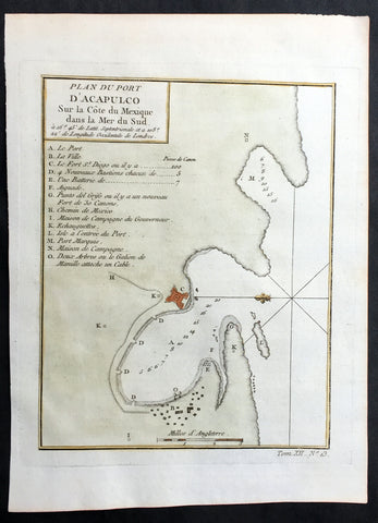
1752 Bellin Original Antique Map of Coastal City & Region of Acapulco, Mexico
- Title: Plan Du Port D Acapulco Sur la Cote du Mexique..
- Date: 1752
- Size: 10in x 7 1/4in (255mm x 185mm)
- Ref: 25804
- Condition : (A+) Fine Condition
Description:
This fine, original copper-plate engraved antique map of the Coastal city & region of Acapulco, Mexico - with legend to various places of interest - by Jacques Nicolas Bellin in 1752 was published in Antoine François Prevosts 15 volumes of Histoire Generale des Voyages written by Prevost & other authors between 1746-1790.
Acapulco de Juárez commonly called Acapulco, is a city, municipality and major seaport in the state of Guerrero on the Pacific coast of Mexico, 380 kilometres (240 mi) south of Mexico City. Acapulco is located on a deep, semicircular bay and has been a port since the early colonial period of Mexico\'s history.
There are two stories about how Acapulco bay was discovered by Europeans. The first states that two years after the Spanish conquest of the Aztec Empire, Hernán Cortés sent explorers west to find gold. The explorers had subdued this area after 1523, and Captain Saavedra Cerón was authorized by Cortés to found a settlement here. The other states that the bay was discovered on December 13, 1526 by a small ship named the El Tepache Santiago captained by Santiago Guevara. The first encomendero was established in 1525 at Cacahuatepec, which is part of the modern Acapulco municipality. In 1531, a number of Spaniards, most notably Juan Rodriguez de Villafuerte, left the Oaxaca coast and founded the village of Villafuerte where the city of Acapulco now stands. Villafuerte was unable to subdue the local native peoples, and this eventually resulted in the Yopa Rebellion in the region of Cuautepec. Hernán Cortés was obligated to send Vasco Porcayo to negotiate with the indigenous people giving concessions. The province of Acapulco became the encomendero of Rodriguez de Villafuerte who received taxes in the form of cocoa, cotton and corn
Cortés established Acapulco as a major port by the early 1530s, with the first major road between Mexico City and the port constructed by 1531. The wharf, named Marqués, was constructed by 1533 between Bruja Point and Diamond Point. Soon after, the area was made an \"alcadia\" (major province or town).
Spanish trade in the Far East would give Acapulco a prominent position in the economy of New Spain. Galleons started arriving here from Asia by 1550, and in that year thirty Spanish families were sent to live here from Mexico City to have a permanent base of European residents. Acapulco would become the second most important port, after Veracruz, due to its direct trade with the Philippines. This trade would focus on the yearly Manila-Acapulco Galleon trade, which was the nexus of all kinds of communications between New Spain, Europe and Asia. In 1573, the port was granted the monopoly of the Manila trade
The galleon trade made its yearly run from the mid-16th century until the early 19th. The luxury items it brought to New Spain attracted the attention of English and Dutch pirates, such as Francis Drake, Henry Morgan and Thomas Cavendish, who called it \"The Black Ship.\" A Dutch fleet invaded Acapulco in 1615, destroying much of the town before being driven off. The Fort of San Diego was built the following year to protect the port and the cargo of arriving ships. The fort was destroyed by an earthquake in 1776 and was rebuilt between 1778 and 1783. At the beginning of the 19th century, King Charles IV declared Acapulco a Ciudad Official and it became an essential part of the Spanish Crown. However, not long after, the Mexican War of Independence began. In 1810, José María Morelos y Pavón attacked and burnt down the city, after he defeated royalist commander Francisco Parés at the Battle of Tres Palos. The independence of Mexico in 1821 ended the run of the Manila Galleon. Acapulco\'s importance as a port recovered during the California Gold Rush in the mid-19th-century, with ships going to and coming from Panama stopping here. This city was the besieged on 19 April 1854 by Antonio López de Santa Anna after Guerrero\'s leadership had rebelled by issuing the Plan de Ayutla. After an unsuccessful week of fighting, Santa Anna retreated.
General Definitions:
Paper thickness and quality: - Heavy and stable
Paper color : - off white
Age of map color: - Early
Colors used: - Green, Yellow,
General color appearance: - Authentic
Paper size: - 10in x 7 1/2in (255m x 190mm)
Plate size: - 8n x 6in (205mm x 155mm)
Margins: - Min 1/2in (12mm)
Imperfections:
Margins: - None
Plate area: - None
Verso: - None
Background:
One of Antoine Francois Prevosts monumental undertakings was his history of exploration & discovery in 15 volumes titledHistoire Générale des Voyages written between 1746-1759 and was extended to 20 volumes after his death by various authors.
The 20 volumes cover the early explorations & discoveries on 3 continents: Africa (v. 1-5), Asia (v. 5-11), and America (v. 12-15) with material on the finding of the French, English, Dutch, and Portugese.
A number of notable cartographers and engravers contributed to the copper plate maps and views to the 20 volumes including Nicolas Bellin, Jan Schley, Chedel, Franc Aveline, Fessard, and many others.
The African volumes cover primarily coastal countries of West, Southern, and Eastern Africa, plus the Congo, Madagascar, Arabia and the Persian Gulf areas.
The Asian volumes cover China, Korea, Tibet, Japan, Philippines, and countries bordering the Indian Ocean.
Volume 11 includes Australia and Antarctica.
Volumes 12-15 cover voyages and discoveries in America, including the East Indies, South, Central and North America.
Volumes 16-20 include supplement volumes & tables along with continuation of voyages and discoveries in Russia, Northern Europe, America, Asia & Australia.