
Jacques Nicholas Bellin (1703 - 1772)
Profile :
A French hydrographer, geographer, and member of the French intellectual group called the philosophes.
Bellin was born in Paris. He was hydrographer of France's hydrographic office, member of the Académie de Marine and of the Royal Society of London. Over a 50-year career, he produced a large number of maps of particular interest to the Ministère de la Marine. His maps of Canada and of French territories in North America (New France, Acadia, Louisiana) are particularly valuable. He died at Versailles.
In 1721, at age 18, he was appointed hydrographer (chief cartographer) to the French Navy. In August 1741, he became the first Ingénieur de la Marine of the Depot des cartes et plans de la Marine (the French Hydrographical Office) and was named Official Hydrographer of the French King.
During his reign the Depot came out with prodigious amount of charts and maps among which was a large folio format sea-charts of France, the Neptune Francois. He also produced a number of sea-atlases of the world, e.g., the Atlas Maritime and the Hydrographie Francaise. These gained fame, distinction and respect all over Europe and were republished throughout the 18th and even in the succeeding century.
Bellin also came out with smaller format maps such as the 1764 Petit Atlas Maritime (5 vols.) containing 580 finely detailed charts.
Bellin set a very high standard of workmanship and accuracy thus gaining for France a leading role in European cartography and geography. Many of his maps were copied by other mapmakers of Europe
He was one of the Encyclopédistes, a group of 18th century intellectuals in France who compiled the 35-volume Encyclopédie which was edited by Denis Diderot and Jean le Rond d'Alembert. Bellin contributed 994 articles.
The Encyclopédistes, were part of the group called philosophes among whose members were the great minds of the Age of Enlightenment, e.g., Montesquieu, Voltaire, Rousseau, Baron d'Holbach.
Bellin contributed a number of maps to 15-vol. Histoire Generale des Voyages of Antoine François Prévost or simply known l'Abbe Prevost. One of these maps led to a geographical blunder whose impact reverberates to this day. This was the map of the Philippines which Bellin copied from a world-famous chart produced in 1734 by the Spanish missionary to the Philippines, Fr. Pedro Murillo Velarde.
Unlike many other European mapmakers of the time who outright appropriated Murillo's map, Bellin had the intellectual integrity to fully credit Murillo as his source, an open acknowledgement shown in the title cartouche of Bellin's map which came out the same year as the original work by Murillo.
Shown in Bellin's map was an island named "Limasava", a word invented in 1667 by Spanish friar, Fr. Francisco Combés, S.J., to refer to the way station of the Armada de Molucca under the command of the Portuguese captain-general Fernao de Magalhaes during its navigation in Philippine waters. Combés, who had not read a single eyewitness account of the Magellan expedition relied on two sources, the hopelessly garbled Italian translation of the Antonio Pigafetta account by Giovanni Battista Ramusio and the secondhand account by Antonio de Herrera y Tordesillas. Ramusio wrote the fleet anchored in March–April 1521 in Butuan in Mindanao, and from there sailed for Cebu with a brief stopover at "Messana". In the authentic Pigafetta account, the port was an isle named Mazzaua while the stopover isle was named Gatighan. Antonio de Herrera y Tordesillas gave a faithful narration of the Mazzaua anchorage.
Combés disregarded de Herrera's version and adopted Ramusio's. He wrote that Magellan's fleet had anchored at Butuan and from their sailed for Cebu making a stop at a way station he named Limasaua.
Five years earlier than Combés, Fr. Francisco Colín wrote the Armada moored at Butuan from March–April 1521 where Magellan and his men together with the natives celebrated an Easter Sunday mass on 31 March 1521. From Butuan the fleet sailed for Cebu making a brief stop at a way station he called "Dimasaua", an invented word meaning "this is not the Mazagua of Antonio de Herrera where supposedly an Easter Sunday mass was held which I already said happened in Butuan."
This episode was projected in the 1734 map made by Murillo who used Combés name, "Limassava" not "Dimasaua" which map Bellin copied
In 1789, Augustinian Carlo Amoretti, Italian Encyclopedist and librarian of Biblioteca Ambrosiana in Milan, discovered the authentic Italian manuscript of Antonio Pigafetta among the scattered holdings of the library. Here it came out that the port of March–April 1521 was not Butuan but Mazaua. Amoretti, who himself had not read any of five eyewitness reports of the incident including two French versions of Pigafetta's account, asserted in a footnote that Mazaua was probably the isle named Limasava in Bellin's map, thus interchanging the real port of Mazaua with the way station Gatighan.
Largely with the appearance of the eyewitness account of Ginés de Mafra, the only seaman in Magellan's fleet to return to Mazaua, whose testimony reveals a concrete, measurable description of Mazaua, the skein starting from the garbled version of Pigafetta by Ramusio to the mishandling by Combés to Bellin and finally to Amoretti has been unraveled: Pigafetta's Gatighan is Bellin's Limasava.
Published Works:
- Hydrographie française (1753)
- Carte de l'Amérique septentrionale (Map of Northern America) (1755)
- Le petit Atlas François. Recueil de Cartes et Plans des quatre parties du Monde (1758)
- Petit Atlas Maritime (1764)
- Nouvelle méthode pour apprendre la géographie (1769)
Jacques Nicholas Bellin (7)

1744 Nicolas Bellin Large Important Antique Map of North America, Charlevoix
- Title : Carte De La Louisiane Cours Du Mississipi et Pais Voisions Dediee a M la Comte de Maurepas...Par N Bellin Ingenieur de la Marine, 1744
- Date : 1744
- Condition: (A+) Fine Condition
- Ref: 93108
- Size: 29in x 20in (735mm x 515mm)
Description:
This large original hand coloured copper-plate engraved antique map of North America by Nicolas Bellin, in 1744 - dated - was engraved by Guillaume Dheulland (1700-1770) & published in Pierre Francois Xavier Charlevoix book on Canada & North America Histoire et Description Generale de la Nouvelle France avec Le Journal Historique d\'un Voyage fait par Ordre du Roi dans L\'Amérique Septentrionnale
Extremely important, large and much overlooked map of North America, extending from New England, The Great Lakes to Florida and west to the Rio Grande River, New Mexico, east to Santa Fe, Taos, and the known regions of the Missouri Valley. Charlevoix map provides a remarkable overview of the regions of the future United, in the first half of the 18th Century.
The map tracks to the sources of the Mississippi River and depicts 4 of the 5 Great providing the most up to date information on the Mississippi River Basin, Ohio River and the major river systems between the Mississippi River and the Appalachians.
The map is one of Bellins earliest of North America and was published map the regions described in Charlevoix Histoire et description générale de la Nouvelle France and was also compiled in part from the Chaussegros de Lery manuscripts. The map is noteworthy for the mountain range in Michigan that did not exist, with detailed text on American Indian locations and lands and notes on French forts and other early settlements and towns.
In 1720 the Duke of Orleans sent the Jesuit scholar and explorer Pierre François-Xavier de Charlevoix to America to record events in New France and Louisiana and determine the best route to the Pacific Ocean. Charlevoix gathered geographic information from fur traders in Quebec and travelled through the Great Lakes and down the Mississippi River. After he returned to France, Charlevoix published his views on North America, which has become one of the most important works on North America prior to the French & Indian, 7 years, war.
It is recorded that Thomas Jefferson owned a copy of Charlevoix book and recommended it, along with the accounts of Hennepin and Lahontan, as a particularly useful for detail in the largely unexplored regions of North America. He referred to Charlevoix book & Bellins map as he developed his own ideas of Louisiana and the Northwest.
General Definitions:
Paper thickness and quality: - Heavy and stable
Paper color : - off white
Age of map color: -
Colors used: -
General color appearance: -
Paper size: - 29in x 20in (735mm x 515mm)
Plate size: - 23in x 16 1/2in (590mm x 420mm)
Margins: - Min 1in (25mm)
Imperfections:
Margins: - Light soiling
Plate area: - None
Verso: - Light soiling
Background:
Pierre-François-Xavier de Charlevoix 1682 - 1761 was a French Jesuit priest who wrote one of the earliest descriptive accounts of North America.
Sent from France on a scientific and exploratory mission to Canada, where he had previously stayed, he traveled up the St. Lawrence River in 1720, passed through the Great Lakes, made the portage to the Mississippi River, survived shipwreck in the Gulf of Mexico, and visited the island of Santo Domingo. Returning home, he wrote Histoire de Saint-Domingue and Histoire et description générale de la Nouvelle-France the latter of much historical value.

1744 Nicolas Bellin Original Antique Map of Hudsons Bay & Surrounds, Canada
- Title : Karte Von Der Hudsons Bay Durch N Bellin..1744
- Ref #: 41156
- Size: 14in x 9 1/2in (355mm x 240mm)
- Date : 1744
- Condition: (A+) Fine Condition
Description:
This fine, original copper-plate engraved antique map of Hudsons Bay, Canada by Jacques Nicolas Bellin in 1744 was published in Antoine François Prevosts 15 volumes of Histoire Generale des Voyages written by Prevost & other authors between 1746-1790.
Hudson Bay is a large body of saltwater in northeastern Canada with a surface area of 1,230,000 km2 (470,000 sq mi). It drains a very large area, about 3,861,400 km2 (1,490,900 sq mi), that includes parts of southeastern Nunavut, Saskatchewan, Alberta, most of Manitoba, Ontario, Quebec and parts of North Dakota, South Dakota, Minnesota, and Montana. Hudson Bay\'s southern arm is called James Bay.
English explorers and colonists named Hudson Bay after Sir Henry Hudson who explored the bay beginning August 2, 1610 on his ship Discovery.:170 On his fourth voyage to North America, Hudson worked his way around Greenland\'s west coast and into the bay, mapping much of its eastern coast. Discovery became trapped in the ice over the winter, and the crew survived onshore at the southern tip of James Bay. When the ice cleared in the spring, Hudson wanted to explore the rest of the area, but the crew mutinied on June 22, 1611. They left Hudson and others adrift in a small boat. No one knows the fate of Hudson or the crew members stranded with him, but historians see no evidence that they survived for long afterwards.
In 1668, Nonsuch reached the bay and traded for beaver pelts, leading to the creation of the Hudson\'s Bay Company (HBC) which still bears the historic name. The HBC negotiated a trading monopoly from the English crown for the Hudson Bay watershed, called Rupert\'s Land. France contested this grant by sending several military expeditions to the region, but abandoned its claim in the Treaty of Utrecht (April 1713).
During this period, the Hudson\'s Bay Company built several factories (forts and trading posts) along the coast at the mouth of the major rivers (such as Fort Severn, Ontario; York Factory and Churchill, Manitoba). The strategic locations were bases for inland exploration. More importantly, they were trading posts with the indigenous peoples who came to them with furs from their trapping season. The HBC shipped the furs to Europe and continued to use some of these posts well into the 20th century.
General Definitions:
Paper thickness and quality: - Heavy and stable
Paper color : - off white
Age of map color: -
Colors used: -
General color appearance: -
Paper size: - 14in x 9 1/2in (355mm x 240mm)
Plate size: - 12in x 9in (305mm x 230mm)
Margins: - Min 1/2in (12mm)
Imperfections:
Margins: - None
Plate area: - Folds as issued
Verso: - None
Background:
One of Antoine Francois Prevosts monumental undertakings was his history of exploration & discovery in 15 volumes titledHistoire Générale des Voyages written between 1746-1759 and was extended to 20 volumes after his death by various authors.
The 20 volumes cover the early explorations & discoveries on 3 continents: Africa (v. 1-5), Asia (v. 5-11), and America (v. 12-15) with material on the finding of the French, English, Dutch, and Portugese.
A number of notable cartographers and engravers contributed to the copper plate maps and views to the 20 volumes including Nicolas Bellin, Jan Schley, Chedel, Franc Aveline, Fessard, and many others.
The African volumes cover primarily coastal countries of West, Southern, and Eastern Africa, plus the Congo, Madagascar, Arabia and the Persian Gulf areas.
The Asian volumes cover China, Korea, Tibet, Japan, Philippines, and countries bordering the Indian Ocean.
Volume 11 includes Australia and Antarctica.
Volumes 12-15 cover voyages and discoveries in America, including the East Indies, South, Central and North America.
Volumes 16-20 include supplement volumes & tables along with continuation of voyages and discoveries in Russia, Northern Europe, America, Asia & Australia.
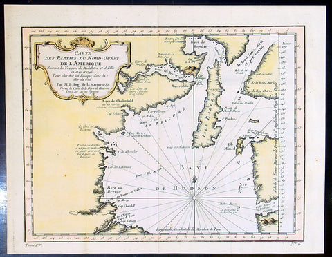
1753 Bellin & Henry Ellis Antique Map of Hudsons Bay, Search for the NW Passage
- Title : Carte Des parties Du Nord-Ouest De L Amerique..Par M.B....1753
- Ref #: 91259
- Size: 12 1/2in x 10in (320m x 255mm)
- Date : 1753
- Condition: (A+) Fine Condition
Description:
This fine, original copper-plate engraved antique map of Hudsons Bay, Canada and Henry Ellis voyage to discover the North West passage by Jacques Nicolas Bellin in 1755 was published in Antoine François Prevosts 15 volumes of Histoire Generale des Voyageswritten by Prevost & other authors between 1746-1790.
Henry Ellis 1721 – 1806 was an explorer, author, and a colonial governor of U.S. state of Georgia and Nova Scotia.
Ellis was born in County Monaghan, Ireland. He was educated in law at the Temple Church in London. In May 1746, he went out as agent of a company for the discovery of the Northwest Passage. After extinguishing with difficulty a fire in his ship, he sailed to Greenland, where he exchanged commodities with the Inuit peoples on 8 July. He then proceeded to Fort Nelson, and wintered in Hayes River. He renewed his efforts in June 1747, without success, and returned to England; where he arrived on 14 October. He published an accounts of his explorations in 1748, entitled \"Voyage made to Hudson\'s Bay in 1746, by the Dobbs Galley and The California, to discover a Northwest Passage\" and in 1750 published \"Considerations on the Great Advantages which would Arise from the Discovery of the North West Passage\". After publishing these accounts, Ellis was inducted into the Royal Society.
From 1750 to 1755, Ellis worked as a slave trader, purchasing slaves from Africa and shipping them to Jamaica.
Lord Halifax, President of the Board of Trade named Ellis lieutenant governor of Georgia, 15 August 1756. Ellis arrived at Savannah, Georgia on 16 February 1757, and on 17 May 1758, was made royal governor. His administration of the colony was highly esteemed. Recognizing the danger posed to the colony by hostile neighbors, he established a treaty with the Creeks. He published \"Heat of the Weather in Georgia\" in Philosophical trans of the Royal Society in 1758. The subtropical climate took its toll on his health, and he had to be removed from governor then left Georgia on 2 November 1760, and stopping in New York to request military assistance to the southern colonies.
After his return to England his knowledge of American affairs were called into requisition for developing the plan for taxing the colonies, and in return for this service he was rewarded with sinecure offices. From 1761 to 1763 he held the commission of governor of Nova Scotia, though he did not enter on the duties of his office. He afterward resided in Italy, principally occupied in scientific researches.Before he died he had a friendship with the creek leader.
He died on January 21, 1806 (aged 84–85) in Naples, Italy.
General Definitions:
Paper thickness and quality: - Heavy and stable
Paper color : - off white
Age of map color: - Early
Colors used: - Yellow, green, red
General color appearance: - Authentic
Paper size: - 12 1/2in x 10in (320m x 255mm)
Plate size: - 11in x 8in (280mm x 205mm)
Margins: - Min 1/2in (12mm)
Imperfections:
Margins: - None
Plate area: - Folds as issued
Verso: - None
Background:
One of Antoine Francois Prevosts monumental undertakings was his history of exploration & discovery in 15 volumes titledHistoire Générale des Voyages written between 1746-1759 and was extended to 20 volumes after his death by various authors.
The 20 volumes cover the early explorations & discoveries on 3 continents: Africa (v. 1-5), Asia (v. 5-11), and America (v. 12-15) with material on the finding of the French, English, Dutch, and Portugese.
A number of notable cartographers and engravers contributed to the copper plate maps and views to the 20 volumes including Nicolas Bellin, Jan Schley, Chedel, Franc Aveline, Fessard, and many others.
The African volumes cover primarily coastal countries of West, Southern, and Eastern Africa, plus the Congo, Madagascar, Arabia and the Persian Gulf areas.
The Asian volumes cover China, Korea, Tibet, Japan, Philippines, and countries bordering the Indian Ocean.
Volume 11 includes Australia and Antarctica.
Volumes 12-15 cover voyages and discoveries in America, including the East Indies, South, Central and North America.
Volumes 16-20 include supplement volumes & tables along with continuation of voyages and discoveries in Russia, Northern Europe, America, Asia & Australia.
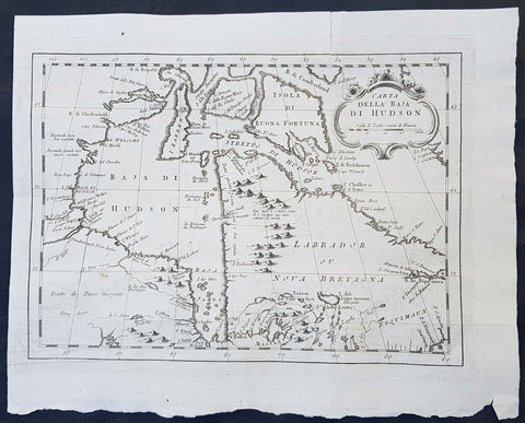
1755 Nicolas Bellin Original Antique Map of Hudsons Bay & Surrounds, Canada
- Title : Carta Della Baja Di Hudson
- Ref #: 16252
- Size: 14in x 11in (3355m x 280mm)
- Date : 1755
- Condition: (A+) Fine Condition
Description:
This fine, original copper-plate engraved antique map of Eastern Canada from Newfoundland, Quebec Province, Ontario and Hudson Bay by Jacques Nicolas Bellin was published in the 1755 edition of Antoine-François Prevosts L Histoire Generale des Voyages Pierre de Hondt, The Hague.
General Definitions:
Paper thickness and quality: - Heavy and stable
Paper color : - off white
Age of map color: -
Colors used: -
General color appearance: -
Paper size: - 14in x 11in (3355m x 280mm)
Plate size: - 12 1/2in x 9 1/2in (320mm x 240mm)
Margins: - Min 1/2in (12mm)
Imperfections:
Margins: - None
Plate area: - Folds as issued
Verso: - None
Background:
Antoine François Prevost d Exiles 1697 – 1763, usually known simply as the Abbé Prévost, was a French author and novelist.He was born at Hesdin, Artois, and first appears with the full name of Prevost d Exiles, in a letter to the booksellers of Amsterdam in 1731. His father, Lievin Prévost, was a lawyer, and several members of the family had embraced the ecclesiastical estate. Prevost was educated at the Jesuit school of Hesdin, and in 1713 became a novice of the order in Paris, pursuing his studies at the same time at the college in La Flèche.
At the end of 1716 he left the Jesuits to join the army, but soon tired of military life, and returned to Paris in 1719, apparently with the idea of resuming his novitiate. He is said to have travelled in the Netherlands about this time; in any case he returned to the army, this time with a commission. Some biographers have assumed that he suffered some of the misfortunes assigned to his hero Des Grieux. Whatever the truth, he joined the learned community of the Benedictines of St Maur, with whom he found refuge, he himself says, after the unlucky termination of a love affair. He took his vows at Jumièges in 1721 after a year\'s novitiate, and in 1726 took priests orders at St Germer de Flaix. He spent seven years in various houses of the order, teaching, preaching and studying. In 1728 he was sent to the Abbey of Saint-Germain-des-Pres, Paris, where he contributed to the Gallia Christiana, a work of historiographic documentation undertaken communally by the monks in continuation of the works of Denys de Sainte-Marthe, who had been a member of their order. His restless spirit made him seek from the Pope a transfer to the easier rule of Cluny; but he left the abbey without leave (1728), and, learning that his superiors had obtained a lettre de cachet against him, fled to England.
In London he acquired a wide knowledge of English history and literature, as can be seen in his writings. Before leaving the Benedictines Prévost had begun perhaps his most famous novel, Mémoires et aventures d’un homme de qualité qui s’est retiré du monde, the first four volumes of which were published in Paris in 1728, and two years later at Amsterdam. In 1729 he left England for the Netherlands, where he began to publish (Utrecht, 1731) a novel, the material of which, at least, had been gathered in London Le Philosophe anglais, ou Histoire de Monsieur Cleveland, fils naturel de Cromwell, ecrite par lui-même, et traduite de l anglais (Paris 1731-1739, 8 vols., but most of the existing sets are partly Paris and partly Utrecht). A spurious fifth volume (Utrecht, 1734) contained attacks on the Jesuits, and an English translation of the whole appeared in 1734.
Meanwhile, during his residence at the Hague, he engaged on a translation of De Thou\'s Historia, and, relying on the popularity of his first book, published at Amsterdam a Suite in three volumes, forming volumes v, vi, and vii of the original Mémoires et aventures d’un homme de qualite. The seventh volume contained the famous Manon Lescaut, separately published in Paris in 1731 as Histoire du Chevalier des Grieux et de Manon Lescaut. The book was eagerly read, chiefly in pirated copies, being forbidden in France. In 1733 he left the Hague for London in company of a lady whose character, according to Prevosts enemies, was doubtful. In London he edited a weekly gazette on the model of Joseph Addisons Spectator, Le Pour et contre, which he continued to produce in collaboration with the playwright Charles-Hugues Le Febvre de Saint-Marc, with short intervals, until 1740.
In the autumn of 1734 Prevost was reconciled with the Benedictines, and, returning to France, was received in the Benedictine monastery of La Croix-Saint-Leufroy in the diocese of Evreux to pass through a new, though brief, novitiate. In 1735 he was dispensed from residence in a monastery by becoming almoner to the Prince de Conti, and in 1754 obtained the priory of St Georges de Gesnes. He continued to produce novels and translations from the English, and, with the exception of a brief exile (1741–1742) spent in Brussels and Frankfurt, he resided for the most part at Chantilly until his death, which took place suddenly while he was walking in the neighbouring woods. The cause of his death, the rupture of an aneurysm, is all that is definitely known. Stories of crime and disaster were related of Prevost by his enemies, and diligently repeated, but appear to be apocryphal.
Prevosts other works include:
- Le Doyen de Killerine, Killerine, histoire morale composee sur les memoires d une illustre famille d Irlande (Paris, 1735; 2nd part, the Hague, 1739, 3rd, 4th and 5th parts, 1740)
- Tout pour l\'amour (1735), a translation of Drydens tragedy
- Histoire d une Grecque moderne (Amsterdam [Paris] 2 vols., 1740)
- l Histoire de Marguerite d Anjou (Amsterdam [Paris] 2 vols., 1740)
Memoires pour servir a l histoire de Malte (Amsterdam, 1741)
- Campagnes philosophiques, ou memoires ... contenant l histoire de la guerre d Irlande (Amsterdam, 1741)
- Histoire de Guillaume le Conquerant (Paris, 1742)
- Histoire generale des voyages (15 vols., Paris, 1746-1759), continued by other writers
- Manuel Lexique (Paris, 1750), continued by other writers
- Translations from Samuel Richardson:
Lettres anglaises ou Histoire de Miss Clarisse Harlovie (1751), from Richardson\'s Clarissa, and Nouvelles lettres anglaises, ou Histoire du chevalier Grandisson (Sir Charles Grandison, 1755).
- Mémoires pour servir a l\'histoire de la vertu (1762), from Mrs Sheridan\'s
Memoires of Miss Sidney Bidulph
- Histoire de la maison de Stuart (3 vols., 1740) from Hume\'s History of England to 1688
- Le Monde moral, ou Mémoires pour servir a l\'histoire du coeur humain (2 vols., Geneva, 1760)
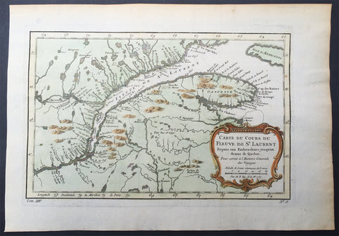
1757 Nicolas Bellin Large Antique Map Mouth of St Lawrence River Quebec, Canada
- Title : Carte Du Cours Du Fleuve De St Laurent...1757
- Size: 15in x 10in (380mm x 255mm)
- Condition: (A+) Fine Condition
- Date : 1757
- Ref #: 61087
Description:
This original copper-plate engraved beautifully hand colored antique mapof the mouth of the St Lawrence River to the city of Quebec, Canada by Jacques Nicolas Bellin was engraved in 1757 - dated - and was published in the French edition of Antoine-François Prevosts 20 volume L Histoire Generale des Voyages published by Pierre de Hondt in the Hague between 1747 & 1785.
General Definitions:
Paper thickness and quality: - Heavy and stable
Paper color : - off white
Age of map color: - Original
Colors used: - Yellow, green, blue, pink
General color appearance: - Authentic
Paper size: - 15in x 10in (380mm x 255mm)
Plate size: - 11in x 8 1/2in (280mm x 215mm)
Margins: - Min 1in (25mm)
Imperfections:
Margins: - None
Plate area: - Folds as issued
Verso: - None
Background:
The Norse explored the Gulf of Saint Lawrence in the 11th century and were followed by fifteenth and early sixteenth century European mariners, such as John Cabot, and the brothers Gaspar and Miguel Corte-Real. The first European explorer known to have sailed up the Saint Lawrence River itself was Jacques Cartier. At that time, the land along the river was inhabited by the St. Lawrence Iroquoians; at the time of Cartiers second voyage in 1535. Because Cartier arrived in the estuary on Saint Lawrences feast day, he named it the Gulf of Saint Lawrence. The Saint Lawrence River is partly within the U.S. and as such is that countrys sixth oldest surviving European place-name.
The earliest regular Europeans in the area were the Basques, who came to the St Lawrence Gulf and River in pursuit of whales from the early 16th century. The Basque whalers and fishermen traded with indigenous Americans and set up settlements, leaving vestiges all over the coast of eastern Canada and deep into the Saint Lawrence River. Basque commercial and fishing activity reached its peak before the Armada Invencibles disaster (1588), when the Spanish Basque whaling fleet was confiscated by King Philip II of Spain and largely destroyed. Initially, the whaling galleons from Labourd were not affected by the Spanish defeat.
Until the early 17th century, the French used the name Rivière du Canada to designate the Saint Lawrence upstream to Montreal and the Ottawa River after Montreal. The Saint Lawrence River served as the main route for European exploration of the North American interior, first pioneered by French explorer Samuel de Champlain.
Control of the river was crucial to British strategy to capture New France in the Seven Years War. Having captured Louisbourg in 1758, the British sailed up to Quebec the following year thanks to charts drawn up by James Cook. British troops were ferried via the Saint Lawrence to attack the city from the west, which they successfully did at the Battle of the Plains of Abraham. The river was used again by the British to defeat the French siege of Quebec under the Chevalier de Lévis in 1760.
In 1809, the first steamboat to ply its trade on the St. Lawrence was built and operated by John Molson and associates, a scant two years after Fultons steam-powered navigation of the Hudson River. The Accommodation with ten passengers made her maiden voyage from Montreal to Quebec City in 66 hours, for 30 of which she was at anchor. She had a keel of 75 feet, and length overall of 85 feet. The cost of a ticket as eight dollars upstream, and nine dollars down. She had berths that year for twenty passengers.
Within a decade, daily service was available in the hotly-contested Montreal-Quebec route.
Because of the virtually impassable Lachine Rapids, the Saint Lawrence was once continuously navigable only as far as Montreal. Opened in 1825, the Lachine Canal was the first to allow ships to pass the rapids. An extensive system of canals and locks, known as the Saint Lawrence Seaway, was officially opened on 26 June 1959 by Elizabeth II (representing Canada) and President Dwight D. Eisenhower (representing the United States). The Seaway (including the Welland Canal) now permits ocean-going vessels to pass all the way to Lake Superior.
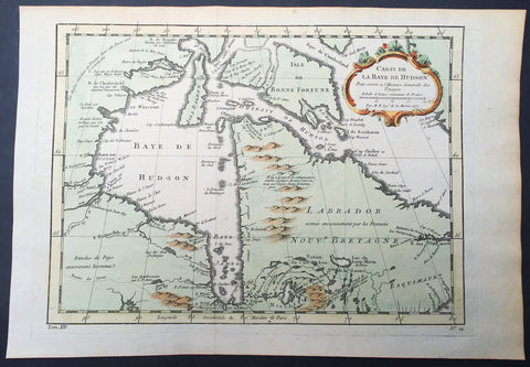
1757 Nicolas Bellin Large Antique Map of Hudsons Bay & Provinces, Canada
- Title : Carte De La Baye De Hudson...1757
- Size: 15in x 10in (380mm x 255mm)
- Condition: (A+) Fine Condition
- Date : 1757
- Ref #: 61092
Description:
This original copper-plate engraved beautifully hand colored antique map of Hudson Bay and surrounding provinces and Islands, Canada by Jacques Nicolas Bellin was engraved in 1757 - dated - and was published in the French edition of Antoine-François Prevosts 20 volume L Histoire Generale des Voyages published by Pierre de Hondt in the Hague between 1747 & 1785.
General Definitions:
Paper thickness and quality: - Heavy and stable
Paper color : - off white
Age of map color: - Original
Colors used: - Yellow, green, blue, pink
General color appearance: - Authentic
Paper size: - 15in x 10in (380mm x 255mm)
Plate size: - 11in x 8 1/2in (280mm x 215mm)
Margins: - Min 1in (25mm)
Imperfections:
Margins: - None
Plate area: - Folds as issued
Verso: - None
Background:
The Norse explored the Gulf of Saint Lawrence in the 11th century and were followed by fifteenth and early sixteenth century European mariners, such as John Cabot, and the brothers Gaspar and Miguel Corte-Real. The first European explorer known to have sailed up the Saint Lawrence River itself was Jacques Cartier. At that time, the land along the river was inhabited by the St. Lawrence Iroquoians; at the time of Cartiers second voyage in 1535. Because Cartier arrived in the estuary on Saint Lawrences feast day, he named it the Gulf of Saint Lawrence. The Saint Lawrence River is partly within the U.S. and as such is that countrys sixth oldest surviving European place-name.
The earliest regular Europeans in the area were the Basques, who came to the St Lawrence Gulf and River in pursuit of whales from the early 16th century. The Basque whalers and fishermen traded with indigenous Americans and set up settlements, leaving vestiges all over the coast of eastern Canada and deep into the Saint Lawrence River. Basque commercial and fishing activity reached its peak before the Armada Invencibles disaster (1588), when the Spanish Basque whaling fleet was confiscated by King Philip II of Spain and largely destroyed. Initially, the whaling galleons from Labourd were not affected by the Spanish defeat.
Until the early 17th century, the French used the name Rivière du Canada to designate the Saint Lawrence upstream to Montreal and the Ottawa River after Montreal. The Saint Lawrence River served as the main route for European exploration of the North American interior, first pioneered by French explorer Samuel de Champlain.
Control of the river was crucial to British strategy to capture New France in the Seven Years War. Having captured Louisbourg in 1758, the British sailed up to Quebec the following year thanks to charts drawn up by James Cook. British troops were ferried via the Saint Lawrence to attack the city from the west, which they successfully did at the Battle of the Plains of Abraham. The river was used again by the British to defeat the French siege of Quebec under the Chevalier de Lévis in 1760.
In 1809, the first steamboat to ply its trade on the St. Lawrence was built and operated by John Molson and associates, a scant two years after Fultons steam-powered navigation of the Hudson River. The Accommodation with ten passengers made her maiden voyage from Montreal to Quebec City in 66 hours, for 30 of which she was at anchor. She had a keel of 75 feet, and length overall of 85 feet. The cost of a ticket as eight dollars upstream, and nine dollars down. She had berths that year for twenty passengers.
Within a decade, daily service was available in the hotly-contested Montreal-Quebec route.
Because of the virtually impassable Lachine Rapids, the Saint Lawrence was once continuously navigable only as far as Montreal. Opened in 1825, the Lachine Canal was the first to allow ships to pass the rapids. An extensive system of canals and locks, known as the Saint Lawrence Seaway, was officially opened on 26 June 1959 by Elizabeth II (representing Canada) and President Dwight D. Eisenhower (representing the United States). The Seaway (including the Welland Canal) now permits ocean-going vessels to pass all the way to Lake Superior.
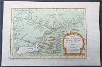
1757 Nicolas Bellin Large Antique Map St Lawrence River to Lake Ontario, Canada
- Title : Suite Du Cours De St Laurent...1757
- Size: 15in x 10in (380mm x 255mm)
- Condition: (A+) Fine Condition
- Date : 1757
- Ref #: 61090
Description:
This original copper-plate engraved beautifully hand colored antique map of the St Lawrence River to Lake Ontario, Canada by Jacques Nicolas Bellin was engraved in 1757 - dated - and was published in the French edition of Antoine-François Prevosts 20 volume L Histoire Generale des Voyages published by Pierre de Hondt in the Hague between 1747 & 1785.
General Definitions:
Paper thickness and quality: - Heavy and stable
Paper color : - off white
Age of map color: - Original
Colors used: - Yellow, green, blue, pink
General color appearance: - Authentic
Paper size: - 15in x 10in (380mm x 255mm)
Plate size: - 11in x 8 1/2in (280mm x 215mm)
Margins: - Min 1in (25mm)
Imperfections:
Margins: - None
Plate area: - Folds as issued
Verso: - None
Background:
The Norse explored the Gulf of Saint Lawrence in the 11th century and were followed by fifteenth and early sixteenth century European mariners, such as John Cabot, and the brothers Gaspar and Miguel Corte-Real. The first European explorer known to have sailed up the Saint Lawrence River itself was Jacques Cartier. At that time, the land along the river was inhabited by the St. Lawrence Iroquoians; at the time of Cartiers second voyage in 1535. Because Cartier arrived in the estuary on Saint Lawrences feast day, he named it the Gulf of Saint Lawrence. The Saint Lawrence River is partly within the U.S. and as such is that countrys sixth oldest surviving European place-name.
The earliest regular Europeans in the area were the Basques, who came to the St Lawrence Gulf and River in pursuit of whales from the early 16th century. The Basque whalers and fishermen traded with indigenous Americans and set up settlements, leaving vestiges all over the coast of eastern Canada and deep into the Saint Lawrence River. Basque commercial and fishing activity reached its peak before the Armada Invencibles disaster (1588), when the Spanish Basque whaling fleet was confiscated by King Philip II of Spain and largely destroyed. Initially, the whaling galleons from Labourd were not affected by the Spanish defeat.
Until the early 17th century, the French used the name Rivière du Canada to designate the Saint Lawrence upstream to Montreal and the Ottawa River after Montreal. The Saint Lawrence River served as the main route for European exploration of the North American interior, first pioneered by French explorer Samuel de Champlain.
Control of the river was crucial to British strategy to capture New France in the Seven Years War. Having captured Louisbourg in 1758, the British sailed up to Quebec the following year thanks to charts drawn up by James Cook. British troops were ferried via the Saint Lawrence to attack the city from the west, which they successfully did at the Battle of the Plains of Abraham. The river was used again by the British to defeat the French siege of Quebec under the Chevalier de Lévis in 1760.
In 1809, the first steamboat to ply its trade on the St. Lawrence was built and operated by John Molson and associates, a scant two years after Fultons steam-powered navigation of the Hudson River. The Accommodation with ten passengers made her maiden voyage from Montreal to Quebec City in 66 hours, for 30 of which she was at anchor. She had a keel of 75 feet, and length overall of 85 feet. The cost of a ticket as eight dollars upstream, and nine dollars down. She had berths that year for twenty passengers.
Within a decade, daily service was available in the hotly-contested Montreal-Quebec route.
Because of the virtually impassable Lachine Rapids, the Saint Lawrence was once continuously navigable only as far as Montreal. Opened in 1825, the Lachine Canal was the first to allow ships to pass the rapids. An extensive system of canals and locks, known as the Saint Lawrence Seaway, was officially opened on 26 June 1959 by Elizabeth II (representing Canada) and President Dwight D. Eisenhower (representing the United States). The Seaway (including the Welland Canal) now permits ocean-going vessels to pass all the way to Lake Superior.