Australia/Oceania (3)
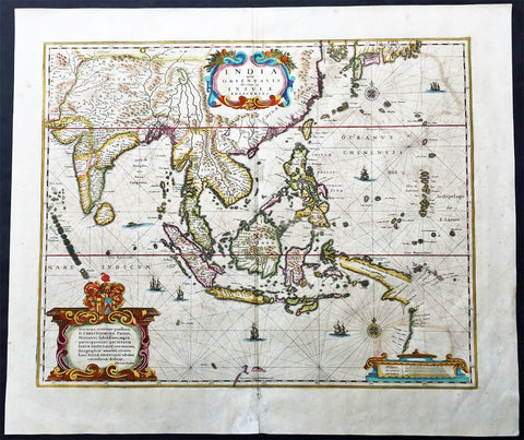
1639 Hondius Antique Map of Australia, East Indies, India to China - Duyfken
- Title : India quae Orientalis dicitur et Insulae Adiacentes
- Date : 1639
- Condition: (A+) Fine Condition
- Ref: 43140
- Size: 22 1/2in x 19 1/4in (570mm x 485mm)
Description:
This fine beautifully hand coloured original antique and very important map of the East Indies, India, SE Asia, China, Japan Philippines and Australia - the first to map the west coast of Cape York Peninsular northern Queensland as well as parts of the SW coast of Western Australia, with place names, was published in the 1639 French edition of Mercators Atlas by Jan Jansson and Henricus Hondius.
An important Dutch map of South East Asia, noteworthy for including the discoveries made in New Guinea and northern Queensland, Australia by the Dutch vessel Duyfken in 1605-06. Under the command of Willem Janzoon, the Duyfken explored the eastern shore of the Gulf of Carpentaria, just below the Cape York Peninsula, a venture which was famously the first recorded European contact with Australia.
Condition Report
Paper thickness and quality: - Heavy and stable
Paper color: - off white
Age of map color: - Original
Colors used: - Red, yellow, green
General color appearance: - Authentic
Paper size: - 22 1/2in x 19 1/4in (570mm x 485mm)
Plate size: - 19 1/4in x 15 1/2in (485mm x 395mm)
Margins: - Min 1in (25mm)
Imperfections:
Margins: - Light age toning
Plate area: - Light offsetting, light age toning
Verso: - Light age toning
Background:
This map of the East Indies extending from India to Japan and south to Australia, shows some of the Dutch discoveries along the West Australian coastline like the Swan River, Nassau River, Coen River and the Batavia River borrows heavily from the exact map by Joan Blaeu. On the eastern part lower right of the map is a small section of Cape York Peninsular. This map is one of the first printed maps to show any part of the Australian coastline. It continued to be an issued unchanged from 1635 up until the 1660's, long after some of the information it contained had been superseded. This was despite the fact that Joan Blaeu as cartographer to the Dutch East India Company from 1638 to 1673 had access to the latest information concerning the extension of the Dutch maritime power in the East Indies, publishing the results of such discoveries (especially of Australia) on large World maps, such as that of 1648. In other words, atlas map's of the East Indies and part of Australia ignores the results of Abel Tasman's discoveries made during the voyage of 1642-44. In 1642, Tasman was appointed commander of an expedition to the South Seas, during which he discovered the Island later named after him as well as part of the coast of New Zealand. His voyage 1644 coasted along the shore of the Gulf of Carpentaria and along the northern coast of Australia as far as the Tropic of Capricorn.
Tasman's discoveries were published very soon afterwards on Blaeu's large World Maps, rendering it all the more curious that the atlas map was never revised. In affect, this map remained an historical map of the archipelago, showing discoveries made. albeit in a rather haphazard and fortuitous manner by the Dutch, between 1606 and 1623.. The design of the map emphasises the importance of the commercial interests in the East Indies, centred as it is on the heart of what was to become The Netherlands East Indies and later Indonesia. (Ref: Koeman; M&B)
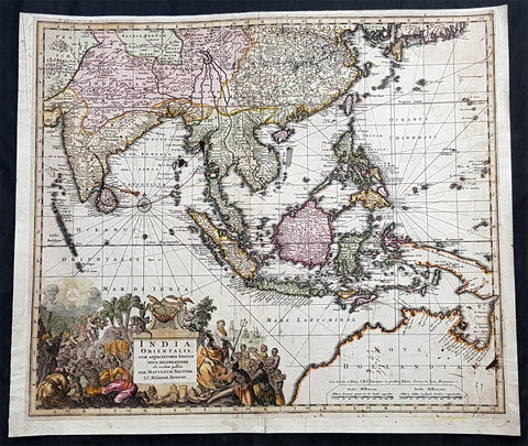
1730 Georg Seutter Large Antique Map Australia, China, SE Asia, Indonesia, India
- Title : India Orientalis cum Adjacentibus Insulis Nova Delineatione ob oculos posita..Matth. Seuttero
- Ref #: 93142
- Size: 24in x 20in (610mm x 510mm)
- Date : 1730
- Condition: (B) Good Condition
Description:
This large, beautifully hand coloured original antique map of the North & NW coastline of New Holland (Australia) East Asia, SE Asia, China, East Indies was published by Georg Mattraus Seutter in 1730.
The map is backed on 18th century contemporary paper and has old ink spots & lines but is overall a nice map and is priced accordingly.
General Definitions:
Paper thickness and quality: - Heavy and stable
Paper color : - off white
Age of map color: - Original
Colors used: - Yellow, green, blue, pink
General color appearance: - Authentic
Paper size: - 24in x 20in (610mm x 510mm)
Plate size: - 22 1/2in x 19in (565mm x 490mm)
Margins: - Min 1/2in (12mm)
Imperfections:
Margins: - Age toning, light soiling
Plate area: - Old ink marks & spots on map, light soiling, creasing
Verso: - Backed onto contemporary paper
Background:
The map extends from China, Japan and Persia in the North and in the south stretching from The Maldives east to Northern Australia. Of note, Australia continues to be attached to Nova Guinea, albeit with some hesitation, as the image extends outside the inner neat-line to convey this information - even though 20+ names are confidently engraved around Northern Australia Coastline.
The detail throughout Southeast Asia is informative and up-to-date and the print style typically strong.
The cartouche is one of Seutter\'s most ornate, with elaborate scenes from sea, land, jungle and mythology.
This map rarely appears on the market, as it was only included in select copies of Seutters atlas.
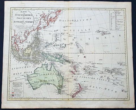
1795 (1806) Canzler Large Antique Map Australia, Ulimaroa, New Zealand SE Asia
- Title : Karte vom Funften Erdtheil oder Polynaesien-Inselwelt oder Australien oder Sudindien (Map of the fifth earth or Polynesia or Australia or South India.)
- Size: 24 1/4in x 20 1/2in (615mm x 520mm)
- Condition: (A+) Fine Condition
- Date : 1795 (1806)
- Ref #: 93121
Description:
This large original hand coloured copper-plate engraved, antique map of Australia, New Zealand and SE Asia by Friedrich Gottlieb Canzler in 1795, was published by the Homann Firm in 1806.
A distinct map with the short lived alternative name of Ulimaroa for New Holland, given by Canzler after Daniel Djurberg mistakenly interperated the New Zealand Maori word, Olhemaroa, from Cooks diary, for Australia. The real interpretation being Long Hand, the Maori name for New Caledonia.
There are two records in Cooks diary relating to Ulimaroa....
5th Feb 1769....This place we concluded to be the land difcovered by Tafman, which he called Cape Maria Van Diemen, and finding thefe people fo intelligent, we inquired farther, if they knew of any country befides their own: they anfwered, that they never had vifisted any other, but that their anceftors had told them, that to the N.W. by N., or N.N.W. there was a country of great extent, called Ulimaroa, which people had failed in a very large canoe
5th Feb 1770.....When we were under fail, our old man aTopaa came on board to take his leave of us, and as we were ftill defirous of making farther enquiries whether any memory of Tafman had been preferved among thefe people, Tupia was directed to afk him whether he had ever heard that fuch a veffel as ours had vifited the country. To this he replied in the negative, but faid, that his anceftors had told him there had once come to this place a fmall veffel, from a distant country, called Ulimaroa, in which were four men, who, upon coming on fhore, were all killed: upon being afked where this diftant land lay, he pointed to the northward. Of Ulimaroa we had heard fome-thing before, from people about the Bay of Iflands, who faid that their anceftors had vifisted it; and Tupia had alfo talked to us of Ulimaroa.
General Definitions:
Paper thickness and quality: - Heavy and stable
Paper color : - off white
Age of map color: - Original
Colors used: - Yellow, green, blue, pink
General color appearance: - Authentic
Paper size: - 24 1/4in x 20 1/2in (615mm x 520mm)
Plate size: - 24 1/2in x 19in (620mm x 490mm)
Margins: - Min 1in (25mm)
Imperfections:
Margins: - Light age toning
Plate area: - None
Verso: - None
Background:
Ulimaroa was a name given to Australia by the Swedish geographer and cartographer Daniel Djurberg in 1776. Djurberg adapted the name from Olhemaroa, a Māori word found in Hawkesworths edition of Captain James Cook and Sir Joseph Banks journals which is thought to have been a misunderstood translation — the Māori were actually referring to Grand Terre, the largest island of New Caledonia. Djurberg believed the name meant something like big red land, whereas modern linguists believe it meant long hand — echoing the geography of Grand Terre. The spurious name continued to be reproduced on certain European maps, particularly some Austrian, Czech, German and Swedish maps, until around 1820, including in Carl Almqvists 1817 novel Parjumouf Saga ifrån Nya Holland (Stockholm, 1817).
Canzler, Friedrich Gottlieb 1764-1811
Friedrich Gottlieb Canzler was born in Wolgast, Sweden in 1764. He graduated from the school in his hometown and from 1781 to 1783 the Sundische Gymnasium in Stralsund . He then studied history , geography , statistics and the Swedish language at the University of Göttingen . After completing his studies, he also received his doctorate and habilitation in Göttingen, and worked as a Privatdozent for history, geography, statistics and cameralistics .
In addition, he published in Göttingen from July 1789 to February 1791 the General Political State Newspaper for all Stands, for which he ran his own university and newspaper printing plant, and founded in 1797 an Academic Reading Museum. Two years later he was appointed Professor of Statistics, State Economics, Cameral, Financial and Commerz Sciences at the University of Greifswald where he worked until his death in 1811.
Selected Works:
- New magazine for recent history, Earth and ethnology. Leipzig 1790
- English language teaching for Germans. Göttingen 1796
- General Litteraturarchiv for history, geography and statistics. Leipzig 1792-1798 (as publisher)
- Map of the fifth earth or Polynesia or Australia or South India. Nuremberg 1795, 1805 and 1806 (as well as 1813 with corrections by Christian Gottlieb Reichard)
- Front India or Hindostan or East India on the side of the Ganges. Nuremberg 1804