Welcome to Classical Images!
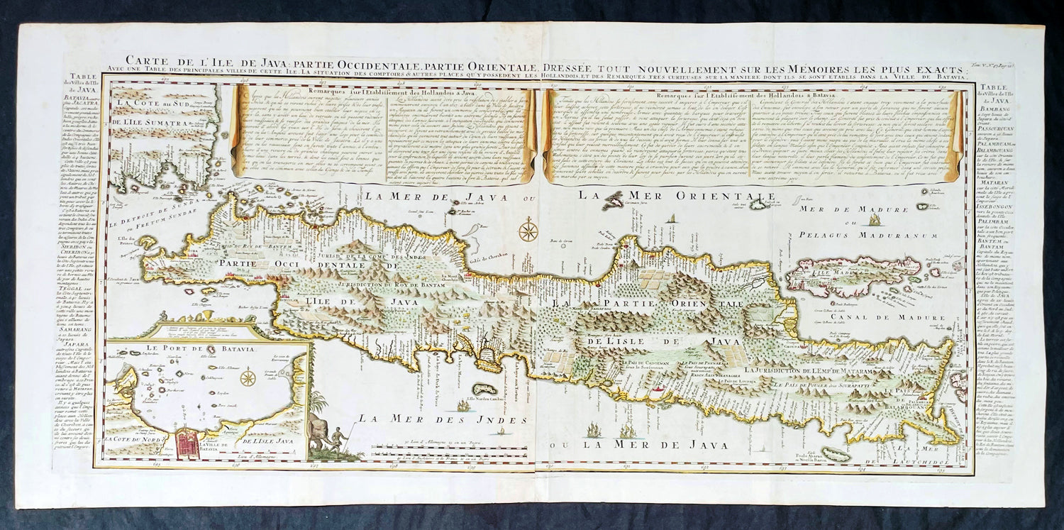
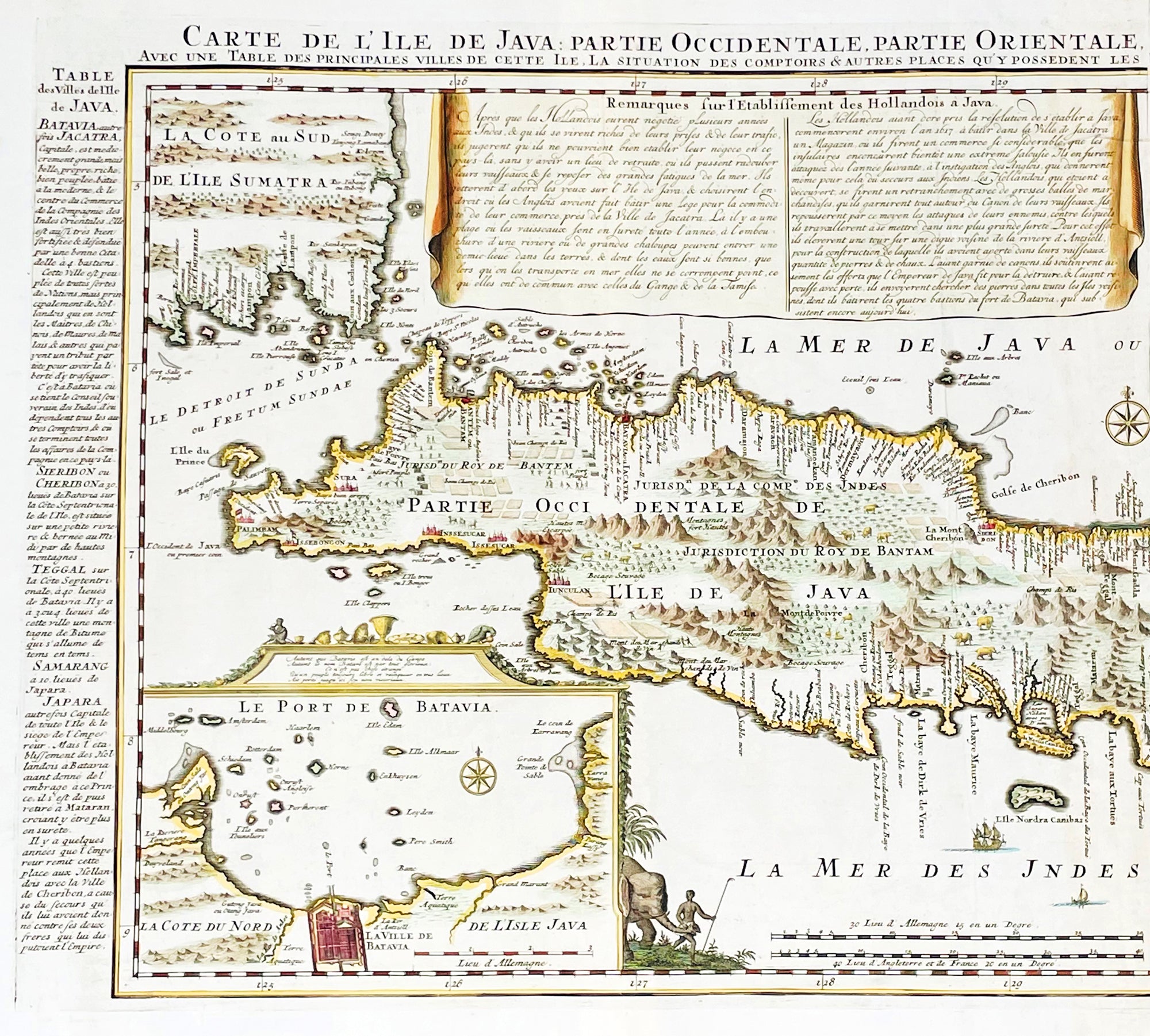
Description:This large fine beautifully hand coloured highly detailed original antique map of the Indonesian Island of Java was published by Henri Abraham Chatelain in 1718 was published in his famous Atlas Historique.This is a landmark map at a time when the Dutch East India Company still had stranglehold on the trade of the East Indies with bright hand colouring, clean strong sturdy paper and a heavy clear impression donating an early pressing.
General Definitions:Paper thickness and quality: - Heavy and stablePaper color : - off whiteAge of map color: - LaterColors used: - Green, red, orange, yellow, blueGeneral color appearance: - AuthenticPaper size: - 36 3/4in x 17 1/2in (980mm x 445mm)Plate size: - 34 1/2in x 15 1/2in (900mm x 395mm)Margins: - Min 1in (25mm)
Imperfections:Margins: - Folds as issuedPlate area: - Folds as issuedVerso: - Folds as issued
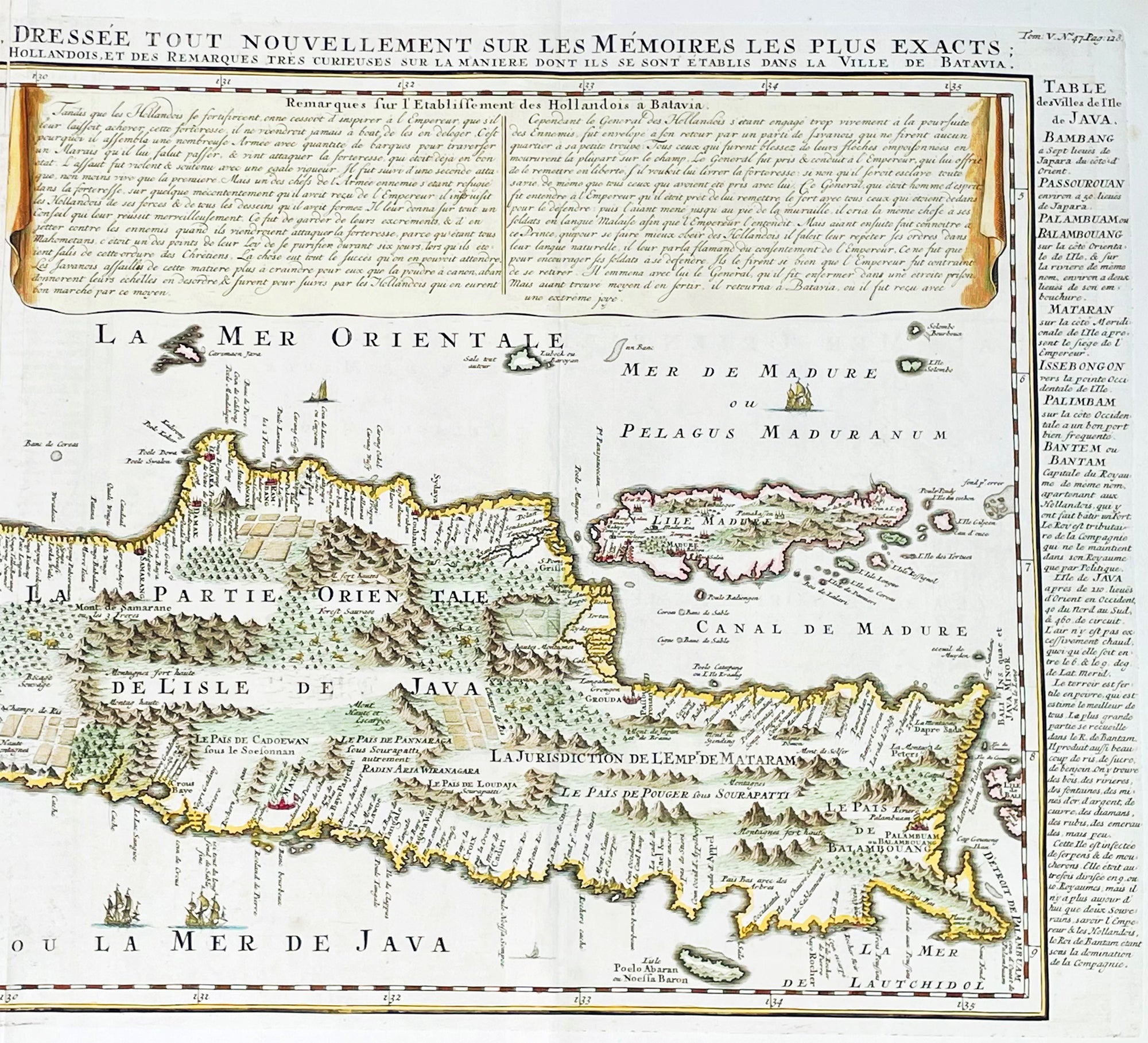
Background:A beautiful example of Henri Chatelain's important 1718 map of Java. Covers the island in full as well as adjacent parts of Sumatra and Bali. Offers beautiful engraving and extraordinary detail throughout, noting rice plantations, mountain ranges, grazing lands, forests, and in many places, elephants and gazelle. The previously unknown southern shore is mapped both correctly and in considerable detail. Also shows some offshore reefs and other dangers. The volcanic island of Krakatau, here identified as Cracatao, which nearly 150 years later would erupt with devastating consequences, appears in the Strait of Sunda between Java and Sumatra. In the lower left quadrant an inset details the city and port of Batavia, then the center of Dutch East Indian Company's activity in the region. Appearing in tapestry style windows at the top of the map is an area of extensive text. Composed by Gueudeville, this is a discussion of the history of the lands and countries depicted. Additional textual data referencing the cities and villages of Java, appears to the left and right of the map proper.In its day Chatelain's map of Java was by far the most sophisticated study of the island yet published. Previous to this map, the most advanced cartographic rendering of Java was Van der Aa's 1714 mapping of the region, which though it correctly identified general form of Java's northern shore, identified the southern shore as "Parte Incognita". Of course the Dutch were active in this region since the 17th century and had no doubt produced accurate manuscript charts of the island, but these were carefully guarded trade secrets controlled by the powerful Vereenigde Oostindische Compagnie (V.O.C. or Dutch East India Company). The publication of Chatelain's map of Java, offered here, suggests that Chatelain somehow obtained his data from a source outside of the V.O.C. That Chatelain's map was copied by Johannes Van Keulen II, the V.O.C.'s own cartographer, nine years later suggests that even the V.O.C., who maintained an active presence on the island, did not possess more accurate data. It is highly likely that Chatelain extracted much of his cartographic information on Java from Hadrien Reland, a Dutch scholar and philologist who composed a number of works on the Indonesian Archipelago in the early 18th century.A highly important map of the region and a must for an serious collection focusing on the East Indies.The Atlas Historique published by Henri Chatelain was part of a major work of its time, an encyclopedia in seven volumes, including geography as one of its main subjects. The text was by Nicholas Gueudeville and the maps by Chatelain. The Atlas included one of the finest map of America (four sheets) surrounded by vignettes and decorative insets. The Atlas Historique was completed between 1705 and 1720, further issues were published up to 1739. The series was published in Amsterdam, with Chatelain’s maps based on those of G. Delisle. (Koeman; M&B; Tooley; Burden; AMPR)