America (185)
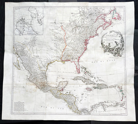
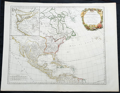
1746 J B D Anville Large Rare Antique Map of North America Pre French Indian War
-
Title : Amerique Septentrionale Publiee sous les Auspices de Monseigneur le Duc d Orleans.. Par Le Snr. D Anville MDCCXLVI
- Ref #: 17010
-
Condition: (A+) Fine Condition
- Size: 42 1/2in x 37in (1.08m x 940mm)
- Date : 1746
Description:
This large important original copper plate engraved antique map of North America, in 12 sheets joined, was engraved in 1746 - dated in the cartouche - and was published by Jean-Baptiste Bourguinon D Anville in his Elephant Folio Atlas Generale.
This map was instrumental in instructing the European Colonial powers of the time, England France & Spain the importance of dominating the New World, that ultimately led to the French and Indian War of 1754–63. This conflict determined the political direction of North America leading to the American War of Independence in 1775 and ultimately the formation of The United States of America.
To illustrate the importance of cartography in the mid eighteenth century, especially that of North America, a J B D Anville map is essential. D Anville dominated 18th century European cartography with many of his cartographical achievements, especially in North America, copied by many of his contemporaries such as Kitchen, Sayer, Homann, Seutter, Mitchell and others .
He was one of the first to leave blank spaces in his maps, where knowledge was scant or insufficient. His representation of the great lakes is superior to that of his contemporary John Mitchell, responsible for publishing one of the most famous mid 18th century maps of North America, A Map of the British and French Dominions in North America on 8 sheets in 1755 and remained the standard map of North America up until the end of the 18th century. (Ref: Tooley, Printed maps of America, 104; The Mapping of America 316)
General Definitions:
Paper thickness and quality: - Heavy and stable
Paper color : - off white
Age of map color: - Original
Colors used: - Red, yellow, green, blue
General color appearance: - Authentic
Paper size: - 42 1/2in x 37in (1.08m x 940mm)
Plate size: - 34 1/2in x 33 1/2in (875m x 850mm)
Margins: - Min 1in (25mm)
Imperfections:
Margins: - Small wormholes in left margin repaired, not affecting the image
Plate area: - Light age toning
Verso: - Age toning
Background:
The French and Indian War (1754–63) comprised the North American theatre of the worldwide Seven Years War of 1756–63. It pitted the colonies of British America against those of New France. Both sides were supported by military units from their parent countries, as well as by American Indian allies. At the start of the war, the French North American colonies had a population of roughly 60,000 settlers, compared with 2 million in the British North American colonies. The outnumbered French particularly depended on the Indians. The European nations declared war on one another in 1756 following months of localized conflict, escalating the war from a regional affair into an intercontinental conflict.
The name French and Indian War is used mainly in the United States. It refers to the two enemies of the British colonists, the royal French forces and their various American Indian allies. The British colonists were supported at various times by the Iroquois, Catawba, and Cherokee, and the French colonists were supported by Wabanaki Confederacy members Abenaki and Mikmaq, and Algonquin, Lenape, Ojibwa, Ottawa, Shawnee, and Wyandot.
British and other European historians use the term the Seven Years War, as do English-speaking Canadians. French Canadians call it La guerre de la Conquête (the War of the Conquest) or (rarely) the Fourth Intercolonial War.
Fighting took place primarily along the frontiers between New France and the British colonies, from Virginia in the south to Newfoundland in the north. It began with a dispute over control of the confluence of the Allegheny River and Monongahela River called the Forks of the Ohio, and the site of the French Fort Duquesne in Pittsburgh, Pennsylvania. The dispute erupted into violence in the Battle of Jumonville Glen in May 1754, during which Virginia militiamen under the command of 22-year-old George Washington ambushed a French patrol.
In 1755, six colonial governors in North America met with General Edward Braddock, the newly arrived British Army commander, and planned a four-way attack on the French. None succeeded, and the main effort by Braddock proved a disaster; he lost the Battle of the Monongahela on July 9, 1755 and died a few days later. British operations failed in the frontier areas of Pennsylvania and New York during 1755–57 due to a combination of poor management, internal divisions, effective Canadian scouts, French regular forces, and Indian warrior allies. In 1755, the British captured Fort Beauséjour on the border separating Nova Scotia from Acadia, and they ordered the expulsion of the Acadians (1755–64) soon afterwards. Orders for the deportation were given by William Shirley, Commander-in-Chief, North America, without direction from Great Britain. The Acadians were expelled, both those captured in arms and those who had sworn the loyalty oath to His Britannic Majesty. Indians likewise were driven off the land to make way for settlers from New England.
The British colonial government fell in the region of modern Nova Scotia after several disastrous campaigns in 1757, including a failed expedition against Louisbourg and the Siege of Fort William Henry; this last was followed by Indians torturing and massacring their British victims. William Pitt came to power and significantly increased British military resources in the colonies at a time when France was unwilling to risk large convoys to aid the limited forces that they had in New France, preferring to concentrate their forces against Prussia and its allies in the European theater of the war. Between 1758 and 1760, the British military launched a campaign to capture the Colony of Canada (part of New France). They succeeded in capturing territory in surrounding colonies and ultimately the city of Quebec (1759). The British later lost the Battle of Sainte-Foy west of Quebec (1760), but the French ceded Canada in accordance with the Treaty of Paris (1763).
The outcome was one of the most significant developments in a century of Anglo-French conflict. France ceded to Great Britain its territory east of the Mississippi. It ceded French Louisiana west of the Mississippi River (including New Orleans) to its ally Spain in compensation for Spains loss to Britain of Florida. (Spain had ceded Florida to Britain in exchange for the return of Havana, Cuba.) Frances colonial presence north of the Caribbean was reduced to the islands of Saint Pierre and Miquelon, confirming Great Britains position as the dominant colonial power in eastern North America.
Please note all items auctioned are genuine, we do not sell reproductions. A Certificate of Authenticity (COA) can be issued on request.
1692 Vincenzo Coronelli Large Original Antique Globe Gore Map of South America
-
Title : South America
- Ref #: 17007
-
Condition: (A+) Fine Condition
- Size: 19 1/2in x 12 1/4in (495mm x 310mm)
- Date : 1692
Description:
This large original antique copper plate engraved Globe Gore, a map of South America - from Vincenzo Coronellis original 42in Globe - was published by Vincenzo Maria Coronelli in the 1696 Venice edition of Isolario dell Atlante Veneto.
To my mind Coronellis maps are some of the most beautifully engraved maps of the 17th century and the epitome of these are his Globe Gores.
In 1696 Coronelli published all his globe gores - from the 2in to the 42 in Globes - in an atlas, Libero dei Globi, part of the great series of atlases, Isolario dell Atlante Veneto that was published by Coronelli to ensure his work was available to a wider audience, as very few could afford travel to Venice, Rome or Paris to view his completed globes.
General Definitions:
Paper thickness and quality: - Heavy and stable
Paper color : - off white
Age of map color: -
Colors used: -
General color appearance: -
Paper size: - 19 1/2in x 12 1/4in (495mm x 310mm)
Plate size: - 18in x 11in (455mm x 280mm)
Margins: - Min 1/2in (12mm)
Imperfections:
Margins: - None
Plate area: - None
Verso: - None
Background:
The original globe gores for the 42in Terrestrial & Celestial Globe were printed on 12 full length sheets - with two polar calottes - in 1688.
To help fit into Coronellis future publications of Atlante Veneto, Libro dei Globi and Isolario dell Atlante Veneto the gore sheets were re-issued as the same size but cut into smaller sections. This effectively allowed the gores to be published in their original size but instead of one sheet per gore there were 2, 4 or 6 sheets making up the one gore.
The first edition of Coronellis 3 ½-foot celestial globe was engraved by Nolin in Paris after drawings provided by the Italian geographer and was printed in 1688. At the same time, its terrestrial counterpart was engraved and printed in Venice under Coronellis direction. These globes were produced in part as replicas of the gigantic and unique 15 foot-diameter pair of globes that Coronelli constructed and presented to Louis XIV, the King of France, in 1683, and which secured his fame as Europes premier globe maker. In 1693, soon after Coronelli engraved and printed the first Venetian edition of the 3 ½-foot celestial globe, Nolin engraved at Paris an entirely new edition on new plates. This globe was based on Coronellis work, but with the main legends in Latin, not Italian, as befitted a French market. The 3 ½ foot celestial globe was one of the crowning glories of Coronellis output and was also the grandest celestial globe of the 17th century.
(Ref: Shirley; Armao, Ermanno. Vincenzo Coronelli Cenni sulluomo e la sua Vita Catalogo... Bibliopolis, Florence pp.130-134)
Please note all items auctioned are genuine, we do not sell reproductions. A Certificate of Authenticity (COA) can be issued on request.
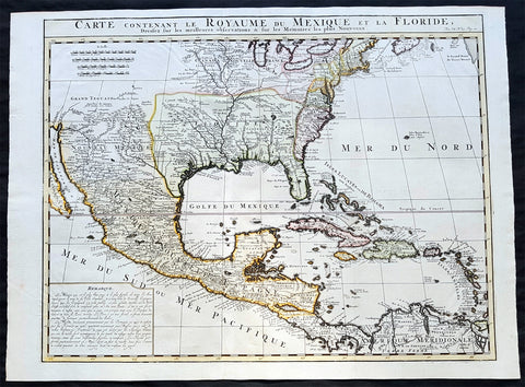
1719 Chatelain Antique Map of North America, GOM, Caribbean, United States
- Title : Carte Contenant Le Royaume Du Mexique Et La Floride
- Date : 1719
- Condition: (A+) Fine Condition
- Ref: 50621
- Size: 23 1/4in x 17 1/2in (590m x 445m)
Description:
This large beautifully hand coloured original antique foundation map of North America and the Caribbean - after Delisle landmark map of 1703 - was published by Henri Abraham Chatelain in 1719, in his famous Atlas Historique.
Background:
A very attractive example of Chatelain's issue of Guillaume De L'Isle's foundation map of present-day United States, Central America and the West Indies, originally published in 1703. Guillaume De L'Isle brought a new scientific approach to mapmaking at the end of the seventeenth century and his rigorously prepared maps of all areas became the standards for much of the following century.
Amongst his most important works were those relating to the New World, especially North America, where the recent reports of French travellers into the interior were utilised. Sources for this map - the first to show the lower reaches of the Mississippi accurately - included d'Iberville, Tonty and Le Sueur, Father Gravier, and Bienville (later to become Governor of the French colony of Louisiana). Evidence of the contemporary superiority of De L'Isle's maps lies in the numerous copies, published in Paris, Amsterdam, London and Germany, and the republishing of the original plate over many years. Geographically his maps were as correct, however, this map is also remarkable for De L'Isle's political boundaries which squeeze the English Colonies, on the east coast into a narrow strip, thus allocating the greater part of North America to France. Chatelain's map has a large panel of text describing Mexico and Florida at lower left.
General Description:
Paper thickness and quality: - Heavy and stable
Paper color: - White
Age of map color: - Early
Colors used: - Pink, green, yellow, blue
General color appearance: - Authentic
Paper size: - 23 1/4in x 17 1/2in (590m x 445m)
Plate size: - 20 3/4in x 16 1/4in (530m x 415mm)
Margins: - min. 1/2in (12mm)
Imperfections: Margins: - None
Plate area: - Folds as issued
Verso: - None
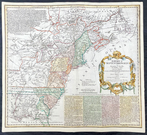
1756 Homann Antique Map Colonial United States North America French Indian War
- Title : America Septentrionalis a domino d Anville in Galiis edita nunc in Anglia coloniis in interiorem Virginiam deductis nec non fluvii Ohio cursu aucta notisq geographicis et historicis illustrata.....1756
- Ref #: 17001
- Size: 21in x 19in (535mm x 480mm)
- Date : 1756
- Condition: (A) Very Good Condition
Description:
This original hand coloured copper-plate engraved antique 1st edition map of the Colonial United States, at the beginning of the French-Indian war, was engraved in 1756 - dated in cartouche - by the Homann firm, Germany.
First edition Homann map of the English Colonies in North America prior to the start of the French and Indian War. The map stretches just west of the Mississippi River to the east and from James Bay through the Great Lakes to the Gulf of Mexico. Although most of the text is in German, there is also much in English, including numerous place named annotations associated the French and Indian War, such as the locations of Fort Duquesne and Fort Necessity, both taken by the French in 1754. Thus although the cartographer credits D Anville for the basic cartography, it is clear he is drawing from English, not French, sources. Bottom right and upper left are notes offering the history of North America.
General Definitions:
Paper thickness and quality: - Heavy and stable
Paper color : - off white
Age of map color: - Original & later
Colors used: - Yellow, green, blue, pink
General color appearance: - Authentic
Paper size: - 21in x 19in (535mm x 480mm)
Plate size: - 21in x 19in (535mm x 480mm)
Margins: - Min 1/2in (12mm)
Imperfections:
Margins: - All margins extended from border
Plate area: - Light crease adjacent to centerfold, soiling in top right border
Verso: - Light soiling.
Background:
The French and Indian War (1754–63) comprised the North American theatre of the worldwide Seven Years War of 1756–63. It pitted the colonies of British America against those of New France. Both sides were supported by military units from their parent countries, as well as by American Indian allies. At the start of the war, the French North American colonies had a population of roughly 60,000 settlers, compared with 2 million in the British North American colonies. The outnumbered French particularly depended on the Indians. The European nations declared war on one another in 1756 following months of localized conflict, escalating the war from a regional affair into an intercontinental conflict.
The name French and Indian War is used mainly in the United States. It refers to the two enemies of the British colonists, the royal French forces and their various American Indian allies. The British colonists were supported at various times by the Iroquois, Catawba, and Cherokee, and the French colonists were supported by Wabanaki Confederacy members Abenaki and Mikmaq, and Algonquin, Lenape, Ojibwa, Ottawa, Shawnee, and Wyandot.
British and other European historians use the term the Seven Years War, as do English-speaking Canadians. French Canadians call it La guerre de la Conquête (the War of the Conquest) or (rarely) the Fourth Intercolonial War.
Fighting took place primarily along the frontiers between New France and the British colonies, from Virginia in the south to Newfoundland in the north. It began with a dispute over control of the confluence of the Allegheny River and Monongahela River called the Forks of the Ohio, and the site of the French Fort Duquesne in Pittsburgh, Pennsylvania. The dispute erupted into violence in the Battle of Jumonville Glen in May 1754, during which Virginia militiamen under the command of 22-year-old George Washington ambushed a French patrol.
In 1755, six colonial governors in North America met with General Edward Braddock, the newly arrived British Army commander, and planned a four-way attack on the French. None succeeded, and the main effort by Braddock proved a disaster; he lost the Battle of the Monongahela on July 9, 1755 and died a few days later. British operations failed in the frontier areas of Pennsylvania and New York during 1755–57 due to a combination of poor management, internal divisions, effective Canadian scouts, French regular forces, and Indian warrior allies. In 1755, the British captured Fort Beauséjour on the border separating Nova Scotia from Acadia, and they ordered the expulsion of the Acadians (1755–64) soon afterwards. Orders for the deportation were given by William Shirley, Commander-in-Chief, North America, without direction from Great Britain. The Acadians were expelled, both those captured in arms and those who had sworn the loyalty oath to His Britannic Majesty. Indians likewise were driven off the land to make way for settlers from New England.
The British colonial government fell in the region of modern Nova Scotia after several disastrous campaigns in 1757, including a failed expedition against Louisbourg and the Siege of Fort William Henry; this last was followed by Indians torturing and massacring their British victims. William Pitt came to power and significantly increased British military resources in the colonies at a time when France was unwilling to risk large convoys to aid the limited forces that they had in New France, preferring to concentrate their forces against Prussia and its allies in the European theater of the war. Between 1758 and 1760, the British military launched a campaign to capture the Colony of Canada (part of New France). They succeeded in capturing territory in surrounding colonies and ultimately the city of Quebec (1759). The British later lost the Battle of Sainte-Foy west of Quebec (1760), but the French ceded Canada in accordance with the Treaty of Paris (1763).
The outcome was one of the most significant developments in a century of Anglo-French conflict. France ceded to Great Britain its territory east of the Mississippi. It ceded French Louisiana west of the Mississippi River (including New Orleans) to its ally Spain in compensation for Spains loss to Britain of Florida. (Spain had ceded Florida to Britain in exchange for the return of Havana, Cuba.) Frances colonial presence north of the Caribbean was reduced to the islands of Saint Pierre and Miquelon, confirming Great Britains position as the dominant colonial power in eastern North America.
Please note all items auctioned are genuine, we do not sell reproductions. A Certificate of Authenticity (COA) can be issued on request.
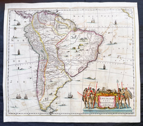
1639 Henricus Hondius Large Antique Map of South America - Beautiful
- Title : Americae Pars Meridionalis Henrici Hony...
- Ref #: 43162
-
Condition: (A) Very Good Condition
- Size: 22 1/2in x 20in (570mm x 510mm)
- Date : 1639
Description:
This beautifully hand coloured original antique copper plate engraved antique map of South America by Henricus Hondius was published in the 1639 French edition of Mercators Atlas by Jan Jansson and Henricus Hondius.
Beautiful large map, the second by Hondius, with original hand colouring and strong sturdy paper.
General Definitions:
Paper thickness and quality: - Heavy and stable
Paper color : - off white
Age of map color: - Original
Colors used: - Yellow, green, blue, pink
General color appearance: - Authentic
Paper size: - 22 1/2in x 20in (570mm x 510mm)
Plate size: - 21 1/2in x 18 1/4in (545mm x 460mm)
Margins: - Min 1/2in (12mm)
Imperfections:
Margins: - Top margin extended from plate-mark, small repair to bottom margin
Plate area: - Offsetting
Verso: - Bottom centerfold re-joined, no loss
Background:
Between 1452 and 1493, a series of papal bulls (Dum Diversas, Romanus Pontifex, and Inter caetera) paved the way for the European colonization and Catholic missions in the New World. These authorized the European Christian nations to \"take possession\" of non-Christian lands and encouraged subduing and converting the non-Christian people of Africa and the Americas.
In 1494, Portugal and Spain, the two great maritime powers of that time, signed the Treaty of Tordesillas in the expectation of new lands being discovered in the west. Through the treaty they agreed that all the land outside Europe should be an exclusive duopoly between the two countries. The treaty established an imaginary line along a north-south meridian 370 leagues west of Cape Verde Islands, roughly 46° 37\' W. In terms of the treaty, all land to the west of the line (which is now known to include most of the South American soil), would belong to Spain, and all land to the east, to Portugal. Because accurate measurements of longitude were not possible at that time, the line was not strictly enforced, resulting in a Portuguese expansion of Brazil across the meridian.
In 1498, during his third voyage to the Americas, Christopher Columbus sailed near the Orinoco Delta and then landed in the Gulf of Paria (Actual Venezuela). Amazed by the great offshore current of freshwater which deflected his course eastward, Columbus expressed in his moving letter to Isabella I and Ferdinand II that he must have reached heaven on Earth (terrestrial paradise):
Great signs are these of the Terrestrial Paradise, for the site conforms to the opinion of the holy and wise theologians whom I have mentioned. And likewise, the [other] signs conform very well, for I have never read or heard of such a large quantity of fresh water being inside and in such close proximity to salt water; the very mild temperateness also corroborates this; and if the water of which I speak does not proceed from Paradise then it is an even greater marvel, because I do not believe such a large and deep river has ever been known to exist in this world.
Beginning in 1499, the people and natural resources of South America were repeatedly exploited by foreign conquistadors, first from Spain and later from Portugal. These competing colonial nations claimed the land and resources as their own and divided it into colonies.
European diseases (smallpox, influenza, measles and typhus) to which the native populations had no resistance were the overwhelming cause of the depopulation of the Native American population. Cruel systems of forced labor (such as encomiendas and mining industry\'s mita) under Spanish control also contributed to depopulation. Lower bound estimates speak of a decline in the population of around 20–50 per cent, whereas high estimates arrive at 90 per cent.[42] Following this, African slaves, who had developed immunity to these diseases, were quickly brought in to replace them.
The Spaniards were committed to converting their American subjects to Christianity and were quick to purge any native cultural practices that hindered this end. However, most initial attempts at this were only partially successful; American groups simply blended Catholicism with their traditional beliefs. The Spaniards did not impose their language to the degree they did their religion. In fact, the missionary work of the Roman Catholic Church in Quechua, Nahuatl, and Guarani actually contributed to the expansion of these American languages, equipping them with writing systems.
Eventually the natives and the Spaniards interbred, forming a Mestizo class. Mestizos and the Native Americans were often forced to pay unfair taxes to the Spanish government (although all subjects paid taxes) and were punished harshly for disobeying their laws. Many native artworks were considered pagan idols and destroyed by Spanish explorers. This included a great number of gold and silver sculptures, which were melted down before transport to Europe.
In 1616, the Dutch, attracted by the legend of El Dorado, founded a fort in Guayana and established three colonies: Demerara, Berbice, and Essequibo.
In 1624 France attempted to settle in the area of modern-day French Guiana, but was forced to abandon it in the face of hostility from the Portuguese, who viewed it as a violation of the Treaty of Tordesillas. However French settlers returned in 1630 and in 1643 managed to establish a settlement at Cayenne along with some small-scale plantations.
Since the sixteenth century there were some movements of discontent to Spanish and Portuguese colonial system. Among these movements, the most famous being that of the Maroons, slaves who escaped their masters and in the shelter of the forest communities organized free communities. Attempts to subject them by the royal army was unsuccessful, because the Maroons had learned to master the South American jungles. In a royal decree of 1713, the king gave legality to the first free population of the continent: Palenque de San Basilio in Colombia today, led by Benkos Bioho. Brazil saw the formation of a genuine African kingdom on their soil, with the Quilombo of Palmares.
Between 1721 and 1735, the Revolt of the Comuneros of Paraguay arose, because of clashes between the Paraguayan settlers and the Jesuits, who ran the large and prosperous Jesuit Reductions and controlled a large number of Christianized Indians.
Between 1742 and 1756, was the insurrection of Juan Santos Atahualpa in the central jungle of Peru. In 1780, the Viceroyalty of Peru was met with the insurrection of curaca Condorcanqui or Tupac Amaru II, which would be continued by Tupac Catari in Upper Peru.
In 1763, the African Cuffy led a revolt in Guyana which was bloodily suppressed by the Dutch. In 1781, the Revolt of the Comuneros (New Granada), an insurrection of the villagers in the Viceroyalty of New Granada, was a popular revolution that united indigenous people and mestizos. The villagers tried to be the colonial power and despite the capitulation were signed, the Viceroy Manuel Antonio Flores did not comply, and instead ran to the main leaders José Antonio Galán. In 1796, Essequibo (colony) of the Dutch was taken by the British, who had previously begun a massive introduction of slaves.
During the eighteenth century, the figure of the priest, mathematician and botanist José Celestino Mutis (1732–1808), was delegated by the Viceroy Antonio Caballero y Gongora to conduct an inventory of the nature of the Nueva Granada, which became known as the Botanical Expedition, which classified plants, wildlife and founded the first astronomical observatory in the city of Santa Fé de Bogotá.
On August 15, 1801, the Prussian scientist Alexander von Humboldt reached Fontibón where Mutis, and began his expedition to New Granada, Quito. The meeting between the two scholars are considered the brightest spot of the botanical expedition. Humboldt also visited Venezuela, Mexico, United States, Chile, and Peru. Through his observations of temperature differences between the Pacific Ocean between Chile and Peru in different periods of the year, he discovered cold currents moving from south to north up the coast of Peru, which was named the Humboldt Current in his honour.
Between 1806 and 1807, British military forces tried to invade the area of the Rio de la Plata, at the command of Home Riggs Popham and William Carr Beresford, and John Whitelocke. The invasions were repelled, but powerfully affected the Spanish authority
Please note all items auctioned are genuine, we do not sell reproductions. A Certificate of Authenticity (COA) can be issued on request.
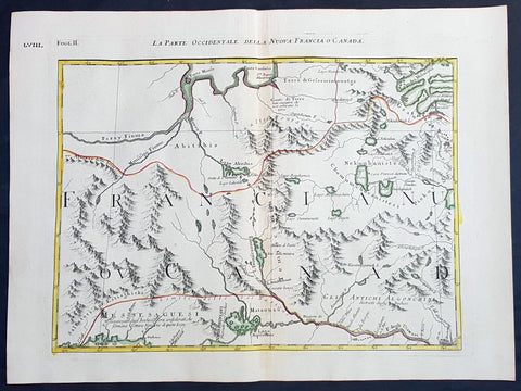
1778 Antonio Zatta & John Mitchell Antique Map of East Quebec & Western Ontario
- Title : La Parte Occidentale Della Nuova Francia o Canada
- Date : 1778
- Condition: (A+) Fine Condition
- Ref: 93512
- Size: 21in x 15 1/2in (535mm x 395mm)
Description:
Description:
This wonderfully executed original copper plate engraved hand coloured antique map of eastern Quebec and Western Ontario - from Lake Superior in the west to Montreal in the east and Hudson Bay in the North was published as Sheet 2, of 12, of Antonio Zattas 1778 re-issue of John Mitchells famous landmark map A Map of the British and French Dominions in North America, With the Roads, Distances, Limits, and Extent of the Settlements was published in Zattas Atlas Atlante Novissimo (1779-1785)
I have included an image of the complete 12 sheet joined map by Zatta as well as an image of Mitchells map.
General Definitions:
Paper thickness and quality: - Heavy and stable
Paper color : - off white
Age of map color: - Original
Colors used: - Yellow, green, blue, pink
General color appearance: - Authentic
Paper size: - 21in x 15 1/2in (535mm x 395mm)
Plate size: - 17 1/2in x 13 1/2in (445mm x 345mm)
Margins: - Min 1in (25mm)
Imperfections:
Margins: - None
Plate area: - None
Verso: - None
Background:
The Mitchell Map by John Mitchell (1711–1768) is considered the most famous map of North America both cartographically and historically, was reprinted several times during the second half of the 18th century. The Mitchell Map was used as a primary map source during the Treaty of Paris for defining the boundaries of the newly independent United States. The map remained important for resolving border disputes between the United States and Canada as recently as the 1980s dispute over the Gulf of Maine fisheries. The Mitchell Map is the most comprehensive map of eastern North America made during the colonial era. Its size is about 6.5 feet (2.0 m) wide by 4.5 feet (1.4 m) high.
John Mitchell was not a professional geographer or map-maker. Son of a wealthy Virginian family in Lancaster County, on Virginia's Northern Neck, he had been educated at Edinburgh University, Scotland; this education included the first two years of the three-year medical program. Returning to coastal Virginia, he practiced as a physician and studied the local botany. Ill health forced Mitchell and his wife to leave Virginia for London in 1746. There, he served as a consultant on exotic plants to noblemen interested in gardens. Also, it was there that Mitchell would make his famous map. Map historians have understandably been interested in why a physician and botanist who had shown no previous interest in map making should make such a large and detailed map.
Until recently, historians have argued that Mitchell was upset by the lack of interest shown by politicians in London about colonial affairs and so set out to warn them about the dangers posed to the British colonies by the French. Mitchell did so, on his own initiative, by making a first map of North America in 1750, which he then showed to the politicians he knew through his botanical and gardening activities. The map so impressed George Montagu-Dunk, 2nd Earl of Halifax, appointed president of the Board of Trade and Plantations in 1748, that Halifax opened up the official archives and solicited new maps from the colonies for Mitchell to make a new and better map. This was the map published in 1755. That is, the motive force for preparations against the French threat is understood to have come from a colonist who sought to take control of the colonies' future on behalf of the other colonists.
A re-examination of the archival evidence indicates, however, that Mitchell made his first map in 1750 at Halifax's behest. Halifax became president of the Board of Trade directly after the conclusion of the War of the Austrian Succession (1744–1748) and its North American component, King George's War. The war had ended in stalemate and a return to the Anglo-French status quo of the 1714 Treaty of Utrecht. In fact, it was a common conviction that it was only a matter of time before another global Anglo-French war would begin, and it was commonly expected that the spark of the new conflict would be the North American colonies. It was then that Halifax latched onto Mitchell as an expert informant on all things colonial; one of his requests, apparently, was for Mitchell to make a new map to show the territorial situation in North America. Certainly, it was only after 1749 that Mitchell's correspondence revealed his new interests in both geography and politics.
Mitchell compiled a first map in 1750 from the materials that he could find in London, in official archives and private hands. It proved to be inadequate. Halifax accordingly ordered the governors of the British colonies to send new maps, which most did. These became the basis, when fitted into the overall geographical frame provided by the maps of the French geographer Guillaume Delisle. Late in 1754, Halifax was using one manuscript copy of Mitchell's second map to successfully promote his political position (no compromise with the French) within the British cabinet in the build-up to the Seven Years' War aka French and Indian War. Halifax also permitted Mitchell to have the map published: it appeared in April 1755, engraved by Thomas Kitchin and published by Andrew Millar.
The published map bore the title A Map of the British and French Dominions in North America. It bore the copyright date of 13 February 1755, but the map was probably not sold to the public until April or even May. Minor corrections to the map's printing plates were made probably during the printing process.
The geographer John Green (né Braddock Mead) criticized Mitchell and his map soon after it appeared, emphasizing two failings with respect to Nova Scotia (an area of particular dispute with the French). Mitchell, Green noted, had used neither the astronomical observations for latitude and longitude made by Marquis Joseph Bernard de Chabert in the 1740s nor a 1715 chart of the Nova Scotia coast. In response, Mitchell released a new version of his map, now with two large blocks of text that described all of his data sources; the new version of the map also adjusted the coastline in line with Chabert's work but rejected the 1715 chart as deeply flawed. This version of the map, which Mitchell referred to as the "second edition," is commonly thought to have appeared sometime in 1757, but advertisements in the (London) Public Advertiser and Gazetteer and London Daily Advertiser on 23 April 1756 clearly indicate that this new map appeared at that time.
The map continued to be corrected and some boundaries updated, even after Mitchell's death in 1768.
Mitchell's map was printed in eight sheets; when assembled, it measures 136 cm by 195 cm (4 feet 6 inches by 6 feet 5 inches; height x width). The initial impressions printed in 1755 have a consistent coloring outlining British colonial claims. Mitchell extended the southern colonies across the entire continent, even over established Spanish territory west of the Mississippi. Mitchell divided up the Iroquois territories (as he understood them, reaching from Lake Champlain [Lac Irocoisia] to the Mississippi, and north of Lake Superior) between Virginia and New York, leaving only a much-reduced territory to the French.
Mitchell's map was expensive but it spawned many cheaper variants that trumpeted Halifax and Mitchell's powerful colonial vision to the British public. One of these, published in December 1755 by "a Society of Anti-Gallicans", restricted the French even further just to Quebec.
The map is liberally sprinkled with text describing and explaining various features, especially in regions that were relatively unknown or which were subject to political dispute. Many notes describe the natural resources and potential for settlement of frontier regions. Others describe Indian tribes. Many Indian settlements are shown, along with important Indian trails.
Since Mitchell's main objective was to show the French threat to the British colonies, there is a very strong pro-British bias in the map, especially with regard to the Iroquois. The map makes clear that the Iroquois were not just allies of Britain, but subjects, and that all Iroquois land was therefore British territory. Huge parts of the continent are noted as being British due to Iroquois conquest of one tribe or another. French activity within the Iroquois claimed lands is noted, explicitly or implicitly, as illegal.
In cases where the imperial claims of Britain and France were questionable, Mitchell always takes the British side. Thus many of his notes and boundaries seem like political propaganda today. Some of the claims seem to be outright falsehoods.
The map is very large and the notes are often very small, making it difficult to view online. Reduced scale copies result in unreadable notes. The following list gives a few examples of the kind of notes found on the map, with Mitchell's spelling:
- The region of today's central Tennessee and Kentucky (between the Tennessee and Cumberland Rivers): A Fine Level Fertile Country of great Extent, by Accounts of the Indians and our People
- In the area between the Mississippi River and the Tennessee River: This Country of the Cherokees which extends Westward to the Mississippi and Northward to the Confines of the Six Nations was formally surrendered to the Crown of Britain at Westminster 1729
- In the Great Plains: The Nadouessoians are reckoned one of the most Populous Nations of Indians in North America, altho' the number and situation of their Villages are not known nor laid down. (Reference to the Sioux)
- Along the coast of the Gulf of Mexico, present-day Texas: Wandering Savage Indians
- Southwest of Hudson Bay: The long and Barbarous Names lately given to some of these Northern Parts of Canada and the Lakes we have not inserted, as they are of no use, and uncertain Authority.
- North of Lake Huron: MESSESAGUES—Subdued by the Iroquois and now united with them making the 8th Nation in that League. (reference to the Mississaugas)
- Missouri River: Missouri River is reckoned to run Westward to the Mountains of New Mexico, as far as the Ohio does Eastward
- Present-day Iowa: Extensive Meadows full of Buffaloes
- Sandusky, Ohio: Sandoski—Canahogue—The seat of War, the Mart of Trade, & chief Hunting Grounds of the Six Nations, on the Lakes & the Ohio.
- Central Pennsylvania, north of present-day Harrisburg: St. Anthony's Wilderness
- Illinois region: The Antient Eriez were extirpated by the Iroquois upwards of 100 years ago, ever since which time they have been in Possession of L. Erie (reference to the Erie people)
- Along Illinois River and overland to the south end of Lake Michigan: Western Bounds of the Six Nations sold and Surrendered to Great Britain
- Illinois region: The Six Nations have extended their Territories to the River Illinois, ever since the Year 1672, when they subdued, and were incorporated with, the Antient Chaouanons, the Native Proprietors of these Countries, and the River Ohio. Besides which they likewise claim a Right of Conquest over the Illinois, and all the Mississippi as far as they extend. This is confirmed by their own Claims and Possessions in 1742, which include all the Bounds here laid down, and none have ever thought fit to dispute them. (reference to the Illiniwek)
- Just below the previous note: The Ohio Indians are a mixt Tribe of the Several Indians of our Colonies, settled here under the Six Nations, who have always been in Alliance and Subjection to the English. The most numerous of them are the Delaware and Shawnoes, who are Natives of Delaware River. Those about Philadelphia were called Sauwanoos whom we now call Shawanoes, or Shawnoes. The Mohickans and Minquaas were the Antient Inhabitants of Susquehanna R. (reference to the Lenape, Shawnee, and Susquehannock Indians)
- Southeast Missouri area: Mines of Marameg, which gave rise to the famous Mississippi Scheme 1719.
- North Florida: TIMOOQUA—Destroy'd by the Carolinians in 1706 (reference to the Timucua)
- South Georgia: COUNTRY OF THE APALACHEES—Conquered & surrendered to the Carolinians, after two memorable Victories obtain'd over them & the Spaniards in 1702 & 1703 at the Places marked thus [crossed-swords] (reference to the Apalachee)
- Alabama area: The English have Factories & Settlements in all the Towns of the Creek Indians of any note, except Albamas; which was usurped by the French in 1715 but established by the English 28 years before. (reference to the Creek people)
- Yazoo River: River of the Yasous—The Indians on this River were in Alliance with the English, for which they have been destroyed by the French (reference to the Yazoo tribe)
- Many geographic features are labeled with names no longer in use or oddly spelled, including:
Des Moines River: Moingona River
Kanawha and New River together: Gr. Conhaway called Wood R. or New R.
Kentucky River: Cuttawa or Catawba R.
Clinch River: Pelisipi River (a tributary is labeled Clinch's R.)
Tennessee River: River of the Cherakees, or Hogohegee R. Upstream another label says River Hogohegee or Callamaco
French Broad River: Agiqua R.
Little Tennessee River: Tannaſsee or Satico R.
Hiwassee River: Euphasee
Ohio River: Ohio or Splawacipiki R.
Altamaha River: Alatamaha or George R.
Minnesota River: Ouadebameniſsouté or R. St. Peter (reflecting the Dakota name Watpá Mnísota and the French name Rivière de St. Pierre)
Muskegon River: Maticon R.
The map also included non-existent features, such as Isle Phelipeaux in Lake Superior, found in earlier maps by Jacques-Nicolas Bellin.
The Mitchell Map remained the most detailed map of North America available in the later eighteenth century. Various impressions (and also French copies) were used to establish the boundaries of the new United States of America by diplomats at the 1783 Treaty of Paris that ended the American Revolutionary War. The map's inaccuracies subsequently led to a number of border disputes, such as in Maine. Its supposition that the Mississippi River extended north to the 50th parallel (into British territory) resulted in the treaty using it as a landmark for a geographically impossible definition of the border in that region. It was not until 1842, when the Webster-Ashburton Treaty resolved these inconsistencies with fixes such as the one that created Minnesota's Northwest Angle, that the U.S.–Canada border was clearly drawn from Maine to the Oregon Country.
Similarly, during the drafting of the Northwest Ordinance, the map's inaccuracy in depicting where an east–west line drawn through the southernmost point of Lake Michigan would intersect Lake Erie led to a long dispute over the Ohio–Michigan border that culminated in the Toledo War.
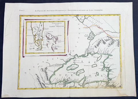
1778 Antonio Zatta & John Mitchell Antique Map of Lake Superior & Florida
- Title : Il Paese de Selvaggi Outauace si e Kilistinesi Intorno Al Lago Superiore; Supplemento alla Florida Orientale
- Date : 1778
- Condition: (A+) Fine Condition
- Ref: 93517
- Size: 21in x 15 1/2in (535mm x 395mm)
Description:
This wonderfully executed original copper plate engraved hand coloured antique map of Lake Superior, with an inset map of southern Florida, was published as Sheet 1, of 12, of Antonio Zattas 1778 re-issue of John Mitchells famous landmark map A Map of the British and French Dominions in North America, With the Roads, Distances, Limits, and Extent of the Settlements was published in Zattas Atlas Atlante Novissimo (1779-1785)
I have included an image of the complete 12 sheet joined map by Zatta as well as an image of Mitchells map.
General Definitions:
Paper thickness and quality: - Heavy and stable
Paper color : - off white
Age of map color: - Original
Colors used: - Yellow, green, blue, pink
General color appearance: - Authentic
Paper size: - 21in x 15 1/2in (535mm x 395mm)
Plate size: - 17 1/2in x 13 1/2in (445mm x 345mm)
Margins: - Min 1in (25mm)
Imperfections:
Margins: - None
Plate area: - None
Verso: - None
Background:
The Mitchell Map by John Mitchell (1711–1768) is considered the most famous map of North America both cartographically and historically, was reprinted several times during the second half of the 18th century. The Mitchell Map was used as a primary map source during the Treaty of Paris for defining the boundaries of the newly independent United States. The map remained important for resolving border disputes between the United States and Canada as recently as the 1980s dispute over the Gulf of Maine fisheries. The Mitchell Map is the most comprehensive map of eastern North America made during the colonial era. Its size is about 6.5 feet (2.0 m) wide by 4.5 feet (1.4 m) high.
John Mitchell was not a professional geographer or map-maker. Son of a wealthy Virginian family in Lancaster County, on Virginia's Northern Neck, he had been educated at Edinburgh University, Scotland; this education included the first two years of the three-year medical program. Returning to coastal Virginia, he practiced as a physician and studied the local botany. Ill health forced Mitchell and his wife to leave Virginia for London in 1746. There, he served as a consultant on exotic plants to noblemen interested in gardens. Also, it was there that Mitchell would make his famous map. Map historians have understandably been interested in why a physician and botanist who had shown no previous interest in map making should make such a large and detailed map.
Until recently, historians have argued that Mitchell was upset by the lack of interest shown by politicians in London about colonial affairs and so set out to warn them about the dangers posed to the British colonies by the French. Mitchell did so, on his own initiative, by making a first map of North America in 1750, which he then showed to the politicians he knew through his botanical and gardening activities. The map so impressed George Montagu-Dunk, 2nd Earl of Halifax, appointed president of the Board of Trade and Plantations in 1748, that Halifax opened up the official archives and solicited new maps from the colonies for Mitchell to make a new and better map. This was the map published in 1755. That is, the motive force for preparations against the French threat is understood to have come from a colonist who sought to take control of the colonies' future on behalf of the other colonists.
A re-examination of the archival evidence indicates, however, that Mitchell made his first map in 1750 at Halifax's behest. Halifax became president of the Board of Trade directly after the conclusion of the War of the Austrian Succession (1744–1748) and its North American component, King George's War. The war had ended in stalemate and a return to the Anglo-French status quo of the 1714 Treaty of Utrecht. In fact, it was a common conviction that it was only a matter of time before another global Anglo-French war would begin, and it was commonly expected that the spark of the new conflict would be the North American colonies. It was then that Halifax latched onto Mitchell as an expert informant on all things colonial; one of his requests, apparently, was for Mitchell to make a new map to show the territorial situation in North America. Certainly, it was only after 1749 that Mitchell's correspondence revealed his new interests in both geography and politics.
Mitchell compiled a first map in 1750 from the materials that he could find in London, in official archives and private hands. It proved to be inadequate. Halifax accordingly ordered the governors of the British colonies to send new maps, which most did. These became the basis, when fitted into the overall geographical frame provided by the maps of the French geographer Guillaume Delisle. Late in 1754, Halifax was using one manuscript copy of Mitchell's second map to successfully promote his political position (no compromise with the French) within the British cabinet in the build-up to the Seven Years' War aka French and Indian War. Halifax also permitted Mitchell to have the map published: it appeared in April 1755, engraved by Thomas Kitchin and published by Andrew Millar.
The published map bore the title A Map of the British and French Dominions in North America. It bore the copyright date of 13 February 1755, but the map was probably not sold to the public until April or even May. Minor corrections to the map's printing plates were made probably during the printing process.
The geographer John Green (né Braddock Mead) criticized Mitchell and his map soon after it appeared, emphasizing two failings with respect to Nova Scotia (an area of particular dispute with the French). Mitchell, Green noted, had used neither the astronomical observations for latitude and longitude made by Marquis Joseph Bernard de Chabert in the 1740s nor a 1715 chart of the Nova Scotia coast. In response, Mitchell released a new version of his map, now with two large blocks of text that described all of his data sources; the new version of the map also adjusted the coastline in line with Chabert's work but rejected the 1715 chart as deeply flawed. This version of the map, which Mitchell referred to as the "second edition," is commonly thought to have appeared sometime in 1757, but advertisements in the (London) Public Advertiser and Gazetteer and London Daily Advertiser on 23 April 1756 clearly indicate that this new map appeared at that time.
The map continued to be corrected and some boundaries updated, even after Mitchell's death in 1768.
Mitchell's map was printed in eight sheets; when assembled, it measures 136 cm by 195 cm (4 feet 6 inches by 6 feet 5 inches; height x width). The initial impressions printed in 1755 have a consistent coloring outlining British colonial claims. Mitchell extended the southern colonies across the entire continent, even over established Spanish territory west of the Mississippi. Mitchell divided up the Iroquois territories (as he understood them, reaching from Lake Champlain [Lac Irocoisia] to the Mississippi, and north of Lake Superior) between Virginia and New York, leaving only a much-reduced territory to the French.
Mitchell's map was expensive but it spawned many cheaper variants that trumpeted Halifax and Mitchell's powerful colonial vision to the British public. One of these, published in December 1755 by "a Society of Anti-Gallicans", restricted the French even further just to Quebec.
The map is liberally sprinkled with text describing and explaining various features, especially in regions that were relatively unknown or which were subject to political dispute. Many notes describe the natural resources and potential for settlement of frontier regions. Others describe Indian tribes. Many Indian settlements are shown, along with important Indian trails.
Since Mitchell's main objective was to show the French threat to the British colonies, there is a very strong pro-British bias in the map, especially with regard to the Iroquois. The map makes clear that the Iroquois were not just allies of Britain, but subjects, and that all Iroquois land was therefore British territory. Huge parts of the continent are noted as being British due to Iroquois conquest of one tribe or another. French activity within the Iroquois claimed lands is noted, explicitly or implicitly, as illegal.
In cases where the imperial claims of Britain and France were questionable, Mitchell always takes the British side. Thus many of his notes and boundaries seem like political propaganda today. Some of the claims seem to be outright falsehoods.
The map is very large and the notes are often very small, making it difficult to view online. Reduced scale copies result in unreadable notes. The following list gives a few examples of the kind of notes found on the map, with Mitchell's spelling:
- The region of today's central Tennessee and Kentucky (between the Tennessee and Cumberland Rivers): A Fine Level Fertile Country of great Extent, by Accounts of the Indians and our People
- In the area between the Mississippi River and the Tennessee River: This Country of the Cherokees which extends Westward to the Mississippi and Northward to the Confines of the Six Nations was formally surrendered to the Crown of Britain at Westminster 1729
- In the Great Plains: The Nadouessoians are reckoned one of the most Populous Nations of Indians in North America, altho' the number and situation of their Villages are not known nor laid down. (Reference to the Sioux)
- Along the coast of the Gulf of Mexico, present-day Texas: Wandering Savage Indians
- Southwest of Hudson Bay: The long and Barbarous Names lately given to some of these Northern Parts of Canada and the Lakes we have not inserted, as they are of no use, and uncertain Authority.
- North of Lake Huron: MESSESAGUES—Subdued by the Iroquois and now united with them making the 8th Nation in that League. (reference to the Mississaugas)
- Missouri River: Missouri River is reckoned to run Westward to the Mountains of New Mexico, as far as the Ohio does Eastward
- Present-day Iowa: Extensive Meadows full of Buffaloes
- Sandusky, Ohio: Sandoski—Canahogue—The seat of War, the Mart of Trade, & chief Hunting Grounds of the Six Nations, on the Lakes & the Ohio.
- Central Pennsylvania, north of present-day Harrisburg: St. Anthony's Wilderness
- Illinois region: The Antient Eriez were extirpated by the Iroquois upwards of 100 years ago, ever since which time they have been in Possession of L. Erie (reference to the Erie people)
- Along Illinois River and overland to the south end of Lake Michigan: Western Bounds of the Six Nations sold and Surrendered to Great Britain
- Illinois region: The Six Nations have extended their Territories to the River Illinois, ever since the Year 1672, when they subdued, and were incorporated with, the Antient Chaouanons, the Native Proprietors of these Countries, and the River Ohio. Besides which they likewise claim a Right of Conquest over the Illinois, and all the Mississippi as far as they extend. This is confirmed by their own Claims and Possessions in 1742, which include all the Bounds here laid down, and none have ever thought fit to dispute them. (reference to the Illiniwek)
- Just below the previous note: The Ohio Indians are a mixt Tribe of the Several Indians of our Colonies, settled here under the Six Nations, who have always been in Alliance and Subjection to the English. The most numerous of them are the Delaware and Shawnoes, who are Natives of Delaware River. Those about Philadelphia were called Sauwanoos whom we now call Shawanoes, or Shawnoes. The Mohickans and Minquaas were the Antient Inhabitants of Susquehanna R. (reference to the Lenape, Shawnee, and Susquehannock Indians)
- Southeast Missouri area: Mines of Marameg, which gave rise to the famous Mississippi Scheme 1719.
- North Florida: TIMOOQUA—Destroy'd by the Carolinians in 1706 (reference to the Timucua)
- South Georgia: COUNTRY OF THE APALACHEES—Conquered & surrendered to the Carolinians, after two memorable Victories obtain'd over them & the Spaniards in 1702 & 1703 at the Places marked thus [crossed-swords] (reference to the Apalachee)
- Alabama area: The English have Factories & Settlements in all the Towns of the Creek Indians of any note, except Albamas; which was usurped by the French in 1715 but established by the English 28 years before. (reference to the Creek people)
- Yazoo River: River of the Yasous—The Indians on this River were in Alliance with the English, for which they have been destroyed by the French (reference to the Yazoo tribe)
- Many geographic features are labeled with names no longer in use or oddly spelled, including:
Des Moines River: Moingona River
Kanawha and New River together: Gr. Conhaway called Wood R. or New R.
Kentucky River: Cuttawa or Catawba R.
Clinch River: Pelisipi River (a tributary is labeled Clinch's R.)
Tennessee River: River of the Cherakees, or Hogohegee R. Upstream another label says River Hogohegee or Callamaco
French Broad River: Agiqua R.
Little Tennessee River: Tannaſsee or Satico R.
Hiwassee River: Euphasee
Ohio River: Ohio or Splawacipiki R.
Altamaha River: Alatamaha or George R.
Minnesota River: Ouadebameniſsouté or R. St. Peter (reflecting the Dakota name Watpá Mnísota and the French name Rivière de St. Pierre)
Muskegon River: Maticon R.
The map also included non-existent features, such as Isle Phelipeaux in Lake Superior, found in earlier maps by Jacques-Nicolas Bellin.
The Mitchell Map remained the most detailed map of North America available in the later eighteenth century. Various impressions (and also French copies) were used to establish the boundaries of the new United States of America by diplomats at the 1783 Treaty of Paris that ended the American Revolutionary War. The map's inaccuracies subsequently led to a number of border disputes, such as in Maine. Its supposition that the Mississippi River extended north to the 50th parallel (into British territory) resulted in the treaty using it as a landmark for a geographically impossible definition of the border in that region. It was not until 1842, when the Webster-Ashburton Treaty resolved these inconsistencies with fixes such as the one that created Minnesota's Northwest Angle, that the U.S.–Canada border was clearly drawn from Maine to the Oregon Country.
Similarly, during the drafting of the Northwest Ordinance, the map's inaccuracy in depicting where an east–west line drawn through the southernmost point of Lake Michigan would intersect Lake Erie led to a long dispute over the Ohio–Michigan border that culminated in the Toledo War.

1613 Mercator Antique Map of America & The Great Southern Land - Terra Australis
- Title : America sive India Nova. ad magna Gerardi Mercatoris aui Universalis imitationem in compendium redacta. Per Michaelem Mercatorem Duysburgensem
- Ref #: 61033
- Size: 20 1/2in x 17 1/2in (510mm x 445mm)
- Date : 1613
- Condition: (A+) Fine Condition
Description:
This fine beautifully hand coloured original antique early map of America and the Great Southern Continent (Terra Australis) that was envisaged in the southern Hemisphere, prior to the discovery of Australia by Captain Cook in 1769 - the only map attributed to Gerard Mercator's Grandson Michael - was published in the 1633 French edition of Mercator's Atlas.
This map is magnificent with beautiful original hand colouring, wide margins and stable paper. Backed with transparent archival Japanese paper. Original colouring such as this is scarce and hard to find.
Condition Report:
Paper thickness and quality: - Heavy and stable
Paper color: - off white
Age of map color: - Original
Colors used: - Yellow, red, green, orange, blue
General color appearance: - Authentic
Paper size: - 21 1/2in x 17 3/4in (545mm x 450mm)
Plate size: - 18 1/2in x 14 3/4in (470mm x 376mm)
Margins: - Min 1in (25mm)
Imperfections:
Margins: - Light soiling in margins
Plate area: - None
Verso: - None
Background: Largely based on Rumold Mercator's world map of 1587, this map aptly reflects 16th-century knowledge, theories and suppositions regarding the New World. Naturally, most of this new knowledge was coastal, and configurations of any large areas were greatly hampered by the lack of a sound means of determining longitude. Nevertheless, the collective accomplishment of explorers and mapmakers represented in this map is astounding, showing in a generally correct way the vast extent of the New World. "A few of the most famous theories are still present: a large inland lake in Canada, two of the four islands of the North Pole, a bulge to the west coast of South America and the large southern continent" (Burden).
The map appeared in 1595 and 1606 editions of the Atlantis Pars Altera , after which the plate was sold to Jodocus Hondius, who reissued the maps in varying editions through 1639. The present example includes French text on verso, confirming it to be a Hondius issue.
Several of the more fascinating theories are present, including the multiple islands of the North Polar Sea, bulging South America and vast unknown southern continent. The St. Lawrence crosses half the continent. No sign of the English in Virginia. The search for a water course across North America is interupted only by some mid-continental mountains. Evidence of the Spanish explorations in the Southwest is present and the Colorado and Gila Rivers already reflect a good knowledge of this area, as does the peninsular Baja California, based upon Uloa's work.
The depiction of the NW Passage and Western North America are also of great interest. Annotations reference the voyages of Columbus and Magellan.(Ref: Burden; Koeman; Tooley; M&B)
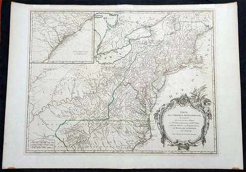
1768 Robert De Vaugondy Large Antique 2nd edition Map of Colonial United States
- Title : Partie De L Amerique Septentrionale, qui Comprend Le Cours De L Ohio...Par le Sr Robert de Vaugondy
- Date : 1768
- Condition: (A+) Fine Condition
- Ref: 93504
- Size: 30in x 21in (760mm x 550mm)
Description:
This large original beautifully hand coloured, scarce 2nd edition antique map of the east coast of the United States, illustrating the course of the Ohio River and stretching from New England to the Carolinas, north to the Great Lakes and south to the Mississippi - with an inset map of The Carolinas - was published in 1768 by Robert Du Vaugondy in his Atlas Universal.
This is one of the best examples of this map I have seen, beautiful hand colour on age toned heavy paper with original margins with a heavy dark ink denoting an early pressing.
General Definitions:
Paper thickness and quality: - Heavy and stable
Paper color : - off white
Age of map color: - Original & later
Colors used: - Yellow, green, blue, pink
General color appearance: - Authentic
Paper size: - 30in x 22in (760mm x 560mm)
Plate size: - 25in x 19 1/2in (635mm x 495mm)
Margins: - Min 1in (25mm)
Imperfections:
Margins: - None
Plate area: - None
Verso: - None
Background:
Second state of the early de Vaugondy map of the British colonies, with changes after the 1763 Treaty of Paris, with Virginia & Carolina extended to the Mississippi and Pennsylvania extended to Lake Erie. The majority of geographical information is based upon John Mitchells great map of North America from the mid 1750s, also drawing from Lewis, Evans on the Middle British Colonies and Joshua Frys and Peter Jeffersons map of Virginia and Maryland. The Mitchell map was the culmination of many years of British surveying in the North American Colonies and was considered one of the best maps of the continent available to Europeans and Americans in the mid-eighteenth century.
De Vaugondys rendition does not copy the full scope of Mitchells map but instead focuses on the colonies stretching from southern Maine to the Carolinas. In the top left corner is an inset of South Carolina and Georgia. De Vaugondy also pays special attention to the river systems and settlements. This map shows some of the earliest accurate information of the trans-Allegheny regions (the Ohio River, Kentucky, Tennessee and Parts of Ohio) and inland areas to the southeast of the Great Lakes and interior of New England.
Maine is still part of the Massachusetts Bay Colony. During this era. The dispute between New Hampshire and New York over who controlled the area which is now Vermont has been resolved. The outbreak of the French & Indian War (Seven Years War) briefly suspended interest in the disputed area, and it was not until 1764 that the British crown upheld New Yorks claim to Vermont. Included is a beautiful title cartouche in the Rococo style. (Ref: Tooley; M&B)
1783 R. De Vaugondy Large Antique 1st Post Revolutionary Map of North America
- Title : Amerique Septentrionale ...Les Etats Unis...1783...Robert De Vaugondy
- Ref #: 93503-1
- Size: 27 1/2in x 21 1/2in (700mm x 540mm)
- Date : 1783
- Condition: (A+) Fine Condition
Description:
This large original beautifully hand coloured copper plate antique map of post revolutionary North America & the newly form United States was engraved in 1783 - dated - and was published by Robert De Vaugondy in his large elephant folio Atlas Universal
This map is in beautiful original condition, original margins, original outline colour on strong sturdy paper with a heavy impression. A must for any collector of maps of historical importance.
General Definitions:
Paper thickness and quality: - Heavy and stable
Paper color : - off white
Age of map color: - Original
Colors used: - Blue, pink, red, green, yellow
General color appearance: - Authentic
Paper size: - 27 1/2in x 21 1/2in (700mm x 540mm)
Plate size: - 25 1/2in x 18 1/2in (650mm x 465mm)
Margins: - Min 1in (25mm)
Imperfections:
Margins: - None
Plate area: - None
Verso: - None
Background:
This is Robert De Vaugondys 5th State of his North America map and one of the first to show the newly liberated American States, after the American Revolutionary War 1775 - 1783.
The maps includes an engraved borderline for the newly founded United States as agreed upon by the Treaty of Paris in 1783. Also, the maps title was altered from earlier states to incorporate the name (in French) for the United States, Etats Unis, which also appears on the map itself. This state includes much other new information along with the place names that were added to the previous state, such as the Newport, New York City, and Bermuda. Florida is shown as an archipelago and the coastline of California is quite curious, with a continuation of the coastline in the inset map of the Northwest showing some of the mythical cartography, such as the Sea of the West and River of the West, which were debated among map scholars and explorers until Captain James Cook dispelled these myths in his three Voyages to the Pacific.
The map also locates the area identified as Fou-sang, reflecting the belief that Chinese mariners may have reached America, the location of the mythical colony of Fou-sang. According to some historians such as Charles Godfrey Leland and Joseph de Guignes ( Le Fou-Sang des Chinois est-il lAmérique Mémoires de lAcadémie des Inscriptions et Belles Lettres, tome 28, Paris, 1761), the distances given by Hui Shen (20,000 Chinese li) would locate Fou-sang on the west coast of the American continent, near British Columbia.
1720 Johannes Baptist Homann Large Antique Map of America
- Title : Totius Americae Septentrionalis et Meridionalis Novissima Representatio quam ex fingulis Geographorum Tabulis collecta luci publicae accommodavit...Johannes Baptista Homann
- Ref #: 93506
- Size: 24in x 21in (610mm x 525mm)
- Date : 1720
- Condition: (A+) Fine Condition
Description:
This large original beautifully hand coloured copper plate antique map of America was published by Johann Baptist Homann in 1720.
A very nice example of this early landmark American map by one of the greats of 17th & 18th century German cartography.
General Definitions:
Paper thickness and quality: - Heavy and stable
Paper color : - off white
Age of map color: - Original
Colors used: - Blue, pink, red, green, yellow
General color appearance: - Authentic
Paper size: - 24in x 21in (610mm x 525mm)
Plate size: - 22 1/2in x 19in (565mm x 490mm)
Margins: - Min 1in (25mm)
Imperfections:
Margins: - None
Plate area: - None
Verso: - Bottom centerfold rejoined at bottom of map, not affecting the image
Background:
This is the second state of Homanns map of America that includes an elongated northwest Coastline is called Costa Terrae Borealis incognitae detecta a Dom: Ioanne de Gama navigante ex China in Novam Hispaniam. The map provides credit for the discovery of this coastline to João de Gama (1540-1591). João da Gama, the grandson of Vasco da Gama, was a Portuguese explorer and colonial administrator in the Far East, during the last quarter of the 16th century. Da Gama sailed from Macau to the northeast and rounded Japan by north, crossing the Pacific Ocean at the northernmost latitudes. The lands northeast of Japan, which João da Gama discovered, were the subject of legend and speculation in the centuries that followed, inspiring its search by European powers.
Good detail throughout the map, especially in the southwest and near the Great Lakes, which were then actively being explored by the French fur traders and Hudson\'s Bay Company.
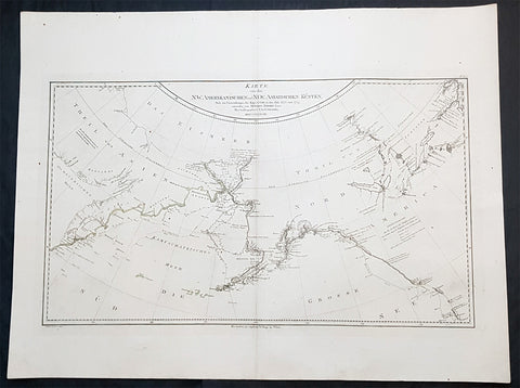
1788 Franz Schraembl & Capt Cook Large Antique Map NW America Alaska, California
- Title : Karte von den N.W. Amerikanischen und N.OE. Asiatischen Kusten nach den Untersuchungen des Kapit. Cook in den Jah. 1778 und 1779
- Ref #: 93436
- Size: 30 1/2in x 23 1/2in (765mm x 575mm)
- Date : 1788
- Condition: (A+) Fine Condition
Description:
This large original copper plate engraved antique map of the discoveries of Captain James Cook in NW America during his third voyage of discovery by Henry Roberts was engraved by I.C. Lackner in 1788 - dated - for the 1788 edition Franz Anton Schraembl edition of the Allgemeiner Grosser Atlas
A rare German language variant of Cooks map of his explorations along the northwest coast of America and the northeast coast of Asia. Based upon original work by Cooks cartographer Henry Roberts. Depicts much of Siberia and Kamtschaka in Asia and, in America, shows Canada as far east as the western portions of Hudson Bay. Alaska and Asia are shown with considerable accuracy though Vancouver Island is missing. Shows several lakes west of Hudson Bay in what is today northwestern Canada. Numerous depth soundings detailed along the exploration tracks. In addition to Cooks work, also notes the explorations of Bodega and the inland discoveries of Hearn, and others.
General Definitions:
Paper thickness and quality: - Heavy and stable
Paper color : - off white
Age of map color: -
Colors used: -
General color appearance: -
Paper size: - 30 1/2in x 23 1/2in (765mm x 575mm)
Plate size: - 28 1/2n x 16 1/2in (725mm x 420mm)
Margins: - Min 2in (50mm)
Imperfections:
Margins: - None
Plate area: - None
Verso: - None
Background:
Cooks Third Voyage (1776-1779)
In the course of his first two voyages, Cook circumnavigated the globe twice, sailed extensively into the Antarctic, and charted coastlines from Newfoundland to New Zealand. Following these achievements, Cooks third voyage was organized to seek an efficient route from England to southern and eastern Asia that would not entail rounding the Cape of Good Hope. The search for such a Northwest (or Northeast) Passage had been on the agenda of northern European mariners and merchants since the beginning of European expansion in the late fifteenth century. England\\\\\\\\\\\\\\\'s growing economic and colonial interests in India in the later eighteenth century provided the stimulus for the latest exploration for this route.
Cook, again in command of the Resolution, was to approach the Northwest Passage from the Pacific accompanied by a second ship, the Discovery, captained by Charles Clerke. The ships left England separately, regrouped at Cape Town, and continued on to Tasmania, New Zealand, and Tahiti. The expedition then sailed north and made landfall at Christmas Island and the Hawaiian Islands. Cook continued northward and charted the west coast of North America from Northern California as far as the Bering Strait. He returned to Hawaii for the winter and was killed in a skirmish with natives on February 14, 1779. Upon Cooks death, Clerke took command of the expedition but died six months later. The ships returned to England in 1780 under John Gore, who had commanded the Discovery after Cooks death. From start to finish, the voyage had lasted more than four years. (Ref Tooley; M&B; Clancy)
Schraembl, Franz Anton 1751-1803
Schraembl was a Vienna based cartographer working in the later part of the 18th century. Schraembl was partnered with Joseph von Reilly. His great work, the Allgemeiner Grosser Atlas was started in 1786. This ambitious atlas was to be based upon only the most up-to-date cartographic information available. Schraembl pulled his maps from the work of explorers such as Cook, Roberts, and others. The atlas was finally finished in 1800 but, possibly restricted by its high production cost, enjoyed only relatively minimal circulation.
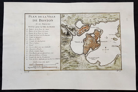
1756 J N Bellin Antique Map of The City of Boston & Charlestown
- Title : Plan de la Ville De Boston et ses Environs
- Ref #: 93417
- Size: 14 1/2in x 9 1/2in (350mm x 240mm)
- Date : 1756
- Condition: (A+) Fine Condition
Description:
This original hand coloured copper plate engraved antique map of Boston and surrounding areas - one of the earliest obtainable maps of the city - by Jacques Nicholas Bellin in 1756 - was published in the French edition of Antoine-François Prevosts 20 volume L Histoire Generale des Voyages published by Pierre de Hondt in the Hague between 1747 & 1785.
Beautiful map with great street and building detail in both Boston and Charlestown, showing parts of Ronde Isle and the mainland. Important buildings and areas identified in an idex at the left of the map. Including three cannon batteries, the Presbyterian Church, the Quaker temple, the Anabaptist Church, the City Hall, the Armory, Faneuil Hall (Spelled Fanal), etc. (Ref: Tooley; M&B)
General Definitions:
Paper thickness and quality: - Heavy and stable
Paper color : - off white
Age of map color: - Early
Colors used: - Yellow, green, blue, pink
General color appearance: - Authentic
Paper size: - 14 1/2in x 9 1/2in (350mm x 240mm)
Plate size: - 11 1/2in x 7 1/2in (285mm x 190mm)
Margins: - Min 1in (25mm)
Imperfections:
Margins: - None
Plate area: - Folds as issued
Verso: - None
Background:
Boston is the capital city and most populous municipality of the Commonwealth of Massachusetts in the United States.
Boston is one of the oldest cities in the United States, founded on the Shawmut Peninsula in 1630 by Puritan settlers from England. It was the scene of several key events of the American Revolution, such as the Boston Massacre, the Boston Tea Party, the Battle of Bunker Hill, and the Siege of Boston. Upon U.S. independence from Great Britain, it continued to be an important port and manufacturing hub as well as a center for education and culture.
In the 1820s, Boston\\\\\\\\\\\\\\\'s population grew rapidly, and the city\\\\\\\\\\\\\\\'s ethnic composition changed dramatically with the first wave of European immigrants. Irish immigrants dominated the first wave of newcomers during this period, especially following the Irish Potato Famine; by 1850, about 35,000 Irish lived in Boston. In the latter half of the 19th century, the city saw increasing numbers of Irish, Germans, Lebanese, Syrians, French Canadians, and Russian and Polish Jews settling in the city. By the end of the 19th century, Boston\\\\\\\\\\\\\\\'s core neighborhoods had become enclaves of ethnically distinct immigrants. Italians inhabited the North End, Irish dominated South Boston and Charlestown, and Russian Jews lived in the West End. Irish and Italian immigrants brought with them Roman Catholicism. Currently, Catholics make up Boston\\\\\\\\\\\\\\\'s largest religious community and the Irish have played a major role in Boston politics since the early 20th century; prominent figures include the Kennedys, Tip O\\\\\\\\\\\\\\\'Neill, and John F. Fitzgerald.
Between 1631 and 1890, the city tripled its area through land reclamation by filling in marshes, mud flats, and gaps between wharves along the waterfront. The largest reclamation efforts took place during the 19th century; beginning in 1807, the crown of Beacon Hill was used to fill in a 50-acre mill pond that later became the Haymarket Square area. The present-day State House sits atop this lowered Beacon Hill. Reclamation projects in the middle of the century created significant parts of the South End, the West End, the Financial District, and Chinatown.
After the Great Boston Fire of 1872, workers used building rubble as landfill along the downtown waterfront. During the mid- to-late 19th century, workers filled almost 600 acres of brackish Charles River marshlands west of Boston Common with gravel brought by rail from the hills of Needham Heights. The city annexed the adjacent towns of South Boston (1804), East Boston (1836), Roxbury (1868), Dorchester (including present day Mattapan and a portion of South Boston) (1870), Brighton (including present day Allston) (1874), West Roxbury (including present day Jamaica Plain and Roslindale) (1874), Charlestown (1874), and Hyde Park (1912). Other proposals were unsuccessful for the annexation of Brookline, Cambridge and Chelsea.
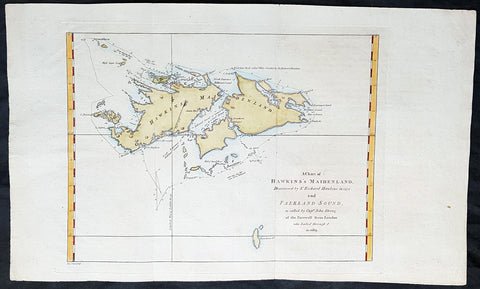
1773 Commodore John Byron 1st Ed Antique Map of The Falkland Islands Sth America
- Title : A chart of Hawkins s Maidenland, discovered by Sr. Richard Hawkins in 1574 and Falkland Sound, so called by Capn. John Strong of the Farewell from London who sailed through it in 1689.
- Ref #: 93385
- Size: 16 1/2in x 10n (405mm x 255mm)
- Date : 1773
- Condition: (A+) Fine Condition
Description:
This original hand coloured copper-plate engraved antique map of the Falkland Islands by Commodore John Byron was engraved by Isaac Noval and published in the 1773 first English edition of John Hawkesworth important book An account of the voyages undertaken by the order of His present Majesty for making discoveries in the Southern Hemisphere, and successively performed by Commodore Byron, Captain Wallis, Captain Carteret, and Captain Cook, in the Dolphin, the Swallow, and the Endeavor. Drawn up from the journals which were kept by the several commanders, and from the papers of Joseph Banks, Esq; by John Hawkesworth, LL.D. In three volumes. Illustrated with cuts, and a great variety of charts and maps relative to countries now first discovered, or hitherto but imperfectly known. London: printed for W. Strahan; and T. Cadell in the Strand, MDCCLXXIII.
John Hawkesworth (1715 - 1773) was commissioned by the British Admiralty to edit Captain James Cooks papers relative to his first voyage. For this work An Account of the Voyages undertaken ... for making discoveries in the Southern Hemisphere and performed by Commodore John Byron, Captain Wallis, Captain Carteret and Captain Cook, from 1702 to 1771, drawn up from the Journals ... (3 vols, 1773) Hawkesworth is said to have received from the publishers the sum of £6000. His descriptions of the manners and customs of the South Seas were, however, regarded by many critics as inexact and hurtful to the interests of morality, and the severity of their strictures is said to have hastened his death. He was buried in the parish church at Bromley, Kent, where he and his wife had kept a school.
General Definitions:
Paper thickness and quality: - Heavy and stable
Paper color : - off white
Age of map color: - Early
Colors used: - Yellow, green, blue, pink
General color appearance: - Authentic
Paper size: - 16 1/2in x 10n (405mm x 255mm)
Plate size: - 12 1/2in x 9 1/2in (310mm x 240mm)
Margins: - Min 1in (25mm)
Imperfections:
Margins: - None
Plate area: - Folds as issued
Verso: - None
Background:
Although Fuegians from Patagonia may have visited the Falkland Islands in prehistoric times, the islands were uninhabited when Europeans first discovered them. Claims of discovery date back to the 16th century, but no consensus exists on whether early explorers discovered the Falklands or other islands in the South Atlantic. The first recorded landing on the islands is attributed to English captain John Strong, who, en route to Perus and Chiles littoral in 1690, discovered the Falkland Sound and noted the islands water and game.
The Falklands remained uninhabited until the 1764 establishment of Port Louis on East Falkland by French captain Louis Antoine de Bougainville, and the 1766 foundation of Port Egmont on Saunders Island by British captain John MacBride. Whether or not the settlements were aware of each others existence is debated by historians. In 1766, France surrendered its claim on the Falklands to Spain, which renamed the French colony Puerto Soledad the following year. Problems began when Spain discovered and captured Port Egmont in 1770. War was narrowly avoided by its restitution to Britain in 1771.
Both the British and Spanish settlements coexisted in the archipelago until 1774, when Britains new economic and strategic considerations led it to voluntarily withdraw from the islands, leaving a plaque claiming the Falklands for King George III. Spains Viceroyalty of the Río de la Plata became the only governmental presence in the territory. West Falkland was left abandoned, and Puerto Soledad became mostly a prison camp. Amid the British invasions of the Río de la Plata during the Napoleonic Wars in Europe, the islands governor evacuated the archipelago in 1806; Spains remaining colonial garrison followed suit in 1811, except for gauchos and fishermen who remained voluntarily.
Thereafter, the archipelago was visited only by fishing ships; its political status was undisputed until 1820, when Colonel David Jewett, an American privateer working for the United Provinces of the Río de la Plata, informed anchored ships about Buenos Aires 1816 claim to Spains territories in the South Atlantic. Since the islands had no permanent inhabitants, in 1823 Buenos Aires granted German-born merchant Luis Vernet permission to conduct fishing activities and exploit feral cattle in the archipelago. Vernet settled at the ruins of Puerto Soledad in 1826, and accumulated resources on the islands until the venture was secure enough to bring settlers and form a permanent colony. Buenos Aires named Vernet military and civil commander of the islands in 1829, and he attempted to regulate sealing to stop the activities of foreign whalers and sealers. Vernets venture lasted until a dispute over fishing and hunting rights led to a raid by the American warship USS Lexington in 1831, when United States Navy commander Silas Duncan declared the dissolution of the islands government.
Buenos Aires attempted to retain influence over the settlement by installing a garrison, but a mutiny in 1832 was followed the next year by the arrival of British forces who reasserted Britains rule. The Argentine Confederation (headed by Buenos Aires Governor Juan Manuel de Rosas) protested against Britains actions and Argentine governments have continued since then to register official protests against Britain. The British troops departed after completing their mission, leaving the area without formal government. Vernets deputy, the Scotsman Matthew Brisbane, returned to the islands that year to restore the business, but his efforts ended after, amid unrest at Port Louis, gaucho Antonio Rivero led a group of dissatisfied individuals to murder Brisbane and the settlements senior leaders; survivors hid in a cave on a nearby island until the British returned and restored order. In 1840, the Falklands became a Crown colony, and Scottish settlers subsequently established an official pastoral community. Four years later, nearly everyone relocated to Port Jackson, considered a better location for government, and merchant Samuel Lafone began a venture to encourage British colonisation.
Stanley, as Port Jackson was soon renamed, officially became the seat of government in 1845. Early in its history, Stanley had a negative reputation due to cargo-shipping losses; only in emergencies would ships rounding Cape Horn stop at the port. Nevertheless, the Falklands geographic location proved ideal for ship repairs and the Wrecking Trade, the business of selling and buying shipwrecks and their cargoes. Aside from this trade, commercial interest in the archipelago was minimal due to the low-value hides of the feral cattle roaming the pastures. Economic growth began only after the Falkland Islands Company, which bought out Lafones failing enterprise in 1851, successfully introduced Cheviot sheep for wool farming, spurring other farms to follow suit. The high cost of importing materials, combined with the shortage of labour and consequent high wages, meant the ship repair trade became uncompetitive. After 1870, it declined as the replacement of sail ships by steamships was accelerated by the low cost of coal in South America; by 1914, with the opening of the Panama Canal, the trade effectively ended. In 1881, the Falkland Islands became financially independent of Britain. For more than a century, the Falkland Islands Company dominated the trade and employment of the archipelago; in addition, it owned most housing in Stanley, which greatly benefited from the wool trade with the UK.
Byron, John 1723 – 1786
Vice-Admiral John Byron (8 November 1723 – 10 April 1786) was a British Royal Navy officer and explorer. He earned the nickname Foul-Weather Jack in the press because of his frequent encounters with bad weather at sea. As a midshipman, he sailed in the squadron under George Anson on his voyage around the world, though Byron made it only to southern Chile, where his ship was wrecked. He returned to England with the captain of HMS Wager. He was governor of Newfoundland following Hugh Palliser, who left in 1768. He circumnavigated the world as a commodore with his own squadron in 1764–1766. He fought in battles in the Seven Years War and the American Revolution. He rose to Vice Admiral of the White before his death in 1786.
His grandsons include the poet George Gordon Byron and George Anson Byron, admiral and explorer, who were the 6th and 7th Baron Byron, respectively.
Byron was the second son of William Byron, 4th Baron Byron and Frances Berkeley, the daughter of William, 4th Baron Berkeley. After studying at Westminster School he joined the Royal Navy at the age of 14, making his first voyage aboard the HMS Romney in 1738–40.
In 1740, he accompanied George Anson on his voyage around the world as a midshipman aboard one of the several ships in the squadron. On 14 May 1741, HMS Wager under Captain Cheap (as Captain Dandy Kidd had died), was shipwrecked on the coast of Chile on what is now called Wager Island and Byron was one of the survivors. The survivors decided to split in two teams, one to make its way by boat to Rio de Janeiro on the Atlantic coast; the other, including John Byron and the Captain, to sail north along the Spanish colonial coast.
Captain Cheap at Wager Island had a party of 19 men after the deserters rejoined the camp. This included the surgeon Elliot and Lieutenant Hamilton who had been cast adrift with him plus midshipmen John Byron and Campbell who had been in the barge. They rowed up the coast but were punished by continuous rain, headwinds and waves that threatened the boats. One night while the men slept on shore, one of the boats was capsized while at anchor and was swept out to sea with its two boatkeepers. One of the men got ashore but the other drowned. As it was now impossible for them all to fit in the remaining boat, four marines were left ashore with muskets to fend for themselves. The winds prevented them from getting around the headland so they returned to pick up the marines only to find them gone. They returned to Wager Island in early February 1742. With one death on the journey, there were now 13 in the group.
Martín Olleta, a Chono cheftain, guided the men up the coast to the Spanish settlements of Chiloé Island so they set out again. Two men died; after burying the bodies, the six seamen rowed off in the boat never to be seen again while Cheap, Hamilton, Byron, Campbell and the dying Elliot were on shore looking for food. Olleta then agreed to take the remaining four on by canoe for their only remaining possession, a musket. It is likely the party travelled across Presidente Ríos Lake in inland Taitao Peninsula, a lake Chile regarded as officially discovered in 1945. Eventually they made it to be taken prisoner by the Spanish. The Spaniards treated them well and they were eventually taken to the inland capital of Santiago where they were released on parole. The Spaniards heard that Anson had been generous in the treatment of the prisoners he had taken and this kindness was returned.
Byron and the other three men stayed in Santiago till late 1744 and were offered passage on a French ship bound for Spain. Three accepted the passage. Campbell elected to take a mule across the Andes and joined the Spanish Admiral Pizarro in Montevideo on the Asia only to find Isaac Morris and the two seamen who had been abandoned in Freshwater Bay on the Atlantic coast. After time in prison in Spain, Campbell reached Britain in May 1746, followed by the other three two months later.
In England, the official court martial examined only the loss of the Wager in which Baynes, in nominal charge at the time, was acquitted of blame but reprimanded for omissions of duty. Disputes over what happened after the wreck were instead played out as Bulkeley and Cummins, Campbell, Morris, the cooper Young and later Byron published their own accounts, the last of which was the only one that in any way defended Cheap who had since died. Twenty-nine crew members plus seven marines made it back to England.
Byrons account of his adventures and the Wager Mutiny are recounted in The Narrative of the Honourable John Byron (1768). His book sold well enough to be printed in several editions.
Byron was appointed captain of HMS Siren in December 1746.
In 1760, during the Seven Years War, Byron commanded a squadron sent to destroy the fortifications at Louisbourg, Quebec, which had been captured by the British two years before. They wanted to ensure it could not be used by the French in Canada. In July of that year he defeated the French flotilla sent to relieve New France at the Battle of Restigouche.
In early 1764 the British Admiralty determined that it would require a permanent naval settlement off the South American coast, in order to resupply naval vessels seeking to enter the Pacific via Cape Horn. Captain Byron was selected to explore the South Atlantic for a suitable island upon which to establish such a settlement. The South American mainland was controlled by Spain, which was hostile to local expansion of British interests; to disguise Byrons mission it was announced that he had been appointed the new Navy Commander-in-Chief, East Indies. Byron set sail in June 1764, ostensibly to take up the East Indies post. For the voyage he was granted command of the 24-gun frigate HMS Dolphin and the 16-gun sloop HMS Tamar.
Byrons two-vessel flotilla crossed the Atlantic over the winter of 1764 and made its way slowly down the South American coast. The Admiralty had ordered Byron to first seek Pepys Island, reputedly discovered off the Patagonian coast by the corsair Ambrose Cowley in 1683. Byron reached the co-ordinates given by Cowley in January 1765, but there was no sign of the island and the search was swiftly abandoned. On 5 February Byron reached the Patagonian settlement of Port Desire where he resupplied his vessels from the storeship HMS Florida.
Between June 1764 and May 1766, Byron completed his own circumnavigation of the globe as captain of HMS Dolphin. This was the first such circumnavigation that was accomplished in less than 2 years. His actions nearly caused a war between Great Britain and Spain, as both countries had armed fleets ready to contest the sovereignty of the Falkland Islands. Later Byron encountered islands and extant residents of the Tuamotus and Tokelau Islands, and Nikunau in the southern Gilbert Islands; he also visited Tinian in the Northern Marianas Islands. A notable member of Byrons crew was Masters Mate Erasmus Gower whom Byron chose to take a significant part in the ceremony when he took possession of the Falkland Islands. Byron had examined Gower for his lieutenants examination in 1762 and was so impressed that he chose him to accompany him on his own circumnavigation (1764–65) and ensured that he was appointed as lieutenant to Commander Philip Carteret immediately afterwards in the next circumnavigation (1766–69).
In 1769 he was appointed governor of Newfoundland off the mainland of Canada, an office he held for the next three years.
He was promoted to rear admiral on 31 March 1775. In 1779, he served as Commander-in-chief of the Leeward Islands Station during the American War of Independence. After being severely injured during a storm on his way to the West Indies, Byron unsuccessfully attacked a French fleet under the Comte dEstaing at the Battle of Grenada in July 1779. He subsequently resigned his post and returned to England, where he suffered from poor health for the rest of his life.
Byron was briefly Commander-in-Chief, North American Station from 1 October 1779. He was made vice admiral of the white in September 1780.
John Byron died on 1 April 1786 at home in Bolton Row, London. His remains were buried in the Berkeley family vault situated beneath the chancel of the Church of St Mary the Virgin, Twickenham, on 10 April.
Johns life was a great inspiration for his grandson the poet George Gordon Byron, though they never met. The poet both drew from his grandfathers experiences in his writing, using his Narrative for the shipwreck scene in Don Juan, and wrote of the kinship he felt in having such a turbulent, unlucky life: he wrote in an epistle to his half-sister Augusta Leigh that he had no rest at sea, nor I on shore.
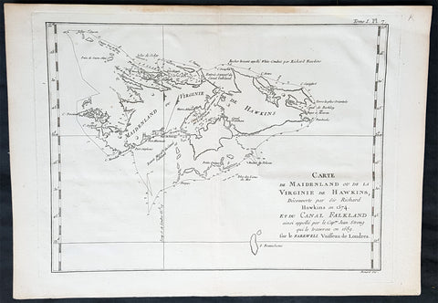
1774 Commodore John Byron Antique Map of The Falkland Islands South America
- Title : Carte de Maidenland ou de la Virginie de Hawkins...et du Canal Falklands...Jean Strong...1689.
- Ref #: 93381
- Size: 14 1/2in x 10in (370mm x 255mm)
- Date : 1774
- Condition: (A+) Fine Condition
Description:
This original copper-plate engraved antique map of the Falkland Islands by Commodore John Byron was engraved by Robert Benard and published in the 1774 first French edition of John Hawkesworth important book An account of the voyages undertaken by the order of His present Majesty for making discoveries in the Southern Hemisphere, and successively performed by Commodore Byron, Captain Wallis, Captain Carteret, and Captain Cook, in the Dolphin, the Swallow, and the Endeavor. Drawn up from the journals which were kept by the several commanders, and from the papers of Joseph Banks, Esq; by John Hawkesworth, LL.D. In three volumes. Illustrated with cuts, and a great variety of charts and maps relative to countries now first discovered, or hitherto but imperfectly known. London: printed for W. Strahan; and T. Cadell in the Strand, MDCCLXXIII.
John Hawkesworth (1715 - 1773) was commissioned by the British Admiralty to edit Captain James Cooks papers relative to his first voyage. For this work An Account of the Voyages undertaken ... for making discoveries in the Southern Hemisphere and performed by Commodore John Byron, Captain Wallis, Captain Carteret and Captain Cook, from 1702 to 1771, drawn up from the Journals ... (3 vols, 1773) Hawkesworth is said to have received from the publishers the sum of £6000. His descriptions of the manners and customs of the South Seas were, however, regarded by many critics as inexact and hurtful to the interests of morality, and the severity of their strictures is said to have hastened his death. He was buried in the parish church at Bromley, Kent, where he and his wife had kept a school.
Background:
Although Fuegians from Patagonia may have visited the Falkland Islands in prehistoric times, the islands were uninhabited when Europeans first discovered them. Claims of discovery date back to the 16th century, but no consensus exists on whether early explorers discovered the Falklands or other islands in the South Atlantic. The first recorded landing on the islands is attributed to English captain John Strong, who, en route to Perus and Chiles littoral in 1690, discovered the Falkland Sound and noted the islands water and game.
The Falklands remained uninhabited until the 1764 establishment of Port Louis on East Falkland by French captain Louis Antoine de Bougainville, and the 1766 foundation of Port Egmont on Saunders Island by British captain John MacBride. Whether or not the settlements were aware of each others existence is debated by historians. In 1766, France surrendered its claim on the Falklands to Spain, which renamed the French colony Puerto Soledad the following year. Problems began when Spain discovered and captured Port Egmont in 1770. War was narrowly avoided by its restitution to Britain in 1771.
Both the British and Spanish settlements coexisted in the archipelago until 1774, when Britains new economic and strategic considerations led it to voluntarily withdraw from the islands, leaving a plaque claiming the Falklands for King George III. Spains Viceroyalty of the Río de la Plata became the only governmental presence in the territory. West Falkland was left abandoned, and Puerto Soledad became mostly a prison camp. Amid the British invasions of the Río de la Plata during the Napoleonic Wars in Europe, the islands governor evacuated the archipelago in 1806; Spains remaining colonial garrison followed suit in 1811, except for gauchos and fishermen who remained voluntarily.
Thereafter, the archipelago was visited only by fishing ships; its political status was undisputed until 1820, when Colonel David Jewett, an American privateer working for the United Provinces of the Río de la Plata, informed anchored ships about Buenos Aires 1816 claim to Spains territories in the South Atlantic. Since the islands had no permanent inhabitants, in 1823 Buenos Aires granted German-born merchant Luis Vernet permission to conduct fishing activities and exploit feral cattle in the archipelago. Vernet settled at the ruins of Puerto Soledad in 1826, and accumulated resources on the islands until the venture was secure enough to bring settlers and form a permanent colony. Buenos Aires named Vernet military and civil commander of the islands in 1829, and he attempted to regulate sealing to stop the activities of foreign whalers and sealers. Vernets venture lasted until a dispute over fishing and hunting rights led to a raid by the American warship USS Lexington in 1831, when United States Navy commander Silas Duncan declared the dissolution of the islands government.
Buenos Aires attempted to retain influence over the settlement by installing a garrison, but a mutiny in 1832 was followed the next year by the arrival of British forces who reasserted Britains rule. The Argentine Confederation (headed by Buenos Aires Governor Juan Manuel de Rosas) protested against Britains actions and Argentine governments have continued since then to register official protests against Britain. The British troops departed after completing their mission, leaving the area without formal government. Vernets deputy, the Scotsman Matthew Brisbane, returned to the islands that year to restore the business, but his efforts ended after, amid unrest at Port Louis, gaucho Antonio Rivero led a group of dissatisfied individuals to murder Brisbane and the settlements senior leaders; survivors hid in a cave on a nearby island until the British returned and restored order. In 1840, the Falklands became a Crown colony, and Scottish settlers subsequently established an official pastoral community. Four years later, nearly everyone relocated to Port Jackson, considered a better location for government, and merchant Samuel Lafone began a venture to encourage British colonisation.
Stanley, as Port Jackson was soon renamed, officially became the seat of government in 1845. Early in its history, Stanley had a negative reputation due to cargo-shipping losses; only in emergencies would ships rounding Cape Horn stop at the port. Nevertheless, the Falklands geographic location proved ideal for ship repairs and the Wrecking Trade, the business of selling and buying shipwrecks and their cargoes. Aside from this trade, commercial interest in the archipelago was minimal due to the low-value hides of the feral cattle roaming the pastures. Economic growth began only after the Falkland Islands Company, which bought out Lafones failing enterprise in 1851, successfully introduced Cheviot sheep for wool farming, spurring other farms to follow suit. The high cost of importing materials, combined with the shortage of labour and consequent high wages, meant the ship repair trade became uncompetitive. After 1870, it declined as the replacement of sail ships by steamships was accelerated by the low cost of coal in South America; by 1914, with the opening of the Panama Canal, the trade effectively ended. In 1881, the Falkland Islands became financially independent of Britain. For more than a century, the Falkland Islands Company dominated the trade and employment of the archipelago; in addition, it owned most housing in Stanley, which greatly benefited from the wool trade with the UK.
General Definitions:
Paper thickness and quality: - Heavy and stable
Paper color : - off white
Age of map color: - Early
Colors used: - Yellow, green, blue, pink
General color appearance: - Authentic
Paper size: - 14 1/2in x 10in (370mm x 255mm)
Plate size: - 12 1/2in x 9 1/2in (310mm x 240mm)
Margins: - Min 1in (25mm)
Imperfections:
Margins: - None
Plate area: - Folds as issued
Verso: - None
Byron, John 1723 – 1786:
Vice-Admiral John Byron (8 November 1723 – 10 April 1786) was a British Royal Navy officer and explorer. He earned the nickname Foul-Weather Jack in the press because of his frequent encounters with bad weather at sea. As a midshipman, he sailed in the squadron under George Anson on his voyage around the world, though Byron made it only to southern Chile, where his ship was wrecked. He returned to England with the captain of HMS Wager. He was governor of Newfoundland following Hugh Palliser, who left in 1768. He circumnavigated the world as a commodore with his own squadron in 1764–1766. He fought in battles in the Seven Years War and the American Revolution. He rose to Vice Admiral of the White before his death in 1786.
His grandsons include the poet George Gordon Byron and George Anson Byron, admiral and explorer, who were the 6th and 7th Baron Byron, respectively.
Byron was the second son of William Byron, 4th Baron Byron and Frances Berkeley, the daughter of William, 4th Baron Berkeley. After studying at Westminster School he joined the Royal Navy at the age of 14, making his first voyage aboard the HMS Romney in 1738–40.
In 1740, he accompanied George Anson on his voyage around the world as a midshipman aboard one of the several ships in the squadron. On 14 May 1741, HMS Wager under Captain Cheap (as Captain Dandy Kidd had died), was shipwrecked on the coast of Chile on what is now called Wager Island and Byron was one of the survivors. The survivors decided to split in two teams, one to make its way by boat to Rio de Janeiro on the Atlantic coast; the other, including John Byron and the Captain, to sail north along the Spanish colonial coast.
Captain Cheap at Wager Island had a party of 19 men after the deserters rejoined the camp. This included the surgeon Elliot and Lieutenant Hamilton who had been cast adrift with him plus midshipmen John Byron and Campbell who had been in the barge. They rowed up the coast but were punished by continuous rain, headwinds and waves that threatened the boats. One night while the men slept on shore, one of the boats was capsized while at anchor and was swept out to sea with its two boatkeepers. One of the men got ashore but the other drowned. As it was now impossible for them all to fit in the remaining boat, four marines were left ashore with muskets to fend for themselves. The winds prevented them from getting around the headland so they returned to pick up the marines only to find them gone. They returned to Wager Island in early February 1742. With one death on the journey, there were now 13 in the group.
Martín Olleta, a Chono cheftain, guided the men up the coast to the Spanish settlements of Chiloé Island so they set out again. Two men died; after burying the bodies, the six seamen rowed off in the boat never to be seen again while Cheap, Hamilton, Byron, Campbell and the dying Elliot were on shore looking for food. Olleta then agreed to take the remaining four on by canoe for their only remaining possession, a musket. It is likely the party travelled across Presidente Ríos Lake in inland Taitao Peninsula, a lake Chile regarded as officially discovered in 1945. Eventually they made it to be taken prisoner by the Spanish. The Spaniards treated them well and they were eventually taken to the inland capital of Santiago where they were released on parole. The Spaniards heard that Anson had been generous in the treatment of the prisoners he had taken and this kindness was returned.
Byron and the other three men stayed in Santiago till late 1744 and were offered passage on a French ship bound for Spain. Three accepted the passage. Campbell elected to take a mule across the Andes and joined the Spanish Admiral Pizarro in Montevideo on the Asia only to find Isaac Morris and the two seamen who had been abandoned in Freshwater Bay on the Atlantic coast. After time in prison in Spain, Campbell reached Britain in May 1746, followed by the other three two months later.
In England, the official court martial examined only the loss of the Wager in which Baynes, in nominal charge at the time, was acquitted of blame but reprimanded for omissions of duty. Disputes over what happened after the wreck were instead played out as Bulkeley and Cummins, Campbell, Morris, the cooper Young and later Byron published their own accounts, the last of which was the only one that in any way defended Cheap who had since died. Twenty-nine crew members plus seven marines made it back to England.
Byrons account of his adventures and the Wager Mutiny are recounted in The Narrative of the Honourable John Byron (1768). His book sold well enough to be printed in several editions.
Byron was appointed captain of HMS Siren in December 1746.
In 1760, during the Seven Years War, Byron commanded a squadron sent to destroy the fortifications at Louisbourg, Quebec, which had been captured by the British two years before. They wanted to ensure it could not be used by the French in Canada. In July of that year he defeated the French flotilla sent to relieve New France at the Battle of Restigouche.
In early 1764 the British Admiralty determined that it would require a permanent naval settlement off the South American coast, in order to resupply naval vessels seeking to enter the Pacific via Cape Horn. Captain Byron was selected to explore the South Atlantic for a suitable island upon which to establish such a settlement. The South American mainland was controlled by Spain, which was hostile to local expansion of British interests; to disguise Byrons mission it was announced that he had been appointed the new Navy Commander-in-Chief, East Indies. Byron set sail in June 1764, ostensibly to take up the East Indies post. For the voyage he was granted command of the 24-gun frigate HMS Dolphin and the 16-gun sloop HMS Tamar.
Byrons two-vessel flotilla crossed the Atlantic over the winter of 1764 and made its way slowly down the South American coast. The Admiralty had ordered Byron to first seek Pepys Island, reputedly discovered off the Patagonian coast by the corsair Ambrose Cowley in 1683. Byron reached the co-ordinates given by Cowley in January 1765, but there was no sign of the island and the search was swiftly abandoned. On 5 February Byron reached the Patagonian settlement of Port Desire where he resupplied his vessels from the storeship HMS Florida.
Between June 1764 and May 1766, Byron completed his own circumnavigation of the globe as captain of HMS Dolphin. This was the first such circumnavigation that was accomplished in less than 2 years. His actions nearly caused a war between Great Britain and Spain, as both countries had armed fleets ready to contest the sovereignty of the Falkland Islands. Later Byron encountered islands and extant residents of the Tuamotus and Tokelau Islands, and Nikunau in the southern Gilbert Islands; he also visited Tinian in the Northern Marianas Islands. A notable member of Byrons crew was Masters Mate Erasmus Gower whom Byron chose to take a significant part in the ceremony when he took possession of the Falkland Islands. Byron had examined Gower for his lieutenants examination in 1762 and was so impressed that he chose him to accompany him on his own circumnavigation (1764–65) and ensured that he was appointed as lieutenant to Commander Philip Carteret immediately afterwards in the next circumnavigation (1766–69).
In 1769 he was appointed governor of Newfoundland off the mainland of Canada, an office he held for the next three years.
He was promoted to rear admiral on 31 March 1775. In 1779, he served as Commander-in-chief of the Leeward Islands Station during the American War of Independence. After being severely injured during a storm on his way to the West Indies, Byron unsuccessfully attacked a French fleet under the Comte dEstaing at the Battle of Grenada in July 1779. He subsequently resigned his post and returned to England, where he suffered from poor health for the rest of his life.
Byron was briefly Commander-in-Chief, North American Station from 1 October 1779. He was made vice admiral of the white in September 1780.
John Byron died on 1 April 1786 at home in Bolton Row, London. His remains were buried in the Berkeley family vault situated beneath the chancel of the Church of St Mary the Virgin, Twickenham, on 10 April.
Johns life was a great inspiration for his grandson the poet George Gordon Byron, though they never met. The poet both drew from his grandfathers experiences in his writing, using his Narrative for the shipwreck scene in Don Juan, and wrote of the kinship he felt in having such a turbulent, unlucky life: he wrote in an epistle to his half-sister Augusta Leigh that he had no rest at sea, nor I on shore.
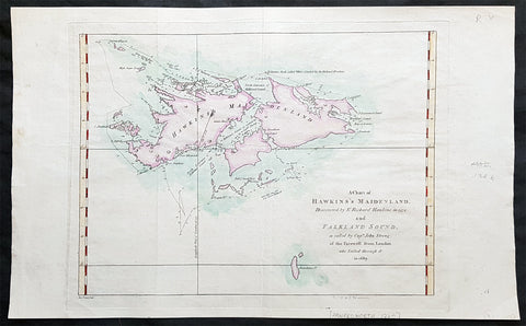
1773 Commodore John Byron 1st Ed Antique Map of The Falkland Islands Sth America
- Title : A chart of Hawkins s Maidenland, discovered by Sr. Richard Hawkins in 1574 and Falkland Sound, so called by Capn. John Strong of the Farewell from London who sailed through it in 1689.
- Ref #: 93384
- Size: 16 1/2in x 10n (405mm x 255mm)
- Date : 1773
- Condition: (A+) Fine Condition
Description:
This original hand coloured copper-plate engraved antique map of the Falkland Islands by Commodore John Byron was engraved by Isaac Noval and published in the 1773 first English edition of John Hawkesworth important book An account of the voyages undertaken by the order of His present Majesty for making discoveries in the Southern Hemisphere, and successively performed by Commodore Byron, Captain Wallis, Captain Carteret, and Captain Cook, in the Dolphin, the Swallow, and the Endeavor. Drawn up from the journals which were kept by the several commanders, and from the papers of Joseph Banks, Esq; by John Hawkesworth, LL.D. In three volumes. Illustrated with cuts, and a great variety of charts and maps relative to countries now first discovered, or hitherto but imperfectly known. London: printed for W. Strahan; and T. Cadell in the Strand, MDCCLXXIII.
John Hawkesworth (1715 - 1773) was commissioned by the British Admiralty to edit Captain James Cooks papers relative to his first voyage. For this work An Account of the Voyages undertaken ... for making discoveries in the Southern Hemisphere and performed by Commodore John Byron, Captain Wallis, Captain Carteret and Captain Cook, from 1702 to 1771, drawn up from the Journals ... (3 vols, 1773) Hawkesworth is said to have received from the publishers the sum of £6000. His descriptions of the manners and customs of the South Seas were, however, regarded by many critics as inexact and hurtful to the interests of morality, and the severity of their strictures is said to have hastened his death. He was buried in the parish church at Bromley, Kent, where he and his wife had kept a school.
General Definitions:
Paper thickness and quality: - Heavy and stable
Paper color : - off white
Age of map color: - Early
Colors used: - Yellow, green, blue, pink
General color appearance: - Authentic
Paper size: - 16 1/2in x 10n (405mm x 255mm)
Plate size: - 12 1/2in x 9 1/2in (310mm x 240mm)
Margins: - Min 1in (25mm)
Imperfections:
Margins: - None
Plate area: - Folds as issued
Verso: - None
Background:
Although Fuegians from Patagonia may have visited the Falkland Islands in prehistoric times, the islands were uninhabited when Europeans first discovered them. Claims of discovery date back to the 16th century, but no consensus exists on whether early explorers discovered the Falklands or other islands in the South Atlantic. The first recorded landing on the islands is attributed to English captain John Strong, who, en route to Perus and Chiles littoral in 1690, discovered the Falkland Sound and noted the islands water and game.
The Falklands remained uninhabited until the 1764 establishment of Port Louis on East Falkland by French captain Louis Antoine de Bougainville, and the 1766 foundation of Port Egmont on Saunders Island by British captain John MacBride. Whether or not the settlements were aware of each others existence is debated by historians. In 1766, France surrendered its claim on the Falklands to Spain, which renamed the French colony Puerto Soledad the following year. Problems began when Spain discovered and captured Port Egmont in 1770. War was narrowly avoided by its restitution to Britain in 1771.
Both the British and Spanish settlements coexisted in the archipelago until 1774, when Britains new economic and strategic considerations led it to voluntarily withdraw from the islands, leaving a plaque claiming the Falklands for King George III. Spains Viceroyalty of the Río de la Plata became the only governmental presence in the territory. West Falkland was left abandoned, and Puerto Soledad became mostly a prison camp. Amid the British invasions of the Río de la Plata during the Napoleonic Wars in Europe, the islands governor evacuated the archipelago in 1806; Spains remaining colonial garrison followed suit in 1811, except for gauchos and fishermen who remained voluntarily.
Thereafter, the archipelago was visited only by fishing ships; its political status was undisputed until 1820, when Colonel David Jewett, an American privateer working for the United Provinces of the Río de la Plata, informed anchored ships about Buenos Aires 1816 claim to Spains territories in the South Atlantic. Since the islands had no permanent inhabitants, in 1823 Buenos Aires granted German-born merchant Luis Vernet permission to conduct fishing activities and exploit feral cattle in the archipelago. Vernet settled at the ruins of Puerto Soledad in 1826, and accumulated resources on the islands until the venture was secure enough to bring settlers and form a permanent colony. Buenos Aires named Vernet military and civil commander of the islands in 1829, and he attempted to regulate sealing to stop the activities of foreign whalers and sealers. Vernets venture lasted until a dispute over fishing and hunting rights led to a raid by the American warship USS Lexington in 1831, when United States Navy commander Silas Duncan declared the dissolution of the islands government.
Buenos Aires attempted to retain influence over the settlement by installing a garrison, but a mutiny in 1832 was followed the next year by the arrival of British forces who reasserted Britains rule. The Argentine Confederation (headed by Buenos Aires Governor Juan Manuel de Rosas) protested against Britains actions and Argentine governments have continued since then to register official protests against Britain. The British troops departed after completing their mission, leaving the area without formal government. Vernets deputy, the Scotsman Matthew Brisbane, returned to the islands that year to restore the business, but his efforts ended after, amid unrest at Port Louis, gaucho Antonio Rivero led a group of dissatisfied individuals to murder Brisbane and the settlements senior leaders; survivors hid in a cave on a nearby island until the British returned and restored order. In 1840, the Falklands became a Crown colony, and Scottish settlers subsequently established an official pastoral community. Four years later, nearly everyone relocated to Port Jackson, considered a better location for government, and merchant Samuel Lafone began a venture to encourage British colonisation.
Stanley, as Port Jackson was soon renamed, officially became the seat of government in 1845. Early in its history, Stanley had a negative reputation due to cargo-shipping losses; only in emergencies would ships rounding Cape Horn stop at the port. Nevertheless, the Falklands geographic location proved ideal for ship repairs and the Wrecking Trade, the business of selling and buying shipwrecks and their cargoes. Aside from this trade, commercial interest in the archipelago was minimal due to the low-value hides of the feral cattle roaming the pastures. Economic growth began only after the Falkland Islands Company, which bought out Lafones failing enterprise in 1851, successfully introduced Cheviot sheep for wool farming, spurring other farms to follow suit. The high cost of importing materials, combined with the shortage of labour and consequent high wages, meant the ship repair trade became uncompetitive. After 1870, it declined as the replacement of sail ships by steamships was accelerated by the low cost of coal in South America; by 1914, with the opening of the Panama Canal, the trade effectively ended. In 1881, the Falkland Islands became financially independent of Britain. For more than a century, the Falkland Islands Company dominated the trade and employment of the archipelago; in addition, it owned most housing in Stanley, which greatly benefited from the wool trade with the UK.
Byron, John 1723 – 1786
Vice-Admiral John Byron (8 November 1723 – 10 April 1786) was a British Royal Navy officer and explorer. He earned the nickname Foul-Weather Jack in the press because of his frequent encounters with bad weather at sea. As a midshipman, he sailed in the squadron under George Anson on his voyage around the world, though Byron made it only to southern Chile, where his ship was wrecked. He returned to England with the captain of HMS Wager. He was governor of Newfoundland following Hugh Palliser, who left in 1768. He circumnavigated the world as a commodore with his own squadron in 1764–1766. He fought in battles in the Seven Years War and the American Revolution. He rose to Vice Admiral of the White before his death in 1786.
His grandsons include the poet George Gordon Byron and George Anson Byron, admiral and explorer, who were the 6th and 7th Baron Byron, respectively.
Byron was the second son of William Byron, 4th Baron Byron and Frances Berkeley, the daughter of William, 4th Baron Berkeley. After studying at Westminster School he joined the Royal Navy at the age of 14, making his first voyage aboard the HMS Romney in 1738–40.
In 1740, he accompanied George Anson on his voyage around the world as a midshipman aboard one of the several ships in the squadron. On 14 May 1741, HMS Wager under Captain Cheap (as Captain Dandy Kidd had died), was shipwrecked on the coast of Chile on what is now called Wager Island and Byron was one of the survivors. The survivors decided to split in two teams, one to make its way by boat to Rio de Janeiro on the Atlantic coast; the other, including John Byron and the Captain, to sail north along the Spanish colonial coast.
Captain Cheap at Wager Island had a party of 19 men after the deserters rejoined the camp. This included the surgeon Elliot and Lieutenant Hamilton who had been cast adrift with him plus midshipmen John Byron and Campbell who had been in the barge. They rowed up the coast but were punished by continuous rain, headwinds and waves that threatened the boats. One night while the men slept on shore, one of the boats was capsized while at anchor and was swept out to sea with its two boatkeepers. One of the men got ashore but the other drowned. As it was now impossible for them all to fit in the remaining boat, four marines were left ashore with muskets to fend for themselves. The winds prevented them from getting around the headland so they returned to pick up the marines only to find them gone. They returned to Wager Island in early February 1742. With one death on the journey, there were now 13 in the group.
Martín Olleta, a Chono cheftain, guided the men up the coast to the Spanish settlements of Chiloé Island so they set out again. Two men died; after burying the bodies, the six seamen rowed off in the boat never to be seen again while Cheap, Hamilton, Byron, Campbell and the dying Elliot were on shore looking for food. Olleta then agreed to take the remaining four on by canoe for their only remaining possession, a musket. It is likely the party travelled across Presidente Ríos Lake in inland Taitao Peninsula, a lake Chile regarded as officially discovered in 1945. Eventually they made it to be taken prisoner by the Spanish. The Spaniards treated them well and they were eventually taken to the inland capital of Santiago where they were released on parole. The Spaniards heard that Anson had been generous in the treatment of the prisoners he had taken and this kindness was returned.
Byron and the other three men stayed in Santiago till late 1744 and were offered passage on a French ship bound for Spain. Three accepted the passage. Campbell elected to take a mule across the Andes and joined the Spanish Admiral Pizarro in Montevideo on the Asia only to find Isaac Morris and the two seamen who had been abandoned in Freshwater Bay on the Atlantic coast. After time in prison in Spain, Campbell reached Britain in May 1746, followed by the other three two months later.
In England, the official court martial examined only the loss of the Wager in which Baynes, in nominal charge at the time, was acquitted of blame but reprimanded for omissions of duty. Disputes over what happened after the wreck were instead played out as Bulkeley and Cummins, Campbell, Morris, the cooper Young and later Byron published their own accounts, the last of which was the only one that in any way defended Cheap who had since died. Twenty-nine crew members plus seven marines made it back to England.
Byrons account of his adventures and the Wager Mutiny are recounted in The Narrative of the Honourable John Byron (1768). His book sold well enough to be printed in several editions.
Byron was appointed captain of HMS Siren in December 1746.
In 1760, during the Seven Years War, Byron commanded a squadron sent to destroy the fortifications at Louisbourg, Quebec, which had been captured by the British two years before. They wanted to ensure it could not be used by the French in Canada. In July of that year he defeated the French flotilla sent to relieve New France at the Battle of Restigouche.
In early 1764 the British Admiralty determined that it would require a permanent naval settlement off the South American coast, in order to resupply naval vessels seeking to enter the Pacific via Cape Horn. Captain Byron was selected to explore the South Atlantic for a suitable island upon which to establish such a settlement. The South American mainland was controlled by Spain, which was hostile to local expansion of British interests; to disguise Byrons mission it was announced that he had been appointed the new Navy Commander-in-Chief, East Indies. Byron set sail in June 1764, ostensibly to take up the East Indies post. For the voyage he was granted command of the 24-gun frigate HMS Dolphin and the 16-gun sloop HMS Tamar.
Byrons two-vessel flotilla crossed the Atlantic over the winter of 1764 and made its way slowly down the South American coast. The Admiralty had ordered Byron to first seek Pepys Island, reputedly discovered off the Patagonian coast by the corsair Ambrose Cowley in 1683. Byron reached the co-ordinates given by Cowley in January 1765, but there was no sign of the island and the search was swiftly abandoned. On 5 February Byron reached the Patagonian settlement of Port Desire where he resupplied his vessels from the storeship HMS Florida.
Between June 1764 and May 1766, Byron completed his own circumnavigation of the globe as captain of HMS Dolphin. This was the first such circumnavigation that was accomplished in less than 2 years. His actions nearly caused a war between Great Britain and Spain, as both countries had armed fleets ready to contest the sovereignty of the Falkland Islands. Later Byron encountered islands and extant residents of the Tuamotus and Tokelau Islands, and Nikunau in the southern Gilbert Islands; he also visited Tinian in the Northern Marianas Islands. A notable member of Byrons crew was Masters Mate Erasmus Gower whom Byron chose to take a significant part in the ceremony when he took possession of the Falkland Islands. Byron had examined Gower for his lieutenants examination in 1762 and was so impressed that he chose him to accompany him on his own circumnavigation (1764–65) and ensured that he was appointed as lieutenant to Commander Philip Carteret immediately afterwards in the next circumnavigation (1766–69).
In 1769 he was appointed governor of Newfoundland off the mainland of Canada, an office he held for the next three years.
He was promoted to rear admiral on 31 March 1775. In 1779, he served as Commander-in-chief of the Leeward Islands Station during the American War of Independence. After being severely injured during a storm on his way to the West Indies, Byron unsuccessfully attacked a French fleet under the Comte dEstaing at the Battle of Grenada in July 1779. He subsequently resigned his post and returned to England, where he suffered from poor health for the rest of his life.
Byron was briefly Commander-in-Chief, North American Station from 1 October 1779. He was made vice admiral of the white in September 1780.
John Byron died on 1 April 1786 at home in Bolton Row, London. His remains were buried in the Berkeley family vault situated beneath the chancel of the Church of St Mary the Virgin, Twickenham, on 10 April.
Johns life was a great inspiration for his grandson the poet George Gordon Byron, though they never met. The poet both drew from his grandfathers experiences in his writing, using his Narrative for the shipwreck scene in Don Juan, and wrote of the kinship he felt in having such a turbulent, unlucky life: he wrote in an epistle to his half-sister Augusta Leigh that he had no rest at sea, nor I on shore.
1860 Edward Weller Large Antique Map of The Pacific - Australia to California
- Title : The Pacific Ocean
- Ref #: 70063
- Size: 26 1/2in x 19in (675mm x 490mm)
- Date : 1860
- Condition: (A+) Fine Condition
Description:
This original steel plate engraved hand coloured antique map by Edward Weller was published in the 1860 edition of The Dispatch Atlas; a compilation of maps Weller had already published in The Weekly Dispatch.
General Definitions:
Paper thickness and quality: - Heavy and stable
Paper color : - off white
Age of map color: - Original
Colors used: - Yellow, Green, pink
General color appearance: - Authentic
Paper size: - 26 1/2in x 19in (675mm x 490mm)
Plate size: - 26 1/2in x 19in (675mm x 490mm)
Margins: - Min 1/2in (10mm)
Imperfections:
Margins: - None
Plate area: - None
Verso: - None
Weller, Edward 1819 – 1884
Weller was a London-based engraver, cartographer and publisher, working from offices in Red Lion Square and later, Bloomsbury. Amongst his considerable portfolio were various atlases, many of which focussed on the educational publishing market. Having established his credentials as an engraver of finely detailed works, he sold maps to be published in a number of regular magazines and pamphlets, perhaps the best known being The Dispatch Atlas; a compilation of maps Weller had already published in The Weekly Dispatch. Although Weller usually engraved the maps himself, he did work in partnership with others, particularly John Dower for this 1858 and 1863 volume. Weller also published The Crown Atlas in 1871.
The Dispatch Atlas featured well over one hundred superbly detailed steel plate engraved maps, usually with simplistic, single colour outline hand colouring, and a distinctive header style. Most English counties featured, some of which were divided onto separate sheets, affording space to engrave in even greater detail. The maps of North and South Devonshire for example include such details as individual property names, as do those of the Northern and Southern parts of Hampshire.
After Wellers death in 1884, many of these astonishingly detailed plates were sold on to other map makers, including George Washington Bacon, who, whilst retaining the level of detail, expanded the printing area of each plate, adding more precise and varied hand colouring in keeping with the final decades of the century.
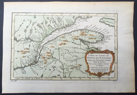
1757 Nicolas Bellin Large Antique Map Mouth of St Lawrence River Quebec, Canada
- Title : Carte Du Cours Du Fleuve De St Laurent...1757
- Size: 15in x 10in (380mm x 255mm)
- Condition: (A+) Fine Condition
- Date : 1757
- Ref #: 61087
Description:
This original copper-plate engraved beautifully hand colored antique mapof the mouth of the St Lawrence River to the city of Quebec, Canada by Jacques Nicolas Bellin was engraved in 1757 - dated - and was published in the French edition of Antoine-François Prevosts 20 volume L Histoire Generale des Voyages published by Pierre de Hondt in the Hague between 1747 & 1785.
General Definitions:
Paper thickness and quality: - Heavy and stable
Paper color : - off white
Age of map color: - Original
Colors used: - Yellow, green, blue, pink
General color appearance: - Authentic
Paper size: - 15in x 10in (380mm x 255mm)
Plate size: - 11in x 8 1/2in (280mm x 215mm)
Margins: - Min 1in (25mm)
Imperfections:
Margins: - None
Plate area: - Folds as issued
Verso: - None
Background:
The Norse explored the Gulf of Saint Lawrence in the 11th century and were followed by fifteenth and early sixteenth century European mariners, such as John Cabot, and the brothers Gaspar and Miguel Corte-Real. The first European explorer known to have sailed up the Saint Lawrence River itself was Jacques Cartier. At that time, the land along the river was inhabited by the St. Lawrence Iroquoians; at the time of Cartiers second voyage in 1535. Because Cartier arrived in the estuary on Saint Lawrences feast day, he named it the Gulf of Saint Lawrence. The Saint Lawrence River is partly within the U.S. and as such is that countrys sixth oldest surviving European place-name.
The earliest regular Europeans in the area were the Basques, who came to the St Lawrence Gulf and River in pursuit of whales from the early 16th century. The Basque whalers and fishermen traded with indigenous Americans and set up settlements, leaving vestiges all over the coast of eastern Canada and deep into the Saint Lawrence River. Basque commercial and fishing activity reached its peak before the Armada Invencibles disaster (1588), when the Spanish Basque whaling fleet was confiscated by King Philip II of Spain and largely destroyed. Initially, the whaling galleons from Labourd were not affected by the Spanish defeat.
Until the early 17th century, the French used the name Rivière du Canada to designate the Saint Lawrence upstream to Montreal and the Ottawa River after Montreal. The Saint Lawrence River served as the main route for European exploration of the North American interior, first pioneered by French explorer Samuel de Champlain.
Control of the river was crucial to British strategy to capture New France in the Seven Years War. Having captured Louisbourg in 1758, the British sailed up to Quebec the following year thanks to charts drawn up by James Cook. British troops were ferried via the Saint Lawrence to attack the city from the west, which they successfully did at the Battle of the Plains of Abraham. The river was used again by the British to defeat the French siege of Quebec under the Chevalier de Lévis in 1760.
In 1809, the first steamboat to ply its trade on the St. Lawrence was built and operated by John Molson and associates, a scant two years after Fultons steam-powered navigation of the Hudson River. The Accommodation with ten passengers made her maiden voyage from Montreal to Quebec City in 66 hours, for 30 of which she was at anchor. She had a keel of 75 feet, and length overall of 85 feet. The cost of a ticket as eight dollars upstream, and nine dollars down. She had berths that year for twenty passengers.
Within a decade, daily service was available in the hotly-contested Montreal-Quebec route.
Because of the virtually impassable Lachine Rapids, the Saint Lawrence was once continuously navigable only as far as Montreal. Opened in 1825, the Lachine Canal was the first to allow ships to pass the rapids. An extensive system of canals and locks, known as the Saint Lawrence Seaway, was officially opened on 26 June 1959 by Elizabeth II (representing Canada) and President Dwight D. Eisenhower (representing the United States). The Seaway (including the Welland Canal) now permits ocean-going vessels to pass all the way to Lake Superior.
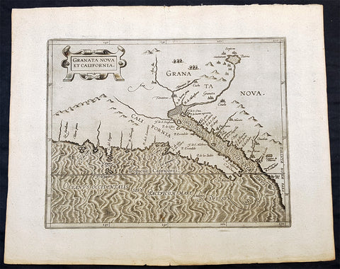
1597 Cornelis Wytfliet Antique Map Early Important Map of California & SW America
- Title : Granata Nova et California
- Size: 15in x 12in (380mm x 305mm)
- Condition: (A+) Fine Condition
- Date : 1597
- Ref #: 41716
Description:
A fine original antique, and incredibly important map the first to focus on California & the SW was published by Cornelis van Wytfliet in the 1597 edition of Descriptionis Ptolemaicae Augmentum.
The first printed map devoted to California and the south-west of the present day United States. One of the most interesting features is the depiction of so many fabled places largely from Spanish sources. Most notable amongst these are the seven cities of Cibola. The seven cities originated from the narrative of Fray Marcos de Niza in 1539. Some of the other nomenclature originates from Coronados epic exploration. The outline map is fairly accurate and is derived largely from Petrus Plancius large world map of 1592. The main coastal irregularity is the westward slant of the Californian coastline. Bearing in mind that it would be shown as part of an island in twenty five years, this is quite forgivable. No other states of the map are known and all issues are without text on the back (Burden 106).
General Definitions:
Paper thickness and quality: - Heavy and stable
Paper color : - off white
Age of map color: -
Colors used: -
General color appearance: -
Paper size: - 15in x 12in (380mm x 305mm)
Plate size: - 11 1/4in x 9 1/4in (285mm x 235mm)
Margins: - Min 1in (25mm)
Imperfections:
Margins: - None
Plate area: - None
Verso: - None
Background:
In 1597 Cornelis van Wytfliet published his Augmentum to Ptolemys Geography. Dedicated to Philip III of Spain it is a history of the New World to date, recording its discovery, natural history etc. For the book Wytfliet had engraved nineteen maps, by whom we do not know, one of the world and eighteen regional maps of the Americas. As such this book can be truly called the first atlas of the New World, America.
Wytfliet, Cornelis van d. 1597
Cornelius Wytfliet or Cornelis van Wytfliet was a geographer from Leuven in the Habsburg Netherlands, best known for producing the first atlas of the Americas.
Cornelius was the son of Catherine Huybrechts and her husband, Gregorius Wytfliet, who was advocate fiscal of Leuven University from 1557 to 1594. After graduating Licentiate in Laws from the University of Leuven, Wytfliet moved to Brussels and became secretary to the Council of Brabant. He died in or shortly after 1597, when his Descriptionis Ptolemaicae Augmentum (a work adding new discoveries to Ptolemys description of the world) was published
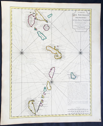
1725 Delisle Large Antique Map The West Indies - Antilles, Guadeloupe to Granada
- Title : Carte Des Antilles Francois et des Isles Voisines....
- Ref #: 61038
- Size: 25 1/2in x 21 1/2in (650mm x 545mm)
- Date : 1725
- Condition: (A+) Fine Condition
Description:
This large beautifully hand coloured original antique map of The West Indian Islands of the Antilles - from Guadeloupe to Granada - by Guillaume de L'Isle was published by Covens & Mortier in 1725 .
Condition Report
Paper thickness and quality: - Heavy and stable
Paper color: - Off white
Age of map color: - Original
Colors used: - Yellow, green, pink
General color appearance: - Authentic
Paper size: - 25 1/2in x 21 1/2in (650mm x 545mm)
Plate size: - 23 1/2in x 18in (600mm x 460mm)
Margins: - min. 1in (25mm)
Imperfections:
Margins: - Light age toning in margins
Plate area: - None
Verso: - None
Background: This map covers the predominately French portion of the West Indies from Guadeloupe to Grenada, including the Grenadines, St. Vincent, Dominica, St. Lucia (Alouise), Barbados, Martinique, and Marie-Galante, among others.
As the title cartouche suggests, Delisle cartographically derived this map almost exclusively from a manuscript produced by Thimothee Peitit, 'Arpenteur Jure de la Martinique' (Royal Surveyor of Martinique). Petit had the challenging task of reconciling local surveys of various islands with the general geography of the West Indies. Delisle copied from Petit's manuscript almost verbatim, a fact that is poignantly illustrated in the erroneous positioning of Grenada, which is both upside-down and situated to the west, rather than to the south, of the lower Grenadines. On Petit's part, this error has been attributed to simply running out of paper combined with an attempt to show the French Antilles within the greater continuity of the Windward Isles. For Delisle this was a major and uncharacteristic misstep that earned considerable critique in scientific and cartographic circles. Nonetheless, this map proved both popular and influential, being slavishly copied extensively by other cartographers of the period (Ref: M&B; Tooley)
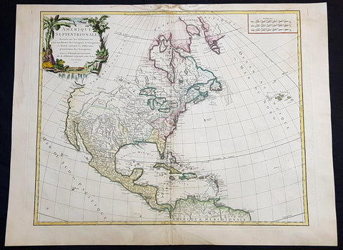
1750 Robert De Vaugondy Large Antique Map of Colonial North America, 1st Edition
- Title : Amérique Septentrionale, dressée, sur les Relations les plus modernes des Voyageurs et Navigateurs, et divisée suivant les differentes possessions des Européens...Par Le Sr Robert De Vaugondy 1750 [North America, drawn from the most recent accounts of the Voyagers and Navigators, and divided according to the different possessions of the Europeans...Robert De Vaugondy 1750
- Date : 1750
- Condition: (A+) Fine Condition
- Ref: 93358
- Size: 27 1/2in x 21in (700mm x 535mm)
Description:
This large beautifully hand coloured original 1st edition antique map of North America by Robert De Vaugondy in 1750 - dated in cartouche - was published in the 1757 edition of Atlas Universel, one of the most important atlases of the 18th century.
A beautifully executed & iconic mid 18th century antique map of the entire continent of North America, from Arctic Canada to Central America.
This map is a must for any American map collection. Beautiful original hand colour, a heavy impression (denoting an early pressing) on heavy sturdy paper with original margins, an exciting map .
General Definitions:
Paper thickness and quality: - Heavy and stable
Paper color : - off white
Age of map color: - Original
Colors used: - Yellow, green, blue, pink
General color appearance: - Authentic
Paper size: - 27 1/2in x 21in (700mm x 535mm)
Plate size: - 25in x 19 1/2in (635mm x 495mm)
Margins: - Min 1in (25mm)
Imperfections:
Margins: - Soiling in top margin
Plate area: - None
Verso: - Light age toning
Background:
This attractive map depicts a fascinating period time in the history of North America, immediately before the French and Indian War. The British Thirteen Colonies hug the Atlantic seaboard, while the immense Gallic empire, embracing both New France (Canada) and Louisiana (the Mississippi Basin) occupy the majority of the interior of the continent. This highly detailed map labels numerous native villages and European forts in the interior of the continent. Spanish Mexico reaches all the way north to modern-day Colorado, and Baja California is shown accurately to be a peninsula, and not an island as previously thought. The Pacific Northwest remains entirely enigmatic, labelled as the Terres Inconnues. The map also depicts the islands of the Caribbean, which are shown to be in the possession of the various European powers. Vaugondy consulted several sources in devising his map including Bellins excellent rendering of the Great Lakes, and Guillame De L Isles and Jean-Baptiste D\'Anvilles maps of the Mississippi Basin. The composition is graced by an elegant title cartouche featuring a waterfall inhabited by a cayman, and framed by coulisses of palm trees accompanied by native Americans.
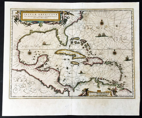
1639 Jan Jansson Antique Map of North America, Gulf of Mexico, Caribbean
- Title : Insulae Americanae in Oceano Septentrionali cum terris adiacentibus
- Date : 1639
- Condition: (A) Very Good Condition
- Ref: 43142
- Size: 22 1/2in x 18 3/4in (570mm x 475mm)
Description:
This finely engraved beautifully hand coloured original antique map of Gulf of Mexico, The Caribbean, Virginia to Florida to Texas and Central America, Venezuela was published in the 1639 French edition of Jan Jansson's Atlas Nouvs.
This map has been re-joined along the centerold and has some uplift along the centerfold and has been priced accordingly.
These maps, published in the later editions of Mercators atlas, are derived from the original maps drawn and engraved by Gerald Mercator in the mid to late 16th century, published by his son Rumold as an atlas, after his death, in 1595.
After two editions the plates were purchased by Jodocus Hondius in 1604 andcontinued to be published until the mid 1630's when the plates were re-engraved and updated by Jan Jansson and Henricus Hondius.
General Description:
Paper thickness and quality: - Heavy and stable
Paper color: - off white
Age of map color: - Original
Colors used: - Green, red, orange, yellow, blue
General color appearance: - Authentic
Paper size: - 22 1/2in x 18 3/4in (570mm x 475mm)
Plate size: - 20 1/2in x 15 1/4in (525mm x 390mm)
Margins: - Min 1in (25mm)
Imperfections:
Margins: - Light creasing
Plate area: - Light uniform age toning, centerfold re-joined with light uplift
Verso: - Light age toning
Background: Cartographically this map draws on the extremely rare chart by Hessel Gerritsz, c.1631. The area of coverage is exactly the same with the exception of the addition of the west coast of Central America. The nomenclature of the North American part is virtually identical, the only notable addition being the naming of Virginia. It reflects the firsthand knowledge of Gerritsz during his voyage to South America and the West Indies undertaken in 1628. The distance between Chesapeake Bay and Albemarle Sound is accurately portrayed at 1°; even in Gerritsz's acclaimed NOVA ANGLIA ..., for de Laet, 1630, this distance is over 2°. It seems likely that a Spanish chart was used as the nomenclature along the south-east coast lacks any of the French influences often seen at the time.(Ref: Burden; Tooley, Koeman)
1765 Isaac Tirion Original Antique Map Southern North America, Mexico, Texas GOM
- Title : Kaart Van De Onderkoningschappen van Mexico en Nieuw Granada in de Spaansche West-Indien u Amsterdam by Isaac Tirion MDCCLXV (1765)
- Date : 1765
- Size: 20in x 14 1/2in (510mm x 370mm)
- Ref #: 70708
- Condition: (A) Very Good Condition
Description:
This scarce original 1765 antique map of Southern & Central North America, Mexico, New Spain, Florida, Louisiana, GOM, Caribbean, Central America & part of South America by Isaac Tirion was engraved in 1765 - dated in title.
General Definitions:
Paper thickness and quality: - Heavy and stable
Paper color : - off white
Age of map color: -
Colors used: -
General color appearance: -
Paper size: - 20in x 14 1/2in (510mm x 370mm)
Plate size: - 19in x 12in (485mm x 305mm)
Margins: - Min 1/2in (12mm)
Imperfections:
Margins: - Left fold re-joined
Plate area: - Folds as issued, light toning along center fold
Verso: - Light toning along center fold
Background:
The history of Mexico, a country in the southern portion of North America, covers a period of more than three millennia. First populated more than 13,000 years ago, the territory had complex indigenous civilizations before being conquered and colonized by the Spanish in the 16th century. One of the important aspects of Mesoamerican civilizations was their development of a form of writing, so that Mexico's written history stretches back hundreds of years before the arrival of the Spaniards in 1519. This era before the arrival of Europeans is called variously the prehispanic era or the precolumbian era.
The Aztec capital of Tenochtitlan became the Spanish capital Mexico City, which was and remains the most populous city in Mexico.
From 1521, the Spanish conquest of the Aztec empire incorporated the region into the Spanish Empire, with New Spain its colonial era name and Mexico City the center of colonial rule. It was built on the ruins of the Aztec capital of Tenochtitlan and became the capital of New Spain. During the colonial era, Mexico's long-established Mesoamerican civilizations mixed with European culture. Perhaps nothing better represents this hybrid background than Mexico's languages: the country is both the most populous Spanish-speaking country in the world and home to the largest number of Native American language speakers in North America. For three centuries Mexico was part of the Spanish Empire, whose legacy is a country with a Spanish-speaking, Catholic and largely Western culture.
After a protracted struggle (1810–21) for independence, New Spain became the sovereign nation of Mexico, with the signing of the Treaty of Córdoba. A brief period of monarchy (1821–23), called the First Mexican Empire, was followed by the founding of the Republic of Mexico, established under a federal constitution in 1824. Legal racial categories were eliminated, abolishing the system of castas. Slavery was not abolished at independence in 1821 or with the constitution in 1824, but was eliminated in 1829. Mexico continues to be constituted as a federated republic, under the Mexican Constitution of 1917.
The Age of Santa Anna is the period of the late 1820s to the early 1850s that was dominated by criollo military-man-turned-president Antonio López de Santa Anna. In 1846, the Mexican–American War was provoked by the United States, ending two years later with Mexico ceding almost half of its territory via the Treaty of Guadalupe Hidalgo to the United States. Even though Santa Anna bore significant responsibility for the disastrous defeat, he returned to office.
The Liberal Reform began with the overthrow of Santa Anna by Mexican liberals, ushering in La Reforma beginning in 1854. The Mexican Constitution of 1857 codified the principles of liberalism in law, especially separation of church and state, equality before the law, that included stripping corporate entities (the Catholic Church and indigenous communities) of special status. The Reform sparked a civil war between liberals defending the constitution and conservatives, who opposed it. The War of the Reform saw the defeat of the conservatives on the battlefield, but conservatives remained strong and took the opportunity to invite foreign intervention against the liberals in order to forward their own cause.
The French Intervention is the period when France invaded Mexico (1861), nominally to collect on defaulted loans to the liberal government of Benito Juárez, but it went further and at the invitation of Mexican conservatives seeking to restore monarchy in Mexico set Maximilian I on the Mexican throne. The US was engaged in its own Civil War (1861–65), so did not attempt to block the foreign intervention. Abraham Lincoln consistently supported the Mexican liberals. At the end of the civil war in the US and the triumph of the Union forces, the US actively aided Mexican liberals against Maximilian's regime. France withdrew its support of Maximilian in 1867 and his monarchist rule collapsed in 1867 and Maximilian was executed.
With the end of the Second Mexican Empire, the period often called the Restored Republic (1867–76) brought back Benito Juárez as president. Following his death from a heart attack, Sebastian Lerdo de Tejada succeed him. He was overthrown by liberal military man Porfirio Diaz, who after consolidating power ushered in a period of stability and economic growth. The half-century of economic stagnation and political chaos following independence ended.
1861 US Coast Survey Large Antique Civil War Map of New York City & Surrounding Areas
- Title : Coast Chart No 21 New York Bay and Harbor New York From a Trigonometrical Survey under the direction of A D Bache Superintendant of the Survey of the Coast of the United States....1861
- Size: 33in x 28 1/2in (840mm x 720mm)
- Condition: (A) Very Good Condition
- Date : 1861
- Ref #: 93024
Description:
This large scarce, original lithograph very important antique map of New York City and surrounding area, by Alexander Dallas Bache (great-grandson of Benjamin Franklin) in 1861 - dated - was published by the official chart-maker of the United States, the office of The US Coast Survey.
An incredibly important map in light of the civil war that was raging at the time of publishing.
The Office of the Coast Survey, founded in 1807 by President Thomas Jefferson and Secretary of Commerce Albert Gallatin, is the oldest scientific organization in the U.S. Federal Government. Jefferson created the Survey of the Coast, as it was then called, in response to a need for accurate navigational charts of the new nation\\\'s coasts and harbors.
General Definitions:
Paper thickness and quality: - Heavy and stable
Paper color : - off white
Age of map color: -
Colors used: -
General color appearance: -
Paper size: - 33in x 28 1/2in (840mm x 720mm)
Plate size: - 33in x 28 1/2in (840mm x 720mm)
Margins: - Min 1/2in (12mm)
Imperfections:
Margins: - None
Plate area: - Folds as issued
Verso: - Some folds re-enforced with archival tape
Background:
A rare 1861 U.S Coast Survey chart of New York City, it\'s harbor, and environs. One of the first 19th century carts to depicts New York City as we know it today, including Manhattan, Queens, Brooklyn, the Bronx and Staten Island. Also includes Jersey City, Newark and Hoboken. This is a mid-point chart in the development of this particular series. In-land details are not as comprehensive as in later charts, most particularly the 1866 series, however remains quite thorough especially with regard to developing towns and communities. In addition to inland details, this chart contains a wealth of practical information for the mariner from oceanic depths, to harbors and navigation tips on important channels. Map also includes tables of light houses and beacons, tides and magnetic declination as well as detailed sailing instructions. The triangulation for this chart was prepared by J. Ferguson and E. Blunt. The topography by H. L. Whiting, S. A. Gilbert, A. M Harrison, F. W. Door, C. Rockwell and J. M E. Chan. The hydrography was accomplished by R. Wainwright and T. A. Craven. The entire production was supervised by A. D. Bache, Superintendent of the Survey of the Coast of the United States and one of the most influential American cartographers of the 19th century.
The Civil War, as commonly known, took place in 1861-1865, although the crises that led to the war preceded the battles by decades. The many roles played by the U.S. Coast Survey in the war can best be considered by looking at four periods: (1) The Coast Survey under Bache before the war (1843-1858) (2) The Coast Survey prepares for war (1858-1861) (3) The Coast Survey in battle (1861-1865) (4) The aftermath of the war and the transition after Bache’s death (1865-1867)....read more
The Office of Coast Survey is the official chart-maker of the United States. Set up in 1807, it is one of the U.S. governments oldest scientific organizations. In 1878 it was given the name of Coast and Geodetic Survey (C&GS). In 1970 it became part of the National Oceanic and Atmospheric Administration (NOAA).
The agency was established in 1807 when President Thomas Jefferson signed the document entitled An act to provide for surveying the coasts of the United States. While the bills objective was specific—to produce nautical charts—it reflected larger issues of concern to the new nation: national boundaries, commerce, and defence.
The early years were difficult. Ferdinand Rudolph Hassler, who was eventually to become the agencys first superintendent, went to England to collect scientific instruments but was unable to return through the duration of the War of 1812. After his return, he worked on a survey of the New York Harbor in 1817, but Congress stepped in to suspend the work because of tensions between civilian and military control of the agency. After several years under the control of the U.S. Army, the Survey of the Coast was reestablished in 1832, and President Andrew Jackson appointed Hassler as superintendent.
The U.S. Coast Survey was a civilian agency but, from the beginning, members of the Navy and Army were detailed to service with the Survey, and Navy ships were also detailed to its use. In general, army officers worked on topographic surveys on the land and maps based on the surveys, while navy officers worked on hydrographic surveys in coastal waters.
Alexander Dallas Bache, great-grandson of Benjamin Franklin, was the second Coast Survey superintendent. Bache was a physicist, scientist, and surveyor who established the first magnetic observatory and served as the first president of the National Academy of Sciences. Under Bache, Coast Survey quickly applied its resources to the Union cause during the Civil War. In addition to setting up additional lithographic presses to produce the thousands of charts required by the Navy and other vessels, Bache made a critical decision to send Coast Survey parties to work with blockading squadrons and armies in the field, producing hundreds of maps and charts. Bache detailed these activities in his annual reports to Congress.
Coast Survey cartographer Edwin Hergesheimer created the map showing the density of the slave population in the Southern states.
Bache was also one of four members of the governments Blockade Strategy Board, planning strategy to essentially strangle the South, economically and militarily. On April 16, 1861, President Lincoln issued a proclamation declaring the blockade of ports from South Carolina to Texas. Baches Notes on the Coast provided valuable information for Union naval forces.
Maps were of paramount importance in wartime:
It is certain that accurate maps must form the basis of well-conducted military operations, and that the best time to procure them is not when an attack is impending, or when the army waits, but when there is no hindrance to, or pressure upon, the surveyors. That no coast can be effectively attacked, defended, or blockaded without accurate maps and charts, has been fully proved by the events of the last two years, if, indeed, such a proposition required practical proof.
— Alexander Dallas Bache, 1862 report.
Coast Survey attracted some of the best and brightest scientists and naturalists. It commissioned the naturalist Louis Agassiz to conduct the first scientific study of the Florida reef system. James McNeill Whistler, who went on to paint the iconic Whistlers Mother, was a Coast Survey engraver. The naturalist John Muir was a guide and artist on Survey of the 39th Parallel across the Great Basin of Nevada and Utah.
The agencys men and women (women professionals were hired as early as 1845) led scientific and engineering activities through the decades. In 1926, they started production of aeronautical charts. During the height of the Great Depression, Coast and Geodetic Survey organized surveying parties and field offices that employed over 10,000 people, including many out-of-work engineers.
In World War II, C&GS sent over 1,000 civilian members and more than half of its commissioned officers to serve as hydrographers, artillery surveyors, cartographers, army engineers, intelligence officers, and geophysicists in all theaters of the war. Civilians on the home front produced over 100 million maps and charts for the Allied Forces. Eleven members of the C&GS gave their lives during the war.
Alexander Dallas Bache 1806 – 1867 was an American physicist, scientist, and surveyor who erected coastal fortifications and conducted a detailed survey to map the mid-eastern United States coastline. Originally an army engineer, he later became Superintendent of the U.S. Coast Survey, and built it into the foremost scientific institution in the country before the Civil War.
Alexander Bache was born in Philadelphia, the son of Richard Bache, Jr., and Sophia Burrell Dallas Bache. He came from a prominent family as he was the nephew of Vice-President George M. Dallas and naval hero Alexander J. Dallas. He was the grandson of Secretary of the Treasury Alexander Dallas and was the great-grandson of Benjamin Franklin.
Bache was a professor of natural philosophy and chemistry at the University of Pennsylvania from 1828 to 1841 and again from 1842 to 1843. He spent 1836–1838 in Europe on behalf of the trustees of what became Girard College; he was named president of the college after his return. Abroad, he examined European education systems, and on his return he published a valuable report. From 1839 to 1842, he served as the first president of Central High School of Philadelphia, one of the oldest public high schools in the United States.
In 1843, on the death of Professor Ferdinand Rudolph Hassler, Bache was appointed superintendent of the United States Coast Survey. He convinced the United States Congress of the value of this work and, by means of the liberal aid it granted, he completed the mapping of the whole coast by a skillful division of labor and the erection of numerous observing stations. In addition, magnetic and meteorological data were collected. Bache served as head of the Coast Survey for 24 years (until his death).
1843 James Hall Large Antique Geological Map of the United States & Great Lakes
- Title : Geological Map of the Middle and Western States by James Hall
- Date : 1843
- Size: 32 1/2in x 24in (825mm x 610mm)
- Ref #: 93061
- Condition: (A+) Fine Condition
Description:
This large original steel plate engraved, hand coloured antique Geological map from the Mississippi River to the Atlantic Ocean and from the Straits of Michilimackinac (Michillimaoinac) and Montreal, Canada to Virginia, Kentucky, and Missouri by James Hall was published in the 1843 edition of Halls Geology of New York. Part IV. Comprising the Survey of the Fourth Geological District
General Definitions:
Paper thickness and quality: - Heavy and stable
Paper color : - off white
Age of map color: - Original
Colors used: - Yellow, green, blue, pink
General color appearance: - Authentic
Paper size: - 32 1/2in x 24in (825mm x 610mm)
Plate size: - 32 1/2in x 24in (825mm x 610mm)
Margins: - Min 1/2in (12mm)
Imperfections:
Margins: - None
Plate area: - None
Verso: - None
Background:
The New York System of Geology
Hall’s map can be regarded as a landmark work as it was one of the earliest known maps to employ the New York System, of stratigraphic nomenclature developed by Hall and others at the New York Geological Survey. The system emphasized the importance of paleontology for delineating geological units and introduced the concept of type locality, a primary reference location used for defining the characteristics of geological formations. This map is the first regional application of the system, which evolved into the standard nomenclature used today for North America and much of the rest of the world.
Hall, James 1811 - 1898
Hall was an American paleontologist and geologist. Born in Hingham, Massachusetts, Hall was the oldest of four children born to James Hall Sr. and Sousanna Dourdain Hall, who had emigrated from England two years earlier. Hall attended the Rensselaer Polytechnic Institute, from which he graduated with honors in 1832 and he received a masters degree from the same institution the following year. After completing his masters degree, Hall stayed at Rensselaer and taught chemistry and later geology. In 1836, Hall was appointed to the team working on a geological and natural history of New York. That first year he was assigned as Ebenezer Emmonss assistant, for who he studied iron deposits in the Adirondack Mountains. The following year, after the survey was reorganized, Hall was put in charge of the Fourth District, in western New York. After completing the survey in 1841, Hall was named the first state paleontologist of New York. Hall published the findings of the survey in 1843 as Geology of New York Part IV. This work received much acclaim and became a classic in the field. Thanks to this success, Hall had established a solid reputation and spent the rest of his life studying stratigraphic geology and invertebrate paleontology. Hall constructed a laboratory in Albany, New York, which quickly became an important institution for aspiring geologists and paleontologists to study and train. Today, this laboratory is known as the James Hall Office and was designated a National Historic Landmark in 1976. Following the survey of New York, Hall participated in a geological survey of northern Michigan and Wisconsin in 1850, and served as state geologist for Iowa from 1855 until 1858 and for Wisconsin from 1857 until 1860. In 1866, Hall was appointed the director of the New York State Museum of Natural History in Albany, and was appointed State Geologist of New York in 1893. Hall was a founding member of the National Academy of Sciences and served as the first president of the Geological Society of America. In 1838, Hall married Sarah Aikin, with whom he had two daughters and two sons. Sarah passed away in 1895.
Endicott and Company (fl. c. 1828 - 1891) was a New York based family run lithography firm that flourished throughout the 19th century. The firm was founded by George and William Endicott, brothers who were born in Canton, Massachusetts. George Endicott (June 14, 1802 - 1848) trained as a lithographer under Pendleton Lithography from January of 1826. He later worked as superintendent of Senefelder Company until the summer of 1828. Afterwards, in 1830, he relocated to Baltimore and partnered with Moses Swett. Endicott and Swett relocated to New York City in December of 1831. They remained partners until July of 1834 when the relationship dissolved. George set up shop on his own account at 359 Broadway. William Endicott (1815 - 1851), Georges younger brother of 14 years, joined the firm in 1840 and was made a partner in 1845, after which the name of the firm was changed to G. and W. Endicott. George Endicott died shortly afterward, in 1848, but William continued operating the firm as William Endicott and Co. until his own 1851 death at just 35 years. The firm was carried on by his widow Sara Munroe Endicott until it was taken over by her son, Francis Endicott, who ran the firm from 1852 to 1886. George Endicott, Jr. subsequently ran the firm from 1887 to 1891. Peters, in his important work on American lithography America on Stone writes it is hard to summarize the Endicotts. They did everything and did it well . . . [they] worked with and for Currier and Ives, yet in spite of all that much of their work lacks real individuality. The Endicott firm was responsible for many 19th century views and plans of New York City and state as well as plans of Sacramento, California, and the Midwest.
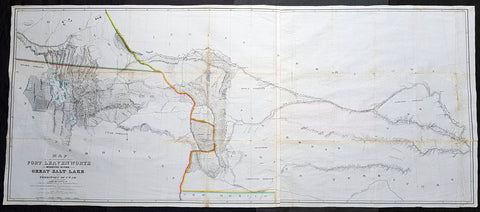
1852 Howard Stansbury Large Antique Map Forth Leavenworth, KS to Salt Lake, Utah
- Title : Map of a reconnaissance between Fort Leavenworth on the Missouri River, and the Great Salt Lake in the territory of Utah / made in 1849 and 1850 under the orders of Col. J.J. Abert, Chief of the Topographical Bureau, by Capt. Howard Stansbury of the Corps of Topographical Engineers, aided by Lieut. J.W. Gunnison, Corps Topographical Engineers, and Albert Carrington ; drawn by Lieut. Gunnison and Charles Preuss
- Size: 70in x 30in (1.78m x 760mm)
- Condition: (A) Very Good Condition
- Date : 1852
- Ref #: 93342
Description:
This large original antique lithograph map from Fort Leavenworth, Kansas to the Great Salt Lake, Utah by Howard Stansbury, in 1849-50, is one of the earliest concise and complete survey of the 900+ miles across unknown and hostile Indian territory. This is a milestone of American cartography showing detail of the territories of Nebraska, Colorado and Utah.
This large map along with another, of The Great Salt Lake in Utah, was drawn by Henry Gunnison & Charles and published by the publishing house Ackermann, New York City in 1852.
Stansbury was commissioned by Congress to survey the Great Salt Lake in the Utah Valley in 1849. Heading west using old known tracks and local knowledge, Stansbury along with his expedition, completed the task in 2 years presenting their report, along with two very large maps, to Congress in 1852.
General Definitions:
Paper thickness and quality: - Heavy and stable
Paper color : - off white
Age of map color: - Original
Colors used: - Blue
General color appearance: - Authentic
Paper size: - 70in x 30in (1.78m x 760mm)
Plate size: - 70in x 30in (1.78m x 760mm)
Margins: - Min 1/2in (12mm)
Imperfections:
Margins: - None
Plate area: - Folds as issued, small repair along a couple of folds, slight loss, light age toning
Verso: - Re-enforced along folds with transparent archival tape
Background:
In 1849 Stansbury was ordered to travel from Fort Leavenworth, Kansas to survey the Great Salt Lake in Utah, evaluate emigration trails along the way, especially the Oregon and Mormon trails and to scout for possible locations for a transcontinental railroad. The expedition consisted of 18 men including his second in command Lieutenant John Williams Gunnison. Over the following two years, the expedition explored the Great Salt Lake, Utah Lake and the Cache Valley of northern Utah all the way to Fort Hall in southern Idaho. Upon first arriving in Utah the Mormon leaders were worried that the expedition was part of an effort by the U.S government to oust the Mormon settlers. Stansbury held a meeting with Brigham Young where he assured the leader that the expedition was purely a scientific one. Young responded by assigning his personal secretary Albert Carrington to assist the expedition. Upon completing the mission in Utah, the expedition started back east to Leavenworth. Rather than follow the standard Oregon Trail route from Fort Bridger over South Pass through the Sweetwater River valley, Stansbury wanted to scout a more direct route east. Following the advice of Jim Bridger and local trappers and traders the expedition followed the Blacks Fork River east, crossed the Green River near the present day town of Green River, Wyoming and proceeded east along the Bitter Creek valley, crossing the Red Desert, and skirting the northern side of Elk Mountain across the Laramie Plains. They passed over the Laramie Mountains and made their way to Fort Laramie where they struck the Oregon Trail heading east. Stansbury's seminal 1852 map of the Great Salt Lake region in Utah is considered to be the first accurate survey of the Great Basin as well as a cornerstone achievement in the mapping of the American West. The first westerner to visit the Great Basin was most likely Silvestre Vélez de Escalante in the 1776, however, Escalante, who visited Utah Lake to the south, never truly laid eyes on Great Salt Lake. That honor would fall to unnamed trappers and mountain men travelling the region
Stansbury, Howard 1806 - 1863
Stansbury was an important surveyor, cartographer, and explorer who did his most important work in Utah during the middle part of the 19th century. Born in New York City, Stansbury trained to be a Civil Engineer. Shorty after getting married to Helen Moody of Detroit in 1827, Stansbury took a position with the United States Topographical Bureau. Under that organization he surveyed the James River in 1836, and the Illinois and Kaskaskia Rivers in 1837. In 1838, he oversaw the construction of a road from Milwaukee to the Mississippi River. Later in 1838, when the U.S Corps of Topographical Engineers was created, he joined as a first Lieutenant. With the Topographical Engineers he surveyed the Great Lakes, the harbor of Portsmouth, New Hampshire, and constructed Florida\\\'s Carysfort Reef Lighthouse. During the Mexican-American War he constructed fortification in the Dry Tortugas at the westernmost point on the Florida Keys. Upon achieving the rank of Captain, Stansbury received a commissioned to head a survey of the Great Basin that would ultimately become the crowning achievement of his career. His assignment was to survey the emigrant trails to California, including the Oregon Trail, as well as the Great Salt Lake, and report on the status of the growing Mormon Community in Salt Lake City. Working with J. W. Gunnison and Alfred Carrington, a Mormon scout, Stansbury produced a masterful survey of the region that had a lasting effect not only on the development of the Great Basin, but on the development of the west in general. Upon completion of his survey, Stansbury set out on the road to Washington, completing another important survey in the process. On the way, he fell off his horse, taking an injury from which he never fully recovered. Following the presentation of his report to Congress, Stansbury was charged with additional survey work around the Great Lakes. Upon the outbreak of the American Civil War, he was assigned to recruitment duties in Ohio and later Wisconsin. Shortly after starting work at this post he suffered an abrupt heart attack and passed away. He is buried in St. Paul, Minnesota.
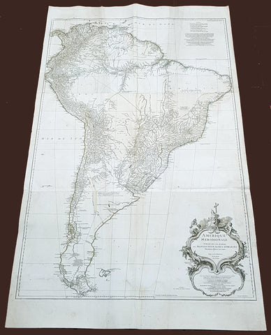
1768 D Anville Large Antique Map of South America
- Title : Amerique Meridionale Publiee Sous Les Auspices...Sr D Anville MDCCXLVIII
- Size: 55in x 32in (1.40m x 810mm)
- Condition: (A) Very Good Condition
- Date : 1768 (dated)
- Ref #: 92329
Description:
This very large original copper plate engraved antique map of South America was engraved in 1768 by William Delahaye - dated in the tile cartouche - and was published in Jean-Baptiste Bourguinon D Anvilles large elephant folio atlas Atlas Generale.
General Definitions:
Paper thickness and quality: - Heavy and stable
Paper color : - off white
Age of map color: -
Colors used: -
General color appearance: -
Paper size: - 55in x 32in (1.40m x 810mm)
Plate size: - 49in x 30 1/2in (1.30m x 770mm)
Margins: - Min 1in (25mm)
Imperfections:
Margins: - Creasing, light soiling
Plate area: - Creasing, light soiling
Verso: - Creasing, light soiling
Background:
In 1494, Portugal and Spain, the two great maritime European powers of that time, on the expectation of new lands being discovered in the west, signed the Treaty of Tordesillas, by which they agreed, with the support of the Pope, that all the land outside Europe should be an exclusive duopoly between the two countries.
The treaty established an imaginary line along a north-south meridian 370 leagues west of the Cape Verde Islands, roughly 46° 37W. In terms of the treaty, all land to the west of the line (known to comprise most of the South American soil) would belong to Spain, and all land to the east, to Portugal. As accurate measurements of longitude were impossible at that time, the line was not strictly enforced, resulting in a Portuguese expansion of Brazil across the meridian.
Beginning in the 1530s, the people and natural resources of South America were repeatedly exploited by foreign conquistadors, first from Spain and later from Portugal. These competing colonial nations claimed the land and resources as their own and divided it in colonies.
European infectious diseases (smallpox, influenza, measles, and typhus) – to which the native populations had no immune resistance – caused large-scale depopulation of the native population under Spanish control. Systems of forced labor, such as the haciendas and mining industrys mita also contributed to the depopulation. After this, African slaves, who had developed immunities to these diseases, were quickly brought in to replace them.
The Spaniards were committed to converting their native subjects to Christianity and were quick to purge any native cultural practices that hindered this end; however, many initial attempts at this were only partially successful, as native groups simply blended Catholicism with their established beliefs and practices. Furthermore, the Spaniards brought their language to the degree they did with their religion, although the Roman Catholic Churchs evangelization in Quechua, Aymara, and Guaraní actually contributed to the continuous use of these native languages albeit only in the oral form.
Eventually, the natives and the Spaniards interbred, forming a mestizo class. At the beginning, many mestizos of the Andean region were offspring of Amerindian mothers and Spanish fathers. After independence, most mestizos had native fathers and European or mestizo mothers.
Many native artworks were considered pagan idols and destroyed by Spanish explorers; this included many gold and silver sculptures and other artifacts found in South America, which were melted down before their transport to Spain or Portugal. Spaniards and Portuguese brought the western European architectural style to the continent, and helped to improve infrastructures like bridges, roads, and the sewer system of the cities they discovered or conquered. They also significantly increased economic and trade relations, not just between the old and new world but between the different South American regions and peoples. Finally, with the expansion of the Portuguese and Spanish languages, many cultures that were previously separated became united through that of Latin American.
Guyana was first a Dutch, and then a British colony, though there was a brief period during the Napoleonic Wars when it was colonized by the French. The country was once partitioned into three parts, each being controlled by one of the colonial powers until the country was finally taken over fully by the British.
The European Peninsular War (1807–1814), a theater of the Napoleonic Wars, changed the political situation of both the Spanish and Portuguese colonies. First, Napoleon invaded Portugal, but the House of Braganza avoided capture by escaping to Brazil. Napoleon also captured King Ferdinand VII of Spain, and appointed his own brother instead. This appointment provoked severe popular resistance, which created Juntas to rule in the name of the captured king.
Many cities in the Spanish colonies, however, considered themselves equally authorized to appoint local Juntas like those of Spain. This began the Spanish American wars of independence between the patriots, who promoted such autonomy, and the royalists, who supported Spanish authority over the Americas. The Juntas, in both Spain and the Americas, promoted the ideas of the Enlightenment. Five years after the beginning of the war, Ferdinand VII returned to the throne and began the Absolutist Restoration as the royalists got the upper hand in the conflict.
The independence of South America was secured by Simón Bolívar (Venezuela) and José de San Martín (Argentina), the two most important Libertadores. Bolívar led a great uprising in the north, then led his army southward towards Lima, the capital of the Viceroyalty of Peru. Meanwhile, San Martín led an army across the Andes Mountains, along with Chilean expatriates, and liberated Chile. He organized a fleet to reach Peru by sea, and sought the military support of various rebels from the Vice-royalty of Peru. The two armies finally met in Guayaquil, Ecuador, where they cornered the Royal Army of the Spanish Crown and forced its surrender.
In the Portuguese Kingdom of Brazil, Dom Pedro I (also Pedro IV of Portugal), son of the Portuguese King Dom João VI, proclaimed the independent Kingdom of Brazil in 1822, which later became the Empire of Brazil. Despite the Portuguese loyalties of garrisons in Bahia, Cisplatina and Pará, independence was diplomatically accepted by the crown in Portugal in 1825, on condition of a high compensation paid by Brazil mediatized by the United Kingdom.
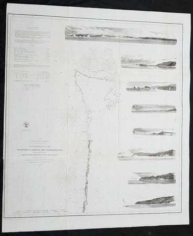
1855 US Coast Survey Large Antique Map NW Coast of America, California, Oregon
- Title : US Coast survey A D Bache Reconnaissance of the Western Coast of the United States (northern sheet) from Umpquah River to the Boundary...1855
- Size: 27 1/2in x 23 1/2in (700mm x 590mm)
- Condition: (A) Very Good Condition
- Date : 1855
- Ref #: 93032-1
Description:
This large, scarce original lithograph antique map of the US NW from the Oregon-California border northward to Vancouver Island and the Straits of Juan de Fuca, with eight coastal views, by Alexander Dallas Bache (great-grandson of Benjamin Franklin) in 1855 - dated - was published by the official chart-maker of the United States, the office of The US Coast Survey.
The Office of the Coast Survey, founded in 1807 by President Thomas Jefferson and Secretary of Commerce Albert Gallatin, is the oldest scientific organization in the U.S. Federal Government. Jefferson created the Survey of the Coast, as it was then called, in response to a need for accurate navigational charts of the new nation\\\'s coasts and harbors.
General Definitions:
Paper thickness and quality: - Heavy and stable
Paper color : - off white
Age of map color: -
Colors used: -
General color appearance: -
Paper size: - 27 1/2in x 23 1/2in (700mm x 590mm)
Plate size: - 27 1/2in x 23 1/2in (700mm x 590mm)
Margins: - Min 1/2in (12mm)
Imperfections:
Margins: - Folds as issued
Plate area: - Folds as issued
Verso: - Some folds re-enforced with archival tape
Background:
One of the most attractive coastal charts of the western United States. A rare 1855 coastal chart of the coastline of the United States Pacific Northwest, including the modern day states of Washington and Oregon. Map extends from the Oregon-California border northward to Vancouver Island and the Straits of Juan de Fuca. Features eight coastal views: \'Cape Perpetua N. by w. ½ W,\' \'Cape Lookout N. by W.,\' Tillamook Head N. by W. ½ W.,\' \'Sail Rock,\' \'Destruction Island N. W.,\' \'Flattery Rocks N.W. by N.,\' \'Tatoosh I. North,\' and \'Entrance to Columbia River, Cape Disappointment E. by N..\' Depths sounding all along the coast with various points, harbors, and lookouts well noted. Upper Left quadrant features tidal notations and sailing instructions. Inland, Steilacoom, Olympia, and Seattle are all noted on the Puget Sound. The hydrography for this region was accomplished by James Alden and the geography by G. Davidson. Published under the supervision of A. D. Bache for the 1864 Report of the Superintendent of the U.S. Coast Survey.
U.S. Coast Survey (Office of Coast Survey)
The Office of Coast Survey is the official chart-maker of the United States. Set up in 1807, it is one of the U.S. governments oldest scientific organizations. In 1878 it was given the name of Coast and Geodetic Survey (C&GS). In 1970 it became part of the National Oceanic and Atmospheric Administration (NOAA).
The agency was established in 1807 when President Thomas Jefferson signed the document entitled An act to provide for surveying the coasts of the United States. While the bills objective was specific—to produce nautical charts—it reflected larger issues of concern to the new nation: national boundaries, commerce, and defence.
The early years were difficult. Ferdinand Rudolph Hassler, who was eventually to become the agencys first superintendent, went to England to collect scientific instruments but was unable to return through the duration of the War of 1812. After his return, he worked on a survey of the New York Harbor in 1817, but Congress stepped in to suspend the work because of tensions between civilian and military control of the agency. After several years under the control of the U.S. Army, the Survey of the Coast was reestablished in 1832, and President Andrew Jackson appointed Hassler as superintendent.
The U.S. Coast Survey was a civilian agency but, from the beginning, members of the Navy and Army were detailed to service with the Survey, and Navy ships were also detailed to its use. In general, army officers worked on topographic surveys on the land and maps based on the surveys, while navy officers worked on hydrographic surveys in coastal waters.
Alexander Dallas Bache, great-grandson of Benjamin Franklin, was the second Coast Survey superintendent. Bache was a physicist, scientist, and surveyor who established the first magnetic observatory and served as the first president of the National Academy of Sciences. Under Bache, Coast Survey quickly applied its resources to the Union cause during the Civil War. In addition to setting up additional lithographic presses to produce the thousands of charts required by the Navy and other vessels, Bache made a critical decision to send Coast Survey parties to work with blockading squadrons and armies in the field, producing hundreds of maps and charts. Bache detailed these activities in his annual reports to Congress.
Coast Survey cartographer Edwin Hergesheimer created the map showing the density of the slave population in the Southern states.
Bache was also one of four members of the governments Blockade Strategy Board, planning strategy to essentially strangle the South, economically and militarily. On April 16, 1861, President Lincoln issued a proclamation declaring the blockade of ports from South Carolina to Texas. Baches Notes on the Coast provided valuable information for Union naval forces.
Maps were of paramount importance in wartime:
It is certain that accurate maps must form the basis of well-conducted military operations, and that the best time to procure them is not when an attack is impending, or when the army waits, but when there is no hindrance to, or pressure upon, the surveyors. That no coast can be effectively attacked, defended, or blockaded without accurate maps and charts, has been fully proved by the events of the last two years, if, indeed, such a proposition required practical proof.
— Alexander Dallas Bache, 1862 report.
Coast Survey attracted some of the best and brightest scientists and naturalists. It commissioned the naturalist Louis Agassiz to conduct the first scientific study of the Florida reef system. James McNeill Whistler, who went on to paint the iconic Whistlers Mother, was a Coast Survey engraver. The naturalist John Muir was a guide and artist on Survey of the 39th Parallel across the Great Basin of Nevada and Utah.
The agencys men and women (women professionals were hired as early as 1845) led scientific and engineering activities through the decades. In 1926, they started production of aeronautical charts. During the height of the Great Depression, Coast and Geodetic Survey organized surveying parties and field offices that employed over 10,000 people, including many out-of-work engineers.
In World War II, C&GS sent over 1,000 civilian members and more than half of its commissioned officers to serve as hydrographers, artillery surveyors, cartographers, army engineers, intelligence officers, and geophysicists in all theaters of the war. Civilians on the home front produced over 100 million maps and charts for the Allied Forces. Eleven members of the C&GS gave their lives during the war.
Alexander Dallas Bache 1806 – 1867 was an American physicist, scientist, and surveyor who erected coastal fortifications and conducted a detailed survey to map the mid-eastern United States coastline. Originally an army engineer, he later became Superintendent of the U.S. Coast Survey, and built it into the foremost scientific institution in the country before the Civil War.
Alexander Bache was born in Philadelphia, the son of Richard Bache, Jr., and Sophia Burrell Dallas Bache. He came from a prominent family as he was the nephew of Vice-President George M. Dallas and naval hero Alexander J. Dallas. He was the grandson of Secretary of the Treasury Alexander Dallas and was the great-grandson of Benjamin Franklin.
Bache was a professor of natural philosophy and chemistry at the University of Pennsylvania from 1828 to 1841 and again from 1842 to 1843. He spent 1836–1838 in Europe on behalf of the trustees of what became Girard College; he was named president of the college after his return. Abroad, he examined European education systems, and on his return he published a valuable report. From 1839 to 1842, he served as the first president of Central High School of Philadelphia, one of the oldest public high schools in the United States.
In 1843, on the death of Professor Ferdinand Rudolph Hassler, Bache was appointed superintendent of the United States Coast Survey. He convinced the United States Congress of the value of this work and, by means of the liberal aid it granted, he completed the mapping of the whole coast by a skillful division of labor and the erection of numerous observing stations. In addition, magnetic and meteorological data were collected. Bache served as head of the Coast Survey for 24 years (until his death).
Please note all items auctioned are genuine, we do not sell reproductions. A Certificate of Authenticity (COA) can be issued on request.
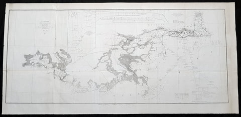
1855 US Coast Survey Large Antique Map Mississippi Delta, Louisiana to Alabama
- Title : US Coast survey A D Bache Superintendant Sketch II Showing the progress of the Survey in Section No. 8 1846-1855...1855
- Size: 35 1/2in x 17in (900mm x 430mm)
- Condition: (A) Very Good Condition
- Date : 1855
- Ref #: 93031
Description:
This large, scarce original lithograph antique map of Mississippi River Delta from Vermillion Bay Louisiana to Mobile Bay, Alabama by Alexander Dallas Bache (great-grandson of Benjamin Franklin) in 1855 - dated - was published by the official chart-maker of the United States, the office of The US Coast Survey.
The Office of the Coast Survey, founded in 1807 by President Thomas Jefferson and Secretary of Commerce Albert Gallatin, is the oldest scientific organization in the U.S. Federal Government. Jefferson created the Survey of the Coast, as it was then called, in response to a need for accurate navigational charts of the new nation\\\'s coasts and harbors.
General Definitions:
Paper thickness and quality: - Heavy and stable
Paper color : - off white
Age of map color: -
Colors used: -
General color appearance: -
Paper size: - 35 1/2in x 17in (900mm x 430mm)
Plate size: - 35 1/2in x 17in (900mm x 430mm)
Margins: - Min 1/2in (12mm)
Imperfections:
Margins: - Folds as issued
Plate area: - Folds as issued
Verso: - Some folds re-enforced with archival tape
Background:
A very attractive example of the 1855 U.S. Coast Survey nautical chart or map of the Mississippi River Delta and environs. Centered on the fanlike river delta itself, this map extends westward as far as Marsh Island and Vermillion Bay and eastward along the Mississippi Sound as far as Mobile Bay, Alabama. The course of the Mississippi River is charted as far north as New Orleans and Lake Pontchartrain. Countless triangulation points are noted throughout, particularly in Cote Blanche Bay, the Mississippi River Delta, the Mississippi Sound, and Mobile Bay. The chart was produced under the supervision of A. D. Bache, one of the most influential and prolific Superintendents of the U.S. Coast Survey.
U.S. Coast Survey (Office of Coast Survey)
The Office of Coast Survey is the official chart-maker of the United States. Set up in 1807, it is one of the U.S. governments oldest scientific organizations. In 1878 it was given the name of Coast and Geodetic Survey (C&GS). In 1970 it became part of the National Oceanic and Atmospheric Administration (NOAA).
The agency was established in 1807 when President Thomas Jefferson signed the document entitled An act to provide for surveying the coasts of the United States. While the bills objective was specific—to produce nautical charts—it reflected larger issues of concern to the new nation: national boundaries, commerce, and defence.
The early years were difficult. Ferdinand Rudolph Hassler, who was eventually to become the agencys first superintendent, went to England to collect scientific instruments but was unable to return through the duration of the War of 1812. After his return, he worked on a survey of the New York Harbor in 1817, but Congress stepped in to suspend the work because of tensions between civilian and military control of the agency. After several years under the control of the U.S. Army, the Survey of the Coast was reestablished in 1832, and President Andrew Jackson appointed Hassler as superintendent.
The U.S. Coast Survey was a civilian agency but, from the beginning, members of the Navy and Army were detailed to service with the Survey, and Navy ships were also detailed to its use. In general, army officers worked on topographic surveys on the land and maps based on the surveys, while navy officers worked on hydrographic surveys in coastal waters.
Alexander Dallas Bache, great-grandson of Benjamin Franklin, was the second Coast Survey superintendent. Bache was a physicist, scientist, and surveyor who established the first magnetic observatory and served as the first president of the National Academy of Sciences. Under Bache, Coast Survey quickly applied its resources to the Union cause during the Civil War. In addition to setting up additional lithographic presses to produce the thousands of charts required by the Navy and other vessels, Bache made a critical decision to send Coast Survey parties to work with blockading squadrons and armies in the field, producing hundreds of maps and charts. Bache detailed these activities in his annual reports to Congress.
Coast Survey cartographer Edwin Hergesheimer created the map showing the density of the slave population in the Southern states.
Bache was also one of four members of the governments Blockade Strategy Board, planning strategy to essentially strangle the South, economically and militarily. On April 16, 1861, President Lincoln issued a proclamation declaring the blockade of ports from South Carolina to Texas. Baches Notes on the Coast provided valuable information for Union naval forces.
Maps were of paramount importance in wartime:
It is certain that accurate maps must form the basis of well-conducted military operations, and that the best time to procure them is not when an attack is impending, or when the army waits, but when there is no hindrance to, or pressure upon, the surveyors. That no coast can be effectively attacked, defended, or blockaded without accurate maps and charts, has been fully proved by the events of the last two years, if, indeed, such a proposition required practical proof.
— Alexander Dallas Bache, 1862 report.
Coast Survey attracted some of the best and brightest scientists and naturalists. It commissioned the naturalist Louis Agassiz to conduct the first scientific study of the Florida reef system. James McNeill Whistler, who went on to paint the iconic Whistlers Mother, was a Coast Survey engraver. The naturalist John Muir was a guide and artist on Survey of the 39th Parallel across the Great Basin of Nevada and Utah.
The agencys men and women (women professionals were hired as early as 1845) led scientific and engineering activities through the decades. In 1926, they started production of aeronautical charts. During the height of the Great Depression, Coast and Geodetic Survey organized surveying parties and field offices that employed over 10,000 people, including many out-of-work engineers.
In World War II, C&GS sent over 1,000 civilian members and more than half of its commissioned officers to serve as hydrographers, artillery surveyors, cartographers, army engineers, intelligence officers, and geophysicists in all theaters of the war. Civilians on the home front produced over 100 million maps and charts for the Allied Forces. Eleven members of the C&GS gave their lives during the war.
Alexander Dallas Bache 1806 – 1867 was an American physicist, scientist, and surveyor who erected coastal fortifications and conducted a detailed survey to map the mid-eastern United States coastline. Originally an army engineer, he later became Superintendent of the U.S. Coast Survey, and built it into the foremost scientific institution in the country before the Civil War.
Alexander Bache was born in Philadelphia, the son of Richard Bache, Jr., and Sophia Burrell Dallas Bache. He came from a prominent family as he was the nephew of Vice-President George M. Dallas and naval hero Alexander J. Dallas. He was the grandson of Secretary of the Treasury Alexander Dallas and was the great-grandson of Benjamin Franklin.
Bache was a professor of natural philosophy and chemistry at the University of Pennsylvania from 1828 to 1841 and again from 1842 to 1843. He spent 1836–1838 in Europe on behalf of the trustees of what became Girard College; he was named president of the college after his return. Abroad, he examined European education systems, and on his return he published a valuable report. From 1839 to 1842, he served as the first president of Central High School of Philadelphia, one of the oldest public high schools in the United States.
In 1843, on the death of Professor Ferdinand Rudolph Hassler, Bache was appointed superintendent of the United States Coast Survey. He convinced the United States Congress of the value of this work and, by means of the liberal aid it granted, he completed the mapping of the whole coast by a skillful division of labor and the erection of numerous observing stations. In addition, magnetic and meteorological data were collected. Bache served as head of the Coast Survey for 24 years (until his death).
Please note all items auctioned are genuine, we do not sell reproductions. A Certificate of Authenticity (COA) can be issued on request.
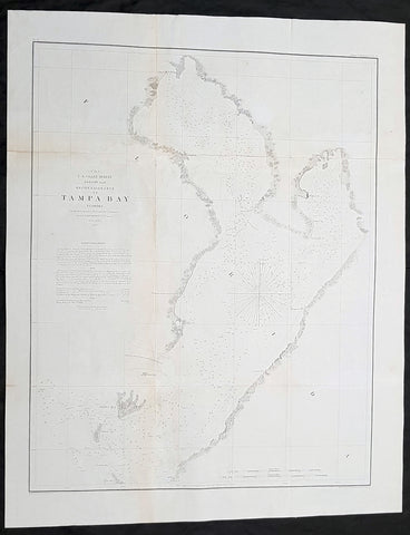
1855 US Coast Survey & AD Bache Antique Map of Tampa Bay, Florida
- Title : US Coast Survey A D Bache...Reconnaissance of Tampa Bay Florida...1855
- Size: 24in x 19 1/2in (610mm x 490mm)
- Condition: (A) Very Good Condition
- Date : 1855
- Ref #: 93019-1
Description:
This original lithograph early antique map of Tampa Bay, Florida, by Alexander Dallas Bache (great-grandson of Benjamin Franklin) in 1855 - dated - was published by the official chart-maker of the United States, the office of The US Coast Survey.
The Office of the Coast Survey, founded in 1807 by President Thomas Jefferson and Secretary of Commerce Albert Gallatin, is the oldest scientific organization in the U.S. Federal Government. Jefferson created the Survey of the Coast, as it was then called, in response to a need for accurate navigational charts of the new nation\\\'s coasts and harbors.
General Definitions:
Paper thickness and quality: - Heavy and stable
Paper color : - off white
Age of map color: -
Colors used: -
General color appearance: -
Paper size: - 24in x 19 1/2in (610mm x 490mm)
Plate size: - 24in x 19 1/2in (610mm x 490mm)
Margins: - Min 1/2in (12mm)
Imperfections:
Margins: - Folds as issued
Plate area: - Folds as issued, light age toning
Verso: - Some folds re-enforced with archival tape
.Background:
Centered on Passage Point, this map covers from St. Helena and Tampa south to Mullet Key and Palm Key. Chart notes various triangulation points and the proposed site of a rail depot on the western shore. The city of Tampa is noted though, at this stage, development is minimal. Countless depth soundings fill the bay. To the left of the map, below the title, are detailed sailing instructions and notes on tides and shoals. This is one of the earliest Coast Survey charts to focus on Tampa Bay. The hydrography for this map was completed by O. H. Berryman.
Tampa Bay was given different names by early mapmakers. Spanish maps dated from 1584 identifies Tampa Bay as Baya de Spirito Santo (Bay of the Holy Spirit). A map dated 1695 identifies the area as Bahia Tampa. Later maps dated 1794 and 1800 show the bay divided with three different names, Tampa Bay west of the Interbay peninsula and Hillsboro Bay on the east with an overall name of Bay of Spiritu Santo.
The United States acquired Florida from Spain in 1821. The name Spirito Santo seems to have disappeared from maps of the region in favor of Tampa Bay (sometimes divided into Tampa and Hillsboro Bays) soon after the US established Fort Brooke at the mouth of the Hillsborough River in 1824.
For the next 100 years, many new communities were founded around the bay. Fort Brooke begat Tampa on the northeast shore, Fort Harrison (a minor military outpost on Floridas west coast) begat Clearwater, the trading post of Bradens Town developed into Bradenton on the south, and St. Petersburg grew quickly after its founding in the late 19th century, on the western bay shore opposite Tampa.
U.S. Coast Survey (Office of Coast Survey)
The Office of Coast Survey is the official chart-maker of the United States. Set up in 1807, it is one of the U.S. governments oldest scientific organizations. In 1878 it was given the name of Coast and Geodetic Survey (C&GS). In 1970 it became part of the National Oceanic and Atmospheric Administration (NOAA).
The agency was established in 1807 when President Thomas Jefferson signed the document entitled An act to provide for surveying the coasts of the United States. While the bills objective was specific—to produce nautical charts—it reflected larger issues of concern to the new nation: national boundaries, commerce, and defence.
The early years were difficult. Ferdinand Rudolph Hassler, who was eventually to become the agencys first superintendent, went to England to collect scientific instruments but was unable to return through the duration of the War of 1812. After his return, he worked on a survey of the New York Harbor in 1817, but Congress stepped in to suspend the work because of tensions between civilian and military control of the agency. After several years under the control of the U.S. Army, the Survey of the Coast was reestablished in 1832, and President Andrew Jackson appointed Hassler as superintendent.
The U.S. Coast Survey was a civilian agency but, from the beginning, members of the Navy and Army were detailed to service with the Survey, and Navy ships were also detailed to its use. In general, army officers worked on topographic surveys on the land and maps based on the surveys, while navy officers worked on hydrographic surveys in coastal waters.
Alexander Dallas Bache, great-grandson of Benjamin Franklin, was the second Coast Survey superintendent. Bache was a physicist, scientist, and surveyor who established the first magnetic observatory and served as the first president of the National Academy of Sciences. Under Bache, Coast Survey quickly applied its resources to the Union cause during the Civil War. In addition to setting up additional lithographic presses to produce the thousands of charts required by the Navy and other vessels, Bache made a critical decision to send Coast Survey parties to work with blockading squadrons and armies in the field, producing hundreds of maps and charts. Bache detailed these activities in his annual reports to Congress.
Coast Survey cartographer Edwin Hergesheimer created the map showing the density of the slave population in the Southern states.
Bache was also one of four members of the governments Blockade Strategy Board, planning strategy to essentially strangle the South, economically and militarily. On April 16, 1861, President Lincoln issued a proclamation declaring the blockade of ports from South Carolina to Texas. Baches Notes on the Coast provided valuable information for Union naval forces.
Maps were of paramount importance in wartime:
It is certain that accurate maps must form the basis of well-conducted military operations, and that the best time to procure them is not when an attack is impending, or when the army waits, but when there is no hindrance to, or pressure upon, the surveyors. That no coast can be effectively attacked, defended, or blockaded without accurate maps and charts, has been fully proved by the events of the last two years, if, indeed, such a proposition required practical proof.
— Alexander Dallas Bache, 1862 report.
Coast Survey attracted some of the best and brightest scientists and naturalists. It commissioned the naturalist Louis Agassiz to conduct the first scientific study of the Florida reef system. James McNeill Whistler, who went on to paint the iconic Whistlers Mother, was a Coast Survey engraver. The naturalist John Muir was a guide and artist on Survey of the 39th Parallel across the Great Basin of Nevada and Utah.
The agencys men and women (women professionals were hired as early as 1845) led scientific and engineering activities through the decades. In 1926, they started production of aeronautical charts. During the height of the Great Depression, Coast and Geodetic Survey organized surveying parties and field offices that employed over 10,000 people, including many out-of-work engineers.
In World War II, C&GS sent over 1,000 civilian members and more than half of its commissioned officers to serve as hydrographers, artillery surveyors, cartographers, army engineers, intelligence officers, and geophysicists in all theaters of the war. Civilians on the home front produced over 100 million maps and charts for the Allied Forces. Eleven members of the C&GS gave their lives during the war.
Alexander Dallas Bache 1806 – 1867 was an American physicist, scientist, and surveyor who erected coastal fortifications and conducted a detailed survey to map the mid-eastern United States coastline. Originally an army engineer, he later became Superintendent of the U.S. Coast Survey, and built it into the foremost scientific institution in the country before the Civil War.
Alexander Bache was born in Philadelphia, the son of Richard Bache, Jr., and Sophia Burrell Dallas Bache. He came from a prominent family as he was the nephew of Vice-President George M. Dallas and naval hero Alexander J. Dallas. He was the grandson of Secretary of the Treasury Alexander Dallas and was the great-grandson of Benjamin Franklin.
Bache was a professor of natural philosophy and chemistry at the University of Pennsylvania from 1828 to 1841 and again from 1842 to 1843. He spent 1836–1838 in Europe on behalf of the trustees of what became Girard College; he was named president of the college after his return. Abroad, he examined European education systems, and on his return he published a valuable report. From 1839 to 1842, he served as the first president of Central High School of Philadelphia, one of the oldest public high schools in the United States.
In 1843, on the death of Professor Ferdinand Rudolph Hassler, Bache was appointed superintendent of the United States Coast Survey. He convinced the United States Congress of the value of this work and, by means of the liberal aid it granted, he completed the mapping of the whole coast by a skillful division of labor and the erection of numerous observing stations. In addition, magnetic and meteorological data were collected. Bache served as head of the Coast Survey for 24 years (until his death).
Please note all items auctioned are genuine, we do not sell reproductions. A Certificate of Authenticity (COA) can be issued on request.
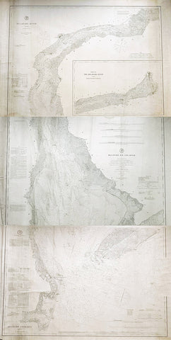
1878-88 US Coast Survey 3 x Sheet Very Large Antique Map of The Delaware River
- Title : Delaware River..Issued in June 1881 CP Paterson; Delaware Bay and River..under the direction of FR Hassler and AD Bache...April 1878 CP Patterson; Delaware Entrance aids to navigation to 1887
- Size: 42in x 29in (1.07m x 735mm) each sheet
- Condition: (B) Good Condition
- Date : 178-88
- Ref #: 93111
Description:
Original scarce very large (78in x 36in when joined) antique three sheet map, on very heavy paper, of the Delaware River and Harbour. The map follows the river bordering the States of New Jersey, Delaware & Pennsylvania, from the river mouth to Philadelphia PA, by AD Bache and FR Hassler and was first issued by the US Coast Survey in 1848. These 3 sheets were issued, updated in 1887, 1881 & 1887 respectively.
General Definitions:
Paper thickness and quality: - Heavy and stable
Paper color : - off white
Age of map color: -
Colors used: -
General color appearance: -
Paper size: - 42in x 29in (1.07m x 735mm) each sheet (approx)
Plate size: - 42in x 29in (1.07m x 735mm) each sheet (approx)
Margins: - Min 1/2in (12mm)
Imperfections:
Margins: - Soiling and creasing
Plate area: - Soiling and vertical creasing
Verso: - Soiling and vertical creasing
Background:
While these maps appear together occasionally on the market, and can be found bound into early US Coast Survey volumes, the thin paper and browned folds invariably leaves it in problematic condition. The present example is a separately issued example on very heavy paper. Many of the coast survey maps were issued in very limited numbers on heavy paper for presentation purposes or use at sea, making any example of these three maps together rare.
U.S. Coast Survey (Office of Coast Survey)
The Office of Coast Survey is the official chart-maker of the United States. Set up in 1807, it is one of the U.S. governments oldest scientific organizations. In 1878 it was given the name of Coast and Geodetic Survey (C&GS). In 1970 it became part of the National Oceanic and Atmospheric Administration (NOAA).
The agency was established in 1807 when President Thomas Jefferson signed the document entitled An act to provide for surveying the coasts of the United States. While the bills objective was specific—to produce nautical charts—it reflected larger issues of concern to the new nation: national boundaries, commerce, and defence.
The early years were difficult. Ferdinand Rudolph Hassler, who was eventually to become the agencys first superintendent, went to England to collect scientific instruments but was unable to return through the duration of the War of 1812. After his return, he worked on a survey of the New York Harbor in 1817, but Congress stepped in to suspend the work because of tensions between civilian and military control of the agency. After several years under the control of the U.S. Army, the Survey of the Coast was reestablished in 1832, and President Andrew Jackson appointed Hassler as superintendent.
The U.S. Coast Survey was a civilian agency but, from the beginning, members of the Navy and Army were detailed to service with the Survey, and Navy ships were also detailed to its use. In general, army officers worked on topographic surveys on the land and maps based on the surveys, while navy officers worked on hydrographic surveys in coastal waters.
Alexander Dallas Bache, great-grandson of Benjamin Franklin, was the second Coast Survey superintendent. Bache was a physicist, scientist, and surveyor who established the first magnetic observatory and served as the first president of the National Academy of Sciences. Under Bache, Coast Survey quickly applied its resources to the Union cause during the Civil War. In addition to setting up additional lithographic presses to produce the thousands of charts required by the Navy and other vessels, Bache made a critical decision to send Coast Survey parties to work with blockading squadrons and armies in the field, producing hundreds of maps and charts. Bache detailed these activities in his annual reports to Congress.
Coast Survey cartographer Edwin Hergesheimer created the map showing the density of the slave population in the Southern states.
Bache was also one of four members of the governments Blockade Strategy Board, planning strategy to essentially strangle the South, economically and militarily. On April 16, 1861, President Lincoln issued a proclamation declaring the blockade of ports from South Carolina to Texas. Baches Notes on the Coast provided valuable information for Union naval forces.
Maps were of paramount importance in wartime:
It is certain that accurate maps must form the basis of well-conducted military operations, and that the best time to procure them is not when an attack is impending, or when the army waits, but when there is no hindrance to, or pressure upon, the surveyors. That no coast can be effectively attacked, defended, or blockaded without accurate maps and charts, has been fully proved by the events of the last two years, if, indeed, such a proposition required practical proof.
— Alexander Dallas Bache, 1862 report.
Coast Survey attracted some of the best and brightest scientists and naturalists. It commissioned the naturalist Louis Agassiz to conduct the first scientific study of the Florida reef system. James McNeill Whistler, who went on to paint the iconic Whistlers Mother, was a Coast Survey engraver. The naturalist John Muir was a guide and artist on Survey of the 39th Parallel across the Great Basin of Nevada and Utah.
The agencys men and women (women professionals were hired as early as 1845) led scientific and engineering activities through the decades. In 1926, they started production of aeronautical charts. During the height of the Great Depression, Coast and Geodetic Survey organized surveying parties and field offices that employed over 10,000 people, including many out-of-work engineers.
In World War II, C&GS sent over 1,000 civilian members and more than half of its commissioned officers to serve as hydrographers, artillery surveyors, cartographers, army engineers, intelligence officers, and geophysicists in all theaters of the war. Civilians on the home front produced over 100 million maps and charts for the Allied Forces. Eleven members of the C&GS gave their lives during the war.
Alexander Dallas Bache 1806 – 1867 was an American physicist, scientist, and surveyor who erected coastal fortifications and conducted a detailed survey to map the mid-eastern United States coastline. Originally an army engineer, he later became Superintendent of the U.S. Coast Survey, and built it into the foremost scientific institution in the country before the Civil War.
Alexander Bache was born in Philadelphia, the son of Richard Bache, Jr., and Sophia Burrell Dallas Bache. He came from a prominent family as he was the nephew of Vice-President George M. Dallas and naval hero Alexander J. Dallas. He was the grandson of Secretary of the Treasury Alexander Dallas and was the great-grandson of Benjamin Franklin.
Bache was a professor of natural philosophy and chemistry at the University of Pennsylvania from 1828 to 1841 and again from 1842 to 1843. He spent 1836–1838 in Europe on behalf of the trustees of what became Girard College; he was named president of the college after his return. Abroad, he examined European education systems, and on his return he published a valuable report. From 1839 to 1842, he served as the first president of Central High School of Philadelphia, one of the oldest public high schools in the United States.
In 1843, on the death of Professor Ferdinand Rudolph Hassler, Bache was appointed superintendent of the United States Coast Survey. He convinced the United States Congress of the value of this work and, by means of the liberal aid it granted, he completed the mapping of the whole coast by a skillful division of labor and the erection of numerous observing stations. In addition, magnetic and meteorological data were collected. Bache served as head of the Coast Survey for 24 years (until his death).
Please note all items auctioned are genuine, we do not sell reproductions. A Certificate of Authenticity (COA) can be issued on request.
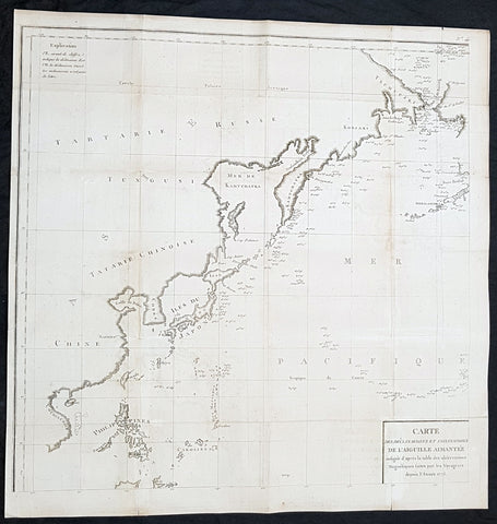
1775 La Perouse Antique Map of NW Pacific, Bering Straits to China, Philippines
- Title : Carte des Declinaisons et inclinaisons de l\'Aiguille Aimantee redigee d apres la table des observations Magnetiques faites par les Voyageurs depuis l Annee 1775
- Size: 24in x 24in (520mm x 520mm)
- Condition: (A+) Fine Condition
- Date : 1775
- Ref #: 32192
Description:
This large original copper plate engraved antique NW Pacific - from the Bering Straits to China & The Philippines - by Jean-François de Galaup, Comte de la Pérouse was engraved in 1775 and published in Count de Buffons monumental publication Histoire Naturelle
General Definitions:
Paper thickness and quality: - Heavy and stable
Paper color : - off white
Age of map color: -
Colors used: -
General color appearance: -
Paper size: - 24in x 24in (520mm x 520mm)
Plate size: - 24in x 24in (520mm x 520mm)
Margins: - Min 1/2in (12mm)
Imperfections:
Margins: - None
Plate area: - Folds as issued, light toning along folds
Verso: - None
Background:
This map is one of 8 charts which records the first detailed & documented the earths magnetism. Compiled from the reports of La Perouse last voyage in the Pacific.
An uncommon chart designed to display magnetic variation in the Pacific, published in Count de Buffons Histoire Naturelle, in the mineralogy volumes. As this section was not as popular as the bird volumes it is believed that only 250 copies of this edition were printed.
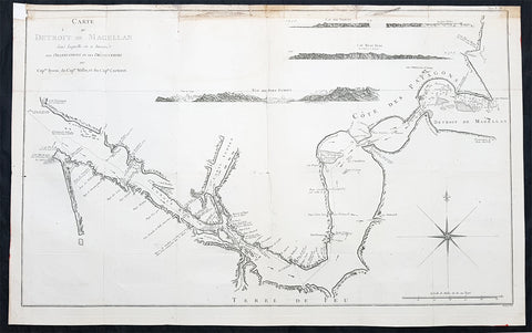
1774 Hawkesworth Large Antique Map Chart of The Magellan Straits, South America
- Title : Carte Du Detroit De Magellan dans laquelle on a Insere Les Observations et Les Decouvertes Du Capne Byron, du Capne Wallis, et du Capne Carteret
- Ref : 32219
- Size: 30 1/2in x 21 1/2in (775mm x 545mm)
- Date : 1774
- Condition: (A) Very Good Condition
Description:
This large, original copper-plate engraved, antique map, a chart of the Straits of Magellan, South America and the Patagonian & South Chilean shoreline was engraved by Robert Benard and published in the 1774 French edition of John Hawkesworths An Account of the Voyages Undertaken by the Order of His Present Majesty for Making Discoveries in the Southern Hemisphere and Successively Performed by Commodore Byron, Captain Wallis, Captain Carteret, and Captain Cook, in the Dolphin, the Swallow, and the Endeavor, Drawn Up from the Journals Which Were Kept by the Several Commanders, and from the Papers of Joseph Banks
A large scale chart with detailed shoreline topography, channels, soundings, shoals, harbors and small islands. There are also anchorages, capes & bays as well as 4 finely engraved landfall approach views of
1.Vue Du Port Famine
2. Cap Beau Tems
3.Cap Des Vierges
4. Rochers blanc. (white rocks).
The tracks and some details in this chart are attributed to the following navigators;
Commodore Byron, Captain Wallis and Captain Carteret.
General Definitions:
Paper thickness and quality: - Heavy and stable
Paper color : - off white
Age of map color: - Early
Colors used: - Yellow, green, brown
General color appearance: - Authentic
Paper size: - 30 1/2in x 21 1/2in (775mm x 545mm)
Plate size: - 30in x 20in (765mm x 510mm)
Margins: - Min 1/2in (12mm)
Imperfections:
Margins: - Soiling to top margin and border, repair to top left corner
Plate area: - Folds as issued
Verso: - Folds as issued
Background:
The Strait of Magellan
(Estrecho de Magallanes) is a navigable sea route separating mainland South America to the north and Tierra del Fuego to the south. The strait is the most important natural passage between the Atlantic and Pacific oceans.
Ferdinand Magellan a Portuguese explorer and navigator in the service of Charles I of Spain, became the first European to navigate the strait in 1520 during his circumnavigation of the globe.
Other early explorers included Francis Drake (1578). In February 1696 the first French expedition, under the command of M. de Gennes reached the Strait of Magellan. The expedition is described by the young French explorer, engineer and hydrographer François Froger in his A Relation of a Voyage (1699).
The strait was first carefully explored and thoroughly charted by Phillip Parker King, who commanded the British survey vessel HMS Adventure, and in consort with HMS Beagle spent five years surveying the complex coasts around the strait (1826–1830). A report on the survey was presented at two meetings of the Geographical Society of London in 1831.
The 3 Voyages, with Captains, ships & tracks who contributed to this map are;
1. 1764-66 - HMS Dolphin under Command of Commodore John Byron, completed the first circumnavigation of the globe under two years.
2. 1766-68 - HMS Dolphin under Command of Captain Samuel Wallis, completed another circumnavigation & was the first European to visit Tahiti & the Society Islands.
3. 1766-68 - HMS Swallow under Command of Captain Philip Carteret, who accompanied HMS Dolphin under the command of Samuel Wallis to circumnavigate the world.
John Hawkesworth an English writer and journalist, Hawkesworth was commissioned by the British Admiralty to edit for publication the narratives of its officers’ circumnavigations. He was given full access to the journals of the commanders and the freedom to adapt and re-tell them in the first person. Cook was already on his way back from his second Pacific voyage, temporarily docked at Cape Town (South Africa), when he first saw the published volumes: he was mortified and furious to find that Hawkesworth claimed in the introduction that Cook had seen and blessed (with slight corrections) the resulting manuscript. (In his defense, Hawkesworth also had been a victim of misunderstanding.) Cook had trouble recognizing himself. Moreover, the work was full of errors and commentary introduced by Hawkesworth and, in Cook’s view, too full of Banks, who had promoted himself and the publication. Still, the work was popular; the first edition sold out in several months.
Robert Bénard 1734 – 1777 was an 18th-century French engraver.
Specialized in the technique of engraving, Robert Ménard is mainly famous for having supplied a significant amount of plates (at least 1,800) to the Encyclopédie by Diderot & d Alembert from 1751.
Later, publisher Charles-Joseph Panckoucke reused many of his productions to illustrate the works of his catalog.
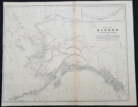
1886 US Govt. Large Scarce Antique Map of Alaska from Russian British US Sources
- Title : Map of Alaska and adjoining Regions 1886..Complied from the Russian Charts of Tebenkov, Sarychev, Lutke........
- Size: 21 1/2in x 17in (535mm x 430mm)
- Condition: (A) Good Condition
- Date : 1886
- Ref #: 31917
Description:
This large scarce original lithograph antique map of Alaska, compiled from Russian British and American sources was published in 1886 - dated.
General Definitions:
Paper thickness and quality: - Heavy and stable
Paper color : - off white
Age of map color: -
Colors used: -
General color appearance: -
Paper size: - 21 1/2in x 17in (535mm x 430mm)
Plate size: - 21 1/2in x 17in (535mm x 430mm)
Margins: - Min 1/2in (12mm)
Imperfections:
Margins: - Slight loss to top fold
Plate area: - Folds as issued, light age toning
Verso: - Folds re-enforced on verso
Background:
Some researchers believe that the first Russian settlement in Alaska was established in the 17th century. According to this hypothesis, in 1648 several koches of Semyon Dezhnyovs expedition came ashore in Alaska by storm and founded this settlement. This hypothesis is based on the testimony of Chukchi geographer Nikolai Daurkin, who had visited Alaska in 1764–1765 and who had reported on a village on the Kheuveren River, populated by bearded men who pray to the icons. Some modern researchers associate Kheuveren with Koyuk River.
The first European vessel to reach Alaska is generally held to be the St. Gabriel under the authority of the surveyor M. S. Gvozdev and assistant navigator I. Fyodorov on August 21, 1732, during an expedition of Siberian cossak A. F. Shestakov and Belarusian explorer Dmitry Pavlutsky (1729–1735).
Another European contact with Alaska occurred in 1741, when Vitus Bering led an expedition for the Russian Navy aboard the St. Peter. After his crew returned to Russia with sea otter pelts judged to be the finest fur in the world, small associations of fur traders began to sail from the shores of Siberia toward the Aleutian Islands. The first permanent European settlement was founded in 1784.
For most of Alaskas first decade under the United States flag, Sitka was the only community inhabited by American settlers. They organized a provisional city government, which was Alaskas first municipal government, but not in a legal sense. Legislation allowing Alaskan communities to legally incorporate as cities did not come about until 1900, and home rule for cities was extremely limited or unavailable until statehood took effect in 1959.
Starting in the 1890s and stretching in some places to the early 1910s, gold rushes in Alaska and the nearby Yukon Territory brought thousands of miners and settlers to Alaska. Alaska was officially incorporated as an organized territory in 1912. Alaskas capital, which had been in Sitka until 1906, was moved north to Juneau. Construction of the Alaska Governors Mansion began that same year. European immigrants from Norway and Sweden also settled in southeast Alaska, where they entered the fishing and logging industries.
1861 A D Bache Large Antique Map Napa River & Petaluma River Valleys, California
- Title : Petaluma and Napa Creeks California from a Trigonomitrical survey under the direction of A D Bache Superintendant of the Survey of the Coast of the United States....1861
- Size: 33in x 24 1/2in (840mm x 615mm)
- Condition: (A+) Fine Condition
- Date : 1861
- Ref #: 93037
Description:
This large scarce, original lithograph early antique map of Napa River Valley and Petaluma River Valley, California by Alexander Dallas Bache (great-grandson of Benjamin Franklin) in 1861 - dated - was published by the official chart-maker of the United States, the office of The US Coast Survey.
The Office of the Coast Survey, founded in 1807 by President Thomas Jefferson and Secretary of Commerce Albert Gallatin, is the oldest scientific organization in the U.S. Federal Government. Jefferson created the Survey of the Coast, as it was then called, in response to a need for accurate navigational charts of the new nation\\\'s coasts and harbors.
General Definitions:
Paper thickness and quality: - Heavy and stable
Paper color : - off white
Age of map color: -
Colors used: -
General color appearance: -
Paper size: - 33in x 24 1/2in (840mm x 615mm)
Plate size: - 33in x 24 1/2in (840mm x 615mm)
Margins: - Min 1/2in (12mm)
Imperfections:
Margins: - None
Plate area: - Folds as issued, light age toning
Verso: - Some folds re-enforced with archival tape
Background:
This is an uncommon 1861 U.S. Coast Survey nautical chart or map of the Napa River Valley and Petaluma River Valley, California. Essentially two maps on the same sheet, the left hand side of the sheet features a chart of the Petaluma Creek from Petaluma City as it empties into the San Pablo Bay. The chart on the right features the Napa Creek from Napa City to the Bay. Today this region enjoys international regard as the production center of some of the worlds finest wines.
The southern part of the Napa Creek as it empties into the San Pablo Bay between Mare Island and Vallejo is included in an inset near the bottom border and feature the Mare Island Straits. The straits, which are the mouth of the Napa River, are today popular for recreational boating and water sports.
The map offers excellent inland detail to the level of individual buildings, especially in Petaluma City, Napa City and in Vallejo and the Naval Yard. It also notes towns, roads, and inlets. Nautically this map offers a wealth of practical information for the mariner, including countless depth soundings and notes on tides, soundings and undersea dangers.
The triangulation for this chart was accomplished by G. A. Fairfield and A. F. Rodgers. The topography is the work of A. F. Rodgers and the hydrography was completed by a party under the command of James Alden. The entire work was produced in 1861 under the direction of A. D. Bache, Superintendent of the Survey of the Coast of the United States and one of the most influential American cartographers of the 19th century. Issued in the 1861 edition of the Superintendents Report.
U.S. Coast Survey (Office of Coast Survey)
The Office of Coast Survey is the official chart-maker of the United States. Set up in 1807, it is one of the U.S. governments oldest scientific organizations. In 1878 it was given the name of Coast and Geodetic Survey (C&GS). In 1970 it became part of the National Oceanic and Atmospheric Administration (NOAA).
The agency was established in 1807 when President Thomas Jefferson signed the document entitled An act to provide for surveying the coasts of the United States. While the bills objective was specific—to produce nautical charts—it reflected larger issues of concern to the new nation: national boundaries, commerce, and defence.
The early years were difficult. Ferdinand Rudolph Hassler, who was eventually to become the agencys first superintendent, went to England to collect scientific instruments but was unable to return through the duration of the War of 1812. After his return, he worked on a survey of the New York Harbor in 1817, but Congress stepped in to suspend the work because of tensions between civilian and military control of the agency. After several years under the control of the U.S. Army, the Survey of the Coast was reestablished in 1832, and President Andrew Jackson appointed Hassler as superintendent.
The U.S. Coast Survey was a civilian agency but, from the beginning, members of the Navy and Army were detailed to service with the Survey, and Navy ships were also detailed to its use. In general, army officers worked on topographic surveys on the land and maps based on the surveys, while navy officers worked on hydrographic surveys in coastal waters.
Alexander Dallas Bache, great-grandson of Benjamin Franklin, was the second Coast Survey superintendent. Bache was a physicist, scientist, and surveyor who established the first magnetic observatory and served as the first president of the National Academy of Sciences. Under Bache, Coast Survey quickly applied its resources to the Union cause during the Civil War. In addition to setting up additional lithographic presses to produce the thousands of charts required by the Navy and other vessels, Bache made a critical decision to send Coast Survey parties to work with blockading squadrons and armies in the field, producing hundreds of maps and charts. Bache detailed these activities in his annual reports to Congress.
Coast Survey cartographer Edwin Hergesheimer created the map showing the density of the slave population in the Southern states.
Bache was also one of four members of the governments Blockade Strategy Board, planning strategy to essentially strangle the South, economically and militarily. On April 16, 1861, President Lincoln issued a proclamation declaring the blockade of ports from South Carolina to Texas. Baches Notes on the Coast provided valuable information for Union naval forces.
Maps were of paramount importance in wartime:
It is certain that accurate maps must form the basis of well-conducted military operations, and that the best time to procure them is not when an attack is impending, or when the army waits, but when there is no hindrance to, or pressure upon, the surveyors. That no coast can be effectively attacked, defended, or blockaded without accurate maps and charts, has been fully proved by the events of the last two years, if, indeed, such a proposition required practical proof.
— Alexander Dallas Bache, 1862 report.
Coast Survey attracted some of the best and brightest scientists and naturalists. It commissioned the naturalist Louis Agassiz to conduct the first scientific study of the Florida reef system. James McNeill Whistler, who went on to paint the iconic Whistlers Mother, was a Coast Survey engraver. The naturalist John Muir was a guide and artist on Survey of the 39th Parallel across the Great Basin of Nevada and Utah.
The agencys men and women (women professionals were hired as early as 1845) led scientific and engineering activities through the decades. In 1926, they started production of aeronautical charts. During the height of the Great Depression, Coast and Geodetic Survey organized surveying parties and field offices that employed over 10,000 people, including many out-of-work engineers.
In World War II, C&GS sent over 1,000 civilian members and more than half of its commissioned officers to serve as hydrographers, artillery surveyors, cartographers, army engineers, intelligence officers, and geophysicists in all theaters of the war. Civilians on the home front produced over 100 million maps and charts for the Allied Forces. Eleven members of the C&GS gave their lives during the war.
Alexander Dallas Bache 1806 – 1867 was an American physicist, scientist, and surveyor who erected coastal fortifications and conducted a detailed survey to map the mid-eastern United States coastline. Originally an army engineer, he later became Superintendent of the U.S. Coast Survey, and built it into the foremost scientific institution in the country before the Civil War.
Alexander Bache was born in Philadelphia, the son of Richard Bache, Jr., and Sophia Burrell Dallas Bache. He came from a prominent family as he was the nephew of Vice-President George M. Dallas and naval hero Alexander J. Dallas. He was the grandson of Secretary of the Treasury Alexander Dallas and was the great-grandson of Benjamin Franklin.
Bache was a professor of natural philosophy and chemistry at the University of Pennsylvania from 1828 to 1841 and again from 1842 to 1843. He spent 1836–1838 in Europe on behalf of the trustees of what became Girard College; he was named president of the college after his return. Abroad, he examined European education systems, and on his return he published a valuable report. From 1839 to 1842, he served as the first president of Central High School of Philadelphia, one of the oldest public high schools in the United States.
In 1843, on the death of Professor Ferdinand Rudolph Hassler, Bache was appointed superintendent of the United States Coast Survey. He convinced the United States Congress of the value of this work and, by means of the liberal aid it granted, he completed the mapping of the whole coast by a skillful division of labor and the erection of numerous observing stations. In addition, magnetic and meteorological data were collected. Bache served as head of the Coast Survey for 24 years (until his death).
1855 A D Bache Large Antique Map of Chesapeake Bay Virginia & Maryland, USA
- Title : US Coast Survey A D Bache Supt Sketch C Showing the Progress of the Survey in Section No. III from 1843 to 1855....1855
- Size: 36in x 24 1/2in (915mm x 615mm)
- Condition: (A) Very Good Condition
- Date : 1855
- Ref #: 93032
Description:
This large scarce, original lithograph early antique map of Chesapeake Bay and Maryland by Alexander Dallas Bache (great-grandson of Benjamin Franklin) in 1855 - dated - was published by the official chart-maker of the United States, the office of The US Coast Survey.
The Office of the Coast Survey, founded in 1807 by President Thomas Jefferson and Secretary of Commerce Albert Gallatin, is the oldest scientific organization in the U.S. Federal Government. Jefferson created the Survey of the Coast, as it was then called, in response to a need for accurate navigational charts of the new nation\\\'s coasts and harbors.
General Definitions:
Paper thickness and quality: - Heavy and stable
Paper color : - off white
Age of map color: -
Colors used: -
General color appearance: -
Paper size: - 36in x 24 1/2in (915mm x 615mm)
Plate size: - 36in x 24 1/2in (915mm x 615mm)
Margins: - Min 1/2in (12mm)
Imperfections:
Margins: - None
Plate area: - Folds as issued, small repair to top fold
Verso: - Some folds re-enforced with archival tape
Background:
In 1524, Italian explorer Giovanni da Verrazzano, (1485–1528), in service of the French crown, (famous for sailing through and thereafter naming the entrance to New York Bay as the Verrazzano Narrows, including now in the 20th century, a suspension bridge also named for him) sailed past the Chesapeake, but did not enter the Bay. Spanish explorer Lucas Vásquez de Ayllón sent an expedition out from Hispaniola in 1525 that reached the mouths of the Chesapeake and Delaware Bays. It may have been the first European expedition to explore parts of the Chesapeake Bay, which the Spaniards called Bahía de Santa María (Bay of St. Mary) or Bahía de Madre de Dios.(Bay of the Mother of God) De Ayllón established a short-lived Spanish mission settlement, San Miguel de Gualdape, in 1526 along the Atlantic coast. Many scholars doubt the assertion that it was as far north as the Chesapeake; most place it in present-day Georgias Sapelo Island. In 1573, Pedro Menéndez de Márquez, the governor of Spanish Florida, conducted further exploration of the Chesapeake. In 1570, Spanish Jesuits established the short-lived Ajacan Mission on one of the Chesapeake tributaries in present-day Virginia.
The arrival of English colonists under Sir Walter Raleigh and Humphrey Gilbert in the late 16th century to found a colony, later settled at Roanoke Island (off the present-day coast of North Carolina) for the Virginia Company, marked the first time that the English approached the gates to the Chesapeake Bay between the capes of Cape Charles and Cape Henry. Three decades later, in 1607, Europeans again entered the Bay. Captain John Smith of England explored and mapped the Bay between 1607 and 1609, resulting in the publication in 1612 back in the British Isles of A Map of Virginia. Smith wrote in his journal: Heaven and earth have never agreed better to frame a place for mans habitation. The new laying out of the Captain John Smith Chesapeake National Historic Trail, the United States first designated all-water National Historic Trail, was created in July 2006, by the National Park Service of the U.S. Department of the Interior following the route of Smiths historic 17th-century voyage. Because of economic hardships and civil strife in the Mother Land, there was a mass migration of southern English Cavaliers and their servants to the Chesapeake Bay region between 1640 and 1675, to both of the new colonies of the Province of Virginia and the Province of Maryland.
The Chesapeake Bay was the site of the Battle of the Chesapeake (also known as the Battle of the Capes, Cape Charles and Cape Henry) in 1781, during which the French fleet defeated the Royal Navy in the decisive naval battle of the American Revolutionary War. The British defeat enabled General George Washington and his French allied armies under Comte de Rochambeau to march down from New York and bottle up the rampaging southern British Army of Lord Cornwallis from the North and South Carolinas at the siege of Battle of Yorktown in Yorktown, Virginia. Their marching route from Newport, Rhode Island through Connecticut, New York State, Pennsylvania, New Jersey and Delaware to the Head of Elk by the Susquehanna River along the shores and also partially sailing down the Bay to Virginia. It is also the subject of a designated National Historic Trail under the National Park Service as the Washington-Rochambeau Revolutionary Route.
The Bay would again see conflict during War of 1812. During the year of 1813, from their base on Tangier Island, British naval forces under the command of Admiral George Cockburn raided and plundered several towns on the shores of the Chesapeake, treating the Bay as if it were a British Lake. The Chesapeake Bay Flotilla, a fleet of shallow-draft armed barges under the command of U.S. Navy Commodore Joshua Barney, was assembled to stall British shore raids and attacks. After months of harassment by Barney, the British landed on the west side of the Patuxent at Benedict, Maryland, the Chesapeake Flotilla was scuttled, and the British trekked overland to burn the U.S. Capitol in August 1814. A few days later in a pincer attack, they also sailed up the Potomac River to attack Fort Washington below the National Capital and demanded a ransom from the nearby port town of Alexandria, Virginia.
There were so-called Oyster Wars in the late 19th and early 20th centuries. Until the mid-20th century, oyster harvesting rivaled the crab industry among Chesapeake watermen, a dwindling breed whose skipjacks and other workboats were supplanted by recreational craft in the latter part of the century.
In the 1960s, the Calvert Cliffs Nuclear Power Plant on the historic Calvert Cliffs in Calvert County on the Western Shore of Maryland began using water from the Bay to cool its reactor.
U.S. Coast Survey (Office of Coast Survey)
The Office of Coast Survey is the official chart-maker of the United States. Set up in 1807, it is one of the U.S. governments oldest scientific organizations. In 1878 it was given the name of Coast and Geodetic Survey (C&GS). In 1970 it became part of the National Oceanic and Atmospheric Administration (NOAA).
The agency was established in 1807 when President Thomas Jefferson signed the document entitled An act to provide for surveying the coasts of the United States. While the bills objective was specific—to produce nautical charts—it reflected larger issues of concern to the new nation: national boundaries, commerce, and defence.
The early years were difficult. Ferdinand Rudolph Hassler, who was eventually to become the agencys first superintendent, went to England to collect scientific instruments but was unable to return through the duration of the War of 1812. After his return, he worked on a survey of the New York Harbor in 1817, but Congress stepped in to suspend the work because of tensions between civilian and military control of the agency. After several years under the control of the U.S. Army, the Survey of the Coast was reestablished in 1832, and President Andrew Jackson appointed Hassler as superintendent.
The U.S. Coast Survey was a civilian agency but, from the beginning, members of the Navy and Army were detailed to service with the Survey, and Navy ships were also detailed to its use. In general, army officers worked on topographic surveys on the land and maps based on the surveys, while navy officers worked on hydrographic surveys in coastal waters.
Alexander Dallas Bache, great-grandson of Benjamin Franklin, was the second Coast Survey superintendent. Bache was a physicist, scientist, and surveyor who established the first magnetic observatory and served as the first president of the National Academy of Sciences. Under Bache, Coast Survey quickly applied its resources to the Union cause during the Civil War. In addition to setting up additional lithographic presses to produce the thousands of charts required by the Navy and other vessels, Bache made a critical decision to send Coast Survey parties to work with blockading squadrons and armies in the field, producing hundreds of maps and charts. Bache detailed these activities in his annual reports to Congress.
Coast Survey cartographer Edwin Hergesheimer created the map showing the density of the slave population in the Southern states.
Bache was also one of four members of the governments Blockade Strategy Board, planning strategy to essentially strangle the South, economically and militarily. On April 16, 1861, President Lincoln issued a proclamation declaring the blockade of ports from South Carolina to Texas. Baches Notes on the Coast provided valuable information for Union naval forces.
Maps were of paramount importance in wartime:
It is certain that accurate maps must form the basis of well-conducted military operations, and that the best time to procure them is not when an attack is impending, or when the army waits, but when there is no hindrance to, or pressure upon, the surveyors. That no coast can be effectively attacked, defended, or blockaded without accurate maps and charts, has been fully proved by the events of the last two years, if, indeed, such a proposition required practical proof.
— Alexander Dallas Bache, 1862 report.
Coast Survey attracted some of the best and brightest scientists and naturalists. It commissioned the naturalist Louis Agassiz to conduct the first scientific study of the Florida reef system. James McNeill Whistler, who went on to paint the iconic Whistlers Mother, was a Coast Survey engraver. The naturalist John Muir was a guide and artist on Survey of the 39th Parallel across the Great Basin of Nevada and Utah.
The agencys men and women (women professionals were hired as early as 1845) led scientific and engineering activities through the decades. In 1926, they started production of aeronautical charts. During the height of the Great Depression, Coast and Geodetic Survey organized surveying parties and field offices that employed over 10,000 people, including many out-of-work engineers.
In World War II, C&GS sent over 1,000 civilian members and more than half of its commissioned officers to serve as hydrographers, artillery surveyors, cartographers, army engineers, intelligence officers, and geophysicists in all theaters of the war. Civilians on the home front produced over 100 million maps and charts for the Allied Forces. Eleven members of the C&GS gave their lives during the war.
Alexander Dallas Bache 1806 – 1867 was an American physicist, scientist, and surveyor who erected coastal fortifications and conducted a detailed survey to map the mid-eastern United States coastline. Originally an army engineer, he later became Superintendent of the U.S. Coast Survey, and built it into the foremost scientific institution in the country before the Civil War.
Alexander Bache was born in Philadelphia, the son of Richard Bache, Jr., and Sophia Burrell Dallas Bache. He came from a prominent family as he was the nephew of Vice-President George M. Dallas and naval hero Alexander J. Dallas. He was the grandson of Secretary of the Treasury Alexander Dallas and was the great-grandson of Benjamin Franklin.
Bache was a professor of natural philosophy and chemistry at the University of Pennsylvania from 1828 to 1841 and again from 1842 to 1843. He spent 1836–1838 in Europe on behalf of the trustees of what became Girard College; he was named president of the college after his return. Abroad, he examined European education systems, and on his return he published a valuable report. From 1839 to 1842, he served as the first president of Central High School of Philadelphia, one of the oldest public high schools in the United States.
In 1843, on the death of Professor Ferdinand Rudolph Hassler, Bache was appointed superintendent of the United States Coast Survey. He convinced the United States Congress of the value of this work and, by means of the liberal aid it granted, he completed the mapping of the whole coast by a skillful division of labor and the erection of numerous observing stations. In addition, magnetic and meteorological data were collected. Bache served as head of the Coast Survey for 24 years (until his death).
1856 A D Bache Scarce Antique Map of San Clemente Island, San Diego, California
- Title : US Coast Survey A D Bache Supt Reconnaissance of The SE End of San Clemente Island...1856
- Size: 20 1/2in x 14in (520mm x 360mm)
- Condition: (A+) Fine Condition
- Date : 1856
- Ref #: 93028
Description:
This large rare, original lithograph early antique map of San Clemente Island, off San Diego, California by Alexander Dallas Bache (great-grandson of Benjamin Franklin) in 1856 - dated - was published by the official chart-maker of the United States, the office of The US Coast Survey.
The Office of the Coast Survey, founded in 1807 by President Thomas Jefferson and Secretary of Commerce Albert Gallatin, is the oldest scientific organization in the U.S. Federal Government. Jefferson created the Survey of the Coast, as it was then called, in response to a need for accurate navigational charts of the new nation\\\'s coasts and harbors.
General Definitions:
Paper thickness and quality: - Heavy and stable
Paper color : - off white
Age of map color: -
Colors used: -
General color appearance: -
Paper size: - 20 1/2in x 14in (520mm x 360mm)
Plate size: - 20 1/2in x 14in (520mm x 360mm)
Margins: - Min 1/2in (12mm)
Imperfections:
Margins: - None
Plate area: - Folds as issued, light age toning
Verso: - Some folds re-enforced with archival tape
U.S. Coast Survey (Office of Coast Survey)
The Office of Coast Survey is the official chart-maker of the United States. Set up in 1807, it is one of the U.S. governments oldest scientific organizations. In 1878 it was given the name of Coast and Geodetic Survey (C&GS). In 1970 it became part of the National Oceanic and Atmospheric Administration (NOAA).
The agency was established in 1807 when President Thomas Jefferson signed the document entitled An act to provide for surveying the coasts of the United States. While the bills objective was specific—to produce nautical charts—it reflected larger issues of concern to the new nation: national boundaries, commerce, and defence.
The early years were difficult. Ferdinand Rudolph Hassler, who was eventually to become the agencys first superintendent, went to England to collect scientific instruments but was unable to return through the duration of the War of 1812. After his return, he worked on a survey of the New York Harbor in 1817, but Congress stepped in to suspend the work because of tensions between civilian and military control of the agency. After several years under the control of the U.S. Army, the Survey of the Coast was reestablished in 1832, and President Andrew Jackson appointed Hassler as superintendent.
The U.S. Coast Survey was a civilian agency but, from the beginning, members of the Navy and Army were detailed to service with the Survey, and Navy ships were also detailed to its use. In general, army officers worked on topographic surveys on the land and maps based on the surveys, while navy officers worked on hydrographic surveys in coastal waters.
Alexander Dallas Bache, great-grandson of Benjamin Franklin, was the second Coast Survey superintendent. Bache was a physicist, scientist, and surveyor who established the first magnetic observatory and served as the first president of the National Academy of Sciences. Under Bache, Coast Survey quickly applied its resources to the Union cause during the Civil War. In addition to setting up additional lithographic presses to produce the thousands of charts required by the Navy and other vessels, Bache made a critical decision to send Coast Survey parties to work with blockading squadrons and armies in the field, producing hundreds of maps and charts. Bache detailed these activities in his annual reports to Congress.
Coast Survey cartographer Edwin Hergesheimer created the map showing the density of the slave population in the Southern states.
Bache was also one of four members of the governments Blockade Strategy Board, planning strategy to essentially strangle the South, economically and militarily. On April 16, 1861, President Lincoln issued a proclamation declaring the blockade of ports from South Carolina to Texas. Baches Notes on the Coast provided valuable information for Union naval forces.
Maps were of paramount importance in wartime:
It is certain that accurate maps must form the basis of well-conducted military operations, and that the best time to procure them is not when an attack is impending, or when the army waits, but when there is no hindrance to, or pressure upon, the surveyors. That no coast can be effectively attacked, defended, or blockaded without accurate maps and charts, has been fully proved by the events of the last two years, if, indeed, such a proposition required practical proof.
— Alexander Dallas Bache, 1862 report.
Coast Survey attracted some of the best and brightest scientists and naturalists. It commissioned the naturalist Louis Agassiz to conduct the first scientific study of the Florida reef system. James McNeill Whistler, who went on to paint the iconic Whistlers Mother, was a Coast Survey engraver. The naturalist John Muir was a guide and artist on Survey of the 39th Parallel across the Great Basin of Nevada and Utah.
The agencys men and women (women professionals were hired as early as 1845) led scientific and engineering activities through the decades. In 1926, they started production of aeronautical charts. During the height of the Great Depression, Coast and Geodetic Survey organized surveying parties and field offices that employed over 10,000 people, including many out-of-work engineers.
In World War II, C&GS sent over 1,000 civilian members and more than half of its commissioned officers to serve as hydrographers, artillery surveyors, cartographers, army engineers, intelligence officers, and geophysicists in all theaters of the war. Civilians on the home front produced over 100 million maps and charts for the Allied Forces. Eleven members of the C&GS gave their lives during the war.
Alexander Dallas Bache 1806 – 1867 was an American physicist, scientist, and surveyor who erected coastal fortifications and conducted a detailed survey to map the mid-eastern United States coastline. Originally an army engineer, he later became Superintendent of the U.S. Coast Survey, and built it into the foremost scientific institution in the country before the Civil War.
Alexander Bache was born in Philadelphia, the son of Richard Bache, Jr., and Sophia Burrell Dallas Bache. He came from a prominent family as he was the nephew of Vice-President George M. Dallas and naval hero Alexander J. Dallas. He was the grandson of Secretary of the Treasury Alexander Dallas and was the great-grandson of Benjamin Franklin.
Bache was a professor of natural philosophy and chemistry at the University of Pennsylvania from 1828 to 1841 and again from 1842 to 1843. He spent 1836–1838 in Europe on behalf of the trustees of what became Girard College; he was named president of the college after his return. Abroad, he examined European education systems, and on his return he published a valuable report. From 1839 to 1842, he served as the first president of Central High School of Philadelphia, one of the oldest public high schools in the United States.
In 1843, on the death of Professor Ferdinand Rudolph Hassler, Bache was appointed superintendent of the United States Coast Survey. He convinced the United States Congress of the value of this work and, by means of the liberal aid it granted, he completed the mapping of the whole coast by a skillful division of labor and the erection of numerous observing stations. In addition, magnetic and meteorological data were collected. Bache served as head of the Coast Survey for 24 years (until his death).
1855 A D Bache Scarce Antique Map of Galveston Island & Galveston Bay, Texas
- Title : US Coast Survey A D Buache Supt Preliminary Chart of Galveston Bay Texas....1855
- Size: 22 1/2in x 18 1/2in (565mm x 470mm)
- Condition: (A+) Fine Condition
- Date : 1855
- Ref #: 93027
Description:
This large rare, original lithograph early antique map of Galveston Island & Galveston Bay, Texas by Alexander Dallas Bache (great-grandson of Benjamin Franklin) in 1855 - dated - was published by the official chart-maker of the United States, the office of The US Coast Survey.
The Office of the Coast Survey, founded in 1807 by President Thomas Jefferson and Secretary of Commerce Albert Gallatin, is the oldest scientific organization in the U.S. Federal Government. Jefferson created the Survey of the Coast, as it was then called, in response to a need for accurate navigational charts of the new nation\\\'s coasts and harbors.
General Definitions:
Paper thickness and quality: - Heavy and stable
Paper color : - off white
Age of map color: -
Colors used: -
General color appearance: -
Paper size: - 22 1/2in x 18 1/2in (565mm x 470mm)
Plate size: - 22 1/2in x 18 1/2in (565mm x 470mm)
Margins: - Min 1/2in (12mm)
Imperfections:
Margins: - None
Plate area: - Folds as issued, light age toning
Verso: - Some folds re-enforced with archival tape
Background:
Galveston Island was originally inhabited by members of the Karankawa and Akokisa tribes who called the island Auia. The Spanish explorer Cabeza de Vaca and his crew were shipwrecked on the island or nearby in November 1528, calling it Isla de Malhado (Isle of Bad Fate). They began their years-long trek to a Spanish settlement in Mexico City. During his charting of the Gulf Coast in 1785, the Spanish explorer José de Evia named the island Villa Gálvez or Gálveztown in honor of Bernardo de Gálvez y Madrid, Count of Gálvez (1746-1786).
The islands first permanent European settlements were constructed around 1816 by the pirate Louis-Michel Aury to support Mexicos rebellion against Spain. In 1817, Aury returned from an unsuccessful raid against Spain to find Galveston occupied by the pirate Jean Lafitte. Lafitte organized Galveston into a pirate kingdom he called Campeche, anointing himself the islands head of government. Lafitte remained in Galveston until 1821, when the United States Navy forced him and his raiders off the island.
In 1825 the Congress of Mexico established the Port of Galveston and in 1830 erected a customs house. Galveston served as the capital of the Republic of Texas when in 1836 the interim president David G. Burnet relocated his government there. In 1836, the French-Canadian Michel Branamour Menard and several associates purchased 4,605 acres (18.64 km2) of land for $50,000 to found the town that would become the modern city of Galveston. As Anglo-Americans migrated to the city, they brought along or purchased enslaved African-Americans, some of whom worked domestically or on the waterfront, including on riverboats.
In 1839, the City of Galveston adopted a charter and was incorporated by the Congress of the Republic of Texas. The city was by then a burgeoning port of entry and attracted many new residents in the 1840s and later among the flood of German immigrants to Texas, including Jewish merchants. Together with ethnic Mexican residents, these groups tended to oppose slavery, support the Union during the Civil War, and join the Republican Party after the war.
During this expansion, the city had many firsts in the state, with the founding of institutions and adoption of inventions: post office (1836), naval base (1836), Texas chapter of a Masonic order (1840); cotton compress (1842), Catholic parochial school (Ursuline Academy) (1847), insurance company (1854), and gas lights (1856).
During the American Civil War, Confederate forces under Major General John B. Magruder attacked and expelled occupying Union troops from the city in January 1863 in the Battle of Galveston. In 1867 Galveston suffered a yellow fever epidemic; 1800 people died in the city. These occurred in waterfront and river cities throughout the 19th century, as did cholera epidemics.
The citys progress continued through the Reconstruction era with numerous firsts: construction of the opera house (1870), and orphanage (1876), and installation of telephone lines (1878) and electric lights (1883). Having attracted freedmen from rural areas, in 1870 the city had a black population that totaled 3,000, made up mostly of former slaves but also by persons who were free men of color and educated before the war. The blacks comprised nearly 25% of the citys population of 13,818 that year.
During the post-Civil-War period, leaders such as George T. Ruby and Norris Wright Cuney, who headed the Texas Republican Party and promoted civil rights for freedmen, helped to dramatically improve educational and employment opportunities for blacks in Galveston and in Texas. Cuney established his own business of stevedores and a union of black dockworkers to break the white monopoly on dock jobs. Galveston was a cosmopolitan city and one of the more successful during Reconstruction; the Freedmens Bureau was headquartered here. German families sheltered teachers from the North, and hundreds of freedmen were taught to read. Its business community promoted progress, and immigrants stayed after arriving at this port of entry.
By the end of the 19th century, the city of Galveston had a population of 37,000. Its position on the natural harbor of Galveston Bay along the Gulf of Mexico made it the center of trade in Texas. It was one of the nations largest cotton ports, in competition with New Orleans. Throughout the 19th century, the port city of Galveston grew rapidly and the Strand was considered the regions primary business center. For a time, the Strand was known as the Wall Street of the South. In the late 1890s, the government constructed Fort Crockett defenses and coastal artillery batteries in Galveston and along the Bolivar Roads. In February 1897, the USS Texas (nicknamed Old Hoodoo), the first commissioned battleship of the United States Navy, visited Galveston. During the festivities, the ships officers were presented with a $5,000 silver service, adorned with various Texas motifs, as a gift from the states citizens.
Background:
One of the better mid 19th century large format maps of Martha\'s Vineyard. This rare map depicts most of the island of Marthas Vineyard though does cut out its southwestern portion. Towns, villages, farms, and roads are all beautifully rendered. So too are nautical indications, oceanic depths, and undersea features. There are views of both Holmes\' Hole Harbor and the entrance to Muskeget Channel. There is also a Telescopic view of the Cape Poge lighthouse. This map was created under the direction of A. D. Bache, Superintendent of the Survey of the Coast of the United States and one of the most influential American cartographers of the 19th century.
U.S. Coast Survey (Office of Coast Survey)
The Office of Coast Survey is the official chart-maker of the United States. Set up in 1807, it is one of the U.S. governments oldest scientific organizations. In 1878 it was given the name of Coast and Geodetic Survey (C&GS). In 1970 it became part of the National Oceanic and Atmospheric Administration (NOAA).
The agency was established in 1807 when President Thomas Jefferson signed the document entitled An act to provide for surveying the coasts of the United States. While the bills objective was specific—to produce nautical charts—it reflected larger issues of concern to the new nation: national boundaries, commerce, and defence.
The early years were difficult. Ferdinand Rudolph Hassler, who was eventually to become the agencys first superintendent, went to England to collect scientific instruments but was unable to return through the duration of the War of 1812. After his return, he worked on a survey of the New York Harbor in 1817, but Congress stepped in to suspend the work because of tensions between civilian and military control of the agency. After several years under the control of the U.S. Army, the Survey of the Coast was reestablished in 1832, and President Andrew Jackson appointed Hassler as superintendent.
The U.S. Coast Survey was a civilian agency but, from the beginning, members of the Navy and Army were detailed to service with the Survey, and Navy ships were also detailed to its use. In general, army officers worked on topographic surveys on the land and maps based on the surveys, while navy officers worked on hydrographic surveys in coastal waters.
Alexander Dallas Bache, great-grandson of Benjamin Franklin, was the second Coast Survey superintendent. Bache was a physicist, scientist, and surveyor who established the first magnetic observatory and served as the first president of the National Academy of Sciences. Under Bache, Coast Survey quickly applied its resources to the Union cause during the Civil War. In addition to setting up additional lithographic presses to produce the thousands of charts required by the Navy and other vessels, Bache made a critical decision to send Coast Survey parties to work with blockading squadrons and armies in the field, producing hundreds of maps and charts. Bache detailed these activities in his annual reports to Congress.
Coast Survey cartographer Edwin Hergesheimer created the map showing the density of the slave population in the Southern states.
Bache was also one of four members of the governments Blockade Strategy Board, planning strategy to essentially strangle the South, economically and militarily. On April 16, 1861, President Lincoln issued a proclamation declaring the blockade of ports from South Carolina to Texas. Baches Notes on the Coast provided valuable information for Union naval forces.
Maps were of paramount importance in wartime:
It is certain that accurate maps must form the basis of well-conducted military operations, and that the best time to procure them is not when an attack is impending, or when the army waits, but when there is no hindrance to, or pressure upon, the surveyors. That no coast can be effectively attacked, defended, or blockaded without accurate maps and charts, has been fully proved by the events of the last two years, if, indeed, such a proposition required practical proof.
— Alexander Dallas Bache, 1862 report.
Coast Survey attracted some of the best and brightest scientists and naturalists. It commissioned the naturalist Louis Agassiz to conduct the first scientific study of the Florida reef system. James McNeill Whistler, who went on to paint the iconic Whistlers Mother, was a Coast Survey engraver. The naturalist John Muir was a guide and artist on Survey of the 39th Parallel across the Great Basin of Nevada and Utah.
The agencys men and women (women professionals were hired as early as 1845) led scientific and engineering activities through the decades. In 1926, they started production of aeronautical charts. During the height of the Great Depression, Coast and Geodetic Survey organized surveying parties and field offices that employed over 10,000 people, including many out-of-work engineers.
In World War II, C&GS sent over 1,000 civilian members and more than half of its commissioned officers to serve as hydrographers, artillery surveyors, cartographers, army engineers, intelligence officers, and geophysicists in all theaters of the war. Civilians on the home front produced over 100 million maps and charts for the Allied Forces. Eleven members of the C&GS gave their lives during the war.
Alexander Dallas Bache 1806 – 1867 was an American physicist, scientist, and surveyor who erected coastal fortifications and conducted a detailed survey to map the mid-eastern United States coastline. Originally an army engineer, he later became Superintendent of the U.S. Coast Survey, and built it into the foremost scientific institution in the country before the Civil War.
Alexander Bache was born in Philadelphia, the son of Richard Bache, Jr., and Sophia Burrell Dallas Bache. He came from a prominent family as he was the nephew of Vice-President George M. Dallas and naval hero Alexander J. Dallas. He was the grandson of Secretary of the Treasury Alexander Dallas and was the great-grandson of Benjamin Franklin.
Bache was a professor of natural philosophy and chemistry at the University of Pennsylvania from 1828 to 1841 and again from 1842 to 1843. He spent 1836–1838 in Europe on behalf of the trustees of what became Girard College; he was named president of the college after his return. Abroad, he examined European education systems, and on his return he published a valuable report. From 1839 to 1842, he served as the first president of Central High School of Philadelphia, one of the oldest public high schools in the United States.
In 1843, on the death of Professor Ferdinand Rudolph Hassler, Bache was appointed superintendent of the United States Coast Survey. He convinced the United States Congress of the value of this work and, by means of the liberal aid it granted, he completed the mapping of the whole coast by a skillful division of labor and the erection of numerous observing stations. In addition, magnetic and meteorological data were collected. Bache served as head of the Coast Survey for 24 years (until his death).
1854 A D Bache Antique Maps of Santa Cruz & Point Ano Nuevo Harbors, California
- Title : US Coast Survey A D Buache Supt Preliminary Survey of Harbors on the Western Coast of the United States...1854
- Size: 14 1/2in x 13 1/2in (370mm x 340mm)
- Condition: (A+) Fine Condition
- Date : 1854
- Ref #: 93015
Description:
This large rare, original lithograph early antique map of Santa Cruz and Point Ano Nuevo Harbors, California, by Alexander Dallas Bache (great-grandson of Benjamin Franklin) in 1857 - dated - was published by the official chart-maker of the United States, the office of The US Coast Survey.
The Office of the Coast Survey, founded in 1807 by President Thomas Jefferson and Secretary of Commerce Albert Gallatin, is the oldest scientific organization in the U.S. Federal Government. Jefferson created the Survey of the Coast, as it was then called, in response to a need for accurate navigational charts of the new nation\\\'s coasts and harbors.
General Definitions:
Paper thickness and quality: - Heavy and stable
Paper color : - off white
Age of map color: -
Colors used: -
General color appearance: -
Paper size: - 14 1/2in x 13 1/2in (370mm x 340mm)
Plate size: - 14 1/2in x 13 1/2in (370mm x 340mm)
Margins: - Min 1/2in (12mm)
Imperfections:
Margins: - None
Plate area: - Folds as issued, light age toning
Verso: - Some folds re-enforced with archival tape
Background:
Detailed map of Santa Cruz and Point Ano Nuevo, the latter with a profile view. The Santa Cruz Harbor map shows the town, Mission, San Lorenzo River, roads, etc., plus the plan of the harbor, Point Santa Cruz, and other details. Includes sailing information and tidal notes.
U.S. Coast Survey (Office of Coast Survey)
The Office of Coast Survey is the official chart-maker of the United States. Set up in 1807, it is one of the U.S. governments oldest scientific organizations. In 1878 it was given the name of Coast and Geodetic Survey (C&GS). In 1970 it became part of the National Oceanic and Atmospheric Administration (NOAA).
The agency was established in 1807 when President Thomas Jefferson signed the document entitled An act to provide for surveying the coasts of the United States. While the bills objective was specific—to produce nautical charts—it reflected larger issues of concern to the new nation: national boundaries, commerce, and defence.
The early years were difficult. Ferdinand Rudolph Hassler, who was eventually to become the agencys first superintendent, went to England to collect scientific instruments but was unable to return through the duration of the War of 1812. After his return, he worked on a survey of the New York Harbor in 1817, but Congress stepped in to suspend the work because of tensions between civilian and military control of the agency. After several years under the control of the U.S. Army, the Survey of the Coast was reestablished in 1832, and President Andrew Jackson appointed Hassler as superintendent.
The U.S. Coast Survey was a civilian agency but, from the beginning, members of the Navy and Army were detailed to service with the Survey, and Navy ships were also detailed to its use. In general, army officers worked on topographic surveys on the land and maps based on the surveys, while navy officers worked on hydrographic surveys in coastal waters.
Alexander Dallas Bache, great-grandson of Benjamin Franklin, was the second Coast Survey superintendent. Bache was a physicist, scientist, and surveyor who established the first magnetic observatory and served as the first president of the National Academy of Sciences. Under Bache, Coast Survey quickly applied its resources to the Union cause during the Civil War. In addition to setting up additional lithographic presses to produce the thousands of charts required by the Navy and other vessels, Bache made a critical decision to send Coast Survey parties to work with blockading squadrons and armies in the field, producing hundreds of maps and charts. Bache detailed these activities in his annual reports to Congress.
Coast Survey cartographer Edwin Hergesheimer created the map showing the density of the slave population in the Southern states.
Bache was also one of four members of the governments Blockade Strategy Board, planning strategy to essentially strangle the South, economically and militarily. On April 16, 1861, President Lincoln issued a proclamation declaring the blockade of ports from South Carolina to Texas. Baches Notes on the Coast provided valuable information for Union naval forces.
Maps were of paramount importance in wartime:
It is certain that accurate maps must form the basis of well-conducted military operations, and that the best time to procure them is not when an attack is impending, or when the army waits, but when there is no hindrance to, or pressure upon, the surveyors. That no coast can be effectively attacked, defended, or blockaded without accurate maps and charts, has been fully proved by the events of the last two years, if, indeed, such a proposition required practical proof.
— Alexander Dallas Bache, 1862 report.
Coast Survey attracted some of the best and brightest scientists and naturalists. It commissioned the naturalist Louis Agassiz to conduct the first scientific study of the Florida reef system. James McNeill Whistler, who went on to paint the iconic Whistlers Mother, was a Coast Survey engraver. The naturalist John Muir was a guide and artist on Survey of the 39th Parallel across the Great Basin of Nevada and Utah.
The agencys men and women (women professionals were hired as early as 1845) led scientific and engineering activities through the decades. In 1926, they started production of aeronautical charts. During the height of the Great Depression, Coast and Geodetic Survey organized surveying parties and field offices that employed over 10,000 people, including many out-of-work engineers.
In World War II, C&GS sent over 1,000 civilian members and more than half of its commissioned officers to serve as hydrographers, artillery surveyors, cartographers, army engineers, intelligence officers, and geophysicists in all theaters of the war. Civilians on the home front produced over 100 million maps and charts for the Allied Forces. Eleven members of the C&GS gave their lives during the war.
Alexander Dallas Bache 1806 – 1867 was an American physicist, scientist, and surveyor who erected coastal fortifications and conducted a detailed survey to map the mid-eastern United States coastline. Originally an army engineer, he later became Superintendent of the U.S. Coast Survey, and built it into the foremost scientific institution in the country before the Civil War.
Alexander Bache was born in Philadelphia, the son of Richard Bache, Jr., and Sophia Burrell Dallas Bache. He came from a prominent family as he was the nephew of Vice-President George M. Dallas and naval hero Alexander J. Dallas. He was the grandson of Secretary of the Treasury Alexander Dallas and was the great-grandson of Benjamin Franklin.
Bache was a professor of natural philosophy and chemistry at the University of Pennsylvania from 1828 to 1841 and again from 1842 to 1843. He spent 1836–1838 in Europe on behalf of the trustees of what became Girard College; he was named president of the college after his return. Abroad, he examined European education systems, and on his return he published a valuable report. From 1839 to 1842, he served as the first president of Central High School of Philadelphia, one of the oldest public high schools in the United States.
In 1843, on the death of Professor Ferdinand Rudolph Hassler, Bache was appointed superintendent of the United States Coast Survey. He convinced the United States Congress of the value of this work and, by means of the liberal aid it granted, he completed the mapping of the whole coast by a skillful division of labor and the erection of numerous observing stations. In addition, magnetic and meteorological data were collected. Bache served as head of the Coast Survey for 24 years (until his death).
1854 A D Bache Large Rare Antique Map of Marthas Vineyard & Muskeget Channel, Massachusetts
- Title : Preliminary Chart of Muskeget Channel Massachusetts from a Trigonmetrical Survey . . . 1854
- Size: 29in x 21 1/2in (735mm x 545mm)
- Condition: (A+) Fine Condition
- Date : 1854
- Ref #: 93035
Description:
This large rare, original lithograph early antique map of Marthas Vineyard & the Muskeget Channel, Massachusetts - across to Falmouth Village - by Alexander Dallas Bache (great-grandson of Benjamin Franklin) in 1854 - dated - was published by the official chart-maker of the United States, the office of The US Coast Survey.
The Office of the Coast Survey, founded in 1807 by President Thomas Jefferson and Secretary of Commerce Albert Gallatin, is the oldest scientific organization in the U.S. Federal Government. Jefferson created the Survey of the Coast, as it was then called, in response to a need for accurate navigational charts of the new nation\'s coasts and harbors.
General Definitions:
Paper thickness and quality: - Heavy and stable
Paper color : - off white
Age of map color: -
Colors used: -
General color appearance: -
Paper size: - 29in x 21 1/2in (735mm x 545mm)
Plate size: - 29in x 21 1/2in (735mm x 545mm)
Margins: - Min 1/2in (12mm)
Imperfections:
Margins: - None
Plate area: - Folds as issued, light age toning
Verso: - Some folds re-enforced with archival tape
Background:
One of the better mid 19th century large format maps of Martha\'s Vineyard. This rare map depicts most of the island of Marthas Vineyard though does cut out its southwestern portion. Towns, villages, farms, and roads are all beautifully rendered. So too are nautical indications, oceanic depths, and undersea features. There are views of both Holmes\' Hole Harbor and the entrance to Muskeget Channel. There is also a Telescopic view of the Cape Poge lighthouse. This map was created under the direction of A. D. Bache, Superintendent of the Survey of the Coast of the United States and one of the most influential American cartographers of the 19th century.
U.S. Coast Survey (Office of Coast Survey)
The Office of Coast Survey is the official chart-maker of the United States. Set up in 1807, it is one of the U.S. governments oldest scientific organizations. In 1878 it was given the name of Coast and Geodetic Survey (C&GS). In 1970 it became part of the National Oceanic and Atmospheric Administration (NOAA).
The agency was established in 1807 when President Thomas Jefferson signed the document entitled An act to provide for surveying the coasts of the United States. While the bills objective was specific—to produce nautical charts—it reflected larger issues of concern to the new nation: national boundaries, commerce, and defence.
The early years were difficult. Ferdinand Rudolph Hassler, who was eventually to become the agencys first superintendent, went to England to collect scientific instruments but was unable to return through the duration of the War of 1812. After his return, he worked on a survey of the New York Harbor in 1817, but Congress stepped in to suspend the work because of tensions between civilian and military control of the agency. After several years under the control of the U.S. Army, the Survey of the Coast was reestablished in 1832, and President Andrew Jackson appointed Hassler as superintendent.
The U.S. Coast Survey was a civilian agency but, from the beginning, members of the Navy and Army were detailed to service with the Survey, and Navy ships were also detailed to its use. In general, army officers worked on topographic surveys on the land and maps based on the surveys, while navy officers worked on hydrographic surveys in coastal waters.
Alexander Dallas Bache, great-grandson of Benjamin Franklin, was the second Coast Survey superintendent. Bache was a physicist, scientist, and surveyor who established the first magnetic observatory and served as the first president of the National Academy of Sciences. Under Bache, Coast Survey quickly applied its resources to the Union cause during the Civil War. In addition to setting up additional lithographic presses to produce the thousands of charts required by the Navy and other vessels, Bache made a critical decision to send Coast Survey parties to work with blockading squadrons and armies in the field, producing hundreds of maps and charts. Bache detailed these activities in his annual reports to Congress.
Coast Survey cartographer Edwin Hergesheimer created the map showing the density of the slave population in the Southern states.
Bache was also one of four members of the governments Blockade Strategy Board, planning strategy to essentially strangle the South, economically and militarily. On April 16, 1861, President Lincoln issued a proclamation declaring the blockade of ports from South Carolina to Texas. Baches Notes on the Coast provided valuable information for Union naval forces.
Maps were of paramount importance in wartime:
It is certain that accurate maps must form the basis of well-conducted military operations, and that the best time to procure them is not when an attack is impending, or when the army waits, but when there is no hindrance to, or pressure upon, the surveyors. That no coast can be effectively attacked, defended, or blockaded without accurate maps and charts, has been fully proved by the events of the last two years, if, indeed, such a proposition required practical proof.
— Alexander Dallas Bache, 1862 report.
Coast Survey attracted some of the best and brightest scientists and naturalists. It commissioned the naturalist Louis Agassiz to conduct the first scientific study of the Florida reef system. James McNeill Whistler, who went on to paint the iconic Whistlers Mother, was a Coast Survey engraver. The naturalist John Muir was a guide and artist on Survey of the 39th Parallel across the Great Basin of Nevada and Utah.
The agencys men and women (women professionals were hired as early as 1845) led scientific and engineering activities through the decades. In 1926, they started production of aeronautical charts. During the height of the Great Depression, Coast and Geodetic Survey organized surveying parties and field offices that employed over 10,000 people, including many out-of-work engineers.
In World War II, C&GS sent over 1,000 civilian members and more than half of its commissioned officers to serve as hydrographers, artillery surveyors, cartographers, army engineers, intelligence officers, and geophysicists in all theaters of the war. Civilians on the home front produced over 100 million maps and charts for the Allied Forces. Eleven members of the C&GS gave their lives during the war.
Alexander Dallas Bache 1806 – 1867 was an American physicist, scientist, and surveyor who erected coastal fortifications and conducted a detailed survey to map the mid-eastern United States coastline. Originally an army engineer, he later became Superintendent of the U.S. Coast Survey, and built it into the foremost scientific institution in the country before the Civil War.
Alexander Bache was born in Philadelphia, the son of Richard Bache, Jr., and Sophia Burrell Dallas Bache. He came from a prominent family as he was the nephew of Vice-President George M. Dallas and naval hero Alexander J. Dallas. He was the grandson of Secretary of the Treasury Alexander Dallas and was the great-grandson of Benjamin Franklin.
Bache was a professor of natural philosophy and chemistry at the University of Pennsylvania from 1828 to 1841 and again from 1842 to 1843. He spent 1836–1838 in Europe on behalf of the trustees of what became Girard College; he was named president of the college after his return. Abroad, he examined European education systems, and on his return he published a valuable report. From 1839 to 1842, he served as the first president of Central High School of Philadelphia, one of the oldest public high schools in the United States.
In 1843, on the death of Professor Ferdinand Rudolph Hassler, Bache was appointed superintendent of the United States Coast Survey. He convinced the United States Congress of the value of this work and, by means of the liberal aid it granted, he completed the mapping of the whole coast by a skillful division of labor and the erection of numerous observing stations. In addition, magnetic and meteorological data were collected. Bache served as head of the Coast Survey for 24 years (until his death).
1860 A D Bache Large Rare Antique Map Drakes Bay, Puerto De Los Reyes California
- Title : Preliminary Chart of Drakes Bay, California From a Trigonometrical Survey under the Direction of A.D. Bache Superintendent of the Survey of the Coast of the United States....1860
- Size: 31 1/2in x 21 1/2in (850mm x 550mm)
- Condition: (A+) Fine Condition
- Date : 1860
- Ref #: 93042
Description:
This large rare, original antique lithograph early map of Drakes Bay or Puerto De Los Reyes on the Point Reyes national seashore in California, by Alexander Dallas Bache (great-grandson of Benjamin Franklin) in 1860 - dated - was published by the official chart-maker of the United States, the office of The US Coast Survey.
The Office of the Coast Survey, founded in 1807 by President Thomas Jefferson and Secretary of Commerce Albert Gallatin, is the oldest scientific organization in the U.S. Federal Government. Jefferson created the Survey of the Coast, as it was then called, in response to a need for accurate navigational charts of the new nation\'s coasts and harbors.
General Definitions:
Paper thickness and quality: - Heavy and stable
Paper color : - off white
Age of map color: -
Colors used: -
General color appearance: -
Paper size: - 31 1/2in x 21 1/2in (850mm x 550mm)
Plate size: - 31 1/2in x 21 1/2in (850mm x 550mm)
Margins: - Min 1/2in (12mm)
Imperfections:
Margins: - None
Plate area: - Folds as issued, light age toning
Verso: - Some folds re-enforced with archival tape
Background:
An uncommon 1860 map of Drakes Bay or Puerto De Los Reyes on the Point Reyes national seashore in California. Located approximately 30 miles northwest of San Francisco, Drakes Bay has long been considered the most likely landing site of the Englishman Sir Francis Drake on his historic 1579 circumnavigation of the world. The map extends from Point Reyes to Duxbury Reef and features numerous depth soundings and excellent inland topographical detail. A note in the lower left quadrant includes sailing directions and other useful information. The Geographical positioning for this chart was the work of George Davidson and A.F. Rodgers. The topography was accomplished by J. S. Lawson and A. F. Rodgers. The hydrography was completed by a party under the command of James Alden.
U.S. Coast Survey (Office of Coast Survey)
The Office of Coast Survey is the official chart-maker of the United States. Set up in 1807, it is one of the U.S. governments oldest scientific organizations. In 1878 it was given the name of Coast and Geodetic Survey (C&GS). In 1970 it became part of the National Oceanic and Atmospheric Administration (NOAA).
The agency was established in 1807 when President Thomas Jefferson signed the document entitled An act to provide for surveying the coasts of the United States. While the bills objective was specific—to produce nautical charts—it reflected larger issues of concern to the new nation: national boundaries, commerce, and defence.
The early years were difficult. Ferdinand Rudolph Hassler, who was eventually to become the agencys first superintendent, went to England to collect scientific instruments but was unable to return through the duration of the War of 1812. After his return, he worked on a survey of the New York Harbor in 1817, but Congress stepped in to suspend the work because of tensions between civilian and military control of the agency. After several years under the control of the U.S. Army, the Survey of the Coast was reestablished in 1832, and President Andrew Jackson appointed Hassler as superintendent.
The U.S. Coast Survey was a civilian agency but, from the beginning, members of the Navy and Army were detailed to service with the Survey, and Navy ships were also detailed to its use. In general, army officers worked on topographic surveys on the land and maps based on the surveys, while navy officers worked on hydrographic surveys in coastal waters.
Alexander Dallas Bache, great-grandson of Benjamin Franklin, was the second Coast Survey superintendent. Bache was a physicist, scientist, and surveyor who established the first magnetic observatory and served as the first president of the National Academy of Sciences. Under Bache, Coast Survey quickly applied its resources to the Union cause during the Civil War. In addition to setting up additional lithographic presses to produce the thousands of charts required by the Navy and other vessels, Bache made a critical decision to send Coast Survey parties to work with blockading squadrons and armies in the field, producing hundreds of maps and charts. Bache detailed these activities in his annual reports to Congress.
Coast Survey cartographer Edwin Hergesheimer created the map showing the density of the slave population in the Southern states.
Bache was also one of four members of the governments Blockade Strategy Board, planning strategy to essentially strangle the South, economically and militarily. On April 16, 1861, President Lincoln issued a proclamation declaring the blockade of ports from South Carolina to Texas. Baches Notes on the Coast provided valuable information for Union naval forces.
Maps were of paramount importance in wartime:
It is certain that accurate maps must form the basis of well-conducted military operations, and that the best time to procure them is not when an attack is impending, or when the army waits, but when there is no hindrance to, or pressure upon, the surveyors. That no coast can be effectively attacked, defended, or blockaded without accurate maps and charts, has been fully proved by the events of the last two years, if, indeed, such a proposition required practical proof.
— Alexander Dallas Bache, 1862 report.
Coast Survey attracted some of the best and brightest scientists and naturalists. It commissioned the naturalist Louis Agassiz to conduct the first scientific study of the Florida reef system. James McNeill Whistler, who went on to paint the iconic Whistlers Mother, was a Coast Survey engraver. The naturalist John Muir was a guide and artist on Survey of the 39th Parallel across the Great Basin of Nevada and Utah.
The agencys men and women (women professionals were hired as early as 1845) led scientific and engineering activities through the decades. In 1926, they started production of aeronautical charts. During the height of the Great Depression, Coast and Geodetic Survey organized surveying parties and field offices that employed over 10,000 people, including many out-of-work engineers.
In World War II, C&GS sent over 1,000 civilian members and more than half of its commissioned officers to serve as hydrographers, artillery surveyors, cartographers, army engineers, intelligence officers, and geophysicists in all theaters of the war. Civilians on the home front produced over 100 million maps and charts for the Allied Forces. Eleven members of the C&GS gave their lives during the war.
Alexander Dallas Bache 1806 – 1867 was an American physicist, scientist, and surveyor who erected coastal fortifications and conducted a detailed survey to map the mid-eastern United States coastline. Originally an army engineer, he later became Superintendent of the U.S. Coast Survey, and built it into the foremost scientific institution in the country before the Civil War.
Alexander Bache was born in Philadelphia, the son of Richard Bache, Jr., and Sophia Burrell Dallas Bache. He came from a prominent family as he was the nephew of Vice-President George M. Dallas and naval hero Alexander J. Dallas. He was the grandson of Secretary of the Treasury Alexander Dallas and was the great-grandson of Benjamin Franklin.
Bache was a professor of natural philosophy and chemistry at the University of Pennsylvania from 1828 to 1841 and again from 1842 to 1843. He spent 1836–1838 in Europe on behalf of the trustees of what became Girard College; he was named president of the college after his return. Abroad, he examined European education systems, and on his return he published a valuable report. From 1839 to 1842, he served as the first president of Central High School of Philadelphia, one of the oldest public high schools in the United States.
In 1843, on the death of Professor Ferdinand Rudolph Hassler, Bache was appointed superintendent of the United States Coast Survey. He convinced the United States Congress of the value of this work and, by means of the liberal aid it granted, he completed the mapping of the whole coast by a skillful division of labor and the erection of numerous observing stations. In addition, magnetic and meteorological data were collected. Bache served as head of the Coast Survey for 24 years (until his death).
1854 A D Bache Large Rare Antique Map of San Francisco California to Umpqua River, Oregon
- Title : US Coast Survey A D Bache Super. Reconnaissance of the Western Coast of the United States Middle Sheet From San Francisco To Umpquah River . . . 1854
- Size: 24in x 22 1/2in (610mm x 570mm)
- Condition: (A+) Fine Condition
- Date : 1854
- Ref #: 93036
Description:
This large rare, original antique lithograph early map of the coastline from San Francisco, California and the Umpqua River, Oregon, by Alexander Dallas Bache (great-grandson of Benjamin Franklin) in 1854 - dated - was published by the official chart-maker of the United States, the office of The US Coast Survey.
The Office of the Coast Survey, founded in 1807 by President Thomas Jefferson and Secretary of Commerce Albert Gallatin, is the oldest scientific organization in the U.S. Federal Government. Jefferson created the Survey of the Coast, as it was then called, in response to a need for accurate navigational charts of the new nation\'s coasts and harbors.
Background:
A remarkable 1854 map by the United States Coast Survey. Covers the coastline of California and Oregon from San Francisco (depicted) northwards as far as the Umpqua (Umpquah) River. Offers soundings only along the coast line - suggesting the primitive state of the survey in this region. The highlight of this map are the twelve stunning coastal profile views that decorate the right hand side of the map. The upper left quadrant offers general information on tides and lighthouses as well as detailed sailing instructions for the region. This chart is the central sheet of a series of three charts that the Coast Survey issues to show its progress in the region. The positioning for this chart is the world of G. Davidson.
Profile views include Cape Arago, Cape Blanco, Robers River, Mark\'s Arch and Reef, Crescent City, Red Bluff, Cape Mendocino, Trinidad Head and City, Mendocino Cove, Pt. Arena, Pt. Reys, and the Entrance to San Francisco Bay.
Born in England, George Davidson (1825-1911) emigrated to the United States in 1832. After graduating from Girard College in Philadelphia, in 1845 he began a five-decade career with the United States Coast Survey. Much of his work was on the West Coast, where among many, many accomplishments he oversaw triangulation and geodetic work in the region, surveyed the Yolo and Los Angeles base lines, authored the Coast Pilot of California, Oregon and Washington and Coast Pilot of Alaska, and founded the Davidson Observatory in San Francisco. Following his retirement from the Coast Survey in 1895, at the age of 70 he became the first professor of geography at Berkeley, where he taught until retiring in 1905.
General Definitions:
Paper thickness and quality: - Heavy and stable
Paper color : - off white
Age of map color: -
Colors used: -
General color appearance: -
Paper size: - 24in x 22 1/2in (610mm x 570mm)
Plate size: - 24in x 22 1/2in (610mm x 570mm)
Margins: - Min 0in (0mm)
Imperfections:
Margins: - Bottom left half of margin cropped
Plate area: - Folds as issued
Verso: - Some folds re-enforced with archival tape
U.S. Coast Survey (Office of Coast Survey)
The Office of Coast Survey is the official chart-maker of the United States. Set up in 1807, it is one of the U.S. governments oldest scientific organizations. In 1878 it was given the name of Coast and Geodetic Survey (C&GS). In 1970 it became part of the National Oceanic and Atmospheric Administration (NOAA).
The agency was established in 1807 when President Thomas Jefferson signed the document entitled An act to provide for surveying the coasts of the United States. While the bills objective was specific—to produce nautical charts—it reflected larger issues of concern to the new nation: national boundaries, commerce, and defence.
The early years were difficult. Ferdinand Rudolph Hassler, who was eventually to become the agencys first superintendent, went to England to collect scientific instruments but was unable to return through the duration of the War of 1812. After his return, he worked on a survey of the New York Harbor in 1817, but Congress stepped in to suspend the work because of tensions between civilian and military control of the agency. After several years under the control of the U.S. Army, the Survey of the Coast was reestablished in 1832, and President Andrew Jackson appointed Hassler as superintendent.
The U.S. Coast Survey was a civilian agency but, from the beginning, members of the Navy and Army were detailed to service with the Survey, and Navy ships were also detailed to its use. In general, army officers worked on topographic surveys on the land and maps based on the surveys, while navy officers worked on hydrographic surveys in coastal waters.
Alexander Dallas Bache, great-grandson of Benjamin Franklin, was the second Coast Survey superintendent. Bache was a physicist, scientist, and surveyor who established the first magnetic observatory and served as the first president of the National Academy of Sciences. Under Bache, Coast Survey quickly applied its resources to the Union cause during the Civil War. In addition to setting up additional lithographic presses to produce the thousands of charts required by the Navy and other vessels, Bache made a critical decision to send Coast Survey parties to work with blockading squadrons and armies in the field, producing hundreds of maps and charts. Bache detailed these activities in his annual reports to Congress.
Coast Survey cartographer Edwin Hergesheimer created the map showing the density of the slave population in the Southern states.
Bache was also one of four members of the governments Blockade Strategy Board, planning strategy to essentially strangle the South, economically and militarily. On April 16, 1861, President Lincoln issued a proclamation declaring the blockade of ports from South Carolina to Texas. Baches Notes on the Coast provided valuable information for Union naval forces.
Maps were of paramount importance in wartime:
It is certain that accurate maps must form the basis of well-conducted military operations, and that the best time to procure them is not when an attack is impending, or when the army waits, but when there is no hindrance to, or pressure upon, the surveyors. That no coast can be effectively attacked, defended, or blockaded without accurate maps and charts, has been fully proved by the events of the last two years, if, indeed, such a proposition required practical proof.
— Alexander Dallas Bache, 1862 report.
Coast Survey attracted some of the best and brightest scientists and naturalists. It commissioned the naturalist Louis Agassiz to conduct the first scientific study of the Florida reef system. James McNeill Whistler, who went on to paint the iconic Whistlers Mother, was a Coast Survey engraver. The naturalist John Muir was a guide and artist on Survey of the 39th Parallel across the Great Basin of Nevada and Utah.
The agencys men and women (women professionals were hired as early as 1845) led scientific and engineering activities through the decades. In 1926, they started production of aeronautical charts. During the height of the Great Depression, Coast and Geodetic Survey organized surveying parties and field offices that employed over 10,000 people, including many out-of-work engineers.
In World War II, C&GS sent over 1,000 civilian members and more than half of its commissioned officers to serve as hydrographers, artillery surveyors, cartographers, army engineers, intelligence officers, and geophysicists in all theaters of the war. Civilians on the home front produced over 100 million maps and charts for the Allied Forces. Eleven members of the C&GS gave their lives during the war.
Alexander Dallas Bache 1806 – 1867 was an American physicist, scientist, and surveyor who erected coastal fortifications and conducted a detailed survey to map the mid-eastern United States coastline. Originally an army engineer, he later became Superintendent of the U.S. Coast Survey, and built it into the foremost scientific institution in the country before the Civil War.
Alexander Bache was born in Philadelphia, the son of Richard Bache, Jr., and Sophia Burrell Dallas Bache. He came from a prominent family as he was the nephew of Vice-President George M. Dallas and naval hero Alexander J. Dallas. He was the grandson of Secretary of the Treasury Alexander Dallas and was the great-grandson of Benjamin Franklin.
Bache was a professor of natural philosophy and chemistry at the University of Pennsylvania from 1828 to 1841 and again from 1842 to 1843. He spent 1836–1838 in Europe on behalf of the trustees of what became Girard College; he was named president of the college after his return. Abroad, he examined European education systems, and on his return he published a valuable report. From 1839 to 1842, he served as the first president of Central High School of Philadelphia, one of the oldest public high schools in the United States.
In 1843, on the death of Professor Ferdinand Rudolph Hassler, Bache was appointed superintendent of the United States Coast Survey. He convinced the United States Congress of the value of this work and, by means of the liberal aid it granted, he completed the mapping of the whole coast by a skillful division of labor and the erection of numerous observing stations. In addition, magnetic and meteorological data were collected. Bache served as head of the Coast Survey for 24 years (until his death).
1855 A D Bache Rare Antique Map Santa Barbara &San Pedro, Los Angeles California
- Title : US Coast Survey A D Bache Super. Prelimanary Survey of San Pedro Anchorage and Vicinty of Santa Barbara California....1855
- Size: 16 1/2in x 10n (405mm x 255mm)
- Condition: (A+) Fine Condition
- Date : 1855
- Ref #: 93010
Description:
This rare, original antique lithograph early maps of Santa Barbara and San Pedro (Los Angeles), California, by Alexander Dallas Bache (great-grandson of Benjamin Franklin) in 1856 - dated - was published by the official chart-maker of the United States, the office of The US Coast Survey.
The Office of the Coast Survey, founded in 1807 by President Thomas Jefferson and Secretary of Commerce Albert Gallatin, is the oldest scientific organization in the U.S. Federal Government. Jefferson created the Survey of the Coast, as it was then called, in response to a need for accurate navigational charts of the new nation\'s coasts and harbors.
General Definitions:
Paper thickness and quality: - Heavy and stable
Paper color : - off white
Age of map color: -
Colors used: -
General color appearance: -
Paper size: - 16 1/2in x 10n (405mm x 255mm)
Plate size: - 16 1/2in x 10n (405mm x 255mm)
Margins: - Min 1/2in (12mm)
Imperfections:
Margins: - None
Plate area: - Folds as issued
Verso: - Some folds re-enforced with archival tape
Background:
An uncommon example of the 1855 U.S. Coast Survey nautical chart or maritime map of Santa Barbara and San Pedro (Los Angeles), California. Essentially two maps on a single sheet, the left hand map details the stretch of land that would evolve into the city of Santa Barbara. When the Coast Survey issued this map Santa Barbara was, for all intent and purposes, uninhabited. The right hand map focuses on Point Fermin and the San Pedro Anchorage. When this map was issued the mission and landing at San Pedro had been established, as had the Los Angeles Mission further north. Today the modern city of Los Angeles incorporates this entire area. As a nautical map it further includes countless depth soundings (in feet) and a wealth of practical information for the mariner. The triangulation for this map was completed by G. Davidson. The topography is the word of A. M. Harrison and W. M Johnson. The hydrography was accomplished by a team under the command of J. Alden. The whole was compiled under the direction of A. D. Bache, one of the U.S. Coast Survey\'s most influential and prolific superintendents, for issue in the 1855 annual report to Congress.
U.S. Coast Survey (Office of Coast Survey)
The Office of Coast Survey is the official chart-maker of the United States. Set up in 1807, it is one of the U.S. governments oldest scientific organizations. In 1878 it was given the name of Coast and Geodetic Survey (C&GS). In 1970 it became part of the National Oceanic and Atmospheric Administration (NOAA).
The agency was established in 1807 when President Thomas Jefferson signed the document entitled An act to provide for surveying the coasts of the United States. While the bills objective was specific—to produce nautical charts—it reflected larger issues of concern to the new nation: national boundaries, commerce, and defence.
The early years were difficult. Ferdinand Rudolph Hassler, who was eventually to become the agencys first superintendent, went to England to collect scientific instruments but was unable to return through the duration of the War of 1812. After his return, he worked on a survey of the New York Harbor in 1817, but Congress stepped in to suspend the work because of tensions between civilian and military control of the agency. After several years under the control of the U.S. Army, the Survey of the Coast was reestablished in 1832, and President Andrew Jackson appointed Hassler as superintendent.
The U.S. Coast Survey was a civilian agency but, from the beginning, members of the Navy and Army were detailed to service with the Survey, and Navy ships were also detailed to its use. In general, army officers worked on topographic surveys on the land and maps based on the surveys, while navy officers worked on hydrographic surveys in coastal waters.
Alexander Dallas Bache, great-grandson of Benjamin Franklin, was the second Coast Survey superintendent. Bache was a physicist, scientist, and surveyor who established the first magnetic observatory and served as the first president of the National Academy of Sciences. Under Bache, Coast Survey quickly applied its resources to the Union cause during the Civil War. In addition to setting up additional lithographic presses to produce the thousands of charts required by the Navy and other vessels, Bache made a critical decision to send Coast Survey parties to work with blockading squadrons and armies in the field, producing hundreds of maps and charts. Bache detailed these activities in his annual reports to Congress.
Coast Survey cartographer Edwin Hergesheimer created the map showing the density of the slave population in the Southern states.
Bache was also one of four members of the governments Blockade Strategy Board, planning strategy to essentially strangle the South, economically and militarily. On April 16, 1861, President Lincoln issued a proclamation declaring the blockade of ports from South Carolina to Texas. Baches Notes on the Coast provided valuable information for Union naval forces.
Maps were of paramount importance in wartime:
It is certain that accurate maps must form the basis of well-conducted military operations, and that the best time to procure them is not when an attack is impending, or when the army waits, but when there is no hindrance to, or pressure upon, the surveyors. That no coast can be effectively attacked, defended, or blockaded without accurate maps and charts, has been fully proved by the events of the last two years, if, indeed, such a proposition required practical proof.
— Alexander Dallas Bache, 1862 report.
Coast Survey attracted some of the best and brightest scientists and naturalists. It commissioned the naturalist Louis Agassiz to conduct the first scientific study of the Florida reef system. James McNeill Whistler, who went on to paint the iconic Whistlers Mother, was a Coast Survey engraver. The naturalist John Muir was a guide and artist on Survey of the 39th Parallel across the Great Basin of Nevada and Utah.
The agencys men and women (women professionals were hired as early as 1845) led scientific and engineering activities through the decades. In 1926, they started production of aeronautical charts. During the height of the Great Depression, Coast and Geodetic Survey organized surveying parties and field offices that employed over 10,000 people, including many out-of-work engineers.
In World War II, C&GS sent over 1,000 civilian members and more than half of its commissioned officers to serve as hydrographers, artillery surveyors, cartographers, army engineers, intelligence officers, and geophysicists in all theaters of the war. Civilians on the home front produced over 100 million maps and charts for the Allied Forces. Eleven members of the C&GS gave their lives during the war.
Alexander Dallas Bache 1806 – 1867 was an American physicist, scientist, and surveyor who erected coastal fortifications and conducted a detailed survey to map the mid-eastern United States coastline. Originally an army engineer, he later became Superintendent of the U.S. Coast Survey, and built it into the foremost scientific institution in the country before the Civil War.
Alexander Bache was born in Philadelphia, the son of Richard Bache, Jr., and Sophia Burrell Dallas Bache. He came from a prominent family as he was the nephew of Vice-President George M. Dallas and naval hero Alexander J. Dallas. He was the grandson of Secretary of the Treasury Alexander Dallas and was the great-grandson of Benjamin Franklin.
Bache was a professor of natural philosophy and chemistry at the University of Pennsylvania from 1828 to 1841 and again from 1842 to 1843. He spent 1836–1838 in Europe on behalf of the trustees of what became Girard College; he was named president of the college after his return. Abroad, he examined European education systems, and on his return he published a valuable report. From 1839 to 1842, he served as the first president of Central High School of Philadelphia, one of the oldest public high schools in the United States.
In 1843, on the death of Professor Ferdinand Rudolph Hassler, Bache was appointed superintendent of the United States Coast Survey. He convinced the United States Congress of the value of this work and, by means of the liberal aid it granted, he completed the mapping of the whole coast by a skillful division of labor and the erection of numerous observing stations. In addition, magnetic and meteorological data were collected. Bache served as head of the Coast Survey for 24 years (until his death).
1856 A D Bache Large Rare Antique Map of Florida - US Coast Survey
- Title : US Coast Survey A D Bache Super. Sketch F Showing the Progress of the Survey in Section VI 1848-56...1856
- Size: 18 1/2in x 18 1/2in (470mm x 470mm)
- Condition: (A+) Fine Condition
- Date : 1856
- Ref #: 93021
Description:
This large, rare, original antique lithograph early map of Florida and the progress of the surveys since 1848, also the triangulation of the St Johns River, by Alexander Dallas Bache (great-grandson of Benjamin Franklin) in 1856 - dated - was published by the official chart-maker of the United States, the office of The US Coast Survey.
The Office of the Coast Survey, founded in 1807 by President Thomas Jefferson and Secretary of Commerce Albert Gallatin, is the oldest scientific organization in the U.S. Federal Government. Jefferson created the Survey of the Coast, as it was then called, in response to a need for accurate navigational charts of the new nation\'s coasts and harbors.
General Definitions:
Paper thickness and quality: - Heavy and stable
Paper color : - off white
Age of map color: -
Colors used: -
General color appearance: -
Paper size: - 18 1/2in x 18 1/2in (470mm x 470mm)
Plate size: - 18 1/2in x 18 1/2in (470mm x 470mm)
Margins: - Min 1/2in (12mm)
Imperfections:
Margins: - None
Plate area: - Folds as issued
Verso: - Some folds re-enforced with archival tape
Background:
Florida was the first region of the continental United States to be visited and settled by Europeans. The earliest known European explorers came with the Spanish conquistador Juan Ponce de León. Ponce de León spotted and landed on the peninsula on April 2, 1513. He named the region Florida (land of flowers) The story that he was searching for the Fountain of Youth is mythical and only appeared long after his death.
In May 1539, Conquistador Hernando de Soto skirted the coast of Florida, searching for a deep harbor to land. He described seeing a thick wall of red mangroves spread mile after mile, some reaching as high as 70 feet (21 m), with intertwined and elevated roots making landing difficult. The Spanish introduced Christianity, cattle, horses, sheep, the Castilian language, and more to Florida. Spain established several settlements in Florida, with varying degrees of success. In 1559, Don Tristán de Luna y Arellano established a settlement at present-day Pensacola, making it the first attempted settlement in Florida, but it was mostly abandoned by 1561.
In 1565, the settlement of St. Augustine (San Agustín) was established under the leadership of admiral and governor Pedro Menéndez de Avilés, creating what would become one of the oldest, continuously-occupied European settlements in the continental U.S. and establishing the first generation of Floridanos and the Government of Florida. Spain maintained strategic control over the region by converting the local tribes to Christianity. The marriage between Luisa de Abrego, a free black domestic servant from Seville, and Miguel Rodríguez, a white Segovian, occurred in 1565 in St. Augustine. It is the first recorded Christian marriage in the continental United States.
Some Spanish married or had unions with Pensacola, Creek or African women, both slave and free, and their descendants created a mixed-race population of mestizos and mulattos. The Spanish encouraged slaves from the southern British colonies to come to Florida as a refuge, promising freedom in exchange for conversion to Catholicism. King Charles II of Spain issued a royal proclamation freeing all slaves who fled to Spanish Florida and accepted conversion and baptism. Most went to the area around St. Augustine, but escaped slaves also reached Pensacola. St. Augustine had mustered an all-black militia unit defending Spain as early as 1683.
The geographical area of Florida diminished with the establishment of English settlements to the north and French claims to the west. The English attacked St. Augustine, burning the city and its cathedral to the ground several times. Spain built the Castillo de San Marcos in 1672 and Fort Matanzas in 1742 to defend Floridas capital city from attacks, and to maintain its strategic position in the defense of the Captaincy General of Cuba and the Spanish West Indies.
Florida attracted numerous Africans and African Americans from adjacent British colonies who sought freedom from slavery. In 1738, Governor Manuel de Montiano established Fort Gracia Real de Santa Teresa de Mose near St. Augustine, a fortified town for escaped slaves to whom Montiano granted citizenship and freedom in return for their service in the Florida militia, and which became the first free black settlement legally sanctioned in North America.
In 1763, Spain traded Florida to the Kingdom of Great Britain for control of Havana, Cuba, which had been captured by the British during the Seven Years War. It was part of a large expansion of British territory following their victory in the Seven Years War. A large portion of the Floridano population left, taking along most of the remaining indigenous population to Cuba. The British soon constructed the Kings Road connecting St. Augustine to Georgia. The road crossed the St. Johns River at a narrow point called Wacca Pilatka, or the British name Cow Ford, ostensibly reflecting the fact that cattle were brought across the river there.
The British divided and consolidated the Florida provinces (Las Floridas) into East Florida and West Florida, a division the Spanish government kept after the brief British period. The British government gave land grants to officers and soldiers who had fought in the French and Indian War in order to encourage settlement. In order to induce settlers to move to Florida, reports of its natural wealth were published in England. A large number of British settlers who were described as being energetic and of good character moved to Florida, mostly coming from South Carolina, Georgia and England. There was also a group of settlers who came from the colony of Bermuda. This would be the first permanent English-speaking population in what is now Duval County, Baker County, St. Johns County and Nassau County. The British built good public roads and introduced the cultivation of sugar cane, indigo and fruits as well as the export of lumber.
The British governors were directed to call general assemblies as soon as possible in order to make laws for the Floridas, and in the meantime they were, with the advice of councils, to establish courts. This was the first introduction of the English-derived legal system which Florida still has today, including trial by jury, habeas corpus and county-based government. Neither East Florida nor West Florida sent any representatives to Philadelphia to draft the Declaration of Independence. Florida remained a Loyalist stronghold for the duration of the American Revolution.
Spain regained both East and West Florida after Britains defeat in the American Revolution and the subsequent Treaty of Versailles in 1783, and continued the provincial divisions until 1821.
Defense of Floridas northern border with the United States was minor during the second Spanish period. The region became a haven for escaped slaves and a base for Indian attacks against U.S. territories, and the U.S. pressed Spain for reform.
Americans of English descent and Americans of Scots-Irish descent began moving into northern Florida from the backwoods of Georgia and South Carolina. Though technically not allowed by the Spanish authorities and the Floridan government, they were never able to effectively police the border region and the backwoods settlers from the United States would continue to immigrate into Florida unchecked. These migrants, mixing with the already present British settlers who had remained in Florida since the British period, would be the progenitors of the population known as Florida Crackers.
These American settlers established a permanent foothold in the area and ignored Spanish authorities. The British settlers who had remained also resented Spanish rule, leading to a rebellion in 1810 and the establishment for ninety days of the so-called Free and Independent Republic of West Florida on September 23. After meetings beginning in June, rebels overcame the garrison at Baton Rouge (now in Louisiana), and unfurled the flag of the new republic: a single white star on a blue field. This flag would later become known as the Bonnie Blue Flag.
In 1810, parts of West Florida were annexed by proclamation of President James Madison, who claimed the region as part of the Louisiana Purchase. These parts were incorporated into the newly formed Territory of Orleans. The U.S. annexed the Mobile District of West Florida to the Mississippi Territory in 1812. Spain continued to dispute the area, though the United States gradually increased the area it occupied. In 1812, a group of settlers from Georgia, with de facto support from the U.S. federal government, attempted to overthrow the Floridan government in the province of East Florida. The settlers hoped to convince Floridans to join their cause and proclaim independence from Spain, but the settlers lost their tenuous support from the federal government and abandoned their cause by 1813.
Seminoles based in East Florida began raiding Georgia settlements, and offering havens for runaway slaves. The United States Army led increasingly frequent incursions into Spanish territory, including the 1817–1818 campaign against the Seminole Indians by Andrew Jackson that became known as the First Seminole War. The United States now effectively controlled East Florida. Control was necessary according to Secretary of State John Quincy Adams because Florida had become a derelict open to the occupancy of every enemy, civilized or savage, of the United States, and serving no other earthly purpose than as a post of annoyance to them.
Florida had become a burden to Spain, which could not afford to send settlers or garrisons. Madrid therefore decided to cede the territory to the United States through the Adams–Onís Treaty, which took effect in 1821. President James Monroe was authorized on March 3, 1821 to take possession of East Florida and West Florida for the United States and provide for initial governance. Andrew Jackson, on behalf of the U.S. federal government, served as a military commissioner with the powers of governor of the newly acquired territory for a brief period. On March 30, 1822, the U.S. Congress merged East Florida and part of West Florida into the Florida Territory.
By the early 1800s, Indian removal was a significant issue throughout the southeastern U.S. and also in Florida. In 1830, the U.S. Congress passed the Indian Removal Act and as settlement increased, pressure grew on the U.S. government to remove the Indians from Florida. Seminoles offered sanctuary to blacks, and these became known as the Black Seminoles, and clashes between whites and Indians grew with the influx of new settlers. In 1832, the Treaty of Paynes Landing promised to the Seminoles lands west of the Mississippi River if they agreed to leave Florida. Many Seminole left at this time.
Some Seminoles remained, and the U.S. Army arrived in Florida, leading to the Second Seminole War (1835–1842). Following the war, approximately 3,000 Seminole and 800 Black Seminole were removed to Indian Territory. A few hundred Seminole remained in Florida in the Everglades.
On March 3, 1845, only one day before the end of President John Tylers term in office, Florida became the 27th state to join the United States of America. The state was admitted as a slave state and ceased to be a sanctuary for runaway slaves. Initially its population grew slowly.
As European settlers continued to encroach on Seminole lands, and the United States intervened to move the remaining Seminoles to the West. The Third Seminole War (1855–58) resulted in the forced removal of most of the remaining Seminoles, although hundreds of Seminole Indians remained in the Everglades
American settlers began to establish cotton plantations in north Florida, which required numerous laborers, which they supplied by buying slaves in the domestic market. By 1860, Florida had only 140,424 people, of whom 44% were enslaved. There were fewer than 1,000 free African Americans before the American Civil War.
On January 10, 1861, nearly all delegates in the Florida Legislature approved an ordinance of secession, declaring Florida to be a sovereign and independent nation—an apparent reassertion to the preamble in Floridas Constitution of 1838, in which Florida agreed with Congress to be a Free and Independent State. Although not directly related to the issue of slavery, the ordinance declared Floridas secession from the Union, allowing it to become one of the founding members of the Confederate States, a looser union of states.
The Confederacy received little help from Florida; the 15,000 men it offered were generally sent elsewhere. Instead of men and manufactured goods, Florida did provide salt and, more importantly, beef to feed the Confederate armies. This was particularly important after 1864, when the Confederacy lost control of the Mississippi River, thereby losing access to Texas beef. The largest engagements in the state were the Battle of Olustee, on February 20, 1864, and the Battle of Natural Bridge, on March 6, 1865. Both were Confederate victories. The war ended in 1865.
Following the American Civil War, Floridas congressional representation was restored on June 25, 1868, albeit forcefully after Radical Reconstruction and the installation of unelected government officials under the final authority of federal military commanders. After the Reconstruction period ended in 1876, white Democrats regained power in the state legislature. In 1885, they created a new constitution, followed by statutes through 1889 that disfranchised most blacks and many poor whites.
Until the mid-20th century, Florida was the least populous state in the southern United States. In 1900, its population was only 528,542, of whom nearly 44% were African American, the same proportion as before the Civil War. The boll weevil devastated cotton crops.
Forty thousand blacks, roughly one-fifth of their 1900 population, left the state in the Great Migration. They left due to lynchings and racial violence, and for better opportunities. Disfranchisement for most African Americans in the state persisted until the Civil Rights Movement of the 1960s gained federal legislation in 1965 to enforce protection of their constitutional suffrage.
U.S. Coast Survey (Office of Coast Survey)
The Office of Coast Survey is the official chart-maker of the United States. Set up in 1807, it is one of the U.S. governments oldest scientific organizations. In 1878 it was given the name of Coast and Geodetic Survey (C&GS). In 1970 it became part of the National Oceanic and Atmospheric Administration (NOAA).
The agency was established in 1807 when President Thomas Jefferson signed the document entitled An act to provide for surveying the coasts of the United States. While the bills objective was specific—to produce nautical charts—it reflected larger issues of concern to the new nation: national boundaries, commerce, and defence.
The early years were difficult. Ferdinand Rudolph Hassler, who was eventually to become the agencys first superintendent, went to England to collect scientific instruments but was unable to return through the duration of the War of 1812. After his return, he worked on a survey of the New York Harbor in 1817, but Congress stepped in to suspend the work because of tensions between civilian and military control of the agency. After several years under the control of the U.S. Army, the Survey of the Coast was reestablished in 1832, and President Andrew Jackson appointed Hassler as superintendent.
The U.S. Coast Survey was a civilian agency but, from the beginning, members of the Navy and Army were detailed to service with the Survey, and Navy ships were also detailed to its use. In general, army officers worked on topographic surveys on the land and maps based on the surveys, while navy officers worked on hydrographic surveys in coastal waters.
Alexander Dallas Bache, great-grandson of Benjamin Franklin, was the second Coast Survey superintendent. Bache was a physicist, scientist, and surveyor who established the first magnetic observatory and served as the first president of the National Academy of Sciences. Under Bache, Coast Survey quickly applied its resources to the Union cause during the Civil War. In addition to setting up additional lithographic presses to produce the thousands of charts required by the Navy and other vessels, Bache made a critical decision to send Coast Survey parties to work with blockading squadrons and armies in the field, producing hundreds of maps and charts. Bache detailed these activities in his annual reports to Congress.
Coast Survey cartographer Edwin Hergesheimer created the map showing the density of the slave population in the Southern states.
Bache was also one of four members of the governments Blockade Strategy Board, planning strategy to essentially strangle the South, economically and militarily. On April 16, 1861, President Lincoln issued a proclamation declaring the blockade of ports from South Carolina to Texas. Baches Notes on the Coast provided valuable information for Union naval forces.
Maps were of paramount importance in wartime:
It is certain that accurate maps must form the basis of well-conducted military operations, and that the best time to procure them is not when an attack is impending, or when the army waits, but when there is no hindrance to, or pressure upon, the surveyors. That no coast can be effectively attacked, defended, or blockaded without accurate maps and charts, has been fully proved by the events of the last two years, if, indeed, such a proposition required practical proof.
— Alexander Dallas Bache, 1862 report.
Coast Survey attracted some of the best and brightest scientists and naturalists. It commissioned the naturalist Louis Agassiz to conduct the first scientific study of the Florida reef system. James McNeill Whistler, who went on to paint the iconic Whistlers Mother, was a Coast Survey engraver. The naturalist John Muir was a guide and artist on Survey of the 39th Parallel across the Great Basin of Nevada and Utah.
The agencys men and women (women professionals were hired as early as 1845) led scientific and engineering activities through the decades. In 1926, they started production of aeronautical charts. During the height of the Great Depression, Coast and Geodetic Survey organized surveying parties and field offices that employed over 10,000 people, including many out-of-work engineers.
In World War II, C&GS sent over 1,000 civilian members and more than half of its commissioned officers to serve as hydrographers, artillery surveyors, cartographers, army engineers, intelligence officers, and geophysicists in all theaters of the war. Civilians on the home front produced over 100 million maps and charts for the Allied Forces. Eleven members of the C&GS gave their lives during the war.
Alexander Dallas Bache 1806 – 1867 was an American physicist, scientist, and surveyor who erected coastal fortifications and conducted a detailed survey to map the mid-eastern United States coastline. Originally an army engineer, he later became Superintendent of the U.S. Coast Survey, and built it into the foremost scientific institution in the country before the Civil War.
Alexander Bache was born in Philadelphia, the son of Richard Bache, Jr., and Sophia Burrell Dallas Bache. He came from a prominent family as he was the nephew of Vice-President George M. Dallas and naval hero Alexander J. Dallas. He was the grandson of Secretary of the Treasury Alexander Dallas and was the great-grandson of Benjamin Franklin.
Bache was a professor of natural philosophy and chemistry at the University of Pennsylvania from 1828 to 1841 and again from 1842 to 1843. He spent 1836–1838 in Europe on behalf of the trustees of what became Girard College; he was named president of the college after his return. Abroad, he examined European education systems, and on his return he published a valuable report. From 1839 to 1842, he served as the first president of Central High School of Philadelphia, one of the oldest public high schools in the United States.
In 1843, on the death of Professor Ferdinand Rudolph Hassler, Bache was appointed superintendent of the United States Coast Survey. He convinced the United States Congress of the value of this work and, by means of the liberal aid it granted, he completed the mapping of the whole coast by a skillful division of labor and the erection of numerous observing stations. In addition, magnetic and meteorological data were collected. Bache served as head of the Coast Survey for 24 years (until his death).
1854 A D Bache Large Rare Antique Map of Florida - US Coast Survey
- Title : US Coast Survey A D Bache Super. Sketch F Showing the Progress of the Survey in Section VI 1848-54...1854.
- Size: 25in x 18in (635mm x 460mm)
- Condition: (A+) Fine Condition
- Date : 1854
- Ref #: 93025
Description:
This large, rare, original antique lithograph early map of Florida and the progress of the surveys since 1848 by Alexander Dallas Bache (great-grandson of Benjamin Franklin) in 1854 - dated - was published by the official chart-maker of the United States, the office of The US Coast Survey.
The Office of the Coast Survey, founded in 1807 by President Thomas Jefferson and Secretary of Commerce Albert Gallatin, is the oldest scientific organization in the U.S. Federal Government. Jefferson created the Survey of the Coast, as it was then called, in response to a need for accurate navigational charts of the new nation\'s coasts and harbors.
General Definitions:
Paper thickness and quality: - Heavy and stable
Paper color : - off white
Age of map color: -
Colors used: -
General color appearance: -
Paper size: - 25in x 18in (635mm x 460mm)
Plate size: - 25in x 18in (635mm x 460mm)
Margins: - Min 1/2in (12mm)
Imperfections:
Margins: - None
Plate area: - Folds as issued
Verso: - Some folds re-enforced with archival tape
Background:
Florida was the first region of the continental United States to be visited and settled by Europeans. The earliest known European explorers came with the Spanish conquistador Juan Ponce de León. Ponce de León spotted and landed on the peninsula on April 2, 1513. He named the region Florida (land of flowers) The story that he was searching for the Fountain of Youth is mythical and only appeared long after his death.
In May 1539, Conquistador Hernando de Soto skirted the coast of Florida, searching for a deep harbor to land. He described seeing a thick wall of red mangroves spread mile after mile, some reaching as high as 70 feet (21 m), with intertwined and elevated roots making landing difficult. The Spanish introduced Christianity, cattle, horses, sheep, the Castilian language, and more to Florida. Spain established several settlements in Florida, with varying degrees of success. In 1559, Don Tristán de Luna y Arellano established a settlement at present-day Pensacola, making it the first attempted settlement in Florida, but it was mostly abandoned by 1561.
In 1565, the settlement of St. Augustine (San Agustín) was established under the leadership of admiral and governor Pedro Menéndez de Avilés, creating what would become one of the oldest, continuously-occupied European settlements in the continental U.S. and establishing the first generation of Floridanos and the Government of Florida. Spain maintained strategic control over the region by converting the local tribes to Christianity. The marriage between Luisa de Abrego, a free black domestic servant from Seville, and Miguel Rodríguez, a white Segovian, occurred in 1565 in St. Augustine. It is the first recorded Christian marriage in the continental United States.
Some Spanish married or had unions with Pensacola, Creek or African women, both slave and free, and their descendants created a mixed-race population of mestizos and mulattos. The Spanish encouraged slaves from the southern British colonies to come to Florida as a refuge, promising freedom in exchange for conversion to Catholicism. King Charles II of Spain issued a royal proclamation freeing all slaves who fled to Spanish Florida and accepted conversion and baptism. Most went to the area around St. Augustine, but escaped slaves also reached Pensacola. St. Augustine had mustered an all-black militia unit defending Spain as early as 1683.
The geographical area of Florida diminished with the establishment of English settlements to the north and French claims to the west. The English attacked St. Augustine, burning the city and its cathedral to the ground several times. Spain built the Castillo de San Marcos in 1672 and Fort Matanzas in 1742 to defend Floridas capital city from attacks, and to maintain its strategic position in the defense of the Captaincy General of Cuba and the Spanish West Indies.
Florida attracted numerous Africans and African Americans from adjacent British colonies who sought freedom from slavery. In 1738, Governor Manuel de Montiano established Fort Gracia Real de Santa Teresa de Mose near St. Augustine, a fortified town for escaped slaves to whom Montiano granted citizenship and freedom in return for their service in the Florida militia, and which became the first free black settlement legally sanctioned in North America.
In 1763, Spain traded Florida to the Kingdom of Great Britain for control of Havana, Cuba, which had been captured by the British during the Seven Years War. It was part of a large expansion of British territory following their victory in the Seven Years War. A large portion of the Floridano population left, taking along most of the remaining indigenous population to Cuba. The British soon constructed the Kings Road connecting St. Augustine to Georgia. The road crossed the St. Johns River at a narrow point called Wacca Pilatka, or the British name Cow Ford, ostensibly reflecting the fact that cattle were brought across the river there.
The British divided and consolidated the Florida provinces (Las Floridas) into East Florida and West Florida, a division the Spanish government kept after the brief British period. The British government gave land grants to officers and soldiers who had fought in the French and Indian War in order to encourage settlement. In order to induce settlers to move to Florida, reports of its natural wealth were published in England. A large number of British settlers who were described as being energetic and of good character moved to Florida, mostly coming from South Carolina, Georgia and England. There was also a group of settlers who came from the colony of Bermuda. This would be the first permanent English-speaking population in what is now Duval County, Baker County, St. Johns County and Nassau County. The British built good public roads and introduced the cultivation of sugar cane, indigo and fruits as well as the export of lumber.
The British governors were directed to call general assemblies as soon as possible in order to make laws for the Floridas, and in the meantime they were, with the advice of councils, to establish courts. This was the first introduction of the English-derived legal system which Florida still has today, including trial by jury, habeas corpus and county-based government. Neither East Florida nor West Florida sent any representatives to Philadelphia to draft the Declaration of Independence. Florida remained a Loyalist stronghold for the duration of the American Revolution.
Spain regained both East and West Florida after Britains defeat in the American Revolution and the subsequent Treaty of Versailles in 1783, and continued the provincial divisions until 1821.
Defense of Floridas northern border with the United States was minor during the second Spanish period. The region became a haven for escaped slaves and a base for Indian attacks against U.S. territories, and the U.S. pressed Spain for reform.
Americans of English descent and Americans of Scots-Irish descent began moving into northern Florida from the backwoods of Georgia and South Carolina. Though technically not allowed by the Spanish authorities and the Floridan government, they were never able to effectively police the border region and the backwoods settlers from the United States would continue to immigrate into Florida unchecked. These migrants, mixing with the already present British settlers who had remained in Florida since the British period, would be the progenitors of the population known as Florida Crackers.
These American settlers established a permanent foothold in the area and ignored Spanish authorities. The British settlers who had remained also resented Spanish rule, leading to a rebellion in 1810 and the establishment for ninety days of the so-called Free and Independent Republic of West Florida on September 23. After meetings beginning in June, rebels overcame the garrison at Baton Rouge (now in Louisiana), and unfurled the flag of the new republic: a single white star on a blue field. This flag would later become known as the Bonnie Blue Flag.
In 1810, parts of West Florida were annexed by proclamation of President James Madison, who claimed the region as part of the Louisiana Purchase. These parts were incorporated into the newly formed Territory of Orleans. The U.S. annexed the Mobile District of West Florida to the Mississippi Territory in 1812. Spain continued to dispute the area, though the United States gradually increased the area it occupied. In 1812, a group of settlers from Georgia, with de facto support from the U.S. federal government, attempted to overthrow the Floridan government in the province of East Florida. The settlers hoped to convince Floridans to join their cause and proclaim independence from Spain, but the settlers lost their tenuous support from the federal government and abandoned their cause by 1813.
Seminoles based in East Florida began raiding Georgia settlements, and offering havens for runaway slaves. The United States Army led increasingly frequent incursions into Spanish territory, including the 1817–1818 campaign against the Seminole Indians by Andrew Jackson that became known as the First Seminole War. The United States now effectively controlled East Florida. Control was necessary according to Secretary of State John Quincy Adams because Florida had become a derelict open to the occupancy of every enemy, civilized or savage, of the United States, and serving no other earthly purpose than as a post of annoyance to them.
Florida had become a burden to Spain, which could not afford to send settlers or garrisons. Madrid therefore decided to cede the territory to the United States through the Adams–Onís Treaty, which took effect in 1821. President James Monroe was authorized on March 3, 1821 to take possession of East Florida and West Florida for the United States and provide for initial governance. Andrew Jackson, on behalf of the U.S. federal government, served as a military commissioner with the powers of governor of the newly acquired territory for a brief period. On March 30, 1822, the U.S. Congress merged East Florida and part of West Florida into the Florida Territory.
By the early 1800s, Indian removal was a significant issue throughout the southeastern U.S. and also in Florida. In 1830, the U.S. Congress passed the Indian Removal Act and as settlement increased, pressure grew on the U.S. government to remove the Indians from Florida. Seminoles offered sanctuary to blacks, and these became known as the Black Seminoles, and clashes between whites and Indians grew with the influx of new settlers. In 1832, the Treaty of Paynes Landing promised to the Seminoles lands west of the Mississippi River if they agreed to leave Florida. Many Seminole left at this time.
Some Seminoles remained, and the U.S. Army arrived in Florida, leading to the Second Seminole War (1835–1842). Following the war, approximately 3,000 Seminole and 800 Black Seminole were removed to Indian Territory. A few hundred Seminole remained in Florida in the Everglades.
On March 3, 1845, only one day before the end of President John Tylers term in office, Florida became the 27th state to join the United States of America. The state was admitted as a slave state and ceased to be a sanctuary for runaway slaves. Initially its population grew slowly.
As European settlers continued to encroach on Seminole lands, and the United States intervened to move the remaining Seminoles to the West. The Third Seminole War (1855–58) resulted in the forced removal of most of the remaining Seminoles, although hundreds of Seminole Indians remained in the Everglades
American settlers began to establish cotton plantations in north Florida, which required numerous laborers, which they supplied by buying slaves in the domestic market. By 1860, Florida had only 140,424 people, of whom 44% were enslaved. There were fewer than 1,000 free African Americans before the American Civil War.
On January 10, 1861, nearly all delegates in the Florida Legislature approved an ordinance of secession, declaring Florida to be a sovereign and independent nation—an apparent reassertion to the preamble in Floridas Constitution of 1838, in which Florida agreed with Congress to be a Free and Independent State. Although not directly related to the issue of slavery, the ordinance declared Floridas secession from the Union, allowing it to become one of the founding members of the Confederate States, a looser union of states.
The Confederacy received little help from Florida; the 15,000 men it offered were generally sent elsewhere. Instead of men and manufactured goods, Florida did provide salt and, more importantly, beef to feed the Confederate armies. This was particularly important after 1864, when the Confederacy lost control of the Mississippi River, thereby losing access to Texas beef. The largest engagements in the state were the Battle of Olustee, on February 20, 1864, and the Battle of Natural Bridge, on March 6, 1865. Both were Confederate victories. The war ended in 1865.
Following the American Civil War, Floridas congressional representation was restored on June 25, 1868, albeit forcefully after Radical Reconstruction and the installation of unelected government officials under the final authority of federal military commanders. After the Reconstruction period ended in 1876, white Democrats regained power in the state legislature. In 1885, they created a new constitution, followed by statutes through 1889 that disfranchised most blacks and many poor whites.
Until the mid-20th century, Florida was the least populous state in the southern United States. In 1900, its population was only 528,542, of whom nearly 44% were African American, the same proportion as before the Civil War. The boll weevil devastated cotton crops.
Forty thousand blacks, roughly one-fifth of their 1900 population, left the state in the Great Migration. They left due to lynchings and racial violence, and for better opportunities. Disfranchisement for most African Americans in the state persisted until the Civil Rights Movement of the 1960s gained federal legislation in 1965 to enforce protection of their constitutional suffrage.
U.S. Coast Survey (Office of Coast Survey)
The Office of Coast Survey is the official chart-maker of the United States. Set up in 1807, it is one of the U.S. governments oldest scientific organizations. In 1878 it was given the name of Coast and Geodetic Survey (C&GS). In 1970 it became part of the National Oceanic and Atmospheric Administration (NOAA).
The agency was established in 1807 when President Thomas Jefferson signed the document entitled An act to provide for surveying the coasts of the United States. While the bills objective was specific—to produce nautical charts—it reflected larger issues of concern to the new nation: national boundaries, commerce, and defence.
The early years were difficult. Ferdinand Rudolph Hassler, who was eventually to become the agencys first superintendent, went to England to collect scientific instruments but was unable to return through the duration of the War of 1812. After his return, he worked on a survey of the New York Harbor in 1817, but Congress stepped in to suspend the work because of tensions between civilian and military control of the agency. After several years under the control of the U.S. Army, the Survey of the Coast was reestablished in 1832, and President Andrew Jackson appointed Hassler as superintendent.
The U.S. Coast Survey was a civilian agency but, from the beginning, members of the Navy and Army were detailed to service with the Survey, and Navy ships were also detailed to its use. In general, army officers worked on topographic surveys on the land and maps based on the surveys, while navy officers worked on hydrographic surveys in coastal waters.
Alexander Dallas Bache, great-grandson of Benjamin Franklin, was the second Coast Survey superintendent. Bache was a physicist, scientist, and surveyor who established the first magnetic observatory and served as the first president of the National Academy of Sciences. Under Bache, Coast Survey quickly applied its resources to the Union cause during the Civil War. In addition to setting up additional lithographic presses to produce the thousands of charts required by the Navy and other vessels, Bache made a critical decision to send Coast Survey parties to work with blockading squadrons and armies in the field, producing hundreds of maps and charts. Bache detailed these activities in his annual reports to Congress.
Coast Survey cartographer Edwin Hergesheimer created the map showing the density of the slave population in the Southern states.
Bache was also one of four members of the governments Blockade Strategy Board, planning strategy to essentially strangle the South, economically and militarily. On April 16, 1861, President Lincoln issued a proclamation declaring the blockade of ports from South Carolina to Texas. Baches Notes on the Coast provided valuable information for Union naval forces.
Maps were of paramount importance in wartime:
It is certain that accurate maps must form the basis of well-conducted military operations, and that the best time to procure them is not when an attack is impending, or when the army waits, but when there is no hindrance to, or pressure upon, the surveyors. That no coast can be effectively attacked, defended, or blockaded without accurate maps and charts, has been fully proved by the events of the last two years, if, indeed, such a proposition required practical proof.
— Alexander Dallas Bache, 1862 report.
Coast Survey attracted some of the best and brightest scientists and naturalists. It commissioned the naturalist Louis Agassiz to conduct the first scientific study of the Florida reef system. James McNeill Whistler, who went on to paint the iconic Whistlers Mother, was a Coast Survey engraver. The naturalist John Muir was a guide and artist on Survey of the 39th Parallel across the Great Basin of Nevada and Utah.
The agencys men and women (women professionals were hired as early as 1845) led scientific and engineering activities through the decades. In 1926, they started production of aeronautical charts. During the height of the Great Depression, Coast and Geodetic Survey organized surveying parties and field offices that employed over 10,000 people, including many out-of-work engineers.
In World War II, C&GS sent over 1,000 civilian members and more than half of its commissioned officers to serve as hydrographers, artillery surveyors, cartographers, army engineers, intelligence officers, and geophysicists in all theaters of the war. Civilians on the home front produced over 100 million maps and charts for the Allied Forces. Eleven members of the C&GS gave their lives during the war.
Alexander Dallas Bache 1806 – 1867 was an American physicist, scientist, and surveyor who erected coastal fortifications and conducted a detailed survey to map the mid-eastern United States coastline. Originally an army engineer, he later became Superintendent of the U.S. Coast Survey, and built it into the foremost scientific institution in the country before the Civil War.
Alexander Bache was born in Philadelphia, the son of Richard Bache, Jr., and Sophia Burrell Dallas Bache. He came from a prominent family as he was the nephew of Vice-President George M. Dallas and naval hero Alexander J. Dallas. He was the grandson of Secretary of the Treasury Alexander Dallas and was the great-grandson of Benjamin Franklin.
Bache was a professor of natural philosophy and chemistry at the University of Pennsylvania from 1828 to 1841 and again from 1842 to 1843. He spent 1836–1838 in Europe on behalf of the trustees of what became Girard College; he was named president of the college after his return. Abroad, he examined European education systems, and on his return he published a valuable report. From 1839 to 1842, he served as the first president of Central High School of Philadelphia, one of the oldest public high schools in the United States.
In 1843, on the death of Professor Ferdinand Rudolph Hassler, Bache was appointed superintendent of the United States Coast Survey. He convinced the United States Congress of the value of this work and, by means of the liberal aid it granted, he completed the mapping of the whole coast by a skillful division of labor and the erection of numerous observing stations. In addition, magnetic and meteorological data were collected. Bache served as head of the Coast Survey for 24 years (until his death).
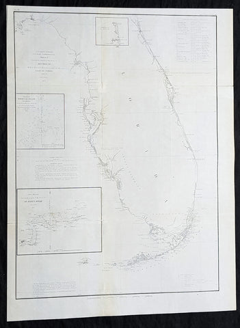
1855 A D Bache Large Rare Antique Map of Florida - US Coast Survey
- Title : US Coast Survey A D Bache Super. Sketch F Showing the Progress of the Survey in Section VI 1848-55...1855.
- Size: 25in x 18 1/2in (635mm x 470mm)
- Condition: (A+) Fine Condition
- Date : 1855
- Ref #: 93022
Description:
This large, rare, original antique lithograph early map of Florida and the progress of the surveys since 1848 by Alexander Dallas Bache (great-grandson of Benjamin Franklin) in 1855 - dated - was published by the official chart-maker of the United States, the office of The US Coast Survey.
The Office of the Coast Survey, founded in 1807 by President Thomas Jefferson and Secretary of Commerce Albert Gallatin, is the oldest scientific organization in the U.S. Federal Government. Jefferson created the Survey of the Coast, as it was then called, in response to a need for accurate navigational charts of the new nation\'s coasts and harbors.
General Definitions:
Paper thickness and quality: - Heavy and stable
Paper color : - off white
Age of map color: -
Colors used: -
General color appearance: -
Paper size: - 25in x 18 1/2in (635mm x 470mm)
Plate size: - 25in x 18 1/2in (635mm x 470mm)
Margins: - Min 1/2in (12mm)
Imperfections:
Margins: - None
Plate area: - Folds as issued
Verso: - Some folds re-enforced with archival tape
Background:
Florida was the first region of the continental United States to be visited and settled by Europeans. The earliest known European explorers came with the Spanish conquistador Juan Ponce de León. Ponce de León spotted and landed on the peninsula on April 2, 1513. He named the region Florida (land of flowers) The story that he was searching for the Fountain of Youth is mythical and only appeared long after his death.
In May 1539, Conquistador Hernando de Soto skirted the coast of Florida, searching for a deep harbor to land. He described seeing a thick wall of red mangroves spread mile after mile, some reaching as high as 70 feet (21 m), with intertwined and elevated roots making landing difficult. The Spanish introduced Christianity, cattle, horses, sheep, the Castilian language, and more to Florida. Spain established several settlements in Florida, with varying degrees of success. In 1559, Don Tristán de Luna y Arellano established a settlement at present-day Pensacola, making it the first attempted settlement in Florida, but it was mostly abandoned by 1561.
In 1565, the settlement of St. Augustine (San Agustín) was established under the leadership of admiral and governor Pedro Menéndez de Avilés, creating what would become one of the oldest, continuously-occupied European settlements in the continental U.S. and establishing the first generation of Floridanos and the Government of Florida. Spain maintained strategic control over the region by converting the local tribes to Christianity. The marriage between Luisa de Abrego, a free black domestic servant from Seville, and Miguel Rodríguez, a white Segovian, occurred in 1565 in St. Augustine. It is the first recorded Christian marriage in the continental United States.
Some Spanish married or had unions with Pensacola, Creek or African women, both slave and free, and their descendants created a mixed-race population of mestizos and mulattos. The Spanish encouraged slaves from the southern British colonies to come to Florida as a refuge, promising freedom in exchange for conversion to Catholicism. King Charles II of Spain issued a royal proclamation freeing all slaves who fled to Spanish Florida and accepted conversion and baptism. Most went to the area around St. Augustine, but escaped slaves also reached Pensacola. St. Augustine had mustered an all-black militia unit defending Spain as early as 1683.
The geographical area of Florida diminished with the establishment of English settlements to the north and French claims to the west. The English attacked St. Augustine, burning the city and its cathedral to the ground several times. Spain built the Castillo de San Marcos in 1672 and Fort Matanzas in 1742 to defend Floridas capital city from attacks, and to maintain its strategic position in the defense of the Captaincy General of Cuba and the Spanish West Indies.
Florida attracted numerous Africans and African Americans from adjacent British colonies who sought freedom from slavery. In 1738, Governor Manuel de Montiano established Fort Gracia Real de Santa Teresa de Mose near St. Augustine, a fortified town for escaped slaves to whom Montiano granted citizenship and freedom in return for their service in the Florida militia, and which became the first free black settlement legally sanctioned in North America.
In 1763, Spain traded Florida to the Kingdom of Great Britain for control of Havana, Cuba, which had been captured by the British during the Seven Years War. It was part of a large expansion of British territory following their victory in the Seven Years War. A large portion of the Floridano population left, taking along most of the remaining indigenous population to Cuba. The British soon constructed the Kings Road connecting St. Augustine to Georgia. The road crossed the St. Johns River at a narrow point called Wacca Pilatka, or the British name Cow Ford, ostensibly reflecting the fact that cattle were brought across the river there.
The British divided and consolidated the Florida provinces (Las Floridas) into East Florida and West Florida, a division the Spanish government kept after the brief British period. The British government gave land grants to officers and soldiers who had fought in the French and Indian War in order to encourage settlement. In order to induce settlers to move to Florida, reports of its natural wealth were published in England. A large number of British settlers who were described as being energetic and of good character moved to Florida, mostly coming from South Carolina, Georgia and England. There was also a group of settlers who came from the colony of Bermuda. This would be the first permanent English-speaking population in what is now Duval County, Baker County, St. Johns County and Nassau County. The British built good public roads and introduced the cultivation of sugar cane, indigo and fruits as well as the export of lumber.
The British governors were directed to call general assemblies as soon as possible in order to make laws for the Floridas, and in the meantime they were, with the advice of councils, to establish courts. This was the first introduction of the English-derived legal system which Florida still has today, including trial by jury, habeas corpus and county-based government. Neither East Florida nor West Florida sent any representatives to Philadelphia to draft the Declaration of Independence. Florida remained a Loyalist stronghold for the duration of the American Revolution.
Spain regained both East and West Florida after Britains defeat in the American Revolution and the subsequent Treaty of Versailles in 1783, and continued the provincial divisions until 1821.
Defense of Floridas northern border with the United States was minor during the second Spanish period. The region became a haven for escaped slaves and a base for Indian attacks against U.S. territories, and the U.S. pressed Spain for reform.
Americans of English descent and Americans of Scots-Irish descent began moving into northern Florida from the backwoods of Georgia and South Carolina. Though technically not allowed by the Spanish authorities and the Floridan government, they were never able to effectively police the border region and the backwoods settlers from the United States would continue to immigrate into Florida unchecked. These migrants, mixing with the already present British settlers who had remained in Florida since the British period, would be the progenitors of the population known as Florida Crackers.
These American settlers established a permanent foothold in the area and ignored Spanish authorities. The British settlers who had remained also resented Spanish rule, leading to a rebellion in 1810 and the establishment for ninety days of the so-called Free and Independent Republic of West Florida on September 23. After meetings beginning in June, rebels overcame the garrison at Baton Rouge (now in Louisiana), and unfurled the flag of the new republic: a single white star on a blue field. This flag would later become known as the Bonnie Blue Flag.
In 1810, parts of West Florida were annexed by proclamation of President James Madison, who claimed the region as part of the Louisiana Purchase. These parts were incorporated into the newly formed Territory of Orleans. The U.S. annexed the Mobile District of West Florida to the Mississippi Territory in 1812. Spain continued to dispute the area, though the United States gradually increased the area it occupied. In 1812, a group of settlers from Georgia, with de facto support from the U.S. federal government, attempted to overthrow the Floridan government in the province of East Florida. The settlers hoped to convince Floridans to join their cause and proclaim independence from Spain, but the settlers lost their tenuous support from the federal government and abandoned their cause by 1813.
Seminoles based in East Florida began raiding Georgia settlements, and offering havens for runaway slaves. The United States Army led increasingly frequent incursions into Spanish territory, including the 1817–1818 campaign against the Seminole Indians by Andrew Jackson that became known as the First Seminole War. The United States now effectively controlled East Florida. Control was necessary according to Secretary of State John Quincy Adams because Florida had become a derelict open to the occupancy of every enemy, civilized or savage, of the United States, and serving no other earthly purpose than as a post of annoyance to them.
Florida had become a burden to Spain, which could not afford to send settlers or garrisons. Madrid therefore decided to cede the territory to the United States through the Adams–Onís Treaty, which took effect in 1821. President James Monroe was authorized on March 3, 1821 to take possession of East Florida and West Florida for the United States and provide for initial governance. Andrew Jackson, on behalf of the U.S. federal government, served as a military commissioner with the powers of governor of the newly acquired territory for a brief period. On March 30, 1822, the U.S. Congress merged East Florida and part of West Florida into the Florida Territory.
By the early 1800s, Indian removal was a significant issue throughout the southeastern U.S. and also in Florida. In 1830, the U.S. Congress passed the Indian Removal Act and as settlement increased, pressure grew on the U.S. government to remove the Indians from Florida. Seminoles offered sanctuary to blacks, and these became known as the Black Seminoles, and clashes between whites and Indians grew with the influx of new settlers. In 1832, the Treaty of Paynes Landing promised to the Seminoles lands west of the Mississippi River if they agreed to leave Florida. Many Seminole left at this time.
Some Seminoles remained, and the U.S. Army arrived in Florida, leading to the Second Seminole War (1835–1842). Following the war, approximately 3,000 Seminole and 800 Black Seminole were removed to Indian Territory. A few hundred Seminole remained in Florida in the Everglades.
On March 3, 1845, only one day before the end of President John Tylers term in office, Florida became the 27th state to join the United States of America. The state was admitted as a slave state and ceased to be a sanctuary for runaway slaves. Initially its population grew slowly.
As European settlers continued to encroach on Seminole lands, and the United States intervened to move the remaining Seminoles to the West. The Third Seminole War (1855–58) resulted in the forced removal of most of the remaining Seminoles, although hundreds of Seminole Indians remained in the Everglades
American settlers began to establish cotton plantations in north Florida, which required numerous laborers, which they supplied by buying slaves in the domestic market. By 1860, Florida had only 140,424 people, of whom 44% were enslaved. There were fewer than 1,000 free African Americans before the American Civil War.
On January 10, 1861, nearly all delegates in the Florida Legislature approved an ordinance of secession, declaring Florida to be a sovereign and independent nation—an apparent reassertion to the preamble in Floridas Constitution of 1838, in which Florida agreed with Congress to be a Free and Independent State. Although not directly related to the issue of slavery, the ordinance declared Floridas secession from the Union, allowing it to become one of the founding members of the Confederate States, a looser union of states.
The Confederacy received little help from Florida; the 15,000 men it offered were generally sent elsewhere. Instead of men and manufactured goods, Florida did provide salt and, more importantly, beef to feed the Confederate armies. This was particularly important after 1864, when the Confederacy lost control of the Mississippi River, thereby losing access to Texas beef. The largest engagements in the state were the Battle of Olustee, on February 20, 1864, and the Battle of Natural Bridge, on March 6, 1865. Both were Confederate victories. The war ended in 1865.
Following the American Civil War, Floridas congressional representation was restored on June 25, 1868, albeit forcefully after Radical Reconstruction and the installation of unelected government officials under the final authority of federal military commanders. After the Reconstruction period ended in 1876, white Democrats regained power in the state legislature. In 1885, they created a new constitution, followed by statutes through 1889 that disfranchised most blacks and many poor whites.
Until the mid-20th century, Florida was the least populous state in the southern United States. In 1900, its population was only 528,542, of whom nearly 44% were African American, the same proportion as before the Civil War. The boll weevil devastated cotton crops.
Forty thousand blacks, roughly one-fifth of their 1900 population, left the state in the Great Migration. They left due to lynchings and racial violence, and for better opportunities. Disfranchisement for most African Americans in the state persisted until the Civil Rights Movement of the 1960s gained federal legislation in 1965 to enforce protection of their constitutional suffrage.
U.S. Coast Survey (Office of Coast Survey)
The Office of Coast Survey is the official chart-maker of the United States. Set up in 1807, it is one of the U.S. governments oldest scientific organizations. In 1878 it was given the name of Coast and Geodetic Survey (C&GS). In 1970 it became part of the National Oceanic and Atmospheric Administration (NOAA).
The agency was established in 1807 when President Thomas Jefferson signed the document entitled An act to provide for surveying the coasts of the United States. While the bills objective was specific—to produce nautical charts—it reflected larger issues of concern to the new nation: national boundaries, commerce, and defence.
The early years were difficult. Ferdinand Rudolph Hassler, who was eventually to become the agencys first superintendent, went to England to collect scientific instruments but was unable to return through the duration of the War of 1812. After his return, he worked on a survey of the New York Harbor in 1817, but Congress stepped in to suspend the work because of tensions between civilian and military control of the agency. After several years under the control of the U.S. Army, the Survey of the Coast was reestablished in 1832, and President Andrew Jackson appointed Hassler as superintendent.
The U.S. Coast Survey was a civilian agency but, from the beginning, members of the Navy and Army were detailed to service with the Survey, and Navy ships were also detailed to its use. In general, army officers worked on topographic surveys on the land and maps based on the surveys, while navy officers worked on hydrographic surveys in coastal waters.
Alexander Dallas Bache, great-grandson of Benjamin Franklin, was the second Coast Survey superintendent. Bache was a physicist, scientist, and surveyor who established the first magnetic observatory and served as the first president of the National Academy of Sciences. Under Bache, Coast Survey quickly applied its resources to the Union cause during the Civil War. In addition to setting up additional lithographic presses to produce the thousands of charts required by the Navy and other vessels, Bache made a critical decision to send Coast Survey parties to work with blockading squadrons and armies in the field, producing hundreds of maps and charts. Bache detailed these activities in his annual reports to Congress.
Coast Survey cartographer Edwin Hergesheimer created the map showing the density of the slave population in the Southern states.
Bache was also one of four members of the governments Blockade Strategy Board, planning strategy to essentially strangle the South, economically and militarily. On April 16, 1861, President Lincoln issued a proclamation declaring the blockade of ports from South Carolina to Texas. Baches Notes on the Coast provided valuable information for Union naval forces.
Maps were of paramount importance in wartime:
It is certain that accurate maps must form the basis of well-conducted military operations, and that the best time to procure them is not when an attack is impending, or when the army waits, but when there is no hindrance to, or pressure upon, the surveyors. That no coast can be effectively attacked, defended, or blockaded without accurate maps and charts, has been fully proved by the events of the last two years, if, indeed, such a proposition required practical proof.
— Alexander Dallas Bache, 1862 report.
Coast Survey attracted some of the best and brightest scientists and naturalists. It commissioned the naturalist Louis Agassiz to conduct the first scientific study of the Florida reef system. James McNeill Whistler, who went on to paint the iconic Whistlers Mother, was a Coast Survey engraver. The naturalist John Muir was a guide and artist on Survey of the 39th Parallel across the Great Basin of Nevada and Utah.
The agencys men and women (women professionals were hired as early as 1845) led scientific and engineering activities through the decades. In 1926, they started production of aeronautical charts. During the height of the Great Depression, Coast and Geodetic Survey organized surveying parties and field offices that employed over 10,000 people, including many out-of-work engineers.
In World War II, C&GS sent over 1,000 civilian members and more than half of its commissioned officers to serve as hydrographers, artillery surveyors, cartographers, army engineers, intelligence officers, and geophysicists in all theaters of the war. Civilians on the home front produced over 100 million maps and charts for the Allied Forces. Eleven members of the C&GS gave their lives during the war.
Alexander Dallas Bache 1806 – 1867 was an American physicist, scientist, and surveyor who erected coastal fortifications and conducted a detailed survey to map the mid-eastern United States coastline. Originally an army engineer, he later became Superintendent of the U.S. Coast Survey, and built it into the foremost scientific institution in the country before the Civil War.
Alexander Bache was born in Philadelphia, the son of Richard Bache, Jr., and Sophia Burrell Dallas Bache. He came from a prominent family as he was the nephew of Vice-President George M. Dallas and naval hero Alexander J. Dallas. He was the grandson of Secretary of the Treasury Alexander Dallas and was the great-grandson of Benjamin Franklin.
Bache was a professor of natural philosophy and chemistry at the University of Pennsylvania from 1828 to 1841 and again from 1842 to 1843. He spent 1836–1838 in Europe on behalf of the trustees of what became Girard College; he was named president of the college after his return. Abroad, he examined European education systems, and on his return he published a valuable report. From 1839 to 1842, he served as the first president of Central High School of Philadelphia, one of the oldest public high schools in the United States.
In 1843, on the death of Professor Ferdinand Rudolph Hassler, Bache was appointed superintendent of the United States Coast Survey. He convinced the United States Congress of the value of this work and, by means of the liberal aid it granted, he completed the mapping of the whole coast by a skillful division of labor and the erection of numerous observing stations. In addition, magnetic and meteorological data were collected. Bache served as head of the Coast Survey for 24 years (until his death).
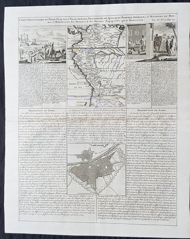
1719 Chatelain Antique Map, Views & Plans of Peru & Lima South America
- Title : Carte Particuliere du Perou, Plan de la Ville de Lima, Description de Quelques Plantes, Animaux, &....
- Size: 20in x 17 1/2in (510mm x 440mm)
- Condition: (A+) Fine Condition
- Date : 1719
- Ref #: 50632
Description:
This large original copper-plate engraved antique map & views of Peru & NW South America with a city plan of Lima was published by Henri Abraham Chatelain in 1719, in his famous Atlas Historique.
These are truly some of the best early engravings of this region done at the time that were copied by the likes of Prevost, Harrison & others in the 18th century, but not with the same eye for detail.
General Definitions:
Paper thickness and quality: - Heavy and stable
Paper color : - off white
Age of map color: -
Colors used: -
General color appearance: -
Paper size: - 20in x 17 1/2in (510mm x 440mm)
Plate size: - 17 1/2in x 15in (440mm x 380mm)
Margins: - Min 1in (25mm)
Imperfections:
Margins: - None
Plate area: - None
Verso: - None
Background:
Atahualpa (also Atahuallpa), the last Sapa Inca became emperor when he defeated and executed his older half-brother Huáscar in a civil war sparked by the death of their father, Inca Huayna Capac. In December 1532, a party of conquistadors led by Francisco Pizarro defeated and captured the Inca Emperor Atahualpa in the Battle of Cajamarca. The Spanish conquest of the Inca Empire was one of the most important campaigns in the Spanish colonization of the Americas. After years of preliminary exploration and military conflicts, it was the first step in a long campaign that took decades of fighting but ended in Spanish victory and colonization of the region known as the Viceroyalty of Peru with its capital at Lima, which became known as The City of Kings. The conquest of the Inca Empire led to spin-off campaigns throughout the viceroyalty as well as expeditions towards the Amazon Basin as in the case of Spanish efforts to quell Amerindian resistance. The last Inca resistance was suppressed when the Spaniards annihilated the Neo-Inca State in Vilcabamba in 1572.
The indigenous population dramatically collapsed due to exploitation, socioeconomic change and epidemic diseases introduced by the Spanish. Viceroy Francisco de Toledo reorganized the country in the 1570s with gold and silver mining as its main economic activity and Amerindian forced labor as its primary workforce. With the discovery of the great silver and gold lodes at Potosí (present-day Bolivia) and Huancavelica, the viceroyalty flourished as an important provider of mineral resources. Peruvian bullion provided revenue for the Spanish Crown and fueled a complex trade network that extended as far as Europe and the Philippines. Because of lack of available work force, African slaves were added to the labor population. The expansion of a colonial administrative apparatus and bureaucracy paralleled the economic reorganization. With the conquest started the spread of Christianity in South America; most people were forcefully converted to Catholicism, taking only a generation to convert the population. They built churches in every city and replaced some of the Inca temples with churches, such as the Coricancha in the city of Cusco. The church employed the Inquisition, making use of torture to ensure that newly converted Catholics did not stray to other religions or beliefs. Peruvian Catholicism follows the syncretism found in many Latin American countries, in which religious native rituals have been integrated with Christian celebrations. In this endeavor, the church came to play an important role in the acculturation of the natives, drawing them into the cultural orbit of the Spanish settlers.
By the 18th century, declining silver production and economic diversification greatly diminished royal income. In response, the Crown enacted the Bourbon Reforms, a series of edicts that increased taxes and partitioned the Viceroyalty. The new laws provoked Túpac Amaru IIs rebellion and other revolts, all of which were suppressed. As a result of these and other changes, the Spaniards and their creole successors came to monopolize control over the land, seizing many of the best lands abandoned by the massive native depopulation. However, the Spanish did not resist the Portuguese expansion of Brazil across the meridian. The Treaty of Tordesillas was rendered meaningless between 1580 and 1640 while Spain controlled Portugal. The need to ease communication and trade with Spain led to the split of the viceroyalty and the creation of new viceroyalties of New Granada and Rio de la Plata at the expense of the territories that formed the viceroyalty of Peru; this reduced the power, prominence and importance of Lima as the viceroyal capital and shifted the lucrative Andean trade to Buenos Aires and Bogotá, while the fall of the mining and textile production accelerated the progressive decay of the Viceroyalty of Peru.
Eventually, the viceroyalty would dissolve, as with much of the Spanish empire, when challenged by national independence movements at the beginning of the nineteenth century. These movements led to the formation of the majority of modern-day countries of South America in the territories that at one point or another had constituted the Viceroyalty of Peru. The conquest and colony brought a mix of cultures and ethnicities that did not exist before the Spanish conquered the Peruvian territory. Even though many of the Inca traditions were lost or diluted, new customs, traditions and knowledge were added, creating a rich mixed Peruvian culture. Two of the most important indigenous rebellions against the Spanish were that of Juan Santos Atahualpa in 1742, and Rebellion of Túpac Amaru II in 1780 around the highlands near Cuzco.
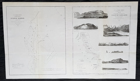
1860 US Coast Survey & A D Bache Rare Antique Geological Map of the Coast of Labrador NFL Canada
- Title : US Coast Survey A D Bache Superintendant Sketch Showing the Geology of the Coast of Labrador....1860
- Size: 28 1/2in x 17in (725mm x 430mm)
- Condition: (A+) Fine Condition
- Date : 1860
- Ref #: 93039
Description:
This large, rare, original antique lithograph early map of the geology of the Western coastline of the Labrador Coast, Canada - from the St Lawrence River mouth north to Cape Chidley - with a map of Eclipse Bay, by Alexander Dallas Bache (great-grandson of Benjamin Franklin) in 1860 - dated - was published by the official chart-maker of the United States, the office of The US Coast Survey.
The Office of the Coast Survey, founded in 1807 by President Thomas Jefferson and Secretary of Commerce Albert Gallatin, is the oldest scientific organization in the U.S. Federal Government. Jefferson created the Survey of the Coast, as it was then called, in response to a need for accurate navigational charts of the new nation\'s coasts and harbors.
General Definitions:
Paper thickness and quality: - Heavy and stable
Paper color : - off white
Age of map color: -
Colors used: -
General color appearance: -
Paper size: - 28 1/2in x 17in (725mm x 430mm)
Plate size: - 28 1/2in x 17in (725mm x 430mm)
Margins: - Min 1/2in (12mm)
Imperfections:
Margins: - None
Plate area: - None
Verso: - None
Background:
This is a beautiful 1860 map or chart showing the geology along the coast of Labrador in the Canadian province of Newfoundland and Labrador issued by the U.S. Coast Survey. The chart shows the distribution of the different types of rocks or geological formations of the region, extending from the Gulf of St. Lawrence northward to Cape Chidley and Ungava Bay. Perhaps the most interesting feature of this chart is the series of coastal views including View of Mt. Bache, Aulezavik Island, View of the Crater shaped Mt. E Side of Aulezavik Island, View of high peaks between Aulezavik Sound and Ungava Bay, View of Coast of Labrador, Mugford Island, Entrance to Port Manvers, and View of Battle Island.
The map was drawn from original sketches of Oscar Montgomery Lieber, who accompanied the American astronomical expedition to Labrador as geologist. This map was created under the direction of A. D. Bache, Superintendent of the Survey of the Coast of the United States and one of the most influential American cartographers of the 19th century. Issued for the 1860 Superintendents Report.
U.S. Coast Survey (Office of Coast Survey)
The Office of Coast Survey is the official chart-maker of the United States. Set up in 1807, it is one of the U.S. governments oldest scientific organizations. In 1878 it was given the name of Coast and Geodetic Survey (C&GS). In 1970 it became part of the National Oceanic and Atmospheric Administration (NOAA).
The agency was established in 1807 when President Thomas Jefferson signed the document entitled An act to provide for surveying the coasts of the United States. While the bills objective was specific—to produce nautical charts—it reflected larger issues of concern to the new nation: national boundaries, commerce, and defence.
The early years were difficult. Ferdinand Rudolph Hassler, who was eventually to become the agencys first superintendent, went to England to collect scientific instruments but was unable to return through the duration of the War of 1812. After his return, he worked on a survey of the New York Harbor in 1817, but Congress stepped in to suspend the work because of tensions between civilian and military control of the agency. After several years under the control of the U.S. Army, the Survey of the Coast was reestablished in 1832, and President Andrew Jackson appointed Hassler as superintendent.
The U.S. Coast Survey was a civilian agency but, from the beginning, members of the Navy and Army were detailed to service with the Survey, and Navy ships were also detailed to its use. In general, army officers worked on topographic surveys on the land and maps based on the surveys, while navy officers worked on hydrographic surveys in coastal waters.
Alexander Dallas Bache, great-grandson of Benjamin Franklin, was the second Coast Survey superintendent. Bache was a physicist, scientist, and surveyor who established the first magnetic observatory and served as the first president of the National Academy of Sciences. Under Bache, Coast Survey quickly applied its resources to the Union cause during the Civil War. In addition to setting up additional lithographic presses to produce the thousands of charts required by the Navy and other vessels, Bache made a critical decision to send Coast Survey parties to work with blockading squadrons and armies in the field, producing hundreds of maps and charts. Bache detailed these activities in his annual reports to Congress.
Coast Survey cartographer Edwin Hergesheimer created the map showing the density of the slave population in the Southern states.
Bache was also one of four members of the governments Blockade Strategy Board, planning strategy to essentially strangle the South, economically and militarily. On April 16, 1861, President Lincoln issued a proclamation declaring the blockade of ports from South Carolina to Texas. Baches Notes on the Coast provided valuable information for Union naval forces.
Maps were of paramount importance in wartime:
It is certain that accurate maps must form the basis of well-conducted military operations, and that the best time to procure them is not when an attack is impending, or when the army waits, but when there is no hindrance to, or pressure upon, the surveyors. That no coast can be effectively attacked, defended, or blockaded without accurate maps and charts, has been fully proved by the events of the last two years, if, indeed, such a proposition required practical proof.
— Alexander Dallas Bache, 1862 report.
Coast Survey attracted some of the best and brightest scientists and naturalists. It commissioned the naturalist Louis Agassiz to conduct the first scientific study of the Florida reef system. James McNeill Whistler, who went on to paint the iconic Whistlers Mother, was a Coast Survey engraver. The naturalist John Muir was a guide and artist on Survey of the 39th Parallel across the Great Basin of Nevada and Utah.
The agencys men and women (women professionals were hired as early as 1845) led scientific and engineering activities through the decades. In 1926, they started production of aeronautical charts. During the height of the Great Depression, Coast and Geodetic Survey organized surveying parties and field offices that employed over 10,000 people, including many out-of-work engineers.
In World War II, C&GS sent over 1,000 civilian members and more than half of its commissioned officers to serve as hydrographers, artillery surveyors, cartographers, army engineers, intelligence officers, and geophysicists in all theaters of the war. Civilians on the home front produced over 100 million maps and charts for the Allied Forces. Eleven members of the C&GS gave their lives during the war.
Alexander Dallas Bache 1806 – 1867 was an American physicist, scientist, and surveyor who erected coastal fortifications and conducted a detailed survey to map the mid-eastern United States coastline. Originally an army engineer, he later became Superintendent of the U.S. Coast Survey, and built it into the foremost scientific institution in the country before the Civil War.
Alexander Bache was born in Philadelphia, the son of Richard Bache, Jr., and Sophia Burrell Dallas Bache. He came from a prominent family as he was the nephew of Vice-President George M. Dallas and naval hero Alexander J. Dallas. He was the grandson of Secretary of the Treasury Alexander Dallas and was the great-grandson of Benjamin Franklin.
Bache was a professor of natural philosophy and chemistry at the University of Pennsylvania from 1828 to 1841 and again from 1842 to 1843. He spent 1836–1838 in Europe on behalf of the trustees of what became Girard College; he was named president of the college after his return. Abroad, he examined European education systems, and on his return he published a valuable report. From 1839 to 1842, he served as the first president of Central High School of Philadelphia, one of the oldest public high schools in the United States.
In 1843, on the death of Professor Ferdinand Rudolph Hassler, Bache was appointed superintendent of the United States Coast Survey. He convinced the United States Congress of the value of this work and, by means of the liberal aid it granted, he completed the mapping of the whole coast by a skillful division of labor and the erection of numerous observing stations. In addition, magnetic and meteorological data were collected. Bache served as head of the Coast Survey for 24 years (until his death).