America (67)
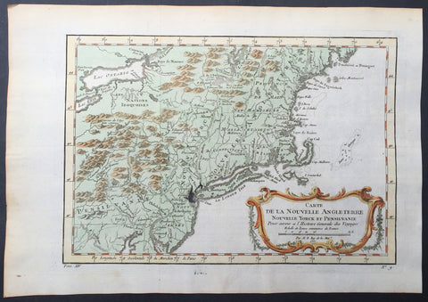
1757 Bellin Antique Map of New England, New York, New Jersey, Pennsylvania
- Title : Carte De La Nouvelle Angleterre...Par M B. 1757
- Ref #: 61097
- Size: 14 1/2in x 10in (370mm x 255mm)
- Date : 1757
- Condition: (A+) Fine Condition
Description:
This beautifully hand coloured original antique map of New England & the NE corridor of the US from Pennsylvania to Maine was engraved in 1757 - the date is engraved in the title - and was published in the 1757 French edition of Antoine-François Prevosts 20 volume L`Histoire Generale des Voyages published by Pierre de Hondt in the Hague between 1747 & 1785.
Antoine François Prévost d'Exiles 1697 - 1763, usually known simply as the Abbé Prévost, was a French author and novelist. (Ref: Tooley; M&B)
General Description:
Paper thickness and quality: - Heavy and stable
Paper color: - white
Age of map color: - Early
Colors used: - Green, yellow, red
General color appearance: - Authentic
Paper size: - 14 1/2in x 10in (370mm x 255mm)
Plate size: - 12 1/2in x 9in (320mm x 225mm)
Margins: - min. 1in (25mm)
Imperfections:
Margins: - None
Plate area: - Folds as issued, ink bleed from original plate
Verso: - None
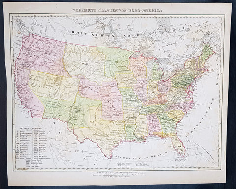
1854 Handtke & Flemming Large Antique Map of The United States of America - 32 States
- Title : Vereinigte Staaten Von Nord-America
- Ref #: 41103
- Size: 17in x 14in (430mm x 355mm)
- Date : 1854
- Condition: (A+) Fine Condition
Description:
This beautifully hand coloured original steel-plate engraved antique map of the United States in the mid 19th century, by Friedrich Handtke in 1854, was published in the Complete hand atlas of the recent description of the earth over all parts of the earth, Carl Flemming, Glougau.
At the bottom left of the map is an index of all states and territories. 32 States are listed with California the last, accepted into the union in 1850 and 5 territories are listed, Oregon, Missouri, Minnesota, Indian & Utah.
General Definitions:
Paper thickness and quality: - Heavy and stable
Paper color : - off white
Age of map color: - Original
Colors used: - Yellow, green, blue, pink
General color appearance: - Authentic
Paper size: - 17in x 14in (430mm x 355mm)
Plate size: - 17in x 14in (430mm x 355mm)
Margins: - Min 1/2in (12mm)
Imperfections:
Margins: - Light age toning
Plate area: - Light age toning
Verso: - Light age toning
Background:
After the conclusion of the Civil War three things happened that opened up the western states, migration, gold and the building of the railway from the Atlantic to the Pacific. This map shows a country prior to the civil war still defining itself with much of the country west of the Mississippi regions yet to be opened and defined.
Mexico became independent of Spain in 1821, and took over Spains northern possessions stretching from Texas to California. Caravans began delivering goods to Mexicos Santa Fe along the Santa Fe Trail, over the 870-mile journey which took 48 days from Kansas City, Missouri (then known as Westport). Santa Fe was also the trailhead for the El Camino Real (the Kings Highway), a trade route which carried American manufactured goods southward deep into Mexico and returned silver, furs, and mules northward (not to be confused with another Camino Real which connected the missions in California). A branch also ran eastward near the Gulf (also called the Old San Antonio Road). Santa Fe connected to California via the Old Spanish Trail.
The Spanish and Mexican governments attracted American settlers to Texas with generous terms. Stephen F. Austin became an empresario, receiving contracts from the Mexican officials to bring in immigrants. In doing so, he also became the de facto political and military commander of the area. Tensions rose, however, after an abortive attempt to establish the independent nation of Fredonia in 1826. William Travis, leading the war party, advocated for independence from Mexico, while the peace party led by Austin attempted to get more autonomy within the current relationship. When Mexican president Santa Anna shifted alliances and joined the conservative Centralist party, he declared himself dictator and ordered soldiers into Texas to curtail new immigration and unrest. However, immigration continued and 30,000 Anglos with 3,000 slaves were settled in Texas by 1835. In 1836, the Texas Revolution erupted. Following losses at the Alamo and Goliad, the Texians won the decisive Battle of San Jacinto to secure independence. At San Jacinto, Sam Houston, commander-in-chief of the Texian Army and future President of the Republic of Texas famously shouted Remember the Alamo! Remember Goliad. The U.S. Congress declined to annex Texas, stalemated by contentious arguments over slavery and regional power. Thus, the Republic of Texas remained an independent power for nearly a decade before it was annexed as the 28th state in 1845. The government of Mexico, however, viewed Texas as a runaway province and asserted its ownership.
Mexico refused to recognize the independence of Texas in 1836, but the U.S. and European powers did so. Mexico threatened war if Texas joined the U.S., which it did in 1845. American negotiators were turned away by a Mexican government in turmoil. When the Mexican army killed 16 American soldiers in disputed territory war was at hand. Whigs, such as Congressman Abraham Lincoln denounced the war, but it was quite popular outside New England.
The Mexican strategy was defensive; the American strategy was a three pronged offensive, using large numbers of volunteer soldiers. Overland forces seized New Mexico with little resistance and headed to California, which quickly fell to the American land and naval forces. From the main American base at New Orleans, General Zachary Taylor led forces into northern Mexico, winning a series of battles that ensued. The U.S. Navy transported General Winfield Scott to Veracruz. He then marched his 12,000-man force west to Mexico City, winning the final battle at Chapultepec. Talk of acquiring all of Mexico fell away when the army discovered the Mexican political and cultural values were so alien to Americas. As the Cincinnati Herald asked, what would the U.S. do with eight million Mexicans with their idol worship, heathen superstition, and degraded mongrel races?
The Treaty of Guadalupe Hidalgo of 1848 ceded the territories of California and New Mexico to the United States for $18.5 million (which included the assumption of claims against Mexico by settlers). The Gadsden Purchase in 1853 added southern Arizona, which was needed for a railroad route to California. In all Mexico ceded half a million square miles (1.3 million km2) and included the states-to-be of California, Utah, Arizona, Nevada, New Mexico, and parts of Colorado and Wyoming, in addition to Texas. Managing the new territories and dealing with the slavery issue caused intense controversy, particularly over the Wilmot Proviso, which would have outlawed slavery in the new territories. Congress never passed it, but rather temporarily resolved the issue of slavery in the West with the Compromise of 1850. California entered the Union in 1850 as a free state; the other areas remained territories for many years.
The new state grew rapidly as migrants poured into the fertile cotton lands of east Texas. German immigrants started to arrive in the early 1840s because of negative economic, social and political pressures in Germany. With their investments in cotton lands and slaves, planters established cotton plantations in the eastern districts. The central area of the state was developed more by subsistence farmers who seldom owned slaves.
Texas in its Wild West days attracted men who could shoot straight and possessed the zest for adventure, for masculine renown, patriotic service, martial glory and meaningful deaths.
In 1846 about 10,000 Californios (Hispanics) lived in California, primarily on cattle ranches in what is now the Los Angeles area. A few hundred foreigners were scattered in the northern districts, including some Americans. With the outbreak of war with Mexico in 1846 the U.S. sent in Frémont and a U.S. Army unit, as well as naval forces, and quickly took control. As the war was ending, gold was discovered in the north, and the word soon spread worldwide.
Thousands of Forty-Niners reached California, by sailing around South America (or taking a short-cut through disease-ridden Panama), or walked the California trail. The population soared to over 200,000 in 1852, mostly in the gold districts that stretched into the mountains east of San Francisco.
Housing in San Francisco was at a premium, and abandoned ships whose crews had headed for the mines were often converted to temporary lodging. In the gold fields themselves living conditions were primitive, though the mild climate proved attractive. Supplies were expensive and food poor, typical diets consisting mostly of pork, beans, and whiskey. These highly male, transient communities with no established institutions were prone to high levels of violence, drunkenness, profanity, and greed-driven behavior. Without courts or law officers in the mining communities to enforce claims and justice, miners developed their own ad hoc legal system, based on the mining codes used in other mining communities abroad. Each camp had its own rules and often handed out justice by popular vote, sometimes acting fairly and at times exercising vigilantism—with Indians, Mexicans, and Chinese generally receiving the harshest sentences.
The gold rush radically changed the California economy and brought in an array of professionals, including precious metal specialists, merchants, doctors, and attorneys, who added to the population of miners, saloon keepers, gamblers, and prostitutes. A San Francisco newspaper stated, The whole country... resounds to the sordid cry of gold! Gold! Gold! while the field is left half planted, the house half built, and everything neglected but the manufacture of shovels and pick axes. Over 250,000 miners found a total of more than $200 million in gold in the five years of the California Gold Rush. As thousands arrived, however, fewer and fewer miners struck their fortune, and most ended exhausted and broke.
Violent bandits often preyed upon the miners, such as the case of Jonathan R. Davis killing of eleven bandits single-handedly. Camps spread out north and south of the American River and eastward into the Sierras. In a few years, nearly all of the independent miners were displaced as mines were purchased and run by mining companies, who then hired low-paid salaried miners. As gold became harder to find and more difficult to extract, individual prospectors gave way to paid work gangs, specialized skills, and mining machinery. Bigger mines, however, caused greater environmental damage. In the mountains, shaft mining predominated, producing large amounts of waste. Beginning in 1852, at the end of the 49 gold rush, through 1883, hydraulic mining was used. Despite huge profits being made, it fell into the hands of a few capitalists, displaced numerous miners, vast amounts of waste entered river systems, and did heavy ecological damage to the environment. Hydraulic mining ended when public outcry over the destruction of farmlands led to the outlawing of this practice.
The mountainous areas of the triangle from New Mexico to California to South Dakota contained hundreds of hard rock mining sites, where prospectors discovered gold, silver, copper and other minerals (as well as some soft-rock coal). Temporary mining camps sprang up overnight; most became ghost towns when the ores were depleted. Prospectors spread out and hunted for gold and silver along the Rockies and in the southwest. Soon gold was discovered in Colorado, Utah, Arizona, New Mexico, Idaho, Montana, and South Dakota (by 1864).
The discovery of the Comstock Lode, containing vast amounts of silver, resulted in the Nevada boomtowns of Virginia City, Carson City, and Silver City. The wealth from silver, more than from gold, fueled the maturation of San Francisco in the 1860s and helped the rise of some of its wealthiest families, such as that of George Hearst.
To get to the rich new lands of the West Coast, there were two options: some sailed around the southern tip of South America during a six-month voyage, but 400,000 others walked there on an overland route of more than 2,000 miles (3,000 km); their wagon trains usually left from Missouri. They moved in large groups under an experienced wagonmaster, bringing their clothing, farm supplies, weapons, and animals. These wagon trains followed major rivers, crossed prairies and mountains, and typically ended in Oregon and California. Pioneers generally attempted to complete the journey during a single warm season, usually over the course of six months. By 1836, when the first migrant wagon train was organized in Independence, Missouri, a wagon trail had been cleared to Fort Hall, Idaho. Trails were cleared further and further west, eventually reaching all the way to the Willamette Valley in Oregon. This network of wagon trails leading to the Pacific Northwest was later called the Oregon Trail. The eastern half of the route was also used by travelers on the California Trail (from 1843), Mormon Trail (from 1847), and Bozeman Trail (from 1863) before they turned off to their separate destinations.
In the Wagon Train of 1843, some 700 to 1,000 emigrants headed for Oregon; missionary Marcus Whitman led the wagons on the last leg. In 1846, the Barlow Road was completed around Mount Hood, providing a rough but passable wagon trail from the Missouri River to the Willamette Valley: about 2,000 miles. Though the main direction of travel on the early wagon trails was westward, people also used the Oregon Trail to travel eastward. Some did so because they were discouraged and defeated. Some returned with bags of gold and silver. Most were returning to pick up their families and move them all back west. These gobacks were a major source of information and excitement about the wonders and promises—and dangers and disappointments—of the far West.
Not all emigrants made it to their destination. The dangers of the overland route were numerous: snakebites, wagon accidents, violence from other travelers, suicide, malnutrition, stampedes, Indian attacks, a variety of diseases (dysentery, typhoid, and cholera were among the most common), exposure, avalanches, etc. One particularly well-known example of the treacherous nature of the journey is the story of the ill-fated Donner Party, which became trapped in the Sierra Nevada mountains during the winter of 1846–1847 in which nearly half of the 90 people traveling with the group died from starvation and exposure, and some resorted to cannibalism to survive. Another story of cannibalism featured Alfred Packer and his trek to Colorado in 1874. There were also frequent attacks from bandits and highwaymen, such as the infamous Harpe brothers who patrolled the frontier routes and targeted migrant groups.
In Missouri and Illinois, animosity between the Mormon settlers and locals grew, which would mirror those in other states such as Utah years later. Violence finally erupted on October 24, 1838 when militias from both sides clashed and a mass killing of Mormons in Livingston County occurred 6 days later. An executive order was filed during these conflicts, and the Mormons were forced to scatter. Brigham Young, seeking to leave American jurisdiction to escape religious persecution in Illinois and Missouri, led the Mormons to the valley of the Great Salt Lake, owned at the time by Mexico but not controlled by them. A hundred rural Mormon settlements sprang up in what Young called Deseret, which he ruled as a theocracy. It later became Utah Territory. Youngs Salt Lake City settlement served as the hub of their network, which reached into neighboring territories as well. The communalism and advanced farming practices of the Mormons enabled them to succeed. They sold goods to wagon trains passing through and came to terms with local Indian tribes because Young decided it was cheaper to feed the Indians than fight them. Education became a high priority to protect the beleaguered group, reduce heresy and maintain group solidarity.
The great threat to the Mormons in Utah was the U.S. government, which took ownership of Utah in 1848, and pushed by the Protestant churches, rejected theocracy and polygamy. The Republican Party swore to destroy polygamy, which it saw as an affront to religious, cultural and moral values of a modern civilization. Confrontations verged on open warfare in the late 1850s as President Buchanan sent in troops. Although there were no military battles fought, and negotiations led to a stand down, violence still escalated and there were a number of casualties. After the Civil War the federal government systematically took control of Utah away from the Mormons, and drove the churchs leadership underground. Meanwhile, aggressive missionary work in the U.S. and Europe brought a flood of Mormon converts to Utah. Finally in 1890 the Church leadership announced polygamy was no longer a central tenet, and a compromise was reached, with Utah becoming a state and the Mormons dividing into Republicans and Democrats.
Constitutionally, Congress could not deal with slavery in the states but it did have jurisdiction in the western territories. California unanimously rejected slavery in 1850 and became a free state. New Mexico allowed slavery, but it was rarely seen there. Kansas was off limits to slavery by the Compromise of 1820. Free Soil elements feared that if slavery were allowed rich planters would buy up the best lands and work them with gangs of slaves, leaving little opportunity for free white men to own farms. Few Southern planters were actually interested in Kansas, but the idea that slavery was illegal there implied they had a second-class status that was intolerable to their sense of honor, and seemed to violate the principle of states rights. With the passage of the extremely controversial Kansas–Nebraska Act in 1854, Congress left the decision up to the voters on the ground in Kansas. Across the North a new major party was formed to fight slavery: the Republican Party, with numerous westerners in leadership positions, most notably Abraham Lincoln of Illinois. To influence the territorial decision, anti-slavery elements (also called Jayhawkers or Free-soilers) financed the migration of politically determined settlers. But pro-slavery advocates fought back with pro-slavery settlers from Missouri. Violence on both sides was the result; in all 56 men were killed by the time the violence abated in 1859. By 1860 the pro-slavery forces were in control—but Kansas had only two slaves. The antislavery forces took over by 1861, as Kansas became a free state. The episode demonstrated that a democratic compromise between North and South over slavery was impossible and served to hasten the Civil War.
Handtke, Friedrich 1815 - 1879
Handtke was a 19th century German cartographer who trained as a surveyor. After serving a year in the Prussian army, in 1838 he began work as head of the cartographic department at the publishing bookstore Carl Flemming in Glogau, Silesia. Of the 260 maps published by Flemming over 165 were drawn by Handtke.
Handtkes most important work was the Hand Atlas of the Prussian State of 1846 with 36 maps. He also published important maps of the Prussian state & a Map of Neuchâtel and Valendis & the nine provinces; East Prussia , West Prussia , Pomerania , Poznan , Silesia , Brandenburg , Saxony , Westphalia and the Rhine Province and the 25 administrative districts. One of Handtkes students was the German cartographer Paul Thumann .
Atlases published:
- Complete hand atlas of the recent description of the earth over all parts of the earth , Flemming, Glogau 1849.
- Hand Atlas of the Prussian State Flemming, Glogau 1846
- Royal Prussian Card. Province of Saxony, the duchy of Anhalt, the ducal. Saxon countries Weimar, Altenburg u. Gotha and the principals Schwarzburg and Reuss , Flemming, Glogau 1870/71
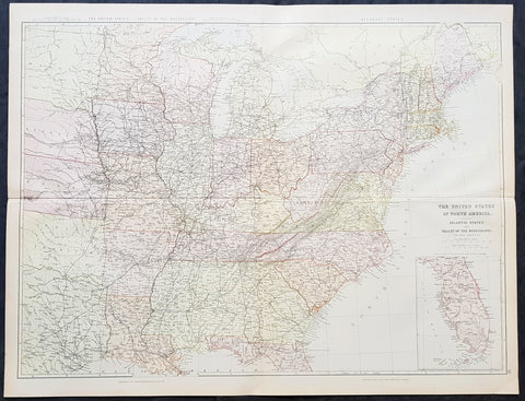
1860 Blackie & Son Large Antique Map of The Eastern United States, inset Florida
- Title : The United States of North America Atlantic States and Valley of the Mississippi
- Size: 28in x 22in (715mm x 560mm)
- Condition: (A+) Fine Condition
- Date : 1860
- Ref #: 80569
Description:
This 2 sheet joined original antique lithograph map of the eastern United States of America - west to the Mississippi Valley & Indian Territory - with and an inset map of Florida - was engraved by Edward Weller and published by Blackie & Son of Glasgow in the 1860 edition of Geographical Atlas. (Ref: Tooley; M&B)
General Definitions:
Paper thickness and quality: - Heavy and stable
Paper color : - off white
Age of map color: - Original
Colors used: - Yellow, green, blue, pink
General color appearance: - Authentic
Paper size: - 28in x 22in (715mm x 560mm)
Plate size: - 28in x 22in (715mm x 560mm)
Margins: - Min 1/2in (12mm)
Imperfections:
Margins: - None
Plate area: - None
Verso: - None
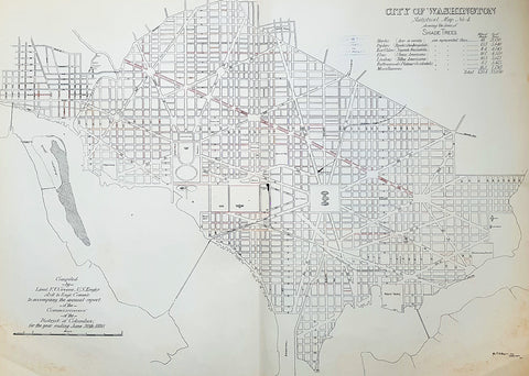
1880 F V Greene Large Antique Map Lines of Planted Trees in Washington DC
- Title : City of Washington Statistical Map No 4 showing the lines of Shade Trees.....Compiled by Lieut. F V Greene, US Engrs. Asst to the Engr. Commr. to accompany the annual report of the Commissioners of the District of Columbia for the year ending June 30th 1880
- Size: 30in x 23in (767mm x 585mm)
- Condition: (A) Very Good Condition
- Date : 1880
- Ref #: 16266
Description:
This large original lithograph map, a city plan of Washington DC, showing the lines of Trees planted very early in the cities growth, by Lieutenant Francis Vinton Greene, was published in June 1880, dated.
General Definitions:
Paper thickness and quality: - Heavy and stable
Paper color : - off white
Age of map color: - Original
Colors used: - Blue, pink, red, green, yellow
General color appearance: - Authentic
Paper size: - 30in x 23in (767mm x 585mm)
Plate size: - 30in x 23in (767mm x 585mm)
Margins: - Min 1/2in (12mm)
Imperfections:
Margins: - Light soiling L&R bottom corners
Plate area: - None
Verso: - Bottom L&R bottom corner backing canvas loose
Background:
The history of Washington, D.C. is tied to its role as the capital of the United States. Originally inhabited by an Algonquian-speaking people known as the Nacotchtank. the site of the District of Columbia along the Potomac River was first selected by President George Washington. The city came under attack during the War of 1812 in an episode known as the Burning of Washington. Upon the government\'s return to the capital, it had to manage reconstruction of numerous public buildings, including the White House and the United States Capitol.
By 1870, the District\'s population had grown 75% from the previous census to nearly 132,000 residents. Despite the citys growth, Washington still had dirt roads and lacked basic sanitation. The situation was so bad that some members of Congress suggested moving the capital further west, but President Ulysses S. Grant refused to consider such a proposal.
In response to the poor conditions in the capital, Congress passed the Organic Act of 1871, which revoked the individual charters of the cities of Washington and Georgetown, and created a new territorial government for the whole District of Columbia. The act provided for a governor appointed by the President, a legislative assembly with an upper-house composed of eleven appointed council members and a 22-member house of delegates elected by residents of the District, as well as an appointed Board of Public Works charged with modernizing the city.
President Grant appointed Alexander Robey Shepherd, an influential member of the Board of Public Works, to the post of governor in 1873. Shepherd authorized large-scale municipal projects, which greatly modernized Washington. However, the governor spent three times the money that had been budgeted for capital improvements and ultimately bankrupted the city. In 1874, Congress abolished the Districts territorial government and replaced it with a three-member Board of Commissioners appointed by the President, of which one was a representative from the United States Army Corps of Engineers. The three Commissioners would then elect one of themselves to be president of the commission.
An additional act of Congress in 1878 made the three-member Board of Commissioners the permanent government of the District of Columbia. The act also had the effect of eliminating any remaining local institutions such as the boards on schools, health, and police. The Commissioners would maintain this form of direct rule for nearly a century.
Greene, Francis Vinton 1850–1921
Greene was a United States Army officer who fought in the Spanish–American War. He came from the Greene family of Rhode Island, noted for its long line of participants in American military history.
Greene was born in Providence, Rhode Island on June 27, 1850. He attended the United States Military Academy at West Point and graduated in 1870. He first served in the U.S. artillery and then transferred to the Corps of Engineers in 1872. He next served as an attaché from the War Department to the U.S. legation in St. Petersburg, Russia. While there he served in the Russian army during its war with Turkey. He was promoted to first lieutenant in 1874 and captiain in 1883. He returned to the U.S. and was a civil engineer to the city of Washington, D.C. and was a professor of artillery at West Point before resigning from the Army on December 31, 1886.
When the Spanish–American War broke out he raised the 7th New York Volunteer Infantry and was commissoned as it colonel on May 2, 1898. He was quickly promoted to brigadier general of Volunteers on May 27, 1898. He commanded the second Philippine Expeditionary Force which became the 2nd Brigade, 2nd Division, VIII Corps. Greene took a prominent part in the Battle of Manila in 1898. He assisted in the surrender negotiations for Manila. In August 1898 he was promoted major general of Volunteers and resigned on February 28, 1899.
After the war, he pursued a variety of occupations. He was a delegate to the Republican National Convention in 1900. He served as the New York City Police Commissioner from 1903 to 1904. He was president of the Niagara-Lockport and Ontario Power Company, along with other business ventures with Buffalo businessman John J. Albright. He died on May 13, 1921 in New York City.
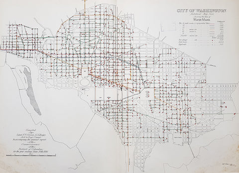
1880 F V Greene Large Antique Map Location of the Water Mains in Washington DC
- Title : City of Washington Statistical Map No 6 showing the lines of Water Mains...Compiled by Lieut. F V Greene, US Engrs. Asst to the Engr. Commr. to accompany the annual report of the Commissioners of the District of Columbia for the year ending June 30th 1880
- Size: 30in x 23in (767mm x 585mm)
- Condition: (A) Very Good Condition
- Date : 1880
- Ref #: 16263
Description:
This large original lithograph map, a city plan of Washington DC, showing the location of the Water Mains very early in the cities growth, by Lieutenant Francis Vinton Greene, was published in June 1880, dated.
General Definitions:
Paper thickness and quality: - Heavy and stable
Paper color : - off white
Age of map color: - Original
Colors used: - Blue, pink, red, green, yellow
General color appearance: - Authentic
Paper size: - 30in x 23in (767mm x 585mm)
Plate size: - 30in x 23in (767mm x 585mm)
Margins: - Min 1/2in (12mm)
Imperfections:
Margins: - Light soiling L&R bottom corners
Plate area: - None
Verso: - Bottom L&R bottom corner backing canvas loose
Background:
The history of Washington, D.C. is tied to its role as the capital of the United States. Originally inhabited by an Algonquian-speaking people known as the Nacotchtank. the site of the District of Columbia along the Potomac River was first selected by President George Washington. The city came under attack during the War of 1812 in an episode known as the Burning of Washington. Upon the government\'s return to the capital, it had to manage reconstruction of numerous public buildings, including the White House and the United States Capitol.
By 1870, the District\'s population had grown 75% from the previous census to nearly 132,000 residents. Despite the citys growth, Washington still had dirt roads and lacked basic sanitation. The situation was so bad that some members of Congress suggested moving the capital further west, but President Ulysses S. Grant refused to consider such a proposal.
In response to the poor conditions in the capital, Congress passed the Organic Act of 1871, which revoked the individual charters of the cities of Washington and Georgetown, and created a new territorial government for the whole District of Columbia. The act provided for a governor appointed by the President, a legislative assembly with an upper-house composed of eleven appointed council members and a 22-member house of delegates elected by residents of the District, as well as an appointed Board of Public Works charged with modernizing the city.
President Grant appointed Alexander Robey Shepherd, an influential member of the Board of Public Works, to the post of governor in 1873. Shepherd authorized large-scale municipal projects, which greatly modernized Washington. However, the governor spent three times the money that had been budgeted for capital improvements and ultimately bankrupted the city. In 1874, Congress abolished the Districts territorial government and replaced it with a three-member Board of Commissioners appointed by the President, of which one was a representative from the United States Army Corps of Engineers. The three Commissioners would then elect one of themselves to be president of the commission.
An additional act of Congress in 1878 made the three-member Board of Commissioners the permanent government of the District of Columbia. The act also had the effect of eliminating any remaining local institutions such as the boards on schools, health, and police. The Commissioners would maintain this form of direct rule for nearly a century.
Greene, Francis Vinton 1850–1921
Greene was a United States Army officer who fought in the Spanish–American War. He came from the Greene family of Rhode Island, noted for its long line of participants in American military history.
Greene was born in Providence, Rhode Island on June 27, 1850. He attended the United States Military Academy at West Point and graduated in 1870. He first served in the U.S. artillery and then transferred to the Corps of Engineers in 1872. He next served as an attaché from the War Department to the U.S. legation in St. Petersburg, Russia. While there he served in the Russian army during its war with Turkey. He was promoted to first lieutenant in 1874 and captiain in 1883. He returned to the U.S. and was a civil engineer to the city of Washington, D.C. and was a professor of artillery at West Point before resigning from the Army on December 31, 1886.
When the Spanish–American War broke out he raised the 7th New York Volunteer Infantry and was commissoned as it colonel on May 2, 1898. He was quickly promoted to brigadier general of Volunteers on May 27, 1898. He commanded the second Philippine Expeditionary Force which became the 2nd Brigade, 2nd Division, VIII Corps. Greene took a prominent part in the Battle of Manila in 1898. He assisted in the surrender negotiations for Manila. In August 1898 he was promoted major general of Volunteers and resigned on February 28, 1899.
After the war, he pursued a variety of occupations. He was a delegate to the Republican National Convention in 1900. He served as the New York City Police Commissioner from 1903 to 1904. He was president of the Niagara-Lockport and Ontario Power Company, along with other business ventures with Buffalo businessman John J. Albright. He died on May 13, 1921 in New York City.
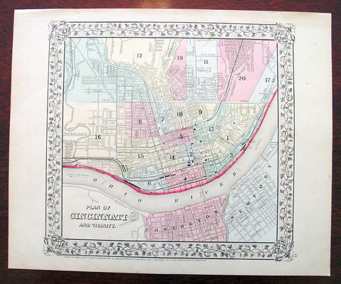
1869 Mitchell Antique Map - Plan of The City of Cincinnati
- Title : Plan of Cincinnati and Vicinity....1869 by S. Augustus Mitchell
- Ref #: 35044
- Size: 15in x 12in (380mm x 300mm)
- Date : 1870
- Condition: (A+) Fine Condition
Description:
This beautifully hand coloured original antique city plan map was published by Samuel Augustus Mitchell in the 1870 edition of his large New General Atlas - dated at the foot of the map.
These county, state, city & country maps are some of the most ornate and beautifully coloured maps published in the US in the 19th century. For over 50 years, Mitchell his son's and their successors were the most prominent cartographical publishers of maps and atlases in the United States.
General Description:
Paper thickness and quality: - Heavy & stable
Paper color: - White
Age of map color: - Original
Colors used: - Green, pink, yellow
General color appearance: - Authentic
Paper size: - 15in x 12in (380mm x 300mm)
Plate size: - 15in x 12in (380mm x 300mm)
Margins: - Min 1/2in (10mm)
Imperfections:
Margins: - None
Plate area: - None
Verso: - None
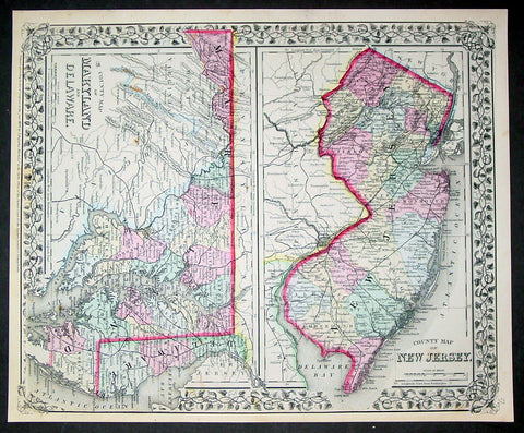
1870 Samuel Augustus Mitchell County Antique Maps New Jersey, Maryland, Delaware
- Title : County Map of New Jersey; County Map of Maryland and Delaware....1870 by S. Augustus Mitchell
- Ref #: 35033
- Size: 15in x 12in (380mm x 300mm)
- Date : 1870
- Condition: (A+) Fine Condition
Description:
This beautifully hand coloured original antique map was published by Samuel Augustus Mitchell in the 1870 edition of his large New General Atlas - dated at the foot of the map.
These county, state, city & country maps are some of the most ornate and beautifully coloured maps published in the US in the 19th century. For over 50 years, Mitchell his son's and their successors were the most prominent cartographical publishers of maps and atlases in the United States.
General Description:
Paper thickness and quality: - Heavy & stable
Paper color: - White
Age of map color: - Original
Colors used: - Green, pink, yellow
General color appearance: - Authentic
Paper size: - 15in x 12in (380mm x 300mm)
Plate size: - 15in x 12in (380mm x 300mm)
Margins: - Min 1/2in (10mm)
Imperfections:
Margins: - None
Plate area: - None
Verso: - None

1870 Samuel Augustus Mitchell County Antique Map of Virginia & West Virginia
- Title : County Map of Virginia and West Virginia....1870 by S. Augustus Mitchell
- Ref #: 35036
- Size: 15in x 12in (380mm x 300mm)
- Date : 1870
- Condition: (A+) Fine Condition
Description:
This beautifully hand coloured original antique map was published by Samuel Augustus Mitchell in the 1870 edition of his large New General Atlas - dated at the foot of the map.
These county, state, city & country maps are some of the most ornate and beautifully coloured maps published in the US in the 19th century. For over 50 years, Mitchell his son's and their successors were the most prominent cartographical publishers of maps and atlases in the United States.
General Description:
Paper thickness and quality: - Heavy & stable
Paper color: - White
Age of map color: - Original
Colors used: - Green, pink, yellow
General color appearance: - Authentic
Paper size: - 15in x 12in (380mm x 300mm)
Plate size: - 15in x 12in (380mm x 300mm)
Margins: - Min 1/2in (10mm)
Imperfections:
Margins: - None
Plate area: - None
Verso: - None

1870 Samuel Augustus Mitchell Antique County Map of Iowa and Missouri
- Title : County Map of the States of Iowa and Missouri....1870 by S. Augustus Mitchell
- Ref #: 35047
- Size: 15in x 12in (380mm x 300mm)
- Date : 1870
- Condition: (A+) Fine Condition
Description:
This beautifully hand coloured original antique map was published by Samuel Augustus Mitchell in the 1870 edition of his large New General Atlas - dated at the foot of the map.
These county, state, city & country maps are some of the most ornate and beautifully coloured maps published in the US in the 19th century. For over 50 years, Mitchell his son's and their successors were the most prominent cartographical publishers of maps and atlases in the United States.
General Description:
Paper thickness and quality: - Heavy & stable
Paper color: - White
Age of map color: - Original
Colors used: - Green, pink, yellow
General color appearance: - Authentic
Paper size: - 15in x 12in (380mm x 300mm)
Plate size: - 15in x 12in (380mm x 300mm)
Margins: - Min 1/2in (10mm)
Imperfections:
Margins: - None
Plate area: - None
Verso: - None
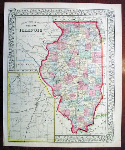
1869 Mitchell Antique Map of The State of Illinois
- Title : County Map of the State of Illinois....1869 by S. Augustus Mitchell
- Ref #: 35045
- Size: 15in x 12in (380mm x 300mm)
- Date : 1870
- Condition: (A+) Fine Condition
Description:
This beautifully hand coloured original antique map was published by Samuel Augustus Mitchell in the 1870 edition of his large New General Atlas - dated at the foot of the map.
These county, state, city & country maps are some of the most ornate and beautifully coloured maps published in the US in the 19th century. For over 50 years, Mitchell his son's and their successors were the most prominent cartographical publishers of maps and atlases in the United States.
General Description:
Paper thickness and quality: - Heavy & stable
Paper color: - White
Age of map color: - Original
Colors used: - Green, pink, yellow
General color appearance: - Authentic
Paper size: - 15in x 12in (380mm x 300mm)
Plate size: - 15in x 12in (380mm x 300mm)
Margins: - Min 1/2in (10mm)
Imperfections:
Margins: - None
Plate area: - None
Verso: - None
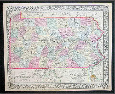
1870 Samuel Augustus Mitchell County Antique Map of the State of Pennsylvania
- Title : County Map of Florida, Mobile....1870 by S. Augustus Mitchell
- Ref #: 35051
- Size: 15in x 12in (380mm x 300mm)
- Date : 1870
- Condition: (A+) Fine Condition
Description:
This beautifully hand coloured original antique map was published by Samuel Augustus Mitchell in the 1870 edition of his large New General Atlas - dated at the foot of the map.
These county, state, city & country maps are some of the most ornate and beautifully coloured maps published in the US in the 19th century. For over 50 years, Mitchell his son's and their successors were the most prominent cartographical publishers of maps and atlases in the United States.
General Description:
Paper thickness and quality: - Heavy & stable
Paper color: - White
Age of map color: - Original
Colors used: - Green, pink, yellow
General color appearance: - Authentic
Paper size: - 15in x 12in (380mm x 300mm)
Plate size: - 15in x 12in (380mm x 300mm)
Margins: - Min 1/2in (10mm)
Imperfections:
Margins: - None
Plate area: - None
Verso: - None
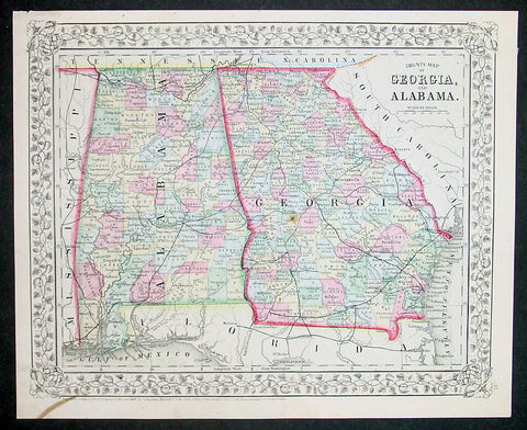
1870 Samuel Augustus Mitchell County Antique Map of Georgia and Alabama
- Title : County Map of Georgia and Alabama....1870 by S. Augustus Mitchell
- Ref #: 35038
- Size: 15in x 12in (380mm x 300mm)
- Date : 1870
- Condition: (A+) Fine Condition
Description:
This beautifully hand coloured original antique map was published by Samuel Augustus Mitchell in the 1870 edition of his large New General Atlas - dated at the foot of the map.
These county, state, city & country maps are some of the most ornate and beautifully coloured maps published in the US in the 19th century. For over 50 years, Mitchell his son's and their successors were the most prominent cartographical publishers of maps and atlases in the United States.
General Description:
Paper thickness and quality: - Heavy & stable
Paper color: - White
Age of map color: - Original
Colors used: - Green, pink, yellow
General color appearance: - Authentic
Paper size: - 15in x 12in (380mm x 300mm)
Plate size: - 15in x 12in (380mm x 300mm)
Margins: - Min 1/2in (10mm)
Imperfections:
Margins: - None
Plate area: - None
Verso: - None
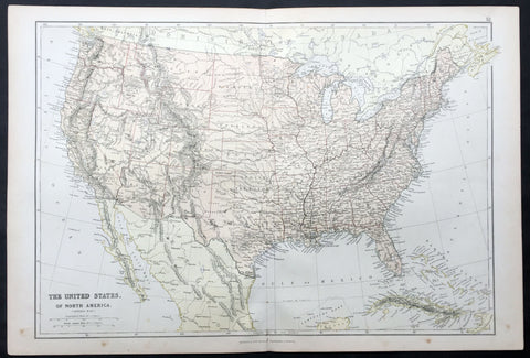
1870 Blackie & Son Large Antique Map of The United States of America
- Title : The United States of North America
- Ref #: 80558
- Size: 22in x 15in (560mm x 380mm)
- Date : 1870
- Condition: (A+) Fine Condition
Description:
This fine large original antique lithograph map of The United States of America was engraved by Edward Weller and published by Blackie & Son of Glasgow & London in the 1870 edition of the Geographical Atlas. (Ref: Tooley; M&B)
General Description:
Paper thickness and quality: - Heavy and stable
Paper colour: - off white
Age of map colour: - Original
Colours used: - Yellow, pink, green
General colour appearance: - Authentic
Paper size: - 22in x 15in (560mm x 380mm)
Margins: - min 1/4in (8mm)
Imperfections:
Margins: - None
Plate area: - None
Verso: - None
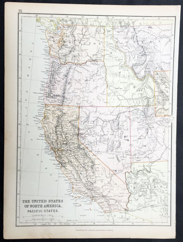
1870 Blackie & Son Antique Map The Western United States of America
- Title : The United States of North America Pacific States
- Ref #: 80560
- Size: 15in x 11in (380mm x 280mm)
- Date : 1870
- Condition: (A+) Fine Condition
Description:
This fine original antique lithograph map of the Western United States of America including Washington, Oregon, California, Arizona, Nevada, Idaho, Montana, Utah & part of Wyoming was engraved by Edward Weller andpublished by Blackie & Son of Glasgow in the1870 edition of the Geographical Atlas. (Ref: Tooley; M&B)
General Description:
Paper thickness and quality: - Heavy and stable
Paper colour: - off white
Age of map colour: - Original
Colours used: - Yellow, pink, green
General colour appearance: - Authentic
Paper size: - 15in x 11in (380mm x 280mm)
Margins: - min 1/2in (12mm)
Imperfections:
Margins: - None
Plate area: - None
Verso: - None
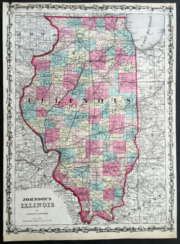
1860 A J Johnson Large Antique 1st edition Map of The State of Illinois, USA
- Title : Johnson's Illinois by Johnson & Browning
- Ref #: 50671
- Size: 17 1/2in x 13in (450mm x 330mm)
- Date : 1860
- Condition: (A) Very Good Condition
Description:
This finely engraved beautifully hand coloured original 1st edition map of the State of Illinois was published by A J Johnson in the 1860 edition ofJohnson's New Illustrated Family Atlas.
Background:
1st Edition, 1st issue. Most of the maps in this atlas come from Colton's 1859 edition of the General Atlas, published by Johnson and Browning, indicating the Johnson connection; some do not come from this atlas, and their sources are: the New England maps (scale 1" = 9 miles) come from Colton's map of New England and then the sub-maps of Vermont and New Hampshire, Mass/Conn/R.I.; the Ohio/Indiana is still a mystery; all the 1" = 24 miles maps (Iowa, Kentucky, etc.) come from Colton's Map of the United States and the Canadas, originally published by J. Calvin Smith in 1843 (see W. Heckrotte's copies and his list of editions); and the Colton General Atlas maps used by Johnson come from Colton's Travellers Series of maps - see our copies of Penn., Indiana. Colton mentions "The National Atlas of the United States, constructed from the Public Surveys..large Folio" as in preparation in his 1855 catalogue; this may be the embryonic Johnson Atlas. Colton used his wall maps "cut up" for pocket maps and Atlases. Johnson's maps of S. America, Europe, Africa, and (in the first edition, first issue, only) China, East Indies etc., all come from D. Griffing Johnson's Map of the World, 1847. These atlas maps are updated (esp. Africa). Colton took over the publication of the World Map in 1849, issued editions to 1868 (Ristow p318). Also, Johnson's N. America map is the inset N. America in Smith's Map of the U.S., the Canadas, etc. This first issue of Johnson's Family Atlas differs from the later 1860 edition in a small N.Y. (from the Colton U.S. map), small Texas, and many of the maps have fewer views or no views or different configurations. Clearly, this was a first attempt that was refined later in the year. Another issue of this same edition was published in Richmond, Virginia, the home town of Browning (I.L.). The California map originates with Johnson's New Illustrated and Embellished County
General Description:
Paper thickness and quality: - Heavy & stable
Paper color: - White
Age of map color: - Original
Colors used: - Pink green yellow
General color appearance: - Authentic
Paper size: - 17 1/2in x 13in (450mm x 330mm)
Plate size: - 17 1/2in x 13in (450mm x 330mm)
Margins: - Min 1/4in 312mm)
Imperfections:
Margins: - Uniform age toning, light chipping to margin edges
Plate area: - None
Verso: - Uniform age toning
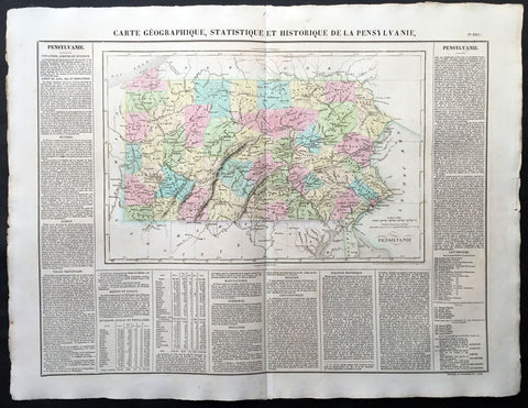
1825 Carey & Lea, Buchon Large Antique Map of the State of Pennsylvania, USA
-
Title : Carte Geographique, Statistique et Historique De la Pensylvanie
- Ref #: 70012
- Size: 27 1/2in x 21 1/2in (700mm x 545mm)
- Date : 1825
- Condition: (A+) Fine Condition
Description:
This large beautifully hand coloured original antique map was published in the 1825 French edition of Carey & Lea's American Atlas by Jean Alexandre Buchon.
This map is in exceptionally fine condition, on clean, sturdy and stable heavy paper, heavy engraving and beautiful original hand colour.
In 1822, Henry Charles Carey and Isaac Lea published their American Atlas. This volume was based on Emmanuel Las Cases' Atlas Historique of 1803, with updated maps and text modified by Carey, a political economist.
He considered himself an American foil to John Stuart Mill and the London economists who were proclaimers of "the gloomy science" influenced by Ricardo and Malthus. Instead of preaching overpopulation and degeneration of the human species, Carey illustrated the nations of the western hemisphere through maps that showed an expanding region with ample promise of developing into lands of great new opportunity and growth. The sheets from this atlas, which cover North America, Central America, South America and the West Indies, are comprised of an engraved map surrounded by text documenting the history, climate, population and so forth of the area depicted. The atlas is particularly known for its excellent early maps of the states and territories of the United States. Many of these maps were drawn by Fielding Lucas, Jr., an important Baltimore cartographer. All of the maps show excellent and very up-to-date detail, providing fine verbal and graphic pictures of states and territories in the early 19th century (Ref: M&B; Tooley)
General Description:
Paper thickness and quality: - Heavy and stable
Paper color: - white
Age of map color: - Original
Colors used: - Yellow, green, blue, pink
General color appearance: - Authentic
Paper size: - 27 1/2in x 21 1/2in (700mm x 545mm)
Margins: - min. 1in (25mm)
Imperfections:
Margins: - Light age toning
Plate area: Light age toning
Verso: - Light age toning
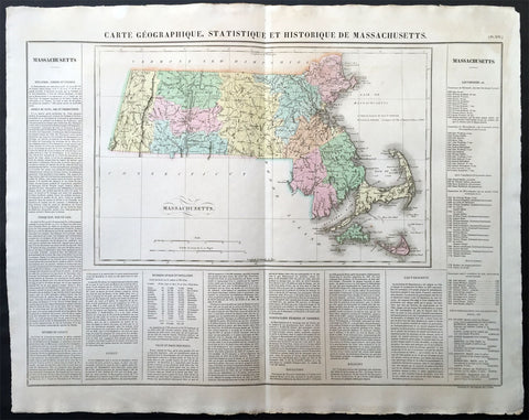
1825 Carey & Lea, Buchon Large Antique Map of the State of Massachusetts, USA
-
Title : Carte Geographique, Statistique et Historique Du Massachusetts
- Ref #: 70007
- Size: 27 1/2in x 21 1/2in (700mm x 545mm)
- Date : 1825
- Condition: (A+) Fine Condition
Description:
This large beautifully hand coloured original antique map was published in the 1825 French edition of Carey & Lea's American Atlas by Jean Alexandre Buchon.
This map is in exceptionally fine condition, on clean, sturdy and stable heavy paper, heavy engraving and beautiful original hand colour.
In 1822, Henry Charles Carey and Isaac Lea published their American Atlas. This volume was based on Emmanuel Las Cases' Atlas Historique of 1803, with updated maps and text modified by Carey, a political economist.
He considered himself an American foil to John Stuart Mill and the London economists who were proclaimers of "the gloomy science" influenced by Ricardo and Malthus. Instead of preaching overpopulation and degeneration of the human species, Carey illustrated the nations of the western hemisphere through maps that showed an expanding region with ample promise of developing into lands of great new opportunity and growth. The sheets from this atlas, which cover North America, Central America, South America and the West Indies, are comprised of an engraved map surrounded by text documenting the history, climate, population and so forth of the area depicted. The atlas is particularly known for its excellent early maps of the states and territories of the United States. Many of these maps were drawn by Fielding Lucas, Jr., an important Baltimore cartographer. All of the maps show excellent and very up-to-date detail, providing fine verbal and graphic pictures of states and territories in the early 19th century (Ref: M&B; Tooley)
General Description:
Paper thickness and quality: - Heavy and stable
Paper color: - white
Age of map color: - Original
Colors used: - Yellow, green, blue, pink
General color appearance: - Authentic
Paper size: - 27 1/2in x 21 1/2in (700mm x 545mm)
Margins: - min. 1in (25mm)
Imperfections:
Margins: - None
Plate area: None
Verso: - None
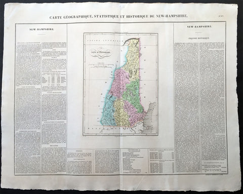
1825 Carey & Lea Buchon Large Antique Map of the State of New Hampshire, USA
-
Title : Carte Geographique, Statistique et Historique De New-Hampshire
- Ref #: 70006
- Size: 27 1/2in x 21 1/2in (700mm x 545mm)
- Date : 1825
- Condition: (A+) Fine Condition
Description:
This large beautifully hand coloured original antique map was published in the 1825 French edition of Carey & Lea's American Atlas by Jean Alexandre Buchon.
This map is in exceptionally fine condition, on clean, sturdy and stable heavy paper, heavy engraving and beautiful original hand colour.
In 1822, Henry Charles Carey and Isaac Lea published their American Atlas. This volume was based on Emmanuel Las Cases' Atlas Historique of 1803, with updated maps and text modified by Carey, a political economist.
He considered himself an American foil to John Stuart Mill and the London economists who were proclaimers of "the gloomy science" influenced by Ricardo and Malthus. Instead of preaching overpopulation and degeneration of the human species, Carey illustrated the nations of the western hemisphere through maps that showed an expanding region with ample promise of developing into lands of great new opportunity and growth. The sheets from this atlas, which cover North America, Central America, South America and the West Indies, are comprised of an engraved map surrounded by text documenting the history, climate, population and so forth of the area depicted. The atlas is particularly known for its excellent early maps of the states and territories of the United States. Many of these maps were drawn by Fielding Lucas, Jr., an important Baltimore cartographer. All of the maps show excellent and very up-to-date detail, providing fine verbal and graphic pictures of states and territories in the early 19th century (Ref: M&B; Tooley)
General Description:
Paper thickness and quality: - Heavy and stable
Paper color: - white
Age of map color: - Original
Colors used: - Yellow, green, blue, pink
General color appearance: - Authentic
Paper size: - 27 1/2in x 21 1/2in (700mm x 545mm)
Margins: - min. 1in (25mm)
Imperfections:
Margins: - None
Plate area: None
Verso: - None
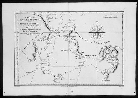
1788 Cook Raynal Antique Map of Alaska & The NW Passage
- Title : Carte De L Entree De Norton et Du Detroit de Bhering..Par M Bonne....
- Date : 1788
- Condition: (A+) Fine Condition
- Ref: 40575
- Size: 16 1/2in x 11 1/2in (420mm x 290mm)
Description:
This finely engraved original antique map of Capt James Cooks discoveries, surveys and depth soundings in the Bering Straits between Seward Peninsular & Norton Sound in Alaska and Chukotskiy Poluostrov Peninsula in Siberia Russia by Rigobert Bonne was published in the 1778 edition of Atllas des toutes les parties connues du globe terrestre by Guillaume Raynal. (Ref: Tooley; M&B)
General Description:
Paper thickness and quality: - Heavy and stable
Paper color: - off white
Age of map color: -
Colors used: -
General color appearance: -
Paper size: - 16 1/2in x 11 1/2in (420mm x 290mm)
Plate size: - 14 1/2in x 10in (370mm x 255mm)
Margins: - Min 1/2in (12mm)
Imperfections:
Margins: - Small worming to bottom margin
Plate area: - Two small worm holes adjacent to centerfold
Verso: - None