America (66)
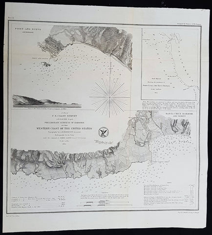
1854 A D Bache Antique Maps of Santa Cruz & Point Ano Nuevo Harbors, California
- Title : US Coast Survey A D Buache Supt Preliminary Survey of Harbors on the Western Coast of the United States...1854
- Size: 14 1/2in x 13 1/2in (370mm x 340mm)
- Condition: (A+) Fine Condition
- Date : 1854
- Ref #: 93015
Description:
This large rare, original lithograph early antique map of Santa Cruz and Point Ano Nuevo Harbors, California, by Alexander Dallas Bache (great-grandson of Benjamin Franklin) in 1857 - dated - was published by the official chart-maker of the United States, the office of The US Coast Survey.
The Office of the Coast Survey, founded in 1807 by President Thomas Jefferson and Secretary of Commerce Albert Gallatin, is the oldest scientific organization in the U.S. Federal Government. Jefferson created the Survey of the Coast, as it was then called, in response to a need for accurate navigational charts of the new nation\\\'s coasts and harbors.
General Definitions:
Paper thickness and quality: - Heavy and stable
Paper color : - off white
Age of map color: -
Colors used: -
General color appearance: -
Paper size: - 14 1/2in x 13 1/2in (370mm x 340mm)
Plate size: - 14 1/2in x 13 1/2in (370mm x 340mm)
Margins: - Min 1/2in (12mm)
Imperfections:
Margins: - None
Plate area: - Folds as issued, light age toning
Verso: - Some folds re-enforced with archival tape
Background:
Detailed map of Santa Cruz and Point Ano Nuevo, the latter with a profile view. The Santa Cruz Harbor map shows the town, Mission, San Lorenzo River, roads, etc., plus the plan of the harbor, Point Santa Cruz, and other details. Includes sailing information and tidal notes.
U.S. Coast Survey (Office of Coast Survey)
The Office of Coast Survey is the official chart-maker of the United States. Set up in 1807, it is one of the U.S. governments oldest scientific organizations. In 1878 it was given the name of Coast and Geodetic Survey (C&GS). In 1970 it became part of the National Oceanic and Atmospheric Administration (NOAA).
The agency was established in 1807 when President Thomas Jefferson signed the document entitled An act to provide for surveying the coasts of the United States. While the bills objective was specific—to produce nautical charts—it reflected larger issues of concern to the new nation: national boundaries, commerce, and defence.
The early years were difficult. Ferdinand Rudolph Hassler, who was eventually to become the agencys first superintendent, went to England to collect scientific instruments but was unable to return through the duration of the War of 1812. After his return, he worked on a survey of the New York Harbor in 1817, but Congress stepped in to suspend the work because of tensions between civilian and military control of the agency. After several years under the control of the U.S. Army, the Survey of the Coast was reestablished in 1832, and President Andrew Jackson appointed Hassler as superintendent.
The U.S. Coast Survey was a civilian agency but, from the beginning, members of the Navy and Army were detailed to service with the Survey, and Navy ships were also detailed to its use. In general, army officers worked on topographic surveys on the land and maps based on the surveys, while navy officers worked on hydrographic surveys in coastal waters.
Alexander Dallas Bache, great-grandson of Benjamin Franklin, was the second Coast Survey superintendent. Bache was a physicist, scientist, and surveyor who established the first magnetic observatory and served as the first president of the National Academy of Sciences. Under Bache, Coast Survey quickly applied its resources to the Union cause during the Civil War. In addition to setting up additional lithographic presses to produce the thousands of charts required by the Navy and other vessels, Bache made a critical decision to send Coast Survey parties to work with blockading squadrons and armies in the field, producing hundreds of maps and charts. Bache detailed these activities in his annual reports to Congress.
Coast Survey cartographer Edwin Hergesheimer created the map showing the density of the slave population in the Southern states.
Bache was also one of four members of the governments Blockade Strategy Board, planning strategy to essentially strangle the South, economically and militarily. On April 16, 1861, President Lincoln issued a proclamation declaring the blockade of ports from South Carolina to Texas. Baches Notes on the Coast provided valuable information for Union naval forces.
Maps were of paramount importance in wartime:
It is certain that accurate maps must form the basis of well-conducted military operations, and that the best time to procure them is not when an attack is impending, or when the army waits, but when there is no hindrance to, or pressure upon, the surveyors. That no coast can be effectively attacked, defended, or blockaded without accurate maps and charts, has been fully proved by the events of the last two years, if, indeed, such a proposition required practical proof.
— Alexander Dallas Bache, 1862 report.
Coast Survey attracted some of the best and brightest scientists and naturalists. It commissioned the naturalist Louis Agassiz to conduct the first scientific study of the Florida reef system. James McNeill Whistler, who went on to paint the iconic Whistlers Mother, was a Coast Survey engraver. The naturalist John Muir was a guide and artist on Survey of the 39th Parallel across the Great Basin of Nevada and Utah.
The agencys men and women (women professionals were hired as early as 1845) led scientific and engineering activities through the decades. In 1926, they started production of aeronautical charts. During the height of the Great Depression, Coast and Geodetic Survey organized surveying parties and field offices that employed over 10,000 people, including many out-of-work engineers.
In World War II, C&GS sent over 1,000 civilian members and more than half of its commissioned officers to serve as hydrographers, artillery surveyors, cartographers, army engineers, intelligence officers, and geophysicists in all theaters of the war. Civilians on the home front produced over 100 million maps and charts for the Allied Forces. Eleven members of the C&GS gave their lives during the war.
Alexander Dallas Bache 1806 – 1867 was an American physicist, scientist, and surveyor who erected coastal fortifications and conducted a detailed survey to map the mid-eastern United States coastline. Originally an army engineer, he later became Superintendent of the U.S. Coast Survey, and built it into the foremost scientific institution in the country before the Civil War.
Alexander Bache was born in Philadelphia, the son of Richard Bache, Jr., and Sophia Burrell Dallas Bache. He came from a prominent family as he was the nephew of Vice-President George M. Dallas and naval hero Alexander J. Dallas. He was the grandson of Secretary of the Treasury Alexander Dallas and was the great-grandson of Benjamin Franklin.
Bache was a professor of natural philosophy and chemistry at the University of Pennsylvania from 1828 to 1841 and again from 1842 to 1843. He spent 1836–1838 in Europe on behalf of the trustees of what became Girard College; he was named president of the college after his return. Abroad, he examined European education systems, and on his return he published a valuable report. From 1839 to 1842, he served as the first president of Central High School of Philadelphia, one of the oldest public high schools in the United States.
In 1843, on the death of Professor Ferdinand Rudolph Hassler, Bache was appointed superintendent of the United States Coast Survey. He convinced the United States Congress of the value of this work and, by means of the liberal aid it granted, he completed the mapping of the whole coast by a skillful division of labor and the erection of numerous observing stations. In addition, magnetic and meteorological data were collected. Bache served as head of the Coast Survey for 24 years (until his death).
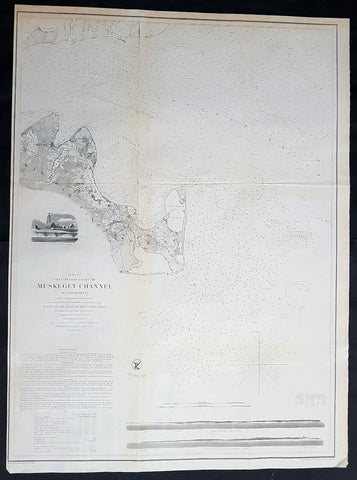
1854 A D Bache Large Rare Antique Map of Marthas Vineyard & Muskeget Channel, Massachusetts
- Title : Preliminary Chart of Muskeget Channel Massachusetts from a Trigonmetrical Survey . . . 1854
- Size: 29in x 21 1/2in (735mm x 545mm)
- Condition: (A+) Fine Condition
- Date : 1854
- Ref #: 93035
Description:
This large rare, original lithograph early antique map of Marthas Vineyard & the Muskeget Channel, Massachusetts - across to Falmouth Village - by Alexander Dallas Bache (great-grandson of Benjamin Franklin) in 1854 - dated - was published by the official chart-maker of the United States, the office of The US Coast Survey.
The Office of the Coast Survey, founded in 1807 by President Thomas Jefferson and Secretary of Commerce Albert Gallatin, is the oldest scientific organization in the U.S. Federal Government. Jefferson created the Survey of the Coast, as it was then called, in response to a need for accurate navigational charts of the new nation\'s coasts and harbors.
General Definitions:
Paper thickness and quality: - Heavy and stable
Paper color : - off white
Age of map color: -
Colors used: -
General color appearance: -
Paper size: - 29in x 21 1/2in (735mm x 545mm)
Plate size: - 29in x 21 1/2in (735mm x 545mm)
Margins: - Min 1/2in (12mm)
Imperfections:
Margins: - None
Plate area: - Folds as issued, light age toning
Verso: - Some folds re-enforced with archival tape
Background:
One of the better mid 19th century large format maps of Martha\'s Vineyard. This rare map depicts most of the island of Marthas Vineyard though does cut out its southwestern portion. Towns, villages, farms, and roads are all beautifully rendered. So too are nautical indications, oceanic depths, and undersea features. There are views of both Holmes\' Hole Harbor and the entrance to Muskeget Channel. There is also a Telescopic view of the Cape Poge lighthouse. This map was created under the direction of A. D. Bache, Superintendent of the Survey of the Coast of the United States and one of the most influential American cartographers of the 19th century.
U.S. Coast Survey (Office of Coast Survey)
The Office of Coast Survey is the official chart-maker of the United States. Set up in 1807, it is one of the U.S. governments oldest scientific organizations. In 1878 it was given the name of Coast and Geodetic Survey (C&GS). In 1970 it became part of the National Oceanic and Atmospheric Administration (NOAA).
The agency was established in 1807 when President Thomas Jefferson signed the document entitled An act to provide for surveying the coasts of the United States. While the bills objective was specific—to produce nautical charts—it reflected larger issues of concern to the new nation: national boundaries, commerce, and defence.
The early years were difficult. Ferdinand Rudolph Hassler, who was eventually to become the agencys first superintendent, went to England to collect scientific instruments but was unable to return through the duration of the War of 1812. After his return, he worked on a survey of the New York Harbor in 1817, but Congress stepped in to suspend the work because of tensions between civilian and military control of the agency. After several years under the control of the U.S. Army, the Survey of the Coast was reestablished in 1832, and President Andrew Jackson appointed Hassler as superintendent.
The U.S. Coast Survey was a civilian agency but, from the beginning, members of the Navy and Army were detailed to service with the Survey, and Navy ships were also detailed to its use. In general, army officers worked on topographic surveys on the land and maps based on the surveys, while navy officers worked on hydrographic surveys in coastal waters.
Alexander Dallas Bache, great-grandson of Benjamin Franklin, was the second Coast Survey superintendent. Bache was a physicist, scientist, and surveyor who established the first magnetic observatory and served as the first president of the National Academy of Sciences. Under Bache, Coast Survey quickly applied its resources to the Union cause during the Civil War. In addition to setting up additional lithographic presses to produce the thousands of charts required by the Navy and other vessels, Bache made a critical decision to send Coast Survey parties to work with blockading squadrons and armies in the field, producing hundreds of maps and charts. Bache detailed these activities in his annual reports to Congress.
Coast Survey cartographer Edwin Hergesheimer created the map showing the density of the slave population in the Southern states.
Bache was also one of four members of the governments Blockade Strategy Board, planning strategy to essentially strangle the South, economically and militarily. On April 16, 1861, President Lincoln issued a proclamation declaring the blockade of ports from South Carolina to Texas. Baches Notes on the Coast provided valuable information for Union naval forces.
Maps were of paramount importance in wartime:
It is certain that accurate maps must form the basis of well-conducted military operations, and that the best time to procure them is not when an attack is impending, or when the army waits, but when there is no hindrance to, or pressure upon, the surveyors. That no coast can be effectively attacked, defended, or blockaded without accurate maps and charts, has been fully proved by the events of the last two years, if, indeed, such a proposition required practical proof.
— Alexander Dallas Bache, 1862 report.
Coast Survey attracted some of the best and brightest scientists and naturalists. It commissioned the naturalist Louis Agassiz to conduct the first scientific study of the Florida reef system. James McNeill Whistler, who went on to paint the iconic Whistlers Mother, was a Coast Survey engraver. The naturalist John Muir was a guide and artist on Survey of the 39th Parallel across the Great Basin of Nevada and Utah.
The agencys men and women (women professionals were hired as early as 1845) led scientific and engineering activities through the decades. In 1926, they started production of aeronautical charts. During the height of the Great Depression, Coast and Geodetic Survey organized surveying parties and field offices that employed over 10,000 people, including many out-of-work engineers.
In World War II, C&GS sent over 1,000 civilian members and more than half of its commissioned officers to serve as hydrographers, artillery surveyors, cartographers, army engineers, intelligence officers, and geophysicists in all theaters of the war. Civilians on the home front produced over 100 million maps and charts for the Allied Forces. Eleven members of the C&GS gave their lives during the war.
Alexander Dallas Bache 1806 – 1867 was an American physicist, scientist, and surveyor who erected coastal fortifications and conducted a detailed survey to map the mid-eastern United States coastline. Originally an army engineer, he later became Superintendent of the U.S. Coast Survey, and built it into the foremost scientific institution in the country before the Civil War.
Alexander Bache was born in Philadelphia, the son of Richard Bache, Jr., and Sophia Burrell Dallas Bache. He came from a prominent family as he was the nephew of Vice-President George M. Dallas and naval hero Alexander J. Dallas. He was the grandson of Secretary of the Treasury Alexander Dallas and was the great-grandson of Benjamin Franklin.
Bache was a professor of natural philosophy and chemistry at the University of Pennsylvania from 1828 to 1841 and again from 1842 to 1843. He spent 1836–1838 in Europe on behalf of the trustees of what became Girard College; he was named president of the college after his return. Abroad, he examined European education systems, and on his return he published a valuable report. From 1839 to 1842, he served as the first president of Central High School of Philadelphia, one of the oldest public high schools in the United States.
In 1843, on the death of Professor Ferdinand Rudolph Hassler, Bache was appointed superintendent of the United States Coast Survey. He convinced the United States Congress of the value of this work and, by means of the liberal aid it granted, he completed the mapping of the whole coast by a skillful division of labor and the erection of numerous observing stations. In addition, magnetic and meteorological data were collected. Bache served as head of the Coast Survey for 24 years (until his death).
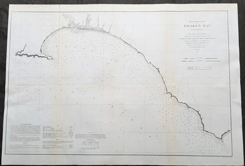
1860 A D Bache Large Rare Antique Map Drakes Bay, Puerto De Los Reyes California
- Title : Preliminary Chart of Drakes Bay, California From a Trigonometrical Survey under the Direction of A.D. Bache Superintendent of the Survey of the Coast of the United States....1860
- Size: 31 1/2in x 21 1/2in (850mm x 550mm)
- Condition: (A+) Fine Condition
- Date : 1860
- Ref #: 93042
Description:
This large rare, original antique lithograph early map of Drakes Bay or Puerto De Los Reyes on the Point Reyes national seashore in California, by Alexander Dallas Bache (great-grandson of Benjamin Franklin) in 1860 - dated - was published by the official chart-maker of the United States, the office of The US Coast Survey.
The Office of the Coast Survey, founded in 1807 by President Thomas Jefferson and Secretary of Commerce Albert Gallatin, is the oldest scientific organization in the U.S. Federal Government. Jefferson created the Survey of the Coast, as it was then called, in response to a need for accurate navigational charts of the new nation\'s coasts and harbors.
General Definitions:
Paper thickness and quality: - Heavy and stable
Paper color : - off white
Age of map color: -
Colors used: -
General color appearance: -
Paper size: - 31 1/2in x 21 1/2in (850mm x 550mm)
Plate size: - 31 1/2in x 21 1/2in (850mm x 550mm)
Margins: - Min 1/2in (12mm)
Imperfections:
Margins: - None
Plate area: - Folds as issued, light age toning
Verso: - Some folds re-enforced with archival tape
Background:
An uncommon 1860 map of Drakes Bay or Puerto De Los Reyes on the Point Reyes national seashore in California. Located approximately 30 miles northwest of San Francisco, Drakes Bay has long been considered the most likely landing site of the Englishman Sir Francis Drake on his historic 1579 circumnavigation of the world. The map extends from Point Reyes to Duxbury Reef and features numerous depth soundings and excellent inland topographical detail. A note in the lower left quadrant includes sailing directions and other useful information. The Geographical positioning for this chart was the work of George Davidson and A.F. Rodgers. The topography was accomplished by J. S. Lawson and A. F. Rodgers. The hydrography was completed by a party under the command of James Alden.
U.S. Coast Survey (Office of Coast Survey)
The Office of Coast Survey is the official chart-maker of the United States. Set up in 1807, it is one of the U.S. governments oldest scientific organizations. In 1878 it was given the name of Coast and Geodetic Survey (C&GS). In 1970 it became part of the National Oceanic and Atmospheric Administration (NOAA).
The agency was established in 1807 when President Thomas Jefferson signed the document entitled An act to provide for surveying the coasts of the United States. While the bills objective was specific—to produce nautical charts—it reflected larger issues of concern to the new nation: national boundaries, commerce, and defence.
The early years were difficult. Ferdinand Rudolph Hassler, who was eventually to become the agencys first superintendent, went to England to collect scientific instruments but was unable to return through the duration of the War of 1812. After his return, he worked on a survey of the New York Harbor in 1817, but Congress stepped in to suspend the work because of tensions between civilian and military control of the agency. After several years under the control of the U.S. Army, the Survey of the Coast was reestablished in 1832, and President Andrew Jackson appointed Hassler as superintendent.
The U.S. Coast Survey was a civilian agency but, from the beginning, members of the Navy and Army were detailed to service with the Survey, and Navy ships were also detailed to its use. In general, army officers worked on topographic surveys on the land and maps based on the surveys, while navy officers worked on hydrographic surveys in coastal waters.
Alexander Dallas Bache, great-grandson of Benjamin Franklin, was the second Coast Survey superintendent. Bache was a physicist, scientist, and surveyor who established the first magnetic observatory and served as the first president of the National Academy of Sciences. Under Bache, Coast Survey quickly applied its resources to the Union cause during the Civil War. In addition to setting up additional lithographic presses to produce the thousands of charts required by the Navy and other vessels, Bache made a critical decision to send Coast Survey parties to work with blockading squadrons and armies in the field, producing hundreds of maps and charts. Bache detailed these activities in his annual reports to Congress.
Coast Survey cartographer Edwin Hergesheimer created the map showing the density of the slave population in the Southern states.
Bache was also one of four members of the governments Blockade Strategy Board, planning strategy to essentially strangle the South, economically and militarily. On April 16, 1861, President Lincoln issued a proclamation declaring the blockade of ports from South Carolina to Texas. Baches Notes on the Coast provided valuable information for Union naval forces.
Maps were of paramount importance in wartime:
It is certain that accurate maps must form the basis of well-conducted military operations, and that the best time to procure them is not when an attack is impending, or when the army waits, but when there is no hindrance to, or pressure upon, the surveyors. That no coast can be effectively attacked, defended, or blockaded without accurate maps and charts, has been fully proved by the events of the last two years, if, indeed, such a proposition required practical proof.
— Alexander Dallas Bache, 1862 report.
Coast Survey attracted some of the best and brightest scientists and naturalists. It commissioned the naturalist Louis Agassiz to conduct the first scientific study of the Florida reef system. James McNeill Whistler, who went on to paint the iconic Whistlers Mother, was a Coast Survey engraver. The naturalist John Muir was a guide and artist on Survey of the 39th Parallel across the Great Basin of Nevada and Utah.
The agencys men and women (women professionals were hired as early as 1845) led scientific and engineering activities through the decades. In 1926, they started production of aeronautical charts. During the height of the Great Depression, Coast and Geodetic Survey organized surveying parties and field offices that employed over 10,000 people, including many out-of-work engineers.
In World War II, C&GS sent over 1,000 civilian members and more than half of its commissioned officers to serve as hydrographers, artillery surveyors, cartographers, army engineers, intelligence officers, and geophysicists in all theaters of the war. Civilians on the home front produced over 100 million maps and charts for the Allied Forces. Eleven members of the C&GS gave their lives during the war.
Alexander Dallas Bache 1806 – 1867 was an American physicist, scientist, and surveyor who erected coastal fortifications and conducted a detailed survey to map the mid-eastern United States coastline. Originally an army engineer, he later became Superintendent of the U.S. Coast Survey, and built it into the foremost scientific institution in the country before the Civil War.
Alexander Bache was born in Philadelphia, the son of Richard Bache, Jr., and Sophia Burrell Dallas Bache. He came from a prominent family as he was the nephew of Vice-President George M. Dallas and naval hero Alexander J. Dallas. He was the grandson of Secretary of the Treasury Alexander Dallas and was the great-grandson of Benjamin Franklin.
Bache was a professor of natural philosophy and chemistry at the University of Pennsylvania from 1828 to 1841 and again from 1842 to 1843. He spent 1836–1838 in Europe on behalf of the trustees of what became Girard College; he was named president of the college after his return. Abroad, he examined European education systems, and on his return he published a valuable report. From 1839 to 1842, he served as the first president of Central High School of Philadelphia, one of the oldest public high schools in the United States.
In 1843, on the death of Professor Ferdinand Rudolph Hassler, Bache was appointed superintendent of the United States Coast Survey. He convinced the United States Congress of the value of this work and, by means of the liberal aid it granted, he completed the mapping of the whole coast by a skillful division of labor and the erection of numerous observing stations. In addition, magnetic and meteorological data were collected. Bache served as head of the Coast Survey for 24 years (until his death).
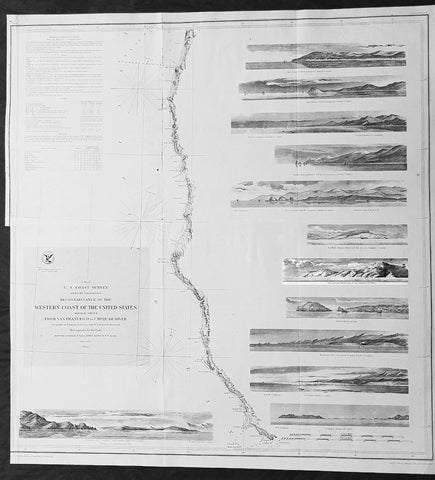
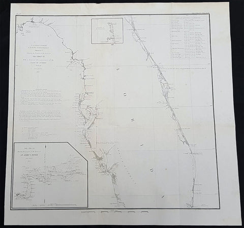
1854 A D Bache Large Rare Antique Map of San Francisco California to Umpqua River, Oregon
- Title : US Coast Survey A D Bache Super. Reconnaissance of the Western Coast of the United States Middle Sheet From San Francisco To Umpquah River . . . 1854
- Size: 24in x 22 1/2in (610mm x 570mm)
- Condition: (A+) Fine Condition
- Date : 1854
- Ref #: 93036
Description:
This large rare, original antique lithograph early map of the coastline from San Francisco, California and the Umpqua River, Oregon, by Alexander Dallas Bache (great-grandson of Benjamin Franklin) in 1854 - dated - was published by the official chart-maker of the United States, the office of The US Coast Survey.
The Office of the Coast Survey, founded in 1807 by President Thomas Jefferson and Secretary of Commerce Albert Gallatin, is the oldest scientific organization in the U.S. Federal Government. Jefferson created the Survey of the Coast, as it was then called, in response to a need for accurate navigational charts of the new nation\'s coasts and harbors.
Background:
A remarkable 1854 map by the United States Coast Survey. Covers the coastline of California and Oregon from San Francisco (depicted) northwards as far as the Umpqua (Umpquah) River. Offers soundings only along the coast line - suggesting the primitive state of the survey in this region. The highlight of this map are the twelve stunning coastal profile views that decorate the right hand side of the map. The upper left quadrant offers general information on tides and lighthouses as well as detailed sailing instructions for the region. This chart is the central sheet of a series of three charts that the Coast Survey issues to show its progress in the region. The positioning for this chart is the world of G. Davidson.
Profile views include Cape Arago, Cape Blanco, Robers River, Mark\'s Arch and Reef, Crescent City, Red Bluff, Cape Mendocino, Trinidad Head and City, Mendocino Cove, Pt. Arena, Pt. Reys, and the Entrance to San Francisco Bay.
Born in England, George Davidson (1825-1911) emigrated to the United States in 1832. After graduating from Girard College in Philadelphia, in 1845 he began a five-decade career with the United States Coast Survey. Much of his work was on the West Coast, where among many, many accomplishments he oversaw triangulation and geodetic work in the region, surveyed the Yolo and Los Angeles base lines, authored the Coast Pilot of California, Oregon and Washington and Coast Pilot of Alaska, and founded the Davidson Observatory in San Francisco. Following his retirement from the Coast Survey in 1895, at the age of 70 he became the first professor of geography at Berkeley, where he taught until retiring in 1905.
General Definitions:
Paper thickness and quality: - Heavy and stable
Paper color : - off white
Age of map color: -
Colors used: -
General color appearance: -
Paper size: - 24in x 22 1/2in (610mm x 570mm)
Plate size: - 24in x 22 1/2in (610mm x 570mm)
Margins: - Min 0in (0mm)
Imperfections:
Margins: - Bottom left half of margin cropped
Plate area: - Folds as issued
Verso: - Some folds re-enforced with archival tape
U.S. Coast Survey (Office of Coast Survey)
The Office of Coast Survey is the official chart-maker of the United States. Set up in 1807, it is one of the U.S. governments oldest scientific organizations. In 1878 it was given the name of Coast and Geodetic Survey (C&GS). In 1970 it became part of the National Oceanic and Atmospheric Administration (NOAA).
The agency was established in 1807 when President Thomas Jefferson signed the document entitled An act to provide for surveying the coasts of the United States. While the bills objective was specific—to produce nautical charts—it reflected larger issues of concern to the new nation: national boundaries, commerce, and defence.
The early years were difficult. Ferdinand Rudolph Hassler, who was eventually to become the agencys first superintendent, went to England to collect scientific instruments but was unable to return through the duration of the War of 1812. After his return, he worked on a survey of the New York Harbor in 1817, but Congress stepped in to suspend the work because of tensions between civilian and military control of the agency. After several years under the control of the U.S. Army, the Survey of the Coast was reestablished in 1832, and President Andrew Jackson appointed Hassler as superintendent.
The U.S. Coast Survey was a civilian agency but, from the beginning, members of the Navy and Army were detailed to service with the Survey, and Navy ships were also detailed to its use. In general, army officers worked on topographic surveys on the land and maps based on the surveys, while navy officers worked on hydrographic surveys in coastal waters.
Alexander Dallas Bache, great-grandson of Benjamin Franklin, was the second Coast Survey superintendent. Bache was a physicist, scientist, and surveyor who established the first magnetic observatory and served as the first president of the National Academy of Sciences. Under Bache, Coast Survey quickly applied its resources to the Union cause during the Civil War. In addition to setting up additional lithographic presses to produce the thousands of charts required by the Navy and other vessels, Bache made a critical decision to send Coast Survey parties to work with blockading squadrons and armies in the field, producing hundreds of maps and charts. Bache detailed these activities in his annual reports to Congress.
Coast Survey cartographer Edwin Hergesheimer created the map showing the density of the slave population in the Southern states.
Bache was also one of four members of the governments Blockade Strategy Board, planning strategy to essentially strangle the South, economically and militarily. On April 16, 1861, President Lincoln issued a proclamation declaring the blockade of ports from South Carolina to Texas. Baches Notes on the Coast provided valuable information for Union naval forces.
Maps were of paramount importance in wartime:
It is certain that accurate maps must form the basis of well-conducted military operations, and that the best time to procure them is not when an attack is impending, or when the army waits, but when there is no hindrance to, or pressure upon, the surveyors. That no coast can be effectively attacked, defended, or blockaded without accurate maps and charts, has been fully proved by the events of the last two years, if, indeed, such a proposition required practical proof.
— Alexander Dallas Bache, 1862 report.
Coast Survey attracted some of the best and brightest scientists and naturalists. It commissioned the naturalist Louis Agassiz to conduct the first scientific study of the Florida reef system. James McNeill Whistler, who went on to paint the iconic Whistlers Mother, was a Coast Survey engraver. The naturalist John Muir was a guide and artist on Survey of the 39th Parallel across the Great Basin of Nevada and Utah.
The agencys men and women (women professionals were hired as early as 1845) led scientific and engineering activities through the decades. In 1926, they started production of aeronautical charts. During the height of the Great Depression, Coast and Geodetic Survey organized surveying parties and field offices that employed over 10,000 people, including many out-of-work engineers.
In World War II, C&GS sent over 1,000 civilian members and more than half of its commissioned officers to serve as hydrographers, artillery surveyors, cartographers, army engineers, intelligence officers, and geophysicists in all theaters of the war. Civilians on the home front produced over 100 million maps and charts for the Allied Forces. Eleven members of the C&GS gave their lives during the war.
Alexander Dallas Bache 1806 – 1867 was an American physicist, scientist, and surveyor who erected coastal fortifications and conducted a detailed survey to map the mid-eastern United States coastline. Originally an army engineer, he later became Superintendent of the U.S. Coast Survey, and built it into the foremost scientific institution in the country before the Civil War.
Alexander Bache was born in Philadelphia, the son of Richard Bache, Jr., and Sophia Burrell Dallas Bache. He came from a prominent family as he was the nephew of Vice-President George M. Dallas and naval hero Alexander J. Dallas. He was the grandson of Secretary of the Treasury Alexander Dallas and was the great-grandson of Benjamin Franklin.
Bache was a professor of natural philosophy and chemistry at the University of Pennsylvania from 1828 to 1841 and again from 1842 to 1843. He spent 1836–1838 in Europe on behalf of the trustees of what became Girard College; he was named president of the college after his return. Abroad, he examined European education systems, and on his return he published a valuable report. From 1839 to 1842, he served as the first president of Central High School of Philadelphia, one of the oldest public high schools in the United States.
In 1843, on the death of Professor Ferdinand Rudolph Hassler, Bache was appointed superintendent of the United States Coast Survey. He convinced the United States Congress of the value of this work and, by means of the liberal aid it granted, he completed the mapping of the whole coast by a skillful division of labor and the erection of numerous observing stations. In addition, magnetic and meteorological data were collected. Bache served as head of the Coast Survey for 24 years (until his death).
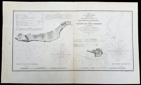
1855 A D Bache Rare Antique Map Santa Barbara &San Pedro, Los Angeles California
- Title : US Coast Survey A D Bache Super. Prelimanary Survey of San Pedro Anchorage and Vicinty of Santa Barbara California....1855
- Size: 16 1/2in x 10n (405mm x 255mm)
- Condition: (A+) Fine Condition
- Date : 1855
- Ref #: 93010
Description:
This rare, original antique lithograph early maps of Santa Barbara and San Pedro (Los Angeles), California, by Alexander Dallas Bache (great-grandson of Benjamin Franklin) in 1856 - dated - was published by the official chart-maker of the United States, the office of The US Coast Survey.
The Office of the Coast Survey, founded in 1807 by President Thomas Jefferson and Secretary of Commerce Albert Gallatin, is the oldest scientific organization in the U.S. Federal Government. Jefferson created the Survey of the Coast, as it was then called, in response to a need for accurate navigational charts of the new nation\'s coasts and harbors.
General Definitions:
Paper thickness and quality: - Heavy and stable
Paper color : - off white
Age of map color: -
Colors used: -
General color appearance: -
Paper size: - 16 1/2in x 10n (405mm x 255mm)
Plate size: - 16 1/2in x 10n (405mm x 255mm)
Margins: - Min 1/2in (12mm)
Imperfections:
Margins: - None
Plate area: - Folds as issued
Verso: - Some folds re-enforced with archival tape
Background:
An uncommon example of the 1855 U.S. Coast Survey nautical chart or maritime map of Santa Barbara and San Pedro (Los Angeles), California. Essentially two maps on a single sheet, the left hand map details the stretch of land that would evolve into the city of Santa Barbara. When the Coast Survey issued this map Santa Barbara was, for all intent and purposes, uninhabited. The right hand map focuses on Point Fermin and the San Pedro Anchorage. When this map was issued the mission and landing at San Pedro had been established, as had the Los Angeles Mission further north. Today the modern city of Los Angeles incorporates this entire area. As a nautical map it further includes countless depth soundings (in feet) and a wealth of practical information for the mariner. The triangulation for this map was completed by G. Davidson. The topography is the word of A. M. Harrison and W. M Johnson. The hydrography was accomplished by a team under the command of J. Alden. The whole was compiled under the direction of A. D. Bache, one of the U.S. Coast Survey\'s most influential and prolific superintendents, for issue in the 1855 annual report to Congress.
U.S. Coast Survey (Office of Coast Survey)
The Office of Coast Survey is the official chart-maker of the United States. Set up in 1807, it is one of the U.S. governments oldest scientific organizations. In 1878 it was given the name of Coast and Geodetic Survey (C&GS). In 1970 it became part of the National Oceanic and Atmospheric Administration (NOAA).
The agency was established in 1807 when President Thomas Jefferson signed the document entitled An act to provide for surveying the coasts of the United States. While the bills objective was specific—to produce nautical charts—it reflected larger issues of concern to the new nation: national boundaries, commerce, and defence.
The early years were difficult. Ferdinand Rudolph Hassler, who was eventually to become the agencys first superintendent, went to England to collect scientific instruments but was unable to return through the duration of the War of 1812. After his return, he worked on a survey of the New York Harbor in 1817, but Congress stepped in to suspend the work because of tensions between civilian and military control of the agency. After several years under the control of the U.S. Army, the Survey of the Coast was reestablished in 1832, and President Andrew Jackson appointed Hassler as superintendent.
The U.S. Coast Survey was a civilian agency but, from the beginning, members of the Navy and Army were detailed to service with the Survey, and Navy ships were also detailed to its use. In general, army officers worked on topographic surveys on the land and maps based on the surveys, while navy officers worked on hydrographic surveys in coastal waters.
Alexander Dallas Bache, great-grandson of Benjamin Franklin, was the second Coast Survey superintendent. Bache was a physicist, scientist, and surveyor who established the first magnetic observatory and served as the first president of the National Academy of Sciences. Under Bache, Coast Survey quickly applied its resources to the Union cause during the Civil War. In addition to setting up additional lithographic presses to produce the thousands of charts required by the Navy and other vessels, Bache made a critical decision to send Coast Survey parties to work with blockading squadrons and armies in the field, producing hundreds of maps and charts. Bache detailed these activities in his annual reports to Congress.
Coast Survey cartographer Edwin Hergesheimer created the map showing the density of the slave population in the Southern states.
Bache was also one of four members of the governments Blockade Strategy Board, planning strategy to essentially strangle the South, economically and militarily. On April 16, 1861, President Lincoln issued a proclamation declaring the blockade of ports from South Carolina to Texas. Baches Notes on the Coast provided valuable information for Union naval forces.
Maps were of paramount importance in wartime:
It is certain that accurate maps must form the basis of well-conducted military operations, and that the best time to procure them is not when an attack is impending, or when the army waits, but when there is no hindrance to, or pressure upon, the surveyors. That no coast can be effectively attacked, defended, or blockaded without accurate maps and charts, has been fully proved by the events of the last two years, if, indeed, such a proposition required practical proof.
— Alexander Dallas Bache, 1862 report.
Coast Survey attracted some of the best and brightest scientists and naturalists. It commissioned the naturalist Louis Agassiz to conduct the first scientific study of the Florida reef system. James McNeill Whistler, who went on to paint the iconic Whistlers Mother, was a Coast Survey engraver. The naturalist John Muir was a guide and artist on Survey of the 39th Parallel across the Great Basin of Nevada and Utah.
The agencys men and women (women professionals were hired as early as 1845) led scientific and engineering activities through the decades. In 1926, they started production of aeronautical charts. During the height of the Great Depression, Coast and Geodetic Survey organized surveying parties and field offices that employed over 10,000 people, including many out-of-work engineers.
In World War II, C&GS sent over 1,000 civilian members and more than half of its commissioned officers to serve as hydrographers, artillery surveyors, cartographers, army engineers, intelligence officers, and geophysicists in all theaters of the war. Civilians on the home front produced over 100 million maps and charts for the Allied Forces. Eleven members of the C&GS gave their lives during the war.
Alexander Dallas Bache 1806 – 1867 was an American physicist, scientist, and surveyor who erected coastal fortifications and conducted a detailed survey to map the mid-eastern United States coastline. Originally an army engineer, he later became Superintendent of the U.S. Coast Survey, and built it into the foremost scientific institution in the country before the Civil War.
Alexander Bache was born in Philadelphia, the son of Richard Bache, Jr., and Sophia Burrell Dallas Bache. He came from a prominent family as he was the nephew of Vice-President George M. Dallas and naval hero Alexander J. Dallas. He was the grandson of Secretary of the Treasury Alexander Dallas and was the great-grandson of Benjamin Franklin.
Bache was a professor of natural philosophy and chemistry at the University of Pennsylvania from 1828 to 1841 and again from 1842 to 1843. He spent 1836–1838 in Europe on behalf of the trustees of what became Girard College; he was named president of the college after his return. Abroad, he examined European education systems, and on his return he published a valuable report. From 1839 to 1842, he served as the first president of Central High School of Philadelphia, one of the oldest public high schools in the United States.
In 1843, on the death of Professor Ferdinand Rudolph Hassler, Bache was appointed superintendent of the United States Coast Survey. He convinced the United States Congress of the value of this work and, by means of the liberal aid it granted, he completed the mapping of the whole coast by a skillful division of labor and the erection of numerous observing stations. In addition, magnetic and meteorological data were collected. Bache served as head of the Coast Survey for 24 years (until his death).
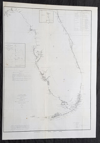
1856 A D Bache Large Rare Antique Map of Florida - US Coast Survey
- Title : US Coast Survey A D Bache Super. Sketch F Showing the Progress of the Survey in Section VI 1848-56...1856
- Size: 18 1/2in x 18 1/2in (470mm x 470mm)
- Condition: (A+) Fine Condition
- Date : 1856
- Ref #: 93021
Description:
This large, rare, original antique lithograph early map of Florida and the progress of the surveys since 1848, also the triangulation of the St Johns River, by Alexander Dallas Bache (great-grandson of Benjamin Franklin) in 1856 - dated - was published by the official chart-maker of the United States, the office of The US Coast Survey.
The Office of the Coast Survey, founded in 1807 by President Thomas Jefferson and Secretary of Commerce Albert Gallatin, is the oldest scientific organization in the U.S. Federal Government. Jefferson created the Survey of the Coast, as it was then called, in response to a need for accurate navigational charts of the new nation\'s coasts and harbors.
General Definitions:
Paper thickness and quality: - Heavy and stable
Paper color : - off white
Age of map color: -
Colors used: -
General color appearance: -
Paper size: - 18 1/2in x 18 1/2in (470mm x 470mm)
Plate size: - 18 1/2in x 18 1/2in (470mm x 470mm)
Margins: - Min 1/2in (12mm)
Imperfections:
Margins: - None
Plate area: - Folds as issued
Verso: - Some folds re-enforced with archival tape
Background:
Florida was the first region of the continental United States to be visited and settled by Europeans. The earliest known European explorers came with the Spanish conquistador Juan Ponce de León. Ponce de León spotted and landed on the peninsula on April 2, 1513. He named the region Florida (land of flowers) The story that he was searching for the Fountain of Youth is mythical and only appeared long after his death.
In May 1539, Conquistador Hernando de Soto skirted the coast of Florida, searching for a deep harbor to land. He described seeing a thick wall of red mangroves spread mile after mile, some reaching as high as 70 feet (21 m), with intertwined and elevated roots making landing difficult. The Spanish introduced Christianity, cattle, horses, sheep, the Castilian language, and more to Florida. Spain established several settlements in Florida, with varying degrees of success. In 1559, Don Tristán de Luna y Arellano established a settlement at present-day Pensacola, making it the first attempted settlement in Florida, but it was mostly abandoned by 1561.
In 1565, the settlement of St. Augustine (San Agustín) was established under the leadership of admiral and governor Pedro Menéndez de Avilés, creating what would become one of the oldest, continuously-occupied European settlements in the continental U.S. and establishing the first generation of Floridanos and the Government of Florida. Spain maintained strategic control over the region by converting the local tribes to Christianity. The marriage between Luisa de Abrego, a free black domestic servant from Seville, and Miguel Rodríguez, a white Segovian, occurred in 1565 in St. Augustine. It is the first recorded Christian marriage in the continental United States.
Some Spanish married or had unions with Pensacola, Creek or African women, both slave and free, and their descendants created a mixed-race population of mestizos and mulattos. The Spanish encouraged slaves from the southern British colonies to come to Florida as a refuge, promising freedom in exchange for conversion to Catholicism. King Charles II of Spain issued a royal proclamation freeing all slaves who fled to Spanish Florida and accepted conversion and baptism. Most went to the area around St. Augustine, but escaped slaves also reached Pensacola. St. Augustine had mustered an all-black militia unit defending Spain as early as 1683.
The geographical area of Florida diminished with the establishment of English settlements to the north and French claims to the west. The English attacked St. Augustine, burning the city and its cathedral to the ground several times. Spain built the Castillo de San Marcos in 1672 and Fort Matanzas in 1742 to defend Floridas capital city from attacks, and to maintain its strategic position in the defense of the Captaincy General of Cuba and the Spanish West Indies.
Florida attracted numerous Africans and African Americans from adjacent British colonies who sought freedom from slavery. In 1738, Governor Manuel de Montiano established Fort Gracia Real de Santa Teresa de Mose near St. Augustine, a fortified town for escaped slaves to whom Montiano granted citizenship and freedom in return for their service in the Florida militia, and which became the first free black settlement legally sanctioned in North America.
In 1763, Spain traded Florida to the Kingdom of Great Britain for control of Havana, Cuba, which had been captured by the British during the Seven Years War. It was part of a large expansion of British territory following their victory in the Seven Years War. A large portion of the Floridano population left, taking along most of the remaining indigenous population to Cuba. The British soon constructed the Kings Road connecting St. Augustine to Georgia. The road crossed the St. Johns River at a narrow point called Wacca Pilatka, or the British name Cow Ford, ostensibly reflecting the fact that cattle were brought across the river there.
The British divided and consolidated the Florida provinces (Las Floridas) into East Florida and West Florida, a division the Spanish government kept after the brief British period. The British government gave land grants to officers and soldiers who had fought in the French and Indian War in order to encourage settlement. In order to induce settlers to move to Florida, reports of its natural wealth were published in England. A large number of British settlers who were described as being energetic and of good character moved to Florida, mostly coming from South Carolina, Georgia and England. There was also a group of settlers who came from the colony of Bermuda. This would be the first permanent English-speaking population in what is now Duval County, Baker County, St. Johns County and Nassau County. The British built good public roads and introduced the cultivation of sugar cane, indigo and fruits as well as the export of lumber.
The British governors were directed to call general assemblies as soon as possible in order to make laws for the Floridas, and in the meantime they were, with the advice of councils, to establish courts. This was the first introduction of the English-derived legal system which Florida still has today, including trial by jury, habeas corpus and county-based government. Neither East Florida nor West Florida sent any representatives to Philadelphia to draft the Declaration of Independence. Florida remained a Loyalist stronghold for the duration of the American Revolution.
Spain regained both East and West Florida after Britains defeat in the American Revolution and the subsequent Treaty of Versailles in 1783, and continued the provincial divisions until 1821.
Defense of Floridas northern border with the United States was minor during the second Spanish period. The region became a haven for escaped slaves and a base for Indian attacks against U.S. territories, and the U.S. pressed Spain for reform.
Americans of English descent and Americans of Scots-Irish descent began moving into northern Florida from the backwoods of Georgia and South Carolina. Though technically not allowed by the Spanish authorities and the Floridan government, they were never able to effectively police the border region and the backwoods settlers from the United States would continue to immigrate into Florida unchecked. These migrants, mixing with the already present British settlers who had remained in Florida since the British period, would be the progenitors of the population known as Florida Crackers.
These American settlers established a permanent foothold in the area and ignored Spanish authorities. The British settlers who had remained also resented Spanish rule, leading to a rebellion in 1810 and the establishment for ninety days of the so-called Free and Independent Republic of West Florida on September 23. After meetings beginning in June, rebels overcame the garrison at Baton Rouge (now in Louisiana), and unfurled the flag of the new republic: a single white star on a blue field. This flag would later become known as the Bonnie Blue Flag.
In 1810, parts of West Florida were annexed by proclamation of President James Madison, who claimed the region as part of the Louisiana Purchase. These parts were incorporated into the newly formed Territory of Orleans. The U.S. annexed the Mobile District of West Florida to the Mississippi Territory in 1812. Spain continued to dispute the area, though the United States gradually increased the area it occupied. In 1812, a group of settlers from Georgia, with de facto support from the U.S. federal government, attempted to overthrow the Floridan government in the province of East Florida. The settlers hoped to convince Floridans to join their cause and proclaim independence from Spain, but the settlers lost their tenuous support from the federal government and abandoned their cause by 1813.
Seminoles based in East Florida began raiding Georgia settlements, and offering havens for runaway slaves. The United States Army led increasingly frequent incursions into Spanish territory, including the 1817–1818 campaign against the Seminole Indians by Andrew Jackson that became known as the First Seminole War. The United States now effectively controlled East Florida. Control was necessary according to Secretary of State John Quincy Adams because Florida had become a derelict open to the occupancy of every enemy, civilized or savage, of the United States, and serving no other earthly purpose than as a post of annoyance to them.
Florida had become a burden to Spain, which could not afford to send settlers or garrisons. Madrid therefore decided to cede the territory to the United States through the Adams–Onís Treaty, which took effect in 1821. President James Monroe was authorized on March 3, 1821 to take possession of East Florida and West Florida for the United States and provide for initial governance. Andrew Jackson, on behalf of the U.S. federal government, served as a military commissioner with the powers of governor of the newly acquired territory for a brief period. On March 30, 1822, the U.S. Congress merged East Florida and part of West Florida into the Florida Territory.
By the early 1800s, Indian removal was a significant issue throughout the southeastern U.S. and also in Florida. In 1830, the U.S. Congress passed the Indian Removal Act and as settlement increased, pressure grew on the U.S. government to remove the Indians from Florida. Seminoles offered sanctuary to blacks, and these became known as the Black Seminoles, and clashes between whites and Indians grew with the influx of new settlers. In 1832, the Treaty of Paynes Landing promised to the Seminoles lands west of the Mississippi River if they agreed to leave Florida. Many Seminole left at this time.
Some Seminoles remained, and the U.S. Army arrived in Florida, leading to the Second Seminole War (1835–1842). Following the war, approximately 3,000 Seminole and 800 Black Seminole were removed to Indian Territory. A few hundred Seminole remained in Florida in the Everglades.
On March 3, 1845, only one day before the end of President John Tylers term in office, Florida became the 27th state to join the United States of America. The state was admitted as a slave state and ceased to be a sanctuary for runaway slaves. Initially its population grew slowly.
As European settlers continued to encroach on Seminole lands, and the United States intervened to move the remaining Seminoles to the West. The Third Seminole War (1855–58) resulted in the forced removal of most of the remaining Seminoles, although hundreds of Seminole Indians remained in the Everglades
American settlers began to establish cotton plantations in north Florida, which required numerous laborers, which they supplied by buying slaves in the domestic market. By 1860, Florida had only 140,424 people, of whom 44% were enslaved. There were fewer than 1,000 free African Americans before the American Civil War.
On January 10, 1861, nearly all delegates in the Florida Legislature approved an ordinance of secession, declaring Florida to be a sovereign and independent nation—an apparent reassertion to the preamble in Floridas Constitution of 1838, in which Florida agreed with Congress to be a Free and Independent State. Although not directly related to the issue of slavery, the ordinance declared Floridas secession from the Union, allowing it to become one of the founding members of the Confederate States, a looser union of states.
The Confederacy received little help from Florida; the 15,000 men it offered were generally sent elsewhere. Instead of men and manufactured goods, Florida did provide salt and, more importantly, beef to feed the Confederate armies. This was particularly important after 1864, when the Confederacy lost control of the Mississippi River, thereby losing access to Texas beef. The largest engagements in the state were the Battle of Olustee, on February 20, 1864, and the Battle of Natural Bridge, on March 6, 1865. Both were Confederate victories. The war ended in 1865.
Following the American Civil War, Floridas congressional representation was restored on June 25, 1868, albeit forcefully after Radical Reconstruction and the installation of unelected government officials under the final authority of federal military commanders. After the Reconstruction period ended in 1876, white Democrats regained power in the state legislature. In 1885, they created a new constitution, followed by statutes through 1889 that disfranchised most blacks and many poor whites.
Until the mid-20th century, Florida was the least populous state in the southern United States. In 1900, its population was only 528,542, of whom nearly 44% were African American, the same proportion as before the Civil War. The boll weevil devastated cotton crops.
Forty thousand blacks, roughly one-fifth of their 1900 population, left the state in the Great Migration. They left due to lynchings and racial violence, and for better opportunities. Disfranchisement for most African Americans in the state persisted until the Civil Rights Movement of the 1960s gained federal legislation in 1965 to enforce protection of their constitutional suffrage.
U.S. Coast Survey (Office of Coast Survey)
The Office of Coast Survey is the official chart-maker of the United States. Set up in 1807, it is one of the U.S. governments oldest scientific organizations. In 1878 it was given the name of Coast and Geodetic Survey (C&GS). In 1970 it became part of the National Oceanic and Atmospheric Administration (NOAA).
The agency was established in 1807 when President Thomas Jefferson signed the document entitled An act to provide for surveying the coasts of the United States. While the bills objective was specific—to produce nautical charts—it reflected larger issues of concern to the new nation: national boundaries, commerce, and defence.
The early years were difficult. Ferdinand Rudolph Hassler, who was eventually to become the agencys first superintendent, went to England to collect scientific instruments but was unable to return through the duration of the War of 1812. After his return, he worked on a survey of the New York Harbor in 1817, but Congress stepped in to suspend the work because of tensions between civilian and military control of the agency. After several years under the control of the U.S. Army, the Survey of the Coast was reestablished in 1832, and President Andrew Jackson appointed Hassler as superintendent.
The U.S. Coast Survey was a civilian agency but, from the beginning, members of the Navy and Army were detailed to service with the Survey, and Navy ships were also detailed to its use. In general, army officers worked on topographic surveys on the land and maps based on the surveys, while navy officers worked on hydrographic surveys in coastal waters.
Alexander Dallas Bache, great-grandson of Benjamin Franklin, was the second Coast Survey superintendent. Bache was a physicist, scientist, and surveyor who established the first magnetic observatory and served as the first president of the National Academy of Sciences. Under Bache, Coast Survey quickly applied its resources to the Union cause during the Civil War. In addition to setting up additional lithographic presses to produce the thousands of charts required by the Navy and other vessels, Bache made a critical decision to send Coast Survey parties to work with blockading squadrons and armies in the field, producing hundreds of maps and charts. Bache detailed these activities in his annual reports to Congress.
Coast Survey cartographer Edwin Hergesheimer created the map showing the density of the slave population in the Southern states.
Bache was also one of four members of the governments Blockade Strategy Board, planning strategy to essentially strangle the South, economically and militarily. On April 16, 1861, President Lincoln issued a proclamation declaring the blockade of ports from South Carolina to Texas. Baches Notes on the Coast provided valuable information for Union naval forces.
Maps were of paramount importance in wartime:
It is certain that accurate maps must form the basis of well-conducted military operations, and that the best time to procure them is not when an attack is impending, or when the army waits, but when there is no hindrance to, or pressure upon, the surveyors. That no coast can be effectively attacked, defended, or blockaded without accurate maps and charts, has been fully proved by the events of the last two years, if, indeed, such a proposition required practical proof.
— Alexander Dallas Bache, 1862 report.
Coast Survey attracted some of the best and brightest scientists and naturalists. It commissioned the naturalist Louis Agassiz to conduct the first scientific study of the Florida reef system. James McNeill Whistler, who went on to paint the iconic Whistlers Mother, was a Coast Survey engraver. The naturalist John Muir was a guide and artist on Survey of the 39th Parallel across the Great Basin of Nevada and Utah.
The agencys men and women (women professionals were hired as early as 1845) led scientific and engineering activities through the decades. In 1926, they started production of aeronautical charts. During the height of the Great Depression, Coast and Geodetic Survey organized surveying parties and field offices that employed over 10,000 people, including many out-of-work engineers.
In World War II, C&GS sent over 1,000 civilian members and more than half of its commissioned officers to serve as hydrographers, artillery surveyors, cartographers, army engineers, intelligence officers, and geophysicists in all theaters of the war. Civilians on the home front produced over 100 million maps and charts for the Allied Forces. Eleven members of the C&GS gave their lives during the war.
Alexander Dallas Bache 1806 – 1867 was an American physicist, scientist, and surveyor who erected coastal fortifications and conducted a detailed survey to map the mid-eastern United States coastline. Originally an army engineer, he later became Superintendent of the U.S. Coast Survey, and built it into the foremost scientific institution in the country before the Civil War.
Alexander Bache was born in Philadelphia, the son of Richard Bache, Jr., and Sophia Burrell Dallas Bache. He came from a prominent family as he was the nephew of Vice-President George M. Dallas and naval hero Alexander J. Dallas. He was the grandson of Secretary of the Treasury Alexander Dallas and was the great-grandson of Benjamin Franklin.
Bache was a professor of natural philosophy and chemistry at the University of Pennsylvania from 1828 to 1841 and again from 1842 to 1843. He spent 1836–1838 in Europe on behalf of the trustees of what became Girard College; he was named president of the college after his return. Abroad, he examined European education systems, and on his return he published a valuable report. From 1839 to 1842, he served as the first president of Central High School of Philadelphia, one of the oldest public high schools in the United States.
In 1843, on the death of Professor Ferdinand Rudolph Hassler, Bache was appointed superintendent of the United States Coast Survey. He convinced the United States Congress of the value of this work and, by means of the liberal aid it granted, he completed the mapping of the whole coast by a skillful division of labor and the erection of numerous observing stations. In addition, magnetic and meteorological data were collected. Bache served as head of the Coast Survey for 24 years (until his death).
1854 A D Bache Large Rare Antique Map of Florida - US Coast Survey
- Title : US Coast Survey A D Bache Super. Sketch F Showing the Progress of the Survey in Section VI 1848-54...1854.
- Size: 25in x 18in (635mm x 460mm)
- Condition: (A+) Fine Condition
- Date : 1854
- Ref #: 93025
Description:
This large, rare, original antique lithograph early map of Florida and the progress of the surveys since 1848 by Alexander Dallas Bache (great-grandson of Benjamin Franklin) in 1854 - dated - was published by the official chart-maker of the United States, the office of The US Coast Survey.
The Office of the Coast Survey, founded in 1807 by President Thomas Jefferson and Secretary of Commerce Albert Gallatin, is the oldest scientific organization in the U.S. Federal Government. Jefferson created the Survey of the Coast, as it was then called, in response to a need for accurate navigational charts of the new nation\'s coasts and harbors.
General Definitions:
Paper thickness and quality: - Heavy and stable
Paper color : - off white
Age of map color: -
Colors used: -
General color appearance: -
Paper size: - 25in x 18in (635mm x 460mm)
Plate size: - 25in x 18in (635mm x 460mm)
Margins: - Min 1/2in (12mm)
Imperfections:
Margins: - None
Plate area: - Folds as issued
Verso: - Some folds re-enforced with archival tape
Background:
Florida was the first region of the continental United States to be visited and settled by Europeans. The earliest known European explorers came with the Spanish conquistador Juan Ponce de León. Ponce de León spotted and landed on the peninsula on April 2, 1513. He named the region Florida (land of flowers) The story that he was searching for the Fountain of Youth is mythical and only appeared long after his death.
In May 1539, Conquistador Hernando de Soto skirted the coast of Florida, searching for a deep harbor to land. He described seeing a thick wall of red mangroves spread mile after mile, some reaching as high as 70 feet (21 m), with intertwined and elevated roots making landing difficult. The Spanish introduced Christianity, cattle, horses, sheep, the Castilian language, and more to Florida. Spain established several settlements in Florida, with varying degrees of success. In 1559, Don Tristán de Luna y Arellano established a settlement at present-day Pensacola, making it the first attempted settlement in Florida, but it was mostly abandoned by 1561.
In 1565, the settlement of St. Augustine (San Agustín) was established under the leadership of admiral and governor Pedro Menéndez de Avilés, creating what would become one of the oldest, continuously-occupied European settlements in the continental U.S. and establishing the first generation of Floridanos and the Government of Florida. Spain maintained strategic control over the region by converting the local tribes to Christianity. The marriage between Luisa de Abrego, a free black domestic servant from Seville, and Miguel Rodríguez, a white Segovian, occurred in 1565 in St. Augustine. It is the first recorded Christian marriage in the continental United States.
Some Spanish married or had unions with Pensacola, Creek or African women, both slave and free, and their descendants created a mixed-race population of mestizos and mulattos. The Spanish encouraged slaves from the southern British colonies to come to Florida as a refuge, promising freedom in exchange for conversion to Catholicism. King Charles II of Spain issued a royal proclamation freeing all slaves who fled to Spanish Florida and accepted conversion and baptism. Most went to the area around St. Augustine, but escaped slaves also reached Pensacola. St. Augustine had mustered an all-black militia unit defending Spain as early as 1683.
The geographical area of Florida diminished with the establishment of English settlements to the north and French claims to the west. The English attacked St. Augustine, burning the city and its cathedral to the ground several times. Spain built the Castillo de San Marcos in 1672 and Fort Matanzas in 1742 to defend Floridas capital city from attacks, and to maintain its strategic position in the defense of the Captaincy General of Cuba and the Spanish West Indies.
Florida attracted numerous Africans and African Americans from adjacent British colonies who sought freedom from slavery. In 1738, Governor Manuel de Montiano established Fort Gracia Real de Santa Teresa de Mose near St. Augustine, a fortified town for escaped slaves to whom Montiano granted citizenship and freedom in return for their service in the Florida militia, and which became the first free black settlement legally sanctioned in North America.
In 1763, Spain traded Florida to the Kingdom of Great Britain for control of Havana, Cuba, which had been captured by the British during the Seven Years War. It was part of a large expansion of British territory following their victory in the Seven Years War. A large portion of the Floridano population left, taking along most of the remaining indigenous population to Cuba. The British soon constructed the Kings Road connecting St. Augustine to Georgia. The road crossed the St. Johns River at a narrow point called Wacca Pilatka, or the British name Cow Ford, ostensibly reflecting the fact that cattle were brought across the river there.
The British divided and consolidated the Florida provinces (Las Floridas) into East Florida and West Florida, a division the Spanish government kept after the brief British period. The British government gave land grants to officers and soldiers who had fought in the French and Indian War in order to encourage settlement. In order to induce settlers to move to Florida, reports of its natural wealth were published in England. A large number of British settlers who were described as being energetic and of good character moved to Florida, mostly coming from South Carolina, Georgia and England. There was also a group of settlers who came from the colony of Bermuda. This would be the first permanent English-speaking population in what is now Duval County, Baker County, St. Johns County and Nassau County. The British built good public roads and introduced the cultivation of sugar cane, indigo and fruits as well as the export of lumber.
The British governors were directed to call general assemblies as soon as possible in order to make laws for the Floridas, and in the meantime they were, with the advice of councils, to establish courts. This was the first introduction of the English-derived legal system which Florida still has today, including trial by jury, habeas corpus and county-based government. Neither East Florida nor West Florida sent any representatives to Philadelphia to draft the Declaration of Independence. Florida remained a Loyalist stronghold for the duration of the American Revolution.
Spain regained both East and West Florida after Britains defeat in the American Revolution and the subsequent Treaty of Versailles in 1783, and continued the provincial divisions until 1821.
Defense of Floridas northern border with the United States was minor during the second Spanish period. The region became a haven for escaped slaves and a base for Indian attacks against U.S. territories, and the U.S. pressed Spain for reform.
Americans of English descent and Americans of Scots-Irish descent began moving into northern Florida from the backwoods of Georgia and South Carolina. Though technically not allowed by the Spanish authorities and the Floridan government, they were never able to effectively police the border region and the backwoods settlers from the United States would continue to immigrate into Florida unchecked. These migrants, mixing with the already present British settlers who had remained in Florida since the British period, would be the progenitors of the population known as Florida Crackers.
These American settlers established a permanent foothold in the area and ignored Spanish authorities. The British settlers who had remained also resented Spanish rule, leading to a rebellion in 1810 and the establishment for ninety days of the so-called Free and Independent Republic of West Florida on September 23. After meetings beginning in June, rebels overcame the garrison at Baton Rouge (now in Louisiana), and unfurled the flag of the new republic: a single white star on a blue field. This flag would later become known as the Bonnie Blue Flag.
In 1810, parts of West Florida were annexed by proclamation of President James Madison, who claimed the region as part of the Louisiana Purchase. These parts were incorporated into the newly formed Territory of Orleans. The U.S. annexed the Mobile District of West Florida to the Mississippi Territory in 1812. Spain continued to dispute the area, though the United States gradually increased the area it occupied. In 1812, a group of settlers from Georgia, with de facto support from the U.S. federal government, attempted to overthrow the Floridan government in the province of East Florida. The settlers hoped to convince Floridans to join their cause and proclaim independence from Spain, but the settlers lost their tenuous support from the federal government and abandoned their cause by 1813.
Seminoles based in East Florida began raiding Georgia settlements, and offering havens for runaway slaves. The United States Army led increasingly frequent incursions into Spanish territory, including the 1817–1818 campaign against the Seminole Indians by Andrew Jackson that became known as the First Seminole War. The United States now effectively controlled East Florida. Control was necessary according to Secretary of State John Quincy Adams because Florida had become a derelict open to the occupancy of every enemy, civilized or savage, of the United States, and serving no other earthly purpose than as a post of annoyance to them.
Florida had become a burden to Spain, which could not afford to send settlers or garrisons. Madrid therefore decided to cede the territory to the United States through the Adams–Onís Treaty, which took effect in 1821. President James Monroe was authorized on March 3, 1821 to take possession of East Florida and West Florida for the United States and provide for initial governance. Andrew Jackson, on behalf of the U.S. federal government, served as a military commissioner with the powers of governor of the newly acquired territory for a brief period. On March 30, 1822, the U.S. Congress merged East Florida and part of West Florida into the Florida Territory.
By the early 1800s, Indian removal was a significant issue throughout the southeastern U.S. and also in Florida. In 1830, the U.S. Congress passed the Indian Removal Act and as settlement increased, pressure grew on the U.S. government to remove the Indians from Florida. Seminoles offered sanctuary to blacks, and these became known as the Black Seminoles, and clashes between whites and Indians grew with the influx of new settlers. In 1832, the Treaty of Paynes Landing promised to the Seminoles lands west of the Mississippi River if they agreed to leave Florida. Many Seminole left at this time.
Some Seminoles remained, and the U.S. Army arrived in Florida, leading to the Second Seminole War (1835–1842). Following the war, approximately 3,000 Seminole and 800 Black Seminole were removed to Indian Territory. A few hundred Seminole remained in Florida in the Everglades.
On March 3, 1845, only one day before the end of President John Tylers term in office, Florida became the 27th state to join the United States of America. The state was admitted as a slave state and ceased to be a sanctuary for runaway slaves. Initially its population grew slowly.
As European settlers continued to encroach on Seminole lands, and the United States intervened to move the remaining Seminoles to the West. The Third Seminole War (1855–58) resulted in the forced removal of most of the remaining Seminoles, although hundreds of Seminole Indians remained in the Everglades
American settlers began to establish cotton plantations in north Florida, which required numerous laborers, which they supplied by buying slaves in the domestic market. By 1860, Florida had only 140,424 people, of whom 44% were enslaved. There were fewer than 1,000 free African Americans before the American Civil War.
On January 10, 1861, nearly all delegates in the Florida Legislature approved an ordinance of secession, declaring Florida to be a sovereign and independent nation—an apparent reassertion to the preamble in Floridas Constitution of 1838, in which Florida agreed with Congress to be a Free and Independent State. Although not directly related to the issue of slavery, the ordinance declared Floridas secession from the Union, allowing it to become one of the founding members of the Confederate States, a looser union of states.
The Confederacy received little help from Florida; the 15,000 men it offered were generally sent elsewhere. Instead of men and manufactured goods, Florida did provide salt and, more importantly, beef to feed the Confederate armies. This was particularly important after 1864, when the Confederacy lost control of the Mississippi River, thereby losing access to Texas beef. The largest engagements in the state were the Battle of Olustee, on February 20, 1864, and the Battle of Natural Bridge, on March 6, 1865. Both were Confederate victories. The war ended in 1865.
Following the American Civil War, Floridas congressional representation was restored on June 25, 1868, albeit forcefully after Radical Reconstruction and the installation of unelected government officials under the final authority of federal military commanders. After the Reconstruction period ended in 1876, white Democrats regained power in the state legislature. In 1885, they created a new constitution, followed by statutes through 1889 that disfranchised most blacks and many poor whites.
Until the mid-20th century, Florida was the least populous state in the southern United States. In 1900, its population was only 528,542, of whom nearly 44% were African American, the same proportion as before the Civil War. The boll weevil devastated cotton crops.
Forty thousand blacks, roughly one-fifth of their 1900 population, left the state in the Great Migration. They left due to lynchings and racial violence, and for better opportunities. Disfranchisement for most African Americans in the state persisted until the Civil Rights Movement of the 1960s gained federal legislation in 1965 to enforce protection of their constitutional suffrage.
U.S. Coast Survey (Office of Coast Survey)
The Office of Coast Survey is the official chart-maker of the United States. Set up in 1807, it is one of the U.S. governments oldest scientific organizations. In 1878 it was given the name of Coast and Geodetic Survey (C&GS). In 1970 it became part of the National Oceanic and Atmospheric Administration (NOAA).
The agency was established in 1807 when President Thomas Jefferson signed the document entitled An act to provide for surveying the coasts of the United States. While the bills objective was specific—to produce nautical charts—it reflected larger issues of concern to the new nation: national boundaries, commerce, and defence.
The early years were difficult. Ferdinand Rudolph Hassler, who was eventually to become the agencys first superintendent, went to England to collect scientific instruments but was unable to return through the duration of the War of 1812. After his return, he worked on a survey of the New York Harbor in 1817, but Congress stepped in to suspend the work because of tensions between civilian and military control of the agency. After several years under the control of the U.S. Army, the Survey of the Coast was reestablished in 1832, and President Andrew Jackson appointed Hassler as superintendent.
The U.S. Coast Survey was a civilian agency but, from the beginning, members of the Navy and Army were detailed to service with the Survey, and Navy ships were also detailed to its use. In general, army officers worked on topographic surveys on the land and maps based on the surveys, while navy officers worked on hydrographic surveys in coastal waters.
Alexander Dallas Bache, great-grandson of Benjamin Franklin, was the second Coast Survey superintendent. Bache was a physicist, scientist, and surveyor who established the first magnetic observatory and served as the first president of the National Academy of Sciences. Under Bache, Coast Survey quickly applied its resources to the Union cause during the Civil War. In addition to setting up additional lithographic presses to produce the thousands of charts required by the Navy and other vessels, Bache made a critical decision to send Coast Survey parties to work with blockading squadrons and armies in the field, producing hundreds of maps and charts. Bache detailed these activities in his annual reports to Congress.
Coast Survey cartographer Edwin Hergesheimer created the map showing the density of the slave population in the Southern states.
Bache was also one of four members of the governments Blockade Strategy Board, planning strategy to essentially strangle the South, economically and militarily. On April 16, 1861, President Lincoln issued a proclamation declaring the blockade of ports from South Carolina to Texas. Baches Notes on the Coast provided valuable information for Union naval forces.
Maps were of paramount importance in wartime:
It is certain that accurate maps must form the basis of well-conducted military operations, and that the best time to procure them is not when an attack is impending, or when the army waits, but when there is no hindrance to, or pressure upon, the surveyors. That no coast can be effectively attacked, defended, or blockaded without accurate maps and charts, has been fully proved by the events of the last two years, if, indeed, such a proposition required practical proof.
— Alexander Dallas Bache, 1862 report.
Coast Survey attracted some of the best and brightest scientists and naturalists. It commissioned the naturalist Louis Agassiz to conduct the first scientific study of the Florida reef system. James McNeill Whistler, who went on to paint the iconic Whistlers Mother, was a Coast Survey engraver. The naturalist John Muir was a guide and artist on Survey of the 39th Parallel across the Great Basin of Nevada and Utah.
The agencys men and women (women professionals were hired as early as 1845) led scientific and engineering activities through the decades. In 1926, they started production of aeronautical charts. During the height of the Great Depression, Coast and Geodetic Survey organized surveying parties and field offices that employed over 10,000 people, including many out-of-work engineers.
In World War II, C&GS sent over 1,000 civilian members and more than half of its commissioned officers to serve as hydrographers, artillery surveyors, cartographers, army engineers, intelligence officers, and geophysicists in all theaters of the war. Civilians on the home front produced over 100 million maps and charts for the Allied Forces. Eleven members of the C&GS gave their lives during the war.
Alexander Dallas Bache 1806 – 1867 was an American physicist, scientist, and surveyor who erected coastal fortifications and conducted a detailed survey to map the mid-eastern United States coastline. Originally an army engineer, he later became Superintendent of the U.S. Coast Survey, and built it into the foremost scientific institution in the country before the Civil War.
Alexander Bache was born in Philadelphia, the son of Richard Bache, Jr., and Sophia Burrell Dallas Bache. He came from a prominent family as he was the nephew of Vice-President George M. Dallas and naval hero Alexander J. Dallas. He was the grandson of Secretary of the Treasury Alexander Dallas and was the great-grandson of Benjamin Franklin.
Bache was a professor of natural philosophy and chemistry at the University of Pennsylvania from 1828 to 1841 and again from 1842 to 1843. He spent 1836–1838 in Europe on behalf of the trustees of what became Girard College; he was named president of the college after his return. Abroad, he examined European education systems, and on his return he published a valuable report. From 1839 to 1842, he served as the first president of Central High School of Philadelphia, one of the oldest public high schools in the United States.
In 1843, on the death of Professor Ferdinand Rudolph Hassler, Bache was appointed superintendent of the United States Coast Survey. He convinced the United States Congress of the value of this work and, by means of the liberal aid it granted, he completed the mapping of the whole coast by a skillful division of labor and the erection of numerous observing stations. In addition, magnetic and meteorological data were collected. Bache served as head of the Coast Survey for 24 years (until his death).
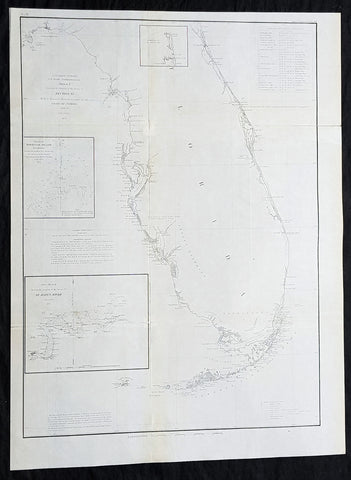
1855 A D Bache Large Rare Antique Map of Florida - US Coast Survey
- Title : US Coast Survey A D Bache Super. Sketch F Showing the Progress of the Survey in Section VI 1848-55...1855.
- Size: 25in x 18 1/2in (635mm x 470mm)
- Condition: (A+) Fine Condition
- Date : 1855
- Ref #: 93022
Description:
This large, rare, original antique lithograph early map of Florida and the progress of the surveys since 1848 by Alexander Dallas Bache (great-grandson of Benjamin Franklin) in 1855 - dated - was published by the official chart-maker of the United States, the office of The US Coast Survey.
The Office of the Coast Survey, founded in 1807 by President Thomas Jefferson and Secretary of Commerce Albert Gallatin, is the oldest scientific organization in the U.S. Federal Government. Jefferson created the Survey of the Coast, as it was then called, in response to a need for accurate navigational charts of the new nation\'s coasts and harbors.
General Definitions:
Paper thickness and quality: - Heavy and stable
Paper color : - off white
Age of map color: -
Colors used: -
General color appearance: -
Paper size: - 25in x 18 1/2in (635mm x 470mm)
Plate size: - 25in x 18 1/2in (635mm x 470mm)
Margins: - Min 1/2in (12mm)
Imperfections:
Margins: - None
Plate area: - Folds as issued
Verso: - Some folds re-enforced with archival tape
Background:
Florida was the first region of the continental United States to be visited and settled by Europeans. The earliest known European explorers came with the Spanish conquistador Juan Ponce de León. Ponce de León spotted and landed on the peninsula on April 2, 1513. He named the region Florida (land of flowers) The story that he was searching for the Fountain of Youth is mythical and only appeared long after his death.
In May 1539, Conquistador Hernando de Soto skirted the coast of Florida, searching for a deep harbor to land. He described seeing a thick wall of red mangroves spread mile after mile, some reaching as high as 70 feet (21 m), with intertwined and elevated roots making landing difficult. The Spanish introduced Christianity, cattle, horses, sheep, the Castilian language, and more to Florida. Spain established several settlements in Florida, with varying degrees of success. In 1559, Don Tristán de Luna y Arellano established a settlement at present-day Pensacola, making it the first attempted settlement in Florida, but it was mostly abandoned by 1561.
In 1565, the settlement of St. Augustine (San Agustín) was established under the leadership of admiral and governor Pedro Menéndez de Avilés, creating what would become one of the oldest, continuously-occupied European settlements in the continental U.S. and establishing the first generation of Floridanos and the Government of Florida. Spain maintained strategic control over the region by converting the local tribes to Christianity. The marriage between Luisa de Abrego, a free black domestic servant from Seville, and Miguel Rodríguez, a white Segovian, occurred in 1565 in St. Augustine. It is the first recorded Christian marriage in the continental United States.
Some Spanish married or had unions with Pensacola, Creek or African women, both slave and free, and their descendants created a mixed-race population of mestizos and mulattos. The Spanish encouraged slaves from the southern British colonies to come to Florida as a refuge, promising freedom in exchange for conversion to Catholicism. King Charles II of Spain issued a royal proclamation freeing all slaves who fled to Spanish Florida and accepted conversion and baptism. Most went to the area around St. Augustine, but escaped slaves also reached Pensacola. St. Augustine had mustered an all-black militia unit defending Spain as early as 1683.
The geographical area of Florida diminished with the establishment of English settlements to the north and French claims to the west. The English attacked St. Augustine, burning the city and its cathedral to the ground several times. Spain built the Castillo de San Marcos in 1672 and Fort Matanzas in 1742 to defend Floridas capital city from attacks, and to maintain its strategic position in the defense of the Captaincy General of Cuba and the Spanish West Indies.
Florida attracted numerous Africans and African Americans from adjacent British colonies who sought freedom from slavery. In 1738, Governor Manuel de Montiano established Fort Gracia Real de Santa Teresa de Mose near St. Augustine, a fortified town for escaped slaves to whom Montiano granted citizenship and freedom in return for their service in the Florida militia, and which became the first free black settlement legally sanctioned in North America.
In 1763, Spain traded Florida to the Kingdom of Great Britain for control of Havana, Cuba, which had been captured by the British during the Seven Years War. It was part of a large expansion of British territory following their victory in the Seven Years War. A large portion of the Floridano population left, taking along most of the remaining indigenous population to Cuba. The British soon constructed the Kings Road connecting St. Augustine to Georgia. The road crossed the St. Johns River at a narrow point called Wacca Pilatka, or the British name Cow Ford, ostensibly reflecting the fact that cattle were brought across the river there.
The British divided and consolidated the Florida provinces (Las Floridas) into East Florida and West Florida, a division the Spanish government kept after the brief British period. The British government gave land grants to officers and soldiers who had fought in the French and Indian War in order to encourage settlement. In order to induce settlers to move to Florida, reports of its natural wealth were published in England. A large number of British settlers who were described as being energetic and of good character moved to Florida, mostly coming from South Carolina, Georgia and England. There was also a group of settlers who came from the colony of Bermuda. This would be the first permanent English-speaking population in what is now Duval County, Baker County, St. Johns County and Nassau County. The British built good public roads and introduced the cultivation of sugar cane, indigo and fruits as well as the export of lumber.
The British governors were directed to call general assemblies as soon as possible in order to make laws for the Floridas, and in the meantime they were, with the advice of councils, to establish courts. This was the first introduction of the English-derived legal system which Florida still has today, including trial by jury, habeas corpus and county-based government. Neither East Florida nor West Florida sent any representatives to Philadelphia to draft the Declaration of Independence. Florida remained a Loyalist stronghold for the duration of the American Revolution.
Spain regained both East and West Florida after Britains defeat in the American Revolution and the subsequent Treaty of Versailles in 1783, and continued the provincial divisions until 1821.
Defense of Floridas northern border with the United States was minor during the second Spanish period. The region became a haven for escaped slaves and a base for Indian attacks against U.S. territories, and the U.S. pressed Spain for reform.
Americans of English descent and Americans of Scots-Irish descent began moving into northern Florida from the backwoods of Georgia and South Carolina. Though technically not allowed by the Spanish authorities and the Floridan government, they were never able to effectively police the border region and the backwoods settlers from the United States would continue to immigrate into Florida unchecked. These migrants, mixing with the already present British settlers who had remained in Florida since the British period, would be the progenitors of the population known as Florida Crackers.
These American settlers established a permanent foothold in the area and ignored Spanish authorities. The British settlers who had remained also resented Spanish rule, leading to a rebellion in 1810 and the establishment for ninety days of the so-called Free and Independent Republic of West Florida on September 23. After meetings beginning in June, rebels overcame the garrison at Baton Rouge (now in Louisiana), and unfurled the flag of the new republic: a single white star on a blue field. This flag would later become known as the Bonnie Blue Flag.
In 1810, parts of West Florida were annexed by proclamation of President James Madison, who claimed the region as part of the Louisiana Purchase. These parts were incorporated into the newly formed Territory of Orleans. The U.S. annexed the Mobile District of West Florida to the Mississippi Territory in 1812. Spain continued to dispute the area, though the United States gradually increased the area it occupied. In 1812, a group of settlers from Georgia, with de facto support from the U.S. federal government, attempted to overthrow the Floridan government in the province of East Florida. The settlers hoped to convince Floridans to join their cause and proclaim independence from Spain, but the settlers lost their tenuous support from the federal government and abandoned their cause by 1813.
Seminoles based in East Florida began raiding Georgia settlements, and offering havens for runaway slaves. The United States Army led increasingly frequent incursions into Spanish territory, including the 1817–1818 campaign against the Seminole Indians by Andrew Jackson that became known as the First Seminole War. The United States now effectively controlled East Florida. Control was necessary according to Secretary of State John Quincy Adams because Florida had become a derelict open to the occupancy of every enemy, civilized or savage, of the United States, and serving no other earthly purpose than as a post of annoyance to them.
Florida had become a burden to Spain, which could not afford to send settlers or garrisons. Madrid therefore decided to cede the territory to the United States through the Adams–Onís Treaty, which took effect in 1821. President James Monroe was authorized on March 3, 1821 to take possession of East Florida and West Florida for the United States and provide for initial governance. Andrew Jackson, on behalf of the U.S. federal government, served as a military commissioner with the powers of governor of the newly acquired territory for a brief period. On March 30, 1822, the U.S. Congress merged East Florida and part of West Florida into the Florida Territory.
By the early 1800s, Indian removal was a significant issue throughout the southeastern U.S. and also in Florida. In 1830, the U.S. Congress passed the Indian Removal Act and as settlement increased, pressure grew on the U.S. government to remove the Indians from Florida. Seminoles offered sanctuary to blacks, and these became known as the Black Seminoles, and clashes between whites and Indians grew with the influx of new settlers. In 1832, the Treaty of Paynes Landing promised to the Seminoles lands west of the Mississippi River if they agreed to leave Florida. Many Seminole left at this time.
Some Seminoles remained, and the U.S. Army arrived in Florida, leading to the Second Seminole War (1835–1842). Following the war, approximately 3,000 Seminole and 800 Black Seminole were removed to Indian Territory. A few hundred Seminole remained in Florida in the Everglades.
On March 3, 1845, only one day before the end of President John Tylers term in office, Florida became the 27th state to join the United States of America. The state was admitted as a slave state and ceased to be a sanctuary for runaway slaves. Initially its population grew slowly.
As European settlers continued to encroach on Seminole lands, and the United States intervened to move the remaining Seminoles to the West. The Third Seminole War (1855–58) resulted in the forced removal of most of the remaining Seminoles, although hundreds of Seminole Indians remained in the Everglades
American settlers began to establish cotton plantations in north Florida, which required numerous laborers, which they supplied by buying slaves in the domestic market. By 1860, Florida had only 140,424 people, of whom 44% were enslaved. There were fewer than 1,000 free African Americans before the American Civil War.
On January 10, 1861, nearly all delegates in the Florida Legislature approved an ordinance of secession, declaring Florida to be a sovereign and independent nation—an apparent reassertion to the preamble in Floridas Constitution of 1838, in which Florida agreed with Congress to be a Free and Independent State. Although not directly related to the issue of slavery, the ordinance declared Floridas secession from the Union, allowing it to become one of the founding members of the Confederate States, a looser union of states.
The Confederacy received little help from Florida; the 15,000 men it offered were generally sent elsewhere. Instead of men and manufactured goods, Florida did provide salt and, more importantly, beef to feed the Confederate armies. This was particularly important after 1864, when the Confederacy lost control of the Mississippi River, thereby losing access to Texas beef. The largest engagements in the state were the Battle of Olustee, on February 20, 1864, and the Battle of Natural Bridge, on March 6, 1865. Both were Confederate victories. The war ended in 1865.
Following the American Civil War, Floridas congressional representation was restored on June 25, 1868, albeit forcefully after Radical Reconstruction and the installation of unelected government officials under the final authority of federal military commanders. After the Reconstruction period ended in 1876, white Democrats regained power in the state legislature. In 1885, they created a new constitution, followed by statutes through 1889 that disfranchised most blacks and many poor whites.
Until the mid-20th century, Florida was the least populous state in the southern United States. In 1900, its population was only 528,542, of whom nearly 44% were African American, the same proportion as before the Civil War. The boll weevil devastated cotton crops.
Forty thousand blacks, roughly one-fifth of their 1900 population, left the state in the Great Migration. They left due to lynchings and racial violence, and for better opportunities. Disfranchisement for most African Americans in the state persisted until the Civil Rights Movement of the 1960s gained federal legislation in 1965 to enforce protection of their constitutional suffrage.
U.S. Coast Survey (Office of Coast Survey)
The Office of Coast Survey is the official chart-maker of the United States. Set up in 1807, it is one of the U.S. governments oldest scientific organizations. In 1878 it was given the name of Coast and Geodetic Survey (C&GS). In 1970 it became part of the National Oceanic and Atmospheric Administration (NOAA).
The agency was established in 1807 when President Thomas Jefferson signed the document entitled An act to provide for surveying the coasts of the United States. While the bills objective was specific—to produce nautical charts—it reflected larger issues of concern to the new nation: national boundaries, commerce, and defence.
The early years were difficult. Ferdinand Rudolph Hassler, who was eventually to become the agencys first superintendent, went to England to collect scientific instruments but was unable to return through the duration of the War of 1812. After his return, he worked on a survey of the New York Harbor in 1817, but Congress stepped in to suspend the work because of tensions between civilian and military control of the agency. After several years under the control of the U.S. Army, the Survey of the Coast was reestablished in 1832, and President Andrew Jackson appointed Hassler as superintendent.
The U.S. Coast Survey was a civilian agency but, from the beginning, members of the Navy and Army were detailed to service with the Survey, and Navy ships were also detailed to its use. In general, army officers worked on topographic surveys on the land and maps based on the surveys, while navy officers worked on hydrographic surveys in coastal waters.
Alexander Dallas Bache, great-grandson of Benjamin Franklin, was the second Coast Survey superintendent. Bache was a physicist, scientist, and surveyor who established the first magnetic observatory and served as the first president of the National Academy of Sciences. Under Bache, Coast Survey quickly applied its resources to the Union cause during the Civil War. In addition to setting up additional lithographic presses to produce the thousands of charts required by the Navy and other vessels, Bache made a critical decision to send Coast Survey parties to work with blockading squadrons and armies in the field, producing hundreds of maps and charts. Bache detailed these activities in his annual reports to Congress.
Coast Survey cartographer Edwin Hergesheimer created the map showing the density of the slave population in the Southern states.
Bache was also one of four members of the governments Blockade Strategy Board, planning strategy to essentially strangle the South, economically and militarily. On April 16, 1861, President Lincoln issued a proclamation declaring the blockade of ports from South Carolina to Texas. Baches Notes on the Coast provided valuable information for Union naval forces.
Maps were of paramount importance in wartime:
It is certain that accurate maps must form the basis of well-conducted military operations, and that the best time to procure them is not when an attack is impending, or when the army waits, but when there is no hindrance to, or pressure upon, the surveyors. That no coast can be effectively attacked, defended, or blockaded without accurate maps and charts, has been fully proved by the events of the last two years, if, indeed, such a proposition required practical proof.
— Alexander Dallas Bache, 1862 report.
Coast Survey attracted some of the best and brightest scientists and naturalists. It commissioned the naturalist Louis Agassiz to conduct the first scientific study of the Florida reef system. James McNeill Whistler, who went on to paint the iconic Whistlers Mother, was a Coast Survey engraver. The naturalist John Muir was a guide and artist on Survey of the 39th Parallel across the Great Basin of Nevada and Utah.
The agencys men and women (women professionals were hired as early as 1845) led scientific and engineering activities through the decades. In 1926, they started production of aeronautical charts. During the height of the Great Depression, Coast and Geodetic Survey organized surveying parties and field offices that employed over 10,000 people, including many out-of-work engineers.
In World War II, C&GS sent over 1,000 civilian members and more than half of its commissioned officers to serve as hydrographers, artillery surveyors, cartographers, army engineers, intelligence officers, and geophysicists in all theaters of the war. Civilians on the home front produced over 100 million maps and charts for the Allied Forces. Eleven members of the C&GS gave their lives during the war.
Alexander Dallas Bache 1806 – 1867 was an American physicist, scientist, and surveyor who erected coastal fortifications and conducted a detailed survey to map the mid-eastern United States coastline. Originally an army engineer, he later became Superintendent of the U.S. Coast Survey, and built it into the foremost scientific institution in the country before the Civil War.
Alexander Bache was born in Philadelphia, the son of Richard Bache, Jr., and Sophia Burrell Dallas Bache. He came from a prominent family as he was the nephew of Vice-President George M. Dallas and naval hero Alexander J. Dallas. He was the grandson of Secretary of the Treasury Alexander Dallas and was the great-grandson of Benjamin Franklin.
Bache was a professor of natural philosophy and chemistry at the University of Pennsylvania from 1828 to 1841 and again from 1842 to 1843. He spent 1836–1838 in Europe on behalf of the trustees of what became Girard College; he was named president of the college after his return. Abroad, he examined European education systems, and on his return he published a valuable report. From 1839 to 1842, he served as the first president of Central High School of Philadelphia, one of the oldest public high schools in the United States.
In 1843, on the death of Professor Ferdinand Rudolph Hassler, Bache was appointed superintendent of the United States Coast Survey. He convinced the United States Congress of the value of this work and, by means of the liberal aid it granted, he completed the mapping of the whole coast by a skillful division of labor and the erection of numerous observing stations. In addition, magnetic and meteorological data were collected. Bache served as head of the Coast Survey for 24 years (until his death).
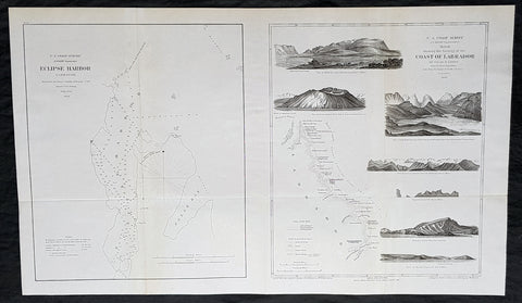
1860 US Coast Survey & A D Bache Rare Antique Geological Map of the Coast of Labrador NFL Canada
- Title : US Coast Survey A D Bache Superintendant Sketch Showing the Geology of the Coast of Labrador....1860
- Size: 28 1/2in x 17in (725mm x 430mm)
- Condition: (A+) Fine Condition
- Date : 1860
- Ref #: 93039
Description:
This large, rare, original antique lithograph early map of the geology of the Western coastline of the Labrador Coast, Canada - from the St Lawrence River mouth north to Cape Chidley - with a map of Eclipse Bay, by Alexander Dallas Bache (great-grandson of Benjamin Franklin) in 1860 - dated - was published by the official chart-maker of the United States, the office of The US Coast Survey.
The Office of the Coast Survey, founded in 1807 by President Thomas Jefferson and Secretary of Commerce Albert Gallatin, is the oldest scientific organization in the U.S. Federal Government. Jefferson created the Survey of the Coast, as it was then called, in response to a need for accurate navigational charts of the new nation\'s coasts and harbors.
General Definitions:
Paper thickness and quality: - Heavy and stable
Paper color : - off white
Age of map color: -
Colors used: -
General color appearance: -
Paper size: - 28 1/2in x 17in (725mm x 430mm)
Plate size: - 28 1/2in x 17in (725mm x 430mm)
Margins: - Min 1/2in (12mm)
Imperfections:
Margins: - None
Plate area: - None
Verso: - None
Background:
This is a beautiful 1860 map or chart showing the geology along the coast of Labrador in the Canadian province of Newfoundland and Labrador issued by the U.S. Coast Survey. The chart shows the distribution of the different types of rocks or geological formations of the region, extending from the Gulf of St. Lawrence northward to Cape Chidley and Ungava Bay. Perhaps the most interesting feature of this chart is the series of coastal views including View of Mt. Bache, Aulezavik Island, View of the Crater shaped Mt. E Side of Aulezavik Island, View of high peaks between Aulezavik Sound and Ungava Bay, View of Coast of Labrador, Mugford Island, Entrance to Port Manvers, and View of Battle Island.
The map was drawn from original sketches of Oscar Montgomery Lieber, who accompanied the American astronomical expedition to Labrador as geologist. This map was created under the direction of A. D. Bache, Superintendent of the Survey of the Coast of the United States and one of the most influential American cartographers of the 19th century. Issued for the 1860 Superintendents Report.
U.S. Coast Survey (Office of Coast Survey)
The Office of Coast Survey is the official chart-maker of the United States. Set up in 1807, it is one of the U.S. governments oldest scientific organizations. In 1878 it was given the name of Coast and Geodetic Survey (C&GS). In 1970 it became part of the National Oceanic and Atmospheric Administration (NOAA).
The agency was established in 1807 when President Thomas Jefferson signed the document entitled An act to provide for surveying the coasts of the United States. While the bills objective was specific—to produce nautical charts—it reflected larger issues of concern to the new nation: national boundaries, commerce, and defence.
The early years were difficult. Ferdinand Rudolph Hassler, who was eventually to become the agencys first superintendent, went to England to collect scientific instruments but was unable to return through the duration of the War of 1812. After his return, he worked on a survey of the New York Harbor in 1817, but Congress stepped in to suspend the work because of tensions between civilian and military control of the agency. After several years under the control of the U.S. Army, the Survey of the Coast was reestablished in 1832, and President Andrew Jackson appointed Hassler as superintendent.
The U.S. Coast Survey was a civilian agency but, from the beginning, members of the Navy and Army were detailed to service with the Survey, and Navy ships were also detailed to its use. In general, army officers worked on topographic surveys on the land and maps based on the surveys, while navy officers worked on hydrographic surveys in coastal waters.
Alexander Dallas Bache, great-grandson of Benjamin Franklin, was the second Coast Survey superintendent. Bache was a physicist, scientist, and surveyor who established the first magnetic observatory and served as the first president of the National Academy of Sciences. Under Bache, Coast Survey quickly applied its resources to the Union cause during the Civil War. In addition to setting up additional lithographic presses to produce the thousands of charts required by the Navy and other vessels, Bache made a critical decision to send Coast Survey parties to work with blockading squadrons and armies in the field, producing hundreds of maps and charts. Bache detailed these activities in his annual reports to Congress.
Coast Survey cartographer Edwin Hergesheimer created the map showing the density of the slave population in the Southern states.
Bache was also one of four members of the governments Blockade Strategy Board, planning strategy to essentially strangle the South, economically and militarily. On April 16, 1861, President Lincoln issued a proclamation declaring the blockade of ports from South Carolina to Texas. Baches Notes on the Coast provided valuable information for Union naval forces.
Maps were of paramount importance in wartime:
It is certain that accurate maps must form the basis of well-conducted military operations, and that the best time to procure them is not when an attack is impending, or when the army waits, but when there is no hindrance to, or pressure upon, the surveyors. That no coast can be effectively attacked, defended, or blockaded without accurate maps and charts, has been fully proved by the events of the last two years, if, indeed, such a proposition required practical proof.
— Alexander Dallas Bache, 1862 report.
Coast Survey attracted some of the best and brightest scientists and naturalists. It commissioned the naturalist Louis Agassiz to conduct the first scientific study of the Florida reef system. James McNeill Whistler, who went on to paint the iconic Whistlers Mother, was a Coast Survey engraver. The naturalist John Muir was a guide and artist on Survey of the 39th Parallel across the Great Basin of Nevada and Utah.
The agencys men and women (women professionals were hired as early as 1845) led scientific and engineering activities through the decades. In 1926, they started production of aeronautical charts. During the height of the Great Depression, Coast and Geodetic Survey organized surveying parties and field offices that employed over 10,000 people, including many out-of-work engineers.
In World War II, C&GS sent over 1,000 civilian members and more than half of its commissioned officers to serve as hydrographers, artillery surveyors, cartographers, army engineers, intelligence officers, and geophysicists in all theaters of the war. Civilians on the home front produced over 100 million maps and charts for the Allied Forces. Eleven members of the C&GS gave their lives during the war.
Alexander Dallas Bache 1806 – 1867 was an American physicist, scientist, and surveyor who erected coastal fortifications and conducted a detailed survey to map the mid-eastern United States coastline. Originally an army engineer, he later became Superintendent of the U.S. Coast Survey, and built it into the foremost scientific institution in the country before the Civil War.
Alexander Bache was born in Philadelphia, the son of Richard Bache, Jr., and Sophia Burrell Dallas Bache. He came from a prominent family as he was the nephew of Vice-President George M. Dallas and naval hero Alexander J. Dallas. He was the grandson of Secretary of the Treasury Alexander Dallas and was the great-grandson of Benjamin Franklin.
Bache was a professor of natural philosophy and chemistry at the University of Pennsylvania from 1828 to 1841 and again from 1842 to 1843. He spent 1836–1838 in Europe on behalf of the trustees of what became Girard College; he was named president of the college after his return. Abroad, he examined European education systems, and on his return he published a valuable report. From 1839 to 1842, he served as the first president of Central High School of Philadelphia, one of the oldest public high schools in the United States.
In 1843, on the death of Professor Ferdinand Rudolph Hassler, Bache was appointed superintendent of the United States Coast Survey. He convinced the United States Congress of the value of this work and, by means of the liberal aid it granted, he completed the mapping of the whole coast by a skillful division of labor and the erection of numerous observing stations. In addition, magnetic and meteorological data were collected. Bache served as head of the Coast Survey for 24 years (until his death).
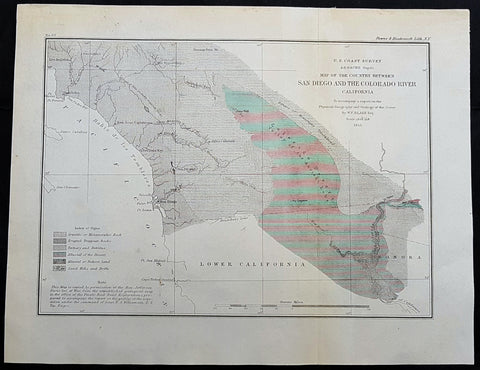
1855 US Coast Survey & A D Bache Antique Map Lower Colorado River Valley & San Diego, California
- Title : US Coast Survey A D Bache Superintendant Map of the Vicinity of Monterey Bay California...By W P Blake esq. 1855
- Size: 12in x 9in (305mm x 230mm)
- Condition: (A+) Fine Condition
- Date : 1855
- Ref #: 93018
This original antique lithograph map of the lower Colorado River Valley and San Diego, by Alexander Dallas Bache (great-grandson of Benjamin Franklin) in 1855 - dated - was published by the official chart-maker of the United States, the office of The US Coast Survey.
General Definitions:
Paper thickness and quality: - Heavy and stable
Paper color : - off white
Age of map color: -
Colors used: -
General color appearance: -
Paper size: - 12in x 9in (305mm x 230mm)
Plate size: - 12in x 9in (305mm x 230mm)
Margins: - Min 1/2in (12mm)
Imperfections:
Margins: - None
Plate area: - None
Verso: - None
Background:
The Colorado River is a major river of the western United States and northwest Mexico in North America. Its headwaters are in the Rocky Mountains where La Poudre Pass Lake is its source. Located in north central Colorado it flows southwest through the Colorado Plateau country of western Colorado, southeastern Utah and northwestern Arizona where it flows through the Grand Canyon. It turns south near Las Vegas, Nevada, forming the Arizona–Nevada border in Lake Mead and the Arizona–California border a few miles below Davis Dam between Laughlin, Nevada and Needles, California California before entering Mexico in the Colorado Desert. Most of its waters are diverted into the Imperial Valley of Southern California. In Mexico its course forms the boundary between Sonora and Baja California before entering the Gulf of California.
The Colorado forms the border of California to the west and Arizona to the east for most of its course through the desert Lower Colorado River Valley (LCRV), where its character changes significantly from fast-flowing whitewater to a low gradient braided stream with a wide floodplain. Here, the Colorado River ranges in width from 700 to 2,500 ft (200 to 800 m) and from 8 to 100 ft (2 to 30 m) in depth. It becomes a losing stream, with a gradual reduction in volume both due to evaporation in the hot desert climate and massive diversions for irrigation, urban areas, industry and thermo-electric power generation. The average flow rate of 14,180 cubic feet per second (402 m3/s) at Davis Dam diminishes to just 2,060 cubic feet per second (58 m3/s) at the Mexican border.
At Needles, California the Colorado is crossed by Interstate 40; shortly downstream it passes the Topock Marsh in Topock Gorge and widens into Lake Havasu, formed by Parker Dam. Lake Havasu provides recreation as well as the home of the retired U.K. London Bridge in Lake Havasu City, Arizona, now the New London Bridge. Near Parker Dam are the first two major diversions of the lower Colorado: the Colorado River Aqueduct, which travels 240 miles (390 km) west to Los Angeles and San Diego, California; and the Central Arizona Project, which sends water 340 miles (550 km) east towards Phoenix and Tucson, Arizona. The intermittent Bill Williams River joins the Colorado from the east in Lake Havasu, just above Parker Dam.
U.S. Coast Survey (Office of Coast Survey)
The Office of Coast Survey is the official chart-maker of the United States. Set up in 1807, it is one of the U.S. governments oldest scientific organizations. In 1878 it was given the name of Coast and Geodetic Survey (C&GS). In 1970 it became part of the National Oceanic and Atmospheric Administration (NOAA).
The agency was established in 1807 when President Thomas Jefferson signed the document entitled An act to provide for surveying the coasts of the United States. While the bills objective was specific—to produce nautical charts—it reflected larger issues of concern to the new nation: national boundaries, commerce, and defence.
The early years were difficult. Ferdinand Rudolph Hassler, who was eventually to become the agencys first superintendent, went to England to collect scientific instruments but was unable to return through the duration of the War of 1812. After his return, he worked on a survey of the New York Harbor in 1817, but Congress stepped in to suspend the work because of tensions between civilian and military control of the agency. After several years under the control of the U.S. Army, the Survey of the Coast was reestablished in 1832, and President Andrew Jackson appointed Hassler as superintendent.
The U.S. Coast Survey was a civilian agency but, from the beginning, members of the Navy and Army were detailed to service with the Survey, and Navy ships were also detailed to its use. In general, army officers worked on topographic surveys on the land and maps based on the surveys, while navy officers worked on hydrographic surveys in coastal waters.
Alexander Dallas Bache, great-grandson of Benjamin Franklin, was the second Coast Survey superintendent. Bache was a physicist, scientist, and surveyor who established the first magnetic observatory and served as the first president of the National Academy of Sciences. Under Bache, Coast Survey quickly applied its resources to the Union cause during the Civil War. In addition to setting up additional lithographic presses to produce the thousands of charts required by the Navy and other vessels, Bache made a critical decision to send Coast Survey parties to work with blockading squadrons and armies in the field, producing hundreds of maps and charts. Bache detailed these activities in his annual reports to Congress.
Coast Survey cartographer Edwin Hergesheimer created the map showing the density of the slave population in the Southern states.
Bache was also one of four members of the governments Blockade Strategy Board, planning strategy to essentially strangle the South, economically and militarily. On April 16, 1861, President Lincoln issued a proclamation declaring the blockade of ports from South Carolina to Texas. Baches Notes on the Coast provided valuable information for Union naval forces.
Maps were of paramount importance in wartime:
It is certain that accurate maps must form the basis of well-conducted military operations, and that the best time to procure them is not when an attack is impending, or when the army waits, but when there is no hindrance to, or pressure upon, the surveyors. That no coast can be effectively attacked, defended, or blockaded without accurate maps and charts, has been fully proved by the events of the last two years, if, indeed, such a proposition required practical proof.
— Alexander Dallas Bache, 1862 report.
Coast Survey attracted some of the best and brightest scientists and naturalists. It commissioned the naturalist Louis Agassiz to conduct the first scientific study of the Florida reef system. James McNeill Whistler, who went on to paint the iconic Whistlers Mother, was a Coast Survey engraver. The naturalist John Muir was a guide and artist on Survey of the 39th Parallel across the Great Basin of Nevada and Utah.
The agencys men and women (women professionals were hired as early as 1845) led scientific and engineering activities through the decades. In 1926, they started production of aeronautical charts. During the height of the Great Depression, Coast and Geodetic Survey organized surveying parties and field offices that employed over 10,000 people, including many out-of-work engineers.
In World War II, C&GS sent over 1,000 civilian members and more than half of its commissioned officers to serve as hydrographers, artillery surveyors, cartographers, army engineers, intelligence officers, and geophysicists in all theaters of the war. Civilians on the home front produced over 100 million maps and charts for the Allied Forces. Eleven members of the C&GS gave their lives during the war.
Alexander Dallas Bache 1806 – 1867 was an American physicist, scientist, and surveyor who erected coastal fortifications and conducted a detailed survey to map the mid-eastern United States coastline. Originally an army engineer, he later became Superintendent of the U.S. Coast Survey, and built it into the foremost scientific institution in the country before the Civil War.
Alexander Bache was born in Philadelphia, the son of Richard Bache, Jr., and Sophia Burrell Dallas Bache. He came from a prominent family as he was the nephew of Vice-President George M. Dallas and naval hero Alexander J. Dallas. He was the grandson of Secretary of the Treasury Alexander Dallas and was the great-grandson of Benjamin Franklin.
Bache was a professor of natural philosophy and chemistry at the University of Pennsylvania from 1828 to 1841 and again from 1842 to 1843. He spent 1836–1838 in Europe on behalf of the trustees of what became Girard College; he was named president of the college after his return. Abroad, he examined European education systems, and on his return he published a valuable report. From 1839 to 1842, he served as the first president of Central High School of Philadelphia, one of the oldest public high schools in the United States.
In 1843, on the death of Professor Ferdinand Rudolph Hassler, Bache was appointed superintendent of the United States Coast Survey. He convinced the United States Congress of the value of this work and, by means of the liberal aid it granted, he completed the mapping of the whole coast by a skillful division of labor and the erection of numerous observing stations. In addition, magnetic and meteorological data were collected. Bache served as head of the Coast Survey for 24 years (until his death).
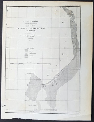
1855 US Coast Survey & A D Bache Antique Map of Monterey Bay, California
- Title : US Coast Survey A D Bache Superintendant Map of the Vicinity of Monterey Bay California...By W P Blake esq. 1855
- Size: 11 1/2in x 9in (290mm x 230mm)
- Condition: (A+) Fine Condition
- Date : 1855
- Ref #: 93017
Description:
This original antique lithograph map of Monterey Bay, California by Alexander Dallas Bache (great-grandson of Benjamin Franklin) in 1855 - dated - was published by the official chart-maker of the United Stetes, the office of The US Coast Survey.
Alexander Dallas Bache 1806 – 1867 was an American physicist, scientist, and surveyor who erected coastal fortifications and conducted a detailed survey to map the mid-eastern United States coastline. Originally an army engineer, he later became Superintendent of the U.S. Coast Survey, and built it into the foremost scientific institution in the country before the Civil War.
Alexander Bache was born in Philadelphia, the son of Richard Bache, Jr., and Sophia Burrell Dallas Bache. He came from a prominent family as he was the nephew of Vice-President George M. Dallas and naval hero Alexander J. Dallas. He was the grandson of Secretary of the Treasury Alexander Dallas and was the great-grandson of Benjamin Franklin.
Bache was a professor of natural philosophy and chemistry at the University of Pennsylvania from 1828 to 1841 and again from 1842 to 1843. He spent 1836–1838 in Europe on behalf of the trustees of what became Girard College; he was named president of the college after his return. Abroad, he examined European education systems, and on his return he published a valuable report. From 1839 to 1842, he served as the first president of Central High School of Philadelphia, one of the oldest public high schools in the United States.
In 1843, on the death of Professor Ferdinand Rudolph Hassler, Bache was appointed superintendent of the United States Coast Survey. He convinced the United States Congress of the value of this work and, by means of the liberal aid it granted, he completed the mapping of the whole coast by a skillful division of labor and the erection of numerous observing stations. In addition, magnetic and meteorological data were collected. Bache served as head of the Coast Survey for 24 years (until his death).
General Definitions:
Paper thickness and quality: - Heavy and stable
Paper color : - off white
Age of map color: -
Colors used: -
General color appearance: -
Paper size: - 11 1/2in x 9in (290mm x 230mm)
Plate size: - 11 1/2in x 9in (290mm x 230mm)
Margins: - Min 1/2in (12mm)
Imperfections:
Margins: - Light age toning
Plate area: - None
Verso: - None
Background:
The earliest archaeological evidence of human habitation of the territory of the city of San Francisco dates to 3000 BC. The Yelamu group of the Ohlone people resided in a few small villages when an overland Spanish exploration party, led by Don Gaspar de Portolà, arrived on November 2, 1769, the first documented European visit to San Francisco Bay. Seven years later, on March 28, 1776, the Spanish established the Presidio of San Francisco, followed by a mission, Mission San Francisco de Asís (Mission Dolores), established by the Spanish explorer Juan Bautista de Anza.
Upon independence from Spain in 1821, the area became part of Mexico. Under Mexican rule, the mission system gradually ended, and its lands became privatized. In 1835, Englishman William Richardson erected the first independent homestead, near a boat anchorage around what is today Portsmouth Square. Together with Alcalde Francisco de Haro, he laid out a street plan for the expanded settlement, and the town, named Yerba Buena, began to attract American settlers. Commodore John D. Sloat claimed California for the United States on July 7, 1846, during the Mexican–American War, and Captain John B. Montgomery arrived to claim Yerba Buena two days later. Yerba Buena was renamed San Francisco on January 30 of the next year, and Mexico officially ceded the territory to the United States at the end of the war. Despite its attractive location as a port and naval base, San Francisco was still a small settlement with inhospitable geography.
The California Gold Rush brought a flood of treasure seekers (known as forty-niners, as in 1849). With their sourdough bread in tow, prospectors accumulated in San Francisco over rival Benicia, raising the population from 1,000 in 1848 to 25,000 by December 1849. The promise of great wealth was so strong that crews on arriving vessels deserted and rushed off to the gold fields, leaving behind a forest of masts in San Francisco harbor. Some of these approximately 500 abandoned ships were used at times as storeships, saloons and hotels; many were left to rot and some were sunk to establish title to the underwater lot. By 1851 the harbor was extended out into the bay by wharves while buildings were erected on piles among the ships. By 1870 Yerba Buena Cove had been filled to create new land. Buried ships are occasionally exposed when foundations are dug for new buildings.
California was quickly granted statehood in 1850, and the U.S. military built Fort Point at the Golden Gate and a fort on Alcatraz Island to secure the San Francisco Bay. Silver discoveries, including the Comstock Lode in Nevada in 1859, further drove rapid population growth. With hordes of fortune seekers streaming through the city, lawlessness was common, and the Barbary Coast section of town gained notoriety as a haven for criminals, prostitution, and gambling.
Entrepreneurs sought to capitalize on the wealth generated by the Gold Rush. Early winners were the banking industry, with the founding of Wells Fargo in 1852 and the Bank of California in 1864. Development of the Port of San Francisco and the establishment in 1869 of overland access to the eastern U.S. rail system via the newly completed Pacific Railroad (the construction of which the city only reluctantly helped support) helped make the Bay Area a center for trade. Catering to the needs and tastes of the growing population, Levi Strauss opened a dry goods business and Domingo Ghirardelli began manufacturing chocolate. Immigrant laborers made the city a polyglot culture, with Chinese Railroad Workers, drawn to Old Gold Mountain, creating the citys Chinatown quarter. In 1870, Asians made up 8% of the population. The first cable cars carried San Franciscans up Clay Street in 1873. The citys sea of Victorian houses began to take shape, and civic leaders campaigned for a spacious public park, resulting in plans for Golden Gate Park. San Franciscans built schools, churches, theaters, and all the hallmarks of civic life. The Presidio developed into the most important American military installation on the Pacific coast. By 1890, San Franciscos population approached 300,000, making it the eighth-largest city in the United States at the time. Around 1901, San Francisco was a major city known for its flamboyant style, stately hotels, ostentatious mansions on Nob Hill, and a thriving arts scene. The first North American plague epidemic was the San Francisco plague of 1900–1904.
U.S. Coast Survey (Office of Coast Survey)
The Office of Coast Survey is the official chart-maker of the United States. Set up in 1807, it is one of the U.S. governments oldest scientific organizations. In 1878 it was given the name of Coast and Geodetic Survey (C&GS). In 1970 it became part of the National Oceanic and Atmospheric Administration (NOAA).
The agency was established in 1807 when President Thomas Jefferson signed the document entitled An act to provide for surveying the coasts of the United States. While the bills objective was specific—to produce nautical charts—it reflected larger issues of concern to the new nation: national boundaries, commerce, and defence.
The early years were difficult. Ferdinand Rudolph Hassler, who was eventually to become the agencys first superintendent, went to England to collect scientific instruments but was unable to return through the duration of the War of 1812. After his return, he worked on a survey of the New York Harbor in 1817, but Congress stepped in to suspend the work because of tensions between civilian and military control of the agency. After several years under the control of the U.S. Army, the Survey of the Coast was reestablished in 1832, and President Andrew Jackson appointed Hassler as superintendent.
The U.S. Coast Survey was a civilian agency but, from the beginning, members of the Navy and Army were detailed to service with the Survey, and Navy ships were also detailed to its use. In general, army officers worked on topographic surveys on the land and maps based on the surveys, while navy officers worked on hydrographic surveys in coastal waters.
Alexander Dallas Bache, great-grandson of Benjamin Franklin, was the second Coast Survey superintendent. Bache was a physicist, scientist, and surveyor who established the first magnetic observatory and served as the first president of the National Academy of Sciences. Under Bache, Coast Survey quickly applied its resources to the Union cause during the Civil War. In addition to setting up additional lithographic presses to produce the thousands of charts required by the Navy and other vessels, Bache made a critical decision to send Coast Survey parties to work with blockading squadrons and armies in the field, producing hundreds of maps and charts. Bache detailed these activities in his annual reports to Congress.
Coast Survey cartographer Edwin Hergesheimer created the map showing the density of the slave population in the Southern states.
Bache was also one of four members of the governments Blockade Strategy Board, planning strategy to essentially strangle the South, economically and militarily. On April 16, 1861, President Lincoln issued a proclamation declaring the blockade of ports from South Carolina to Texas. Baches Notes on the Coast provided valuable information for Union naval forces.
Maps were of paramount importance in wartime:
It is certain that accurate maps must form the basis of well-conducted military operations, and that the best time to procure them is not when an attack is impending, or when the army waits, but when there is no hindrance to, or pressure upon, the surveyors. That no coast can be effectively attacked, defended, or blockaded without accurate maps and charts, has been fully proved by the events of the last two years, if, indeed, such a proposition required practical proof.
— Alexander Dallas Bache, 1862 report.
Coast Survey attracted some of the best and brightest scientists and naturalists. It commissioned the naturalist Louis Agassiz to conduct the first scientific study of the Florida reef system. James McNeill Whistler, who went on to paint the iconic Whistlers Mother, was a Coast Survey engraver. The naturalist John Muir was a guide and artist on Survey of the 39th Parallel across the Great Basin of Nevada and Utah.
The agencys men and women (women professionals were hired as early as 1845) led scientific and engineering activities through the decades. In 1926, they started production of aeronautical charts. During the height of the Great Depression, Coast and Geodetic Survey organized surveying parties and field offices that employed over 10,000 people, including many out-of-work engineers.
In World War II, C&GS sent over 1,000 civilian members and more than half of its commissioned officers to serve as hydrographers, artillery surveyors, cartographers, army engineers, intelligence officers, and geophysicists in all theaters of the war. Civilians on the home front produced over 100 million maps and charts for the Allied Forces. Eleven members of the C&GS gave their lives during the war.
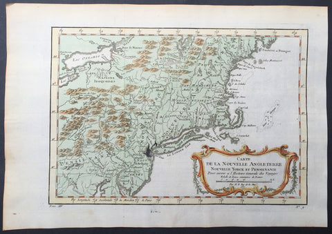
1757 Bellin Antique Map of New England, New York, New Jersey, Pennsylvania
- Title : Carte De La Nouvelle Angleterre...Par M B. 1757
- Ref #: 61097
- Size: 14 1/2in x 10in (370mm x 255mm)
- Date : 1757
- Condition: (A+) Fine Condition
Description:
This beautifully hand coloured original antique map of New England & the NE corridor of the US from Pennsylvania to Maine was engraved in 1757 - the date is engraved in the title - and was published in the 1757 French edition of Antoine-François Prevosts 20 volume L`Histoire Generale des Voyages published by Pierre de Hondt in the Hague between 1747 & 1785.
Antoine François Prévost d'Exiles 1697 - 1763, usually known simply as the Abbé Prévost, was a French author and novelist. (Ref: Tooley; M&B)
General Description:
Paper thickness and quality: - Heavy and stable
Paper color: - white
Age of map color: - Early
Colors used: - Green, yellow, red
General color appearance: - Authentic
Paper size: - 14 1/2in x 10in (370mm x 255mm)
Plate size: - 12 1/2in x 9in (320mm x 225mm)
Margins: - min. 1in (25mm)
Imperfections:
Margins: - None
Plate area: - Folds as issued, ink bleed from original plate
Verso: - None
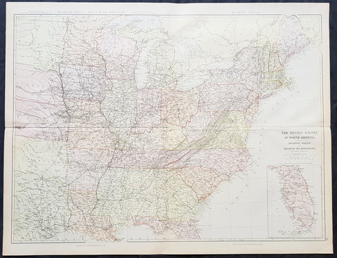
1860 Blackie & Son Large Antique Map of The Eastern United States, inset Florida
- Title : The United States of North America Atlantic States and Valley of the Mississippi
- Size: 28in x 22in (715mm x 560mm)
- Condition: (A+) Fine Condition
- Date : 1860
- Ref #: 80569
Description:
This 2 sheet joined original antique lithograph map of the eastern United States of America - west to the Mississippi Valley & Indian Territory - with and an inset map of Florida - was engraved by Edward Weller and published by Blackie & Son of Glasgow in the 1860 edition of Geographical Atlas. (Ref: Tooley; M&B)
General Definitions:
Paper thickness and quality: - Heavy and stable
Paper color : - off white
Age of map color: - Original
Colors used: - Yellow, green, blue, pink
General color appearance: - Authentic
Paper size: - 28in x 22in (715mm x 560mm)
Plate size: - 28in x 22in (715mm x 560mm)
Margins: - Min 1/2in (12mm)
Imperfections:
Margins: - None
Plate area: - None
Verso: - None
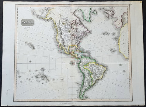
1817 John Thomson Large Antique Map of North & South America, Hawaiian Islands
- Title : America...Drawn & Engraved for Thomsons New General Atlas
- Date : 1817
- Size: 28in x 21 1/2in (710mm x 550mm)
- Condition: (A+) Fine Condition
- Ref: 35020
Description:
This large magnificent original hand coloured copper-plate engraved antique map of America drawn & engraved by John Thomson was published in the 1817 edition of Thomsons General Atlas
General Definitions:
Paper thickness and quality: - Heavy and stable
Paper color : - off white
Age of map color: - Original
Colors used: - Yellow, green, blue, pink
General color appearance: - Authentic
Paper size: - 28in x 21 1/2in (710mm x 550mm)
Plate size: - 25in x 20in (635mm x 510mm)
Margins: - Min 1in (25mm)
Imperfections:
Margins: - None
Plate area: - None
Verso: - None
Background:
The exploration of North America by non-indigenous people was a continuing effort to map and explore the continent of North America. It spanned centuries, and consisted of efforts by numerous people and expeditions from various foreign countries to map the continent. The European colonization of the Americas followed.
There were numerous Spanish explorers and conquistadors who explored the Southwest of North America (including present-day west and central United States) and cross the continent (east to west) in its southern regions, mainly from the second quarter to the middle of the 16th century, such as Álvar Núñez Cabeza de Vaca and Francisco Vásquez de Coronado, but also the North American Southeast and south-central regions, s Soto]].
In 1608 Samuel de Champlain founded what is now Quebec City, which would become the first permanent settlement and the capital of New France. He took personal administration over the city and its affairs, and sent out expeditions to explore the interior. Champlain himself discovered Lake Champlain in 1609. By 1615, he had travelled by canoe up the Ottawa River through Lake Nipissing and Georgian Bay to the centre of Huron country near Lake Simcoe. During these voyages, Champlain aided the Wendat (aka Hurons) in their battles against the Iroquois Confederacy. As a result, the Iroquois would become enemies of the French and be involved in multiple conflicts.
From 1679 to 1682 René-Robert Cavelier, Sieur de La Salle explored the Great Lakes region of the United States and Canada, and the entire course of Mississippi River to the Gulf of Mexico.
From 1697 to 1702 Eusebio Kino explored the Sonoran Desert and on his journey to the Colorado River Delta discovered an overland route to Baja California that was then commonly believed to be an island. In 1683 Kino lead the first European overland crossing of Baja California.
European exploration of western Canada was largely motivated by the fur trade and the search for the elusive Northwest Passage. Hudson\'s Bay Company explorer Henry Kelsey has the distinction of being the first European to see the northern Great Plains in 1690.
Anthony Henday was the first to have seen the Rocky Mountains, in 1754, but curiously did not mention it in his journals. From his westernmost geographic position (roughly near the town of Olds, Alberta, halfway between Calgary and Red Deer, Alberta) the Rockies should have been quite conspicuous, but he was likely trying to disguise the disappointing fact that an unknown range of seemingly impassible mountains now stood between the HBC and the Pacific. Samuel Hearne found the Coppermine River in 1769-71 in his failed search for copper ore deposits. Burned by these shortfalls, the HBC largely quit exploration.
The North West Company, on the other hand, used a business model that required constant expansion into untapped areas. Under the auspices of the NWC, Alexander Mackenzie discovered the Mackenzie River in 1789 and was the first European to reach the North-American Pacific overland, via the Bella Coola River, in 1793. Simon Fraser reached the Pacific in 1808 via the Fraser River.
David Thompson, widely regarded as the greatest land geographer that ever lived, traveled over 90,000 km during his lifetime. In 1797, Thompson was sent south by his employers to survey part of the Canada-U.S. boundary along the water routes from Lake Superior to Lake of the Woods to satisfy unresolved questions of territory arising from the Jay Treaty between Great Britain and the United States. By 1798 Thompson had completed a survey of 6,750 km (4,190 mi) from Grand Portage, through Lake Winnipeg, to the headwaters of the Assiniboine and Mississippi Rivers, as well as two sides of Lake Superior. In 1798, the company sent him to Red Deer Lake (in present-day Alberta) to establish a trading post. The English translation of Lac La Biche-Red Deer Lake-first appeared on the Mackenzie map of 1793. Thompson spent the next few seasons trading based in Fort George (now in Alberta), and during this time led several expeditions into the Rocky Mountains. In 1811/1812 he followed the Columbia River to the Pacific, and in 1814 used his notes and measurements to draft the first European-style map of western Canada, covering 3.9 million square kilometres.
Lewis and Clark were the first Americans to venture into the newly acquired territory of the Louisiana Purchase, at the order of President Thomas Jefferson. They discovered many new geographical features, Indian tribes, and animal and plant species. John Colter was a member of the expedition who subsequently became a guide for others in the Old West, and did some explorations of his own.
John C. Frémont led many important explorations in the Great Plains, Great Basin, Oregon territory, and Mexican Alta California.
Joseph Reddeford Walker was one of the most prominent of the explorers, and charted many new paths through the West, which often were then utilized by emigrants crossing to settle in Western towns and communities. In 1833, his exploring party discovered a route along the Humboldt River across present-day Nevada, ascending the Sierra Nevada following the Carson River and descending via Stanislaus River drainages to Monterey. His return route across the southern Sierra was via Walker Pass, named after Walker by John Charles Fremont. The approach of the Sierra via the Carson River route later became known as the California Trail, the primary route for the emigrants to the gold fields during the California gold rush.
As the American population of the West increased, the US government launched ongoing official explorations mainly through the US Army Corps of Topographical Engineers. One of the main officers and explorers in this unit was George Wheeler. In 1872, the US Congress authorized an ambitious plan to map the portion of the United States west of the 100th meridian at a scale of 8 miles to the inch. This plan necessitated what became known as the Wheeler Survey, along with the Clarence King and John Wesley Powell Surveys, and expeditions by Ferdinand Vandeveer Hayden. In 1879, all such efforts were reorganized as the United States Geological Survey.
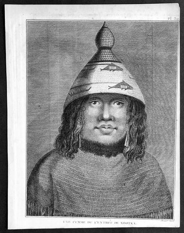
1785 Capt. Cook Antique Print Woman of Nootka Sound, Vancouver Isle Canada, 1778
- Title : Une Femme De L Entreee De Nootka
- Ref : 31768
- Size: 10in x 8in (255mm x 205mm)
- Date : 1785
- Condition: (A+) Fine Condition
Description:
This fine original copper-plate engraved antique print of a woman of Nootka Sound, on the West Coast of Vancouver Island, Canada, drawn during a visit by Captain Cook in 1778, during his 3rd and last Voyage of Discovery, was engraved by Robert Benard - after Cooks on-board artist, John Webber - and was published in the 1785 French edition of Capt. James Cook & Capt. James King A Voyage to the Pacific Ocean. Undertaken, by the Command of his Majesty, for making Discoveries in the Northern Hemisphere. To determine The Position and Extent of the West Side of North America; its Distance from Asia; and the Practicability of a Northen Passage to Europe. Performed under the direction of Captains Cook, Clerke, and Gore, In His Majesty\'s Ships the Resolution and Discovery. In the Years 1776, 1777, 1778, 1779, and 1780. In Three Volumes. Vol. I and II written by James Cook, F.R.S. Vol. III by Captain James King, LL.D. and F.R.S. Paris, 1785.
General Definitions:
Paper thickness and quality: - Heavy and stable
Paper color : - off white
Age of map color: -
Colors used: -
General color appearance: -
Paper size: - 10in x 8in (255mm x 205mm)
Plate size: - 9 1/2in x 7 1/4in (240mm x 185mm)
Margins: - Min 1/2in (12mm)
Imperfections:
Margins: - Light soiling in margins
Plate area: - None
Verso: - None
Background:
Nootka Sound is a sound of the Pacific Ocean, on the rugged west coast of Vancouver Island, in the Canadian province of British Columbia, historically known as King George\'s Sound. It separates Vancouver Island and Nootka Island.
On August 8, 1774, the Spanish Navy ship Santiago, under Juan Pérez, entered and anchored in the inlet. Although the Spanish did not land, natives paddled to the ship to trade furs for abalone shells from California. Pérez named the entrance to Nootka Sound Surgidero de San Lorenzo. The word surgidero means source. When Esteban José Martinez arrived in 1789 he gave Nootka Sound the name Puerto de San Lorenzo de Nuca. The Spanish establishment established at Friendly Cove he gave the name Santa Cruz de Nuca.
In March 1778, Captain James Cook of the Royal Navy landed on Bligh Island and named the inlet\"King George\'s Sound. He recorded that the native name was Nutka or Nootka, apparently misunderstanding his conversations at Friendly Cove/Yuquot; his informant may have been explaining that he was on an island (itchme nutka, a place you can go around). There may also have been confusion with Nuu-chah-nulth, the natives\' autonym (name for themselves). It may also have simply been based on Cook’s mis-pronunciation of Yuquot, the native name of the place. The earlier Spanish and British names for the Sound swiftly went out of use.
At the time, the Spanish monopolized the trade between Asia and North America, and had granted limited licenses to the Portuguese. The Russians had established a growing fur trading system in Alaska. The Spanish began to challenge the Russians, with Pérez\'s voyage being the first of many to the Pacific Northwest. The British also became increasingly active in the region.
The next European to visit Nootka Sound after James Cook was the British trader James Hanna in August 1785. Hanna traded iron bars for furs. He sold the furs in China for a handsome profit, beginning an era of the Maritime Fur Trade.
Captain James King FRS 1750 – 1784 was an officer of the Royal Navy. He served under James Cook on his last voyage around the world, specialising in taking important astronomical readings using a sextant. After Cook died he helped lead the ships on the remainder of their course, also completing Cook\\\'s account of the voyage. He continued his career in the Navy, reaching the rank of post-captain, commanding several ships and serving in the American War of Independence.
King joined HMS Resolution as second lieutenant, sharing the duties of astronomer with Cook, taking astronomical observations on board by sextant and with Larcum Kendals timekeeper K1, to establish the Resolutions position at sea and on shore by sextant or by astronomical quadrant to establish the geographical position of salient points during the course of Cooks surveys. Thus King\\\'s geographical positions were an important contribution to the accuracy of the various surveys carried out during the voyage and his use of the early chronometers helped prove their use at sea for calculation of Longitude. .
Following the death of Cook, King remained in the Resolution but on the death of Charles Clerke, Cooks successor, King was appointed to command HMS Discovery, the Resolution\\\'s consort, remaining in her for the rest of the voyage. After his return to England King was very much involved in the publication of the official account of Cooks third voyage, writing the third volume at Woodstock, near Oxford, where his brother Thomas was rector of St Mary Magdalene. But shortly after his return King was promoted Post-captain and appointed commander of HMS Crocodile in the English Channel.
John Webber RA 1751 – 1793 was an English artist who accompanied Captain Cook on his third Pacific expedition. He is best known for his images of Australasia, Hawaii and Alaska.
Webber was born in London, educated in Bern and studied painting at Paris.His father was Abraham Wäber, a Swiss sculptor who had moved to London, and changed his name to Webber before marrying a Mrs Mary Quant in 1744.
Webber served as official artist on James Cook\'s third voyage of discovery around the Pacific (1776–80) aboard HMS Resolution. At Adventure Bay in January 1777 he did drawings of A Man of Van Diemens Land and A Woman of Van Diemens Land. He also did many drawings of scenes in New Zealand and the South Sea islands. On this voyage, during which Cook lost his life in a fight in Hawaii, Webber became the first European artist to make contact with Hawaii, then called the Sandwich Islands. He made numerous watercolor landscapes of the islands of Kauai and Hawaii, and also portrayed many of the Hawaiian people.
In April 1778, Captain Cooks ships Resolution and Discovery anchored at Ship Cove, now known as Nootka Sound, Vancouver Island, Canada to refit. The crew took observations and recorded encounters with the local people. Webber made watercolour landscapes including Resolution and Discovery in Ship Cove, 1778. His drawings and paintings were engraved for British Admiraltys account of the expedition, which was published in 1784.
Back in England in 1780 Webber exhibited around 50 works at Royal Academy exhibitions between 1784 and 1792, and was elected an associate of the Royal Academy in 1785 and R.A. in 1791. Most of his work were landscapes. Sometimes figures were included as in A Party from H.M.S. Resolution shooting sea horses\", which was shown at the academy in 1784, and his The Death of Captain Cook became well known through an engraving of it. Another version of this picture is in the William Dixson gallery at Sydney
Robert Bénard 1734 – 1777 was an 18th-century French engraver.
Specialized in the technique of engraving, Robert Ménard is mainly famous for having supplied a significant amount of plates (at least 1,800) to the Encyclopédie by Diderot & d\'Alembert from 1751.
Later, publisher Charles-Joseph Panckoucke reused many of his productions to illustrate the works of his catalog.
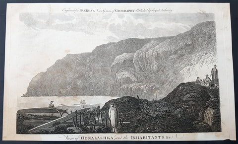
1787 Bankes Antique Print English or Nanwalek Bay Alaska, Cooks 3rd Voyage 1778
- Title : View of Oonalashka and the Inhabitants
- Size: 14in x 9in (355mm x 230mm)
- Ref #: 40213
- Date : 1787
- Condition: (A) Very Good Condition
Description:
This fine original cooper-plate engraved antique print a view of English or Nanwalek Bay, Alaska visited by Captain James Cook in June/July 1778, during his third voyage of discovery - after John Webber - was published in Thomas Bankes 1787 edition of A New, Royal and Authentic System of Universal Geography, Antient and Modern..... printed by Charles Cook, London.
Cooks Third Voyage (1776-1779)
In the course of his first two voyages, Cook circumnavigated the globe twice, sailed extensively into the Antarctic, and charted coastlines from Newfoundland to New Zealand. Following these achievements, Cook\'s third voyage was organized to seek an efficient route from England to southern and eastern Asia that would not entail rounding the Cape of Good Hope. The search for such a Northwest (or Northeast) Passage had been on the agenda of northern European mariners and merchants since the beginning of European expansion in the late fifteenth century. England\'s growing economic and colonial interests in India in the later eighteenth century provided the stimulus for the latest exploration for this route.
Cook, again in command of the Resolution, was to approach the Northwest Passage from the Pacific accompanied by a second ship, the Discovery, captained by Charles Clerke. The ships left England separately, regrouped at Cape Town, and continued on to Tasmania, New Zealand, and Tahiti. The expedition then sailed north and made landfall at Christmas Island and the Hawaiian Islands. Cook continued northward and charted the west coast of North America from Northern California as far as the Bering Strait. He returned to Hawaii for the winter and was killed in a skirmish with natives on February 14, 1779. Upon Cook\'s death, Clerke took command of the expedition but died six months later. The ships returned to England in 1780 under John Gore, who had commanded the Discovery after Cook\'s death. From start to finish, the voyage had lasted more than four years. (Ref Tooley; M&B; Clancy)
General Definitions:
Paper thickness and quality: - Heavy and stable
Paper color : - off white
Age of map color: -
Colors used: -
General color appearance: -
Paper size: - 14in x 9in (355mm x 230mm)
Plate size: - 12in x 7 1/2in (305mm x 190mm)
Margins: - Min 1/2in (12mm)
Imperfections:
Margins: - None
Plate area: - None
Verso: - None
Background:
Nanwalek, formerly Alexandrovsk and English Bay, Alaska is census-designated place (CDP) in the Kenai Peninsula Borough, Alaska, United States that contains a traditional Alutiiq village.
Cooks Diary.......English Bay, Unalaska......the next day, the 27th, wrote Cook the fog partly despersed. At 7 AM wieghed and steered to the North… the wind faild and obliged us to Anchor. They sailed on and anchored in a bay for a few days on 28th. According to Samwell the next day We hoisted out our launch sent her ashore to fill the empty Water Casks both Ships completed their water. On 30th Many Canoes trading about the Ship… We find many Notes written in the Russian Language among these People dated in the Year 1776. The weather was, wrote Samwell moderate & hazy
1821 Brue Large Antique Map of Siberia, Alaska, Behring Straits, North America
- Title : Carte Generale De La Russie D Asie et des Regions Polaris Borales...1821
- Ref #: 32455
- Size: 24in x 20in (610mm x 510mm)
- Date : 1821
- Condition: (A+) Fine Condition
Description:
This large beautifully engraved hand coloured original antique map of Siberia and more importantly an early mapping of Alaska and the Bering Straits - was engraved in 1821 - the date is engraved in the title - and was published in Adrien Brues (1786 - 1832) Universel de Geographie. (Ref: M&B; Tooley)
General Description:
Paper thickness and quality: - Heavy and stable
Paper color: - Off white
Age of map color: - Original
Colors used: - Yellow, pink, green, blue
General color appearance: - Authentic
Paper size: - 24in x 20in (610mm x 510mm)
Plate size: - 22in x 16in (560mm x 410mm)
Margins: - Min 1in (25mm)
Imperfections:
Margins: - None
Plate area: - None
Verso: - Bottom centerfold re-joined, no loss

1861 Migeon Large Antique Map of North America, inset of Niagara Falls
- Title : Amerique Septentrionale
- Date : 1861
- Condition: (A+) Fine Condition
- Ref: 60567
- Size: 18in x 13 1/2in (460mm x 345mm)
Description:
This large fine beautifully hand coloured original antique map of North America - with an inset view of Niagara Falls - was published by J Migeon in his 1861 edition of Geographer Universal. (Ref: M&B; Tooley)
General Description:
Paper thickness and quality: - Heavy & stable
Paper color: - White
Age of map color: - Original
Colors used: - Pink, yellow, green, blue
General color appearance: - Authentic
Paper size: - 18in x 13 1/2in (460mm x 345mm)
Plate size: - 18in x 13 1/2in (460mm x 345mm)
Margins: - Min 1in (25mm)
Imperfections:
Margins: - None
Plate area: - None
Verso: - None