Welcome to Classical Images!
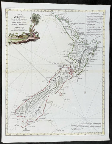
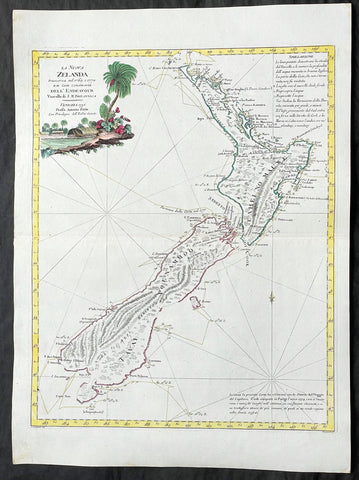
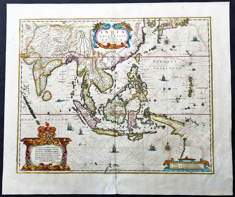
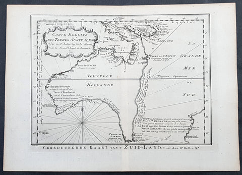
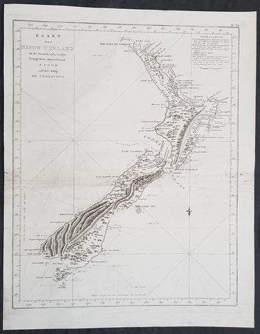
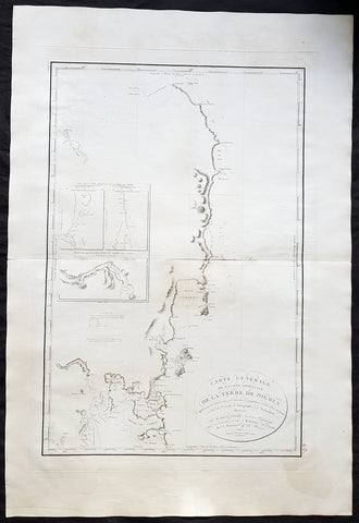
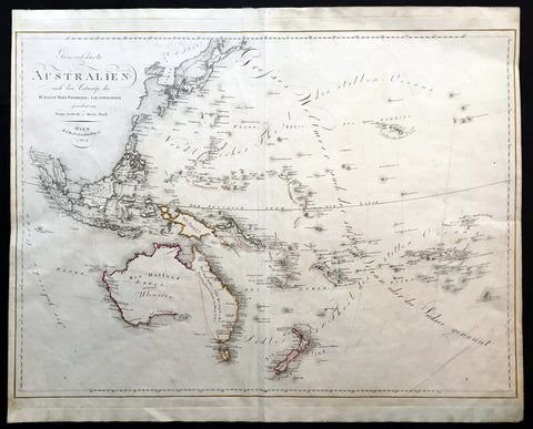
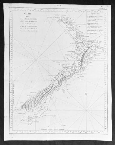
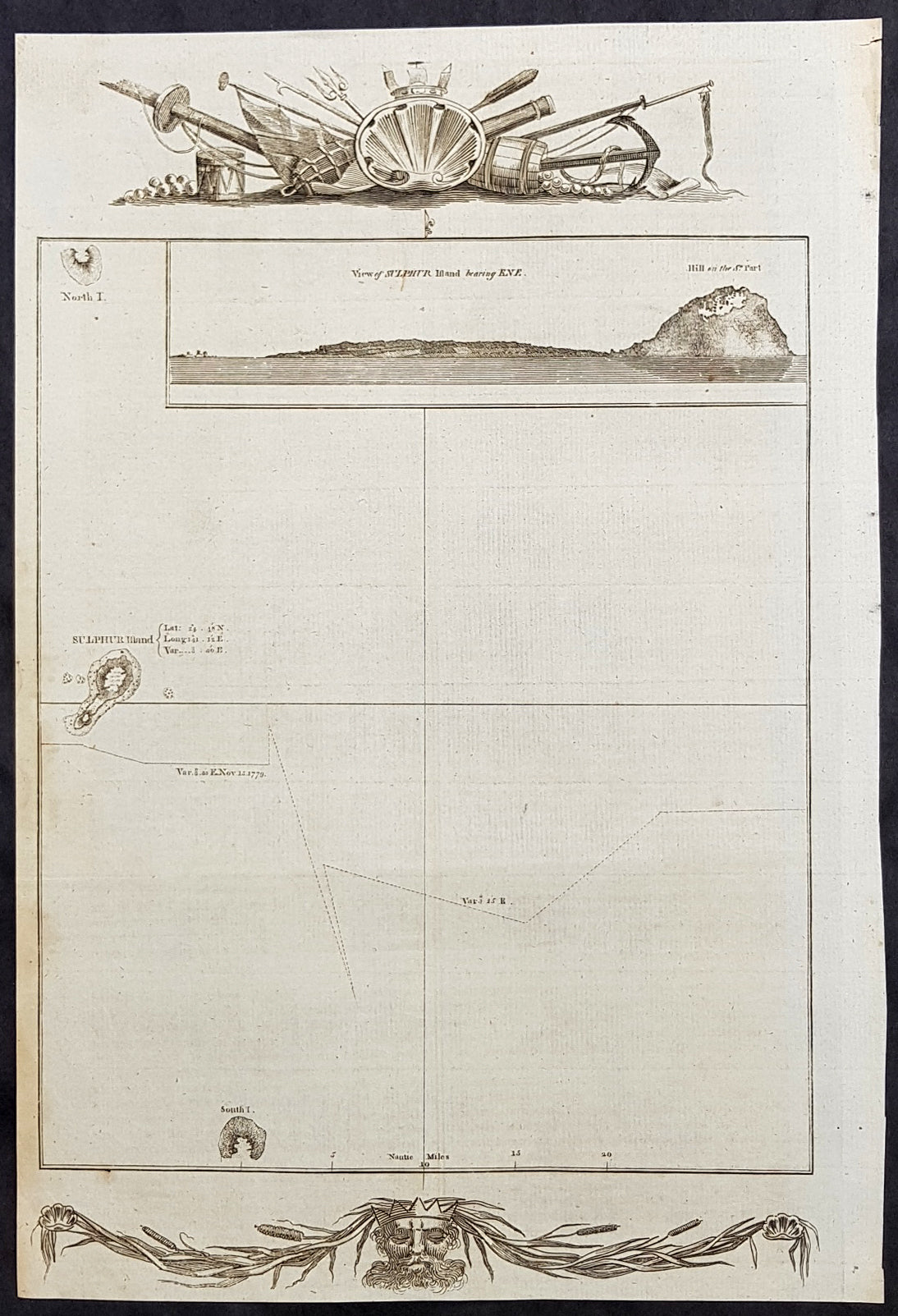
Description:This fine original copper-plate engraved antique map of the Japanese Island of Iwo Jima (Sulphur Island) and the tracks of HMS Resolution, was charted by Cooks expedition on 14 November 1779, after the death of Cook, during his third and final Voyage of Discovery, was published in George Andersons 1784 edition of A Collection of voyages round the world : performed by royal authority : containing a complete historical account of Captain Cooks first, second, third and last voyages, undertaken for making new discoveries, &c. ... published by Alexander Hogg, London 1784.From Cooks/Gore Diary..........and the strong sulphureous smell which we perceived, as we approached the point. ... From these circumstances, Captain Gore gave it the name of Sulphur Island.
General Definitions:Paper thickness and quality: - Heavy and stablePaper color : - off whiteAge of map color: -Colors used: -General color appearance: -Paper size: - 13 1/2in x 9 1/2in (345mm x 240mm)Plate size: - 13 1/2in x 9 1/2in (345mm x 240mm)Margins: - Min 1/2in (12mm)
Imperfections:Margins: - NonePlate area: - NoneVerso: - None
Background: Iwo To (硫黄島 Iō-tō, sulfur island), known in English as Iwo Jima, is an island of the Japanese Volcano Islands chain south of the Ogasawara Islands and together with them forms the Ogasawara Archipelago also known as the Bonin Islands. The island of 21 km2 is 1,200 kilometres south of mainland Tokyo and is administered as part of Ogasawara, one of the eight villages of Tokyo inhabited only by Japan Self-Defense Forces and used by the U.S. Navy for carrier practice.Cooks Third Voyage (1776–79)On his last voyage, Cook again commanded HMS Resolution, while Captain Charles Clerke commanded HMS Discovery. The voyage was ostensibly planned to return the Pacific Islander, Omai to Tahiti, or so the public were led to believe. The trip\\\'s principal goal was to locate a Northwest Passage around the American continent. After dropping Omai at Tahiti, Cook travelled north and in 1778 became the first European to begin formal contact with the Hawaiian Islands. After his initial landfall in January 1778 at Waimea harbour, Kauai, Cook named the archipelago the \\\"Sandwich Islands\\\" after the fourth Earl of Sandwich—the acting First Lord of the Admiralty.From the Sandwich Islands Cook sailed north and then north-east to explore the west coast of North America north of the Spanish settlements in Alta California. He made landfall on the Oregon coast at approximately 44°30′ north latitude, naming his landing point Cape Foulweather. Bad weather forced his ships south to about 43° north before they could begin their exploration of the coast northward. He unknowingly sailed past the Strait of Juan de Fuca, and soon after entered Nootka Sound on Vancouver Island. He anchored near the First Nations village of Yuquot. Cook\\\'s two ships remained in Nootka Sound from 29 March to 26 April 1778, in what Cook called Ship Cove, now Resolution Cove, at the south end of Bligh Island, about 5 miles (8 km) east across Nootka Sound from Yuquot, lay a Nuu-chah-nulth village (whose chief Cook did not identify but may have been Maquinna). Relations between Cook\\\'s crew and the people of Yuquot were cordial if sometimes strained. In trading, the people of Yuquot demanded much more valuable items than the usual trinkets that had worked in Hawaii. Metal objects were much desired, but the lead, pewter, and tin traded at first soon fell into disrepute. The most valuable items which the British received in trade were sea otter pelts. During the stay, the Yuquot \\\"hosts\\\" essentially controlled the trade with the British vessels; the natives usually visited the British vessels at Resolution Cove instead of the British visiting the village of Yuquot at Friendly Cove.After leaving Nootka Sound, Cook explored and mapped the coast all the way to the Bering Strait, on the way identifying what came to be known as Cook Inlet in Alaska. In a single visit, Cook charted the majority of the North American north-west coastline on world maps for the first time, determined the extent of Alaska, and closed the gaps in Russian (from the West) and Spanish (from the South) exploratory probes of the Northern limits of the Pacific.By the second week of August 1778 Cook was through the Bering Strait, sailing into the Chukchi Sea. He headed north-east up the coast of Alaska until he was blocked by sea ice. His furthest north was 70 degrees 44 minutes. Cook then sailed west to the Siberian coast, and then south-east down the Siberian coast back to the Bering Strait. By early September 1778 he was back in the Bering Sea to begin the trip to the Sandwich (Hawaiian) Islands. He became increasingly frustrated on this voyage, and perhaps began to suffer from a stomach ailment; it has been speculated that this led to irrational behaviour towards his crew, such as forcing them to eat walrus meat, which they had pronounced inedible.Cook returned to Hawaii in 1779. After sailing around the archipelago for some eight weeks, he made landfall at Kealakekua Bay, on \\\'Hawaii Island\\\', largest island in the Hawaiian Archipelago. Cook\\\'s arrival coincided with the Makahiki, a Hawaiian harvest festival of worship for the Polynesian god Lono. Coincidentally the form of Cook\\\'s ship, HMS Resolution, or more particularly the mast formation, sails and rigging, resembled certain significant artefacts that formed part of the season of worship. Similarly, Cook\\\'s clockwise route around the island of Hawaii before making landfall resembled the processions that took place in a clockwise direction around the island during the Lono festivals. It has been argued (most extensively by Marshall Sahlins) that such coincidences were the reasons for Cook\\\'s (and to a limited extent, his crew\\\'s) initial deification by some Hawaiians who treated Cook as an incarnation of Lono. Though this view was first suggested by members of Cook\\\'s expedition, the idea that any Hawaiians understood Cook to be Lono, and the evidence presented in support of it, were challenged in 1992.After a month\\\'s stay, Cook attempted to resume his exploration of the Northern Pacific. Shortly after leaving Hawaii Island, however, the Resolution\\\'s foremast broke, so the ships returned to Kealakekua Bay for repairs.Tensions rose, and a number of quarrels broke out between the Europeans and Hawaiians at Kealakekua Bay. An unknown group of Hawaiians took one of Cook\\\'s small boats. The evening when the cutter was taken, the people had become \\\"insolent\\\" even with threats to fire upon them. Cook was forced into a wild goose chase that ended with his return to the ship frustrated.[53] He attempted to kidnap and ransom the King of Hawaiʻi, Kalaniʻōpuʻu.That following day, 14 February 1779, Cook marched through the village to retrieve the King. Cook took the King (aliʻi nui) by his own hand and led him willingly away. One of Kalaniʻōpuʻu\\\'s favorite wives, Kanekapolei and two chiefs approached the group as they were heading to boats. They pleaded with the king not to go until he stopped and sat where he stood. An old kahuna (priest), chanting rapidly while holding out a coconut, attempted to distract Cook and his men as a large crowd began to form at the shore. The king began to understand that Cook was his enemy. As Cook turned his back to help launch the boats, he was struck on the head by the villagers and then stabbed to death as he fell on his face in the surf. He was first struck on the head with a club by a chief named Kalaimanokahoʻowaha or Kanaʻina (namesake of Charles Kana\\\'ina) and then stabbed by one of the king\\\'s attendants, Nuaa. The Hawaiians carried his body away towards the back of the town, still visible to the ship through their spyglass. Four marines, Corporal James Thomas, Private Theophilus Hinks, Private Thomas Fatchett and Private John Allen, were also killed and two others were wounded in the confrontation.The esteem which the islanders nevertheless held for Cook caused them to retain his body. Following their practice of the time, they prepared his body with funerary rituals usually reserved for the chiefs and highest elders of the society. The body was disembowelled, baked to facilitate removal of the flesh, and the bones were carefully cleaned for preservation as religious icons in a fashion somewhat reminiscent of the treatment of European saints in the Middle Ages. Some of Cook\\\'s remains, thus preserved, were eventually returned to his crew for a formal burial at sea.Clerke assumed leadership of the expedition, and made a final attempt to pass through the Bering Strait. He died from tuberculosis on 22 August 1779 and John Gore, a veteran of Cook\\\'s first voyage, took command of Resolution and of the expedition. James King replaced Gore in command of Discovery. The expedition returned home, reaching England in October 1780. After their arrival in England, King completed Cook\\\'s account of the voyage.David Samwell, who sailed with Cook on Resolution, wrote of him: \\\"He was a modest man, and rather bashful; of an agreeable lively conversation, sensible and intelligent. In temper he was somewhat hasty, but of a disposition the most friendly, benevolent and humane. His person was above six feet high: and, though a good looking man, he was plain both in dress and appearance. His face was full of expression: his nose extremely well shaped: his eyes which were small and of a brown cast, were quick and piercing; his eyebrows prominent, which gave his countenance altogether an air of austerity.