Welcome to Classical Images!
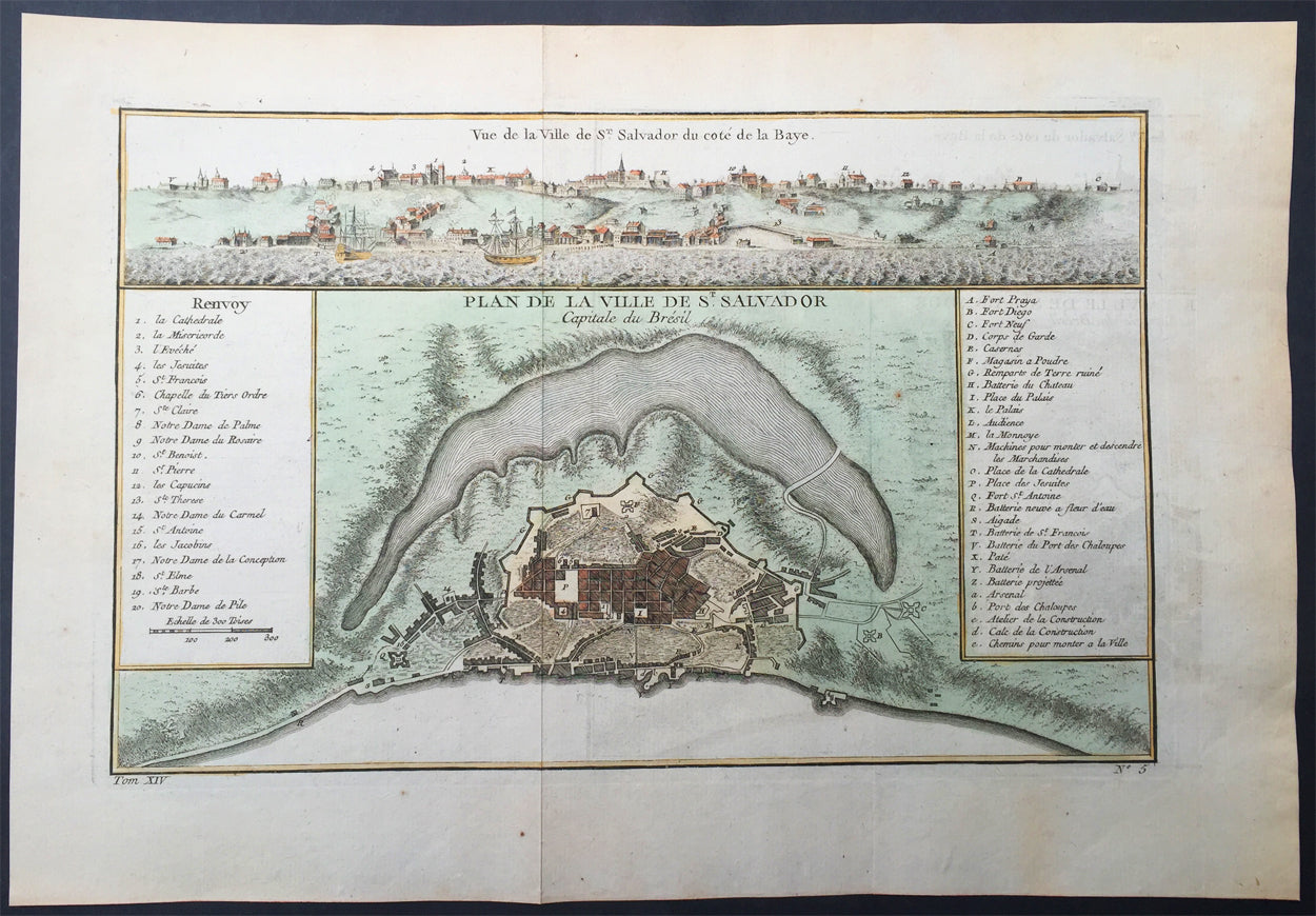
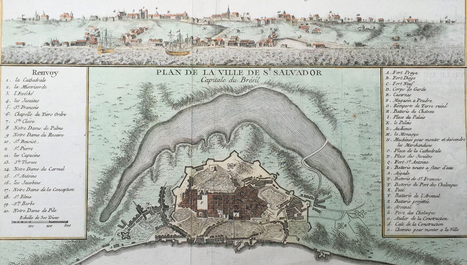
Description: This beautifully hand coloured original antique map* and view of the Brazilian City of Salvador - with building index - by Jacques Nicolas Bellin was published in the 1757 French & Dutch edition of Antoine-François Prevosts 20 volume L`Histoire Generale des Voyages published by Pierre de Hondt in the Hague between 1747 & 1785.
Background: Salvador, also known as São Salvador, Salvador de Bahia, and Salvador da Bahia (Brazilian Portuguese) is the capital of the Brazilian state of Bahia. With 2.9 million people (2013), it is the largest city proper in the Northeast Region and the 3rd-largest city proper in the country, after São Paulo and Rio de Janeiro. Salvador lies on a small, roughly triangular peninsula that separates the Bay of All Saints from the Atlantic Ocean. The bay is the largest in Brazil and the 2nd-largest in the world. It was first reached by Gaspar de Lemos in 1501, just one year after Cabral's purported discovery of Brazil. During his second voyage for Portugal, the Italian explorer Amerigo Vespucci sighted the bay on All Saints' Day (November 1) 1502 and, in honor of the date and his parish church in Florence, he named it the Bay of the Holy Savior of All the Saints. The first European to settle nearby was Diogo Álvares Correia ("Caramuru"), who was shipwrecked off the end of the peninsula in 1509. He lived among the Tupinambá, marrying Guaibimpara and others. In 1531, Martim Afonso de Sousa led an expedition from Mount St Paul (Morro de São Paulo) and, in 1534,Francisco Pereira Coutinho, the first captain of Bahia, established the settlement of Pereira in modern Salvador's Ladeira da Barra neighborhood. Mistreatment of the Tupinambá by the settlers caused them to turn hostile and the Portuguese were forced to flee to Porto Seguro c. 1546. An attempted restoration of the colony the next year ended in shipwreck and cannibalism. The present city was established as the fortress of Sao Salvador da Bahia de Todos os Santos ("Holy Savior of the Bay of All Saints") in 1549 by Portuguese settlers under Tomé de Sousa, Brazil's first governor-general. It is one of the oldest cities founded by Europeans in the Americas. From a cliff overlooking the Bay of All Saints, it served as Brazil's first capital and quickly became a major port for its slave trade and sugarcane industry. Salvador was long divided into an upper and a lower city, divided by a sharp escarpment some 85 meters (279 ft) high. The upper city formed the administrative, religious, and primary residential districts while the lower city was the commercial center, with a port and market. In the Catholic Church, Brazil and the rest of the Portuguese Empire were initially administered as part of the Diocese of Funchal in Portugal but, in 1551, Salvador became the seat of the first Catholic diocese erected in Brazil. The first parish church was the mud-and-thatch Church of Our Lady of Help (Igreja da Nossa Senhora da Ajuda) erected by the Jesuits, which served as the first cathedral of the diocese until the Jesuits finished construction of the original basilica on the Terreiro de Jesus in 1553. Its bishop was made independent of Lisbon at the request of King Pedro II in 1676; he served as the primate of Congo and Angola until the elevation of Luanda on 13 January 1844 and still serves as the national primate of Brazil. In 1572, the Governorate of Brazil was divided into the separate governorates of Bahia in the north and Rio de Janeiro in the south. These were reunited as Brazil six years later, then redivided from 1607 to 1613. By that time, Portugal had become united with Spain and was ruled from Madrid by its kings. In 1621, King Philip III replaced the Governorate of Brazil with the states of Brazil, still based in Salvador and now controlling the south, and the Maranhão, which was centered on São Luís and controlled what is now northern Brazil. As Spain was then prosecuting a war against the independence of the Dutch, the Dutch East and West India companies tried to conquer Brazil from them. Salvador played a strategically vital role against Dutch Brazil, but was captured and sacked by a West India Company fleet under Jacob Willekens and Piet Hein on 10 May 1624. Johan van Dorth administered the colony before his assassination, freeing its slaves. The city was recaptured by a Luso-Spanish fleet under Fadrique Álvarez de Toledo y Mendoza on 1 May 1625. John Maurice's two subsequent attempts to retake the town in April and May of 1638 were unsuccessful. In 1763, the colonial administration was removed to Rio de Janeiro and elevated to a viceroyalty. Salvador remained the heart of the Recôncavo, Bahia's rich agricultural maritime district, but was largely outside Brazil's early modernization. The area formed a center of royal support against Pedro I's declaration of independence on September 7, 1822. Its elites initially remained loyal to the Portuguese crown while rebels from Cachoeira besieged them for a year until finally receiving Portugal's surrender of the town on July 2, 1823, which is now celebrated as Bahia Independence Day. The local elite was similarly hesitant during Manuel Deodoro da Fonseca's coup that established the republic by in 1889. Owing to whales' use of the Bay of All Saints as a mating ground, Salvador became a large whaling port during the 19th century but the trade had already begun to fall off by the 1870s. Under the empire and republic, however, the town slowly began to industrialize. In 1873, Brazil's first elevator, the powerful hydraulic Elevador Lacerda, was constructed to connect the city's upper and lower towns. Having undergone several upgrades, it continues in use. By the First World War, it was joined by a second elevato and Salvador was connected to four railroads: the Bahia & Alagoinhas to Joazeiro, the Bahia Central, the Nazareth Tramway, and a short line to Santo Amaro. Its central districts and the major suburbs of Bomsim and Victoria were served by four streetcar lines, which had begun to electrify. It also served as a port of call for most steamship lines trading between Europe and South America. (Ref: Tooley; M&B)
General Description: Paper thickness and quality: - Heavy and stable Paper color: - off white Age of map color: - Early Colors used: - Yellow, green, red, brown. General color appearance: - Authentic and fresh Paper size: - 14in x 10in (355mm x 255mm) Plate size: - 12in x 8in (305mm x 205mm) Margins: - Min 1in (25mm)
Imperfections: Margins: - None Plate area: - Folds as issued Verso: - None